MAAP #96: Gold Mining Deforestation At Record High Levels In Southern Peruvian Amazon
January 8, 2019
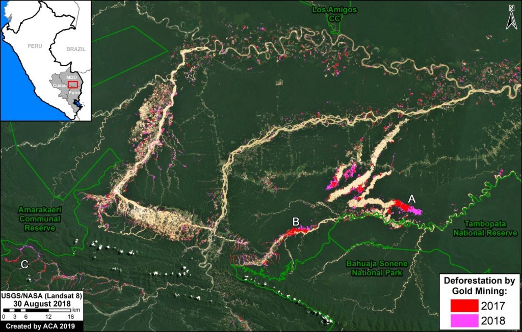
Gold mining deforestation has been at record high levels in both 2017 and 2018 in the southern Peruvian Amazon.
Based on an analysis of nearly 500 high-resolution satellite images (from Planet and DigitalGlobe), we estimate the deforestation of 18,440 hectares across southern Peru during these last two years. That is equivalent to 45,560 acres (or 34,400 American football fields) in just two years.
The Base Map highlights this recent deforestation, with 2017 in red and 2018 in pink. The Reference Map in Annex 1 shows our full study area.
2017 had the highest gold mining deforestation on record at the time: 9,160 hectares (22,635 acres). According to recent research led by CINCIA (Centro de Innovación Científica Amazónica), this was the highest annual total on record dating back to 1985*.
In 2018, we found the gold mining deforestation was even higher: 9,280 hectares (22,930 acres).
Thus, combined, 2017-18 had the highest two-year deforestation total on record: 18,440 hectares (45,565 acres).
Note the location of Zooms (A-C) shown in greater detail below. These zooms represent three of the most threatened areas: A) La Pampa, B) Upper Malinowski, and C) Camanti.
Click (or right click) to enlarge (or download) images.
*CINCIA reports 9,860 hectares of gold mining deforestation in 2017 (CINCIA 2018, Caballero Espejo et al 2018), an estimate even higher than ours.
Zoom A: La Pampa
Image A shows the gold mining deforestation of 1,685 hectares (4,164 acres) between 2017 (left panel) and 2018 (right panel) in an area known as La Pampa (Madre de Dios region). Red indicates the major deforestation fronts.
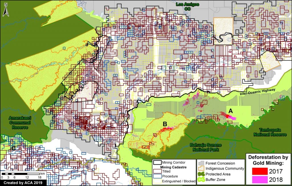
As seen in the Land Use Map below (Annex 2), most of the recent mining deforestation in La Pampa is clearly illegal, concentrated in reforestation concessions and the buffer zone of Tambopata National Reserve.
According to the web portal GEOCATMIN (Geological Information System and Mining Register), developed by INGEMMET (Geological Mining and Metallurgical Institute of Peru), all titled mining concessions in the area are currently “without mining activity.” None are in authorized Exploration or Exploitation phase. Most of the mining activity is outside these concessions and in areas not authorized for mining.
Zoom B: Upper Malinowski
Image B shows the gold mining deforestation of 760 hectares (1,878 acres) between 2017 (left panel) and 2018 (right panel) along the upper stretches of the Malinowski River in the Madre de Dios region. Red indicates the major deforestation fronts.
As seen in the Land Use Map below (Annex 2), the recent gold mining deforestation along the Upper Malinowski is advancing in the Kotsimba Native Community and within the buffer zone of Bahuaja Sonene National Park.
According to GEOCATMIN, all titled mining concessions in the area are currently “without mining activity.” None are in authorized Exploration or Exploitation phase. Most of the mining activity is outside these concessions and in areas not authorized for mining.
Zoom C: Camanti
Image 4 shows the gold mining deforestation of 335 hectares (828 acres) between 2016 (left panel) and 2018 (right panel) in the Camanti area of the Cusco region. Red indicates the major deforestation fronts. Note the increasing proximity of the mining to Amarakaeri Communal Reserve.
As seen in the Land Use Map below (Annex 2), the recent gold mining in the Camanti area is advancing in mining concessions that are “in process” of titling. According to GEOCATMIN, there are no titled concessions in the area that are in Exploration or Exploitation phase.
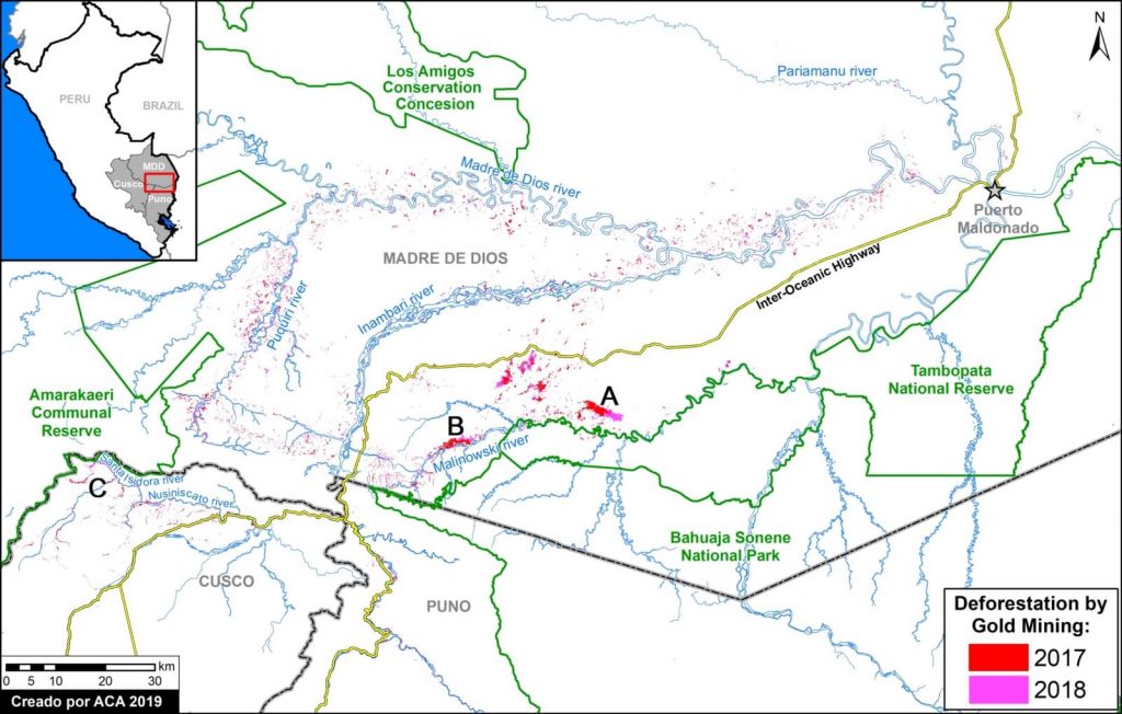
Annex 1: Reference Map
Annex 1 features a Reference Map of our full study area. The background is white to better indicate the mining deforestation areas. It also serves as a reference map with additional labels.
Annex 2: Land Use Map
Annex 2 features a Land Use Map with detailed data on mining concessions and other important land designations. The mining concession data comes from the web portal GEOCATMIN (Geological Information System and Mining Register), developed by INGEMMET (Geological Mining and Metallurgical Institute of Peru). We downloaded the data on January 2, 2019.
Methodology
We analyzed high-resolution satellite imagery (DigitalGlobe and Planet) for both 2017 and 2018 and digitized all new gold mining deforestation. Given the widespread mining across a large area, we also used automated forest loss alerts based on medium resolution Landsat imagery (PNCB/MINAM) to guide our analysis.
References
Centro de Innovación Científica Amazónica (CINCIA) (2018) Tres décadas de deforestación por minería aurífera en la Amazonía suroriental peruana. Resumen de Investigación No. 1.
Caballero Espejo et al. (2018) Deforestation and Forest Degradation Due to Gold Mining in the Peruvian Amazon: A 34-Year Perspective. Remote Sens. 2018, 10 (12), 1903; https://doi.org/10.3390/rs10121903
Asner GP and Tupayachi R (2016) Environ. Res. Lett. 12 094004.
Planet Team (2017). Planet Application Program Interface: In Space for Life on Earth. San Francisco, CA. https://api.planet.com
Acknowledgements
We thank the following colleagues for helpful comments: Miles Silman (Wake Forest Univ), Sidney Novoa (ACCA), Ronald Catpo (ACCA), Efrain Samochuallpa (ACCA), Daniela Pogliani (ACCA), Alfredo Cóndor (ACCA), and Lorena Durand (ACCA).
Citation
Finer M, Mamani N (2018) Gold Mining Deforestation at Record High Levels in Southern Peruvian Amazon. MAAP: 96.


 Loading...


