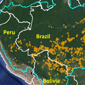
Our Monitoring of the Andes Amazon Program (MAAP), is at the forefront of the field of high-tech, real-time monitoring. Launched in 2015, MAAP’s innovative application of satellite technology from multiple sources delivers actionable information that provides a transformational tool for governments and local people to rapidly detect deforestation as it is happening. MAAP satellite monitoring covers 100% of the Amazon biome in all 9 countries that it encompasses: Peru, Brazil, Colombia, Ecuador, Bolivia, Venezuela, Guyana, Suriname, and French Guiana and our findings have been featured in major English, Spanish, and Portuguese news sources such as Reuters, Mongabay, Mongabay LatAm, CNN, as well as key local news sources such as Agencia Efe, El Comercio (Peru), El Diario, and La Nacional.
MAAP’s methodology, published in Science in 2018, effectively combines remote sensing technologies (drones, radar, analytical algorithms, and more) to provide reports pinpointing the most urgent deforestation happening across the Amazon in real-time, when responsive and preventative action is still possible.
MAAP can identify and determine the legality of deforestation at any scale and at any point across the entire Amazon basin – an area roughly the size of the forty-eight contiguous United States. With a small team of 5 using smart technology tools, MAAP’s cost-effective model is accessible not only to governments as a long-term protection solution but also to local communities and indigenous groups that need to know where illegal activities and encroachment on their lands are happening on a daily basis.
Thanks to recent advances in satellite technology and analytical tools, MAAP is able to monitor every hectare of vast and remote areas quickly and thoroughly. Automated forest loss alerts, access to daily high-resolution imagery, and satellite imagery tasking allow our small expert team to conduct real-time monitoring that just a few years ago would have required costly, time-intensive, and even dangerous field operations with a high potential for direct conflict. Even then, most of these operations get to the forest after irreversible damage has already been done and the perpetrators have already fled, perpetuating a culture of impunity. Now, MAAP is able to track deforestation, identify illegal acts on the spot, and help halt illegal activity, thus making enforcement operations more timely and impactful.
Last year (2020), we demonstrated the power of our real-time Amazon fire monitoring app (see MAAP #118 and MAAP #129). In a novel approach, the app uniquely combines data from the atmosphere (aerosol emissions in smoke) and the ground (heat anomaly alerts) to quickly and precisely detect major Amazon fires.* Using the app, we just detected the first two major fires in the Brazilian […]
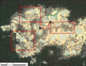
In 2019, the Peruvian government launched Operation Mercury to confront the illegal gold mining crisis in the southern Amazonian area known as La Pampa (Madre de Dios region).As a result, deforestation decreased 90% in this critical area (MAAP# 130). Some illegal gold mining, however, has moved to several new hotspots (Image 1), although at much lower levels. The […]
Brazil is currently in high-profile negotiations with countries such as the United States and Norway for international compensation in exchange for improved action to address Amazon deforestation.* While this may be a positive development diplomatically, on the ground extensive deforestation continues. We recently reported that, in 2020, Brazil had the sixth-highest primary forest loss on record (1.5 million […]
 Through MAAP, we’re able to document significant deforestation cases in near real-time and identify the direct causes of such deforestation. Our timespan is within hours or days to quickly spot deforestation and quantify the damage. Potential issues are identified using lower-resolution satellite imagery, where we later utilize high-resolution images of sites on demand to further investigate the nature of the deforestation. Our findings can then be shared with government officials to locate mining activities as they are happening. Additionally, we also used this data to better understand larger-scale deforestation patterns, hotspots, and drivers.
The information compiled is then summarized into confidential policy briefs and presented to policymakers0 and government officials that have the capacity to take action on the ground or write policy that advances conservation. Additionally, we make our MAAP reports public, by publishing them on our website maaproject.org.
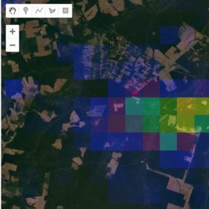
With our fire tracking app we developed as part of MAAP, we documented over 2,500 major fires across the Amazon in 2020. The Amazon real-time fire monitoring app is hosted by Google Earth Engine and uses a combination of heat-based fire alerts with aerosol emissions to detect major fires.
When fires burn, they emit gases and aerosols. A new satellite (Sentinel-5P from the European Space Agency) detects these aerosol emissions. The major feature of the app is user-friendly and real-time identification of major fires across the Amazon, based on the aerosol emissions detected by Sentinel-5P. The app also contains the commonly-used “fire alerts,” which are satellite-based data of temperature anomalies.*
Thus, the user combines data from the atmosphere (aerosol) with data from the ground (temperature) to pinpoint the source of major fires. Since the data updates daily and is not impacted by clouds, real-time monitoring really was possible. Last fire season, we uploaded each day’s new image by midnight.
Read more about how our fire app is used to detect major fires.
In 2019, the Peruvian government launched an illegal gold mining crackdown known as Operation Mercury, to combat the rampant and illegal deforestation, human trafficking, and other illicit activities that happen as the result of an illegal gold mining camp. This crackdown lasted for two weeks and used our MAAP satellite imagery to identify and locate the illegal gold mining operations, in a collaborative effort between 1,200 Peruvian police, 300 soldiers, and 70 prosecutors.
As a result, in a December 2020 MAAP report, we showed that there was a 78% decrease in gold mining deforestation across six sites in the Peruvian Amazon after Operation Mercury. Gold mining deforestation also decreased by a whopping 90% in La Pampa, a region where illegal mining activities were also a major threat.
 Since Operation Mercury, MAAP has also provided nonpublic reports directly to the Peruvian government. With each cycle of reporting illegal activity, government crackdowns and further analysis, deforestation rates are slowing in the areas we study.
The cycle begins with technology. Satellites are our most powerful tool, and we use an array of satellites with different resolutions. To begin we spot a potential area of deforestation or investigate a deforestation alert using a lower resolution satellite. Then we prioritize the data, such as where the deforestation is, whether it is illegal or not, and other related factors. Once we have determined the significance of the deforestation, we further investigate the drivers with higher resolution satellite imagery.
This information is taken and compiled into reports, as shown in our Step 2: Reporting section of the cycle. We have two types of reports: public reports via our MAAP website, and private policy briefs for government agencies. Our public reports may be picked up by major news sources, which sometimes results in the public putting more pressure on authorities to address the deforestation.
Reporting leads to our last section of the circle, which is on action taken to stop the deforestation or policies created to reduce deforestation. Action can take the form of administrative action, an intervention of illegal activities, creating policy to better address forest crimes, or legal repercussions for offenders.
MAAP currently specializes in three types of real-time monitoring and tracking across the Amazon basin – deforestation, fires, and selective logging – and provides to authorities and local actors in Peru.
In order to achieve the scale and depth of coverage that governments and people need, we are extending our work to provide data on some of the most urgent and impactful deforestation, degradation, and climate issues of the day across 100% of the Amazon, expanding support for local governments to enact the rule of law, and continuing to evolve with the latest advances in technology that keep our efforts highly impactful and cost-effective.

Our goal is for MAAP to grow to answer vital thematic questions happening across country borders that can influence regional policymaking as well as deepen our locally-driven model that allows us to answer the in-depth questions that local authorities and communities need in order to protect their forests.

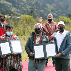
We are continually building partnerships with local communities, indigenous groups, fellow NGOs, and government agencies to expand the use of our real-time monitoring program locally and to increase the capacity of each country fighting deforestation through law enforcement.

One of the core concepts of MAAP since its founding has been employing new and evolving technologies, and staying agile to add the latest tech advances to our portfolio. We are not tied to any single technology or platform, which allows us to pilot and incorporate the latest cutting-edge technologies into our work - constantly adding new datasets, algorithms, and technologies (radar, AI, machine learning) - to improve the speed and quality of detection of deforestation, fires, and carbon emissions.