MAAP#120: Deforestation In The Colombian Amazon – 2020
June 3, 2020
Here we present a first look at 2020 deforestation of primary forest in the Colombian Amazon, in relation to the new published annual data for 2019.*
This new data confirms that deforestation decreased in 2019 (91,400 hectares) after a peak in 2018 (153,900 hectares).
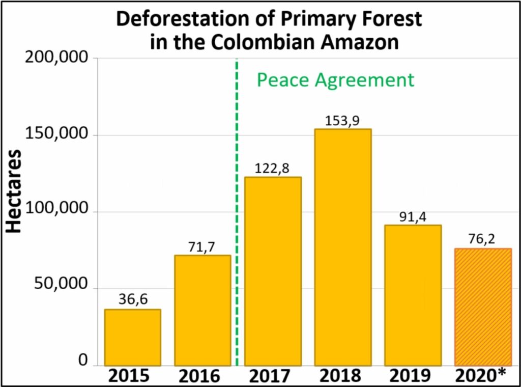
Table 1 shows the recent trend: a major deforestation spike following the 2016 peace agreement (between the Colombian government and the FARC) with a peak in 2018, followed by a major decrease in 2019.
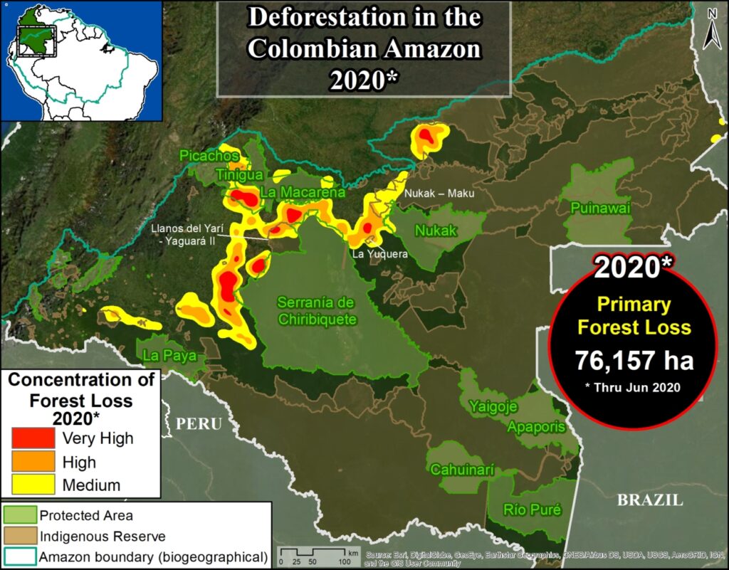
In our first look at 2020, we estimate the deforestation of 76,200 hectares (188,295 acres) of primary forest through June.
Note that we have documented the deforestation of 444,000 hectares (over a million acres) of primary forest in the Colombian Amazon in the past four years since the peace agreement.
*Global Forest Watch recently released the annual forest loss data for 2019.
Deforestation Hotspots – 2020
The Base Map shows the 2020 deforestation hotspots.*
As in previous years, they are concentrated in an “arc of deforestation” in the northwest Colombian Amazon.
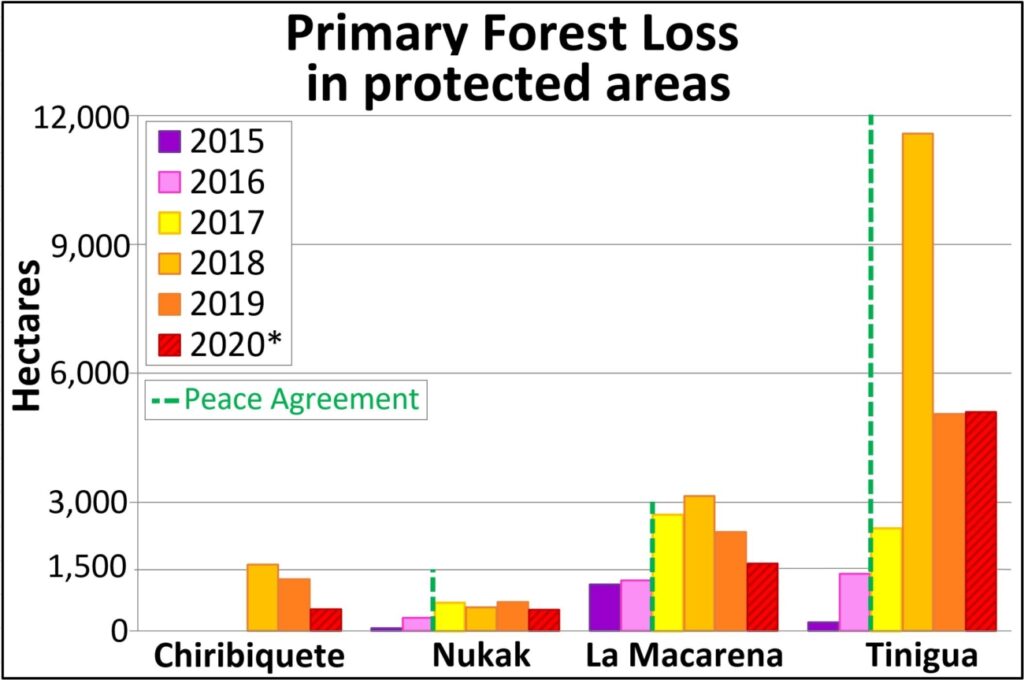
This arc includes four protected areas (Tinigua, Chiribiquete and Macarena National Parks, and Nukak National Reserve) that lost 0ver 7,700 hectares (19,000 acres) of primary forest in 2020 (see Table 2).
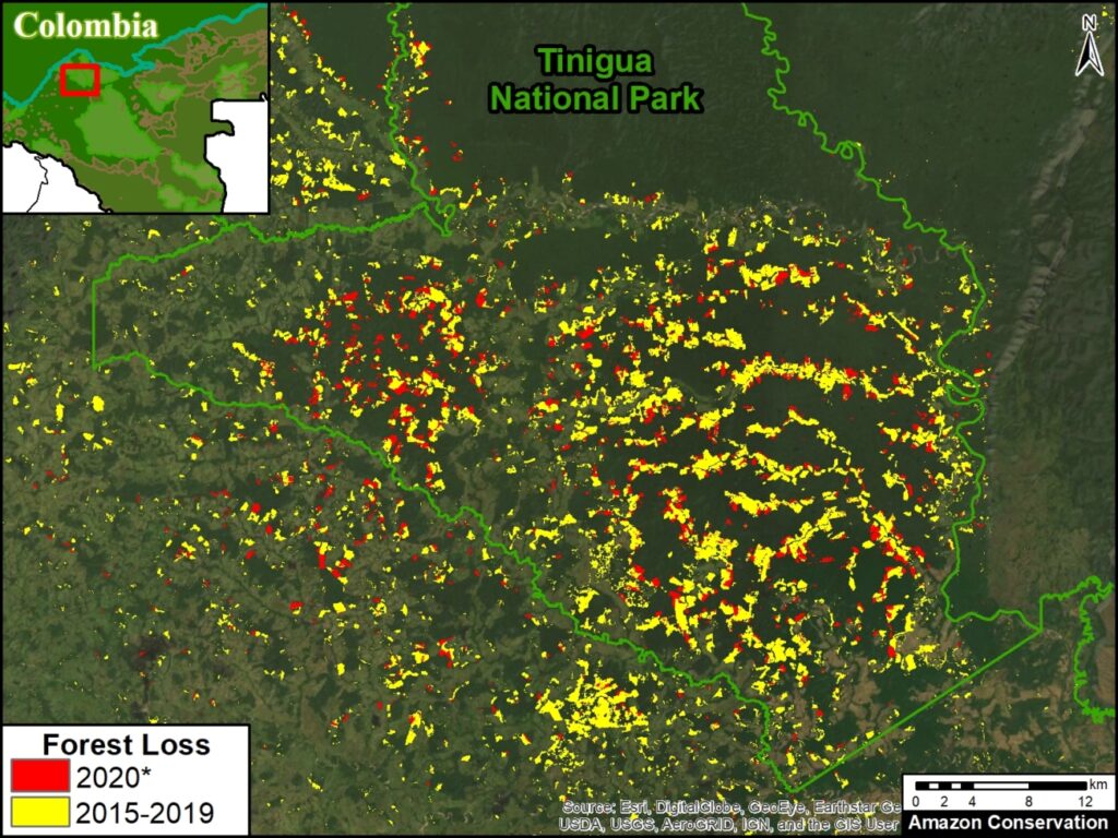
Tinigua National Park is the most impacted protected area with the deforestation of 5,100 hectares (12,600 acres). Note the rare occurrence of a major deforestation hotspot in the middle of a national park.
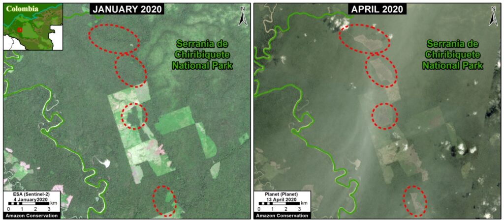
Chiribiquete National Park lost 510 hectares (1,260 acres) in the recently expanded sections of the park.
The arc of deforestation also includes two Indigenous Reserves (Resguardos Indígenas Nukak-Maku and Llanos del Yari-Yaguara II) that lost 4,000 hectares (9,885 acres) so far in 2020.
*To see detailed map of the 2019-20 primary forest deforestation in the Colombian Amazon, click here.
Deforestation in Protected Areas and Indigenous Lands – 2020
Below, we show 2020 examples within the arc of deforestation in the northwest Colombian Amazon.
Image 1 illustrates the extensive deforestation within Tinigua National Park over the last five years continuing in 2020.
Image 2 shows an example of deforestation within Chiribiquete National Park (western sector) between January (left panel) and April (right panel) of 2020.
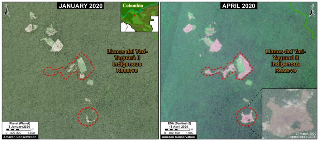
Image 3 shows an example of deforestation within the Llanos del Yari-Yaguara II Indigenous Reserve between January (left panel) and April (right panel) of 2020.
Deforestation in Protected Areas, 2015-20
Table 2 shows the loss of primary forest in four protected areas located in the arc of deforestation arc in the northwestern Colombian Amazon, between 2015 and 2020.
Methodology
The data presented in this report were generated by the Global Land Analysis and Discovery (GLAD) laboratory at the University of Maryland (Hansen et al 2013) and presented by Global Forest Watch. For the years 2015-18, we used annual forest loss data. For the years 2019-20, we used early warning alerts (GLAD alerts), and thus represent an estimate. Note that some forest loss detected early in the year may include events from late the preceding year.
Our study area is the Amazon biogeographical limit (not strict Amazon watershed) as highlighted in the Base Map.
Specifically, for our estimate of forest cover loss, we multiplied the annual “forest cover loss” data by the density percentage of the “tree cover” from the year 2001 (values >30%).
For our estimate of primary forest loss, we intersected the forest cover loss data with the additional dataset “primary humid tropical forests” as of 2001 (Turubanova et al 2018). For more details on this part of the methodology, see the Technical Blog from Global Forest Watch (Goldman and Weisse 2019).
All data were processed under the geographical coordinate system WGS 1984. To calculate the areas in metric units the UTM (Universal Transversal Mercator) projection was used: Colombia 18 North.
Lastly, to identify the deforestation hotspots, we conducted a kernel density estimate. This type of analysis calculates the magnitude per unit area of a particular phenomenon, in this case forest cover loss. We conducted this analysis using the Kernel Density tool from Spatial Analyst Tool Box of ArcGIS. We used the following parameters:
Search Radius: 15000 layer units (meters)
Kernel Density Function: Quartic kernel function
Cell Size in the map: 200 x 200 meters (4 hectares)
Everything else was left to the default setting.
For the Base Map, we used the following concentration percentages: Medium: 10%-20%; High: 21%-35%; Very High: >35%.
Acknowledgements
We thank R. Botero (FCDS), E. Ortiz (AAF), and G. Palacios for helpful comments to earlier versions of this report.
This work was supported by the following major funders: Norwegian Agency for Development Cooperation (NORAD), Gordon and Betty Moore Foundation, International Conservation Fund of Canada (ICFC), Metabolic Studio, Erol Foundation, MacArthur Foundation, and Global Forest Watch Small Grants Fund (WRI).
Citation
Finer M, Mamani N (2020) Deforestation in the Colombian Amazon – 2020. MAAP #120.

 Loading...


