
Satellite Images of “Rivers of Gold” Raise Awareness of Major Deforestation in the Amazon
February 28, 2021
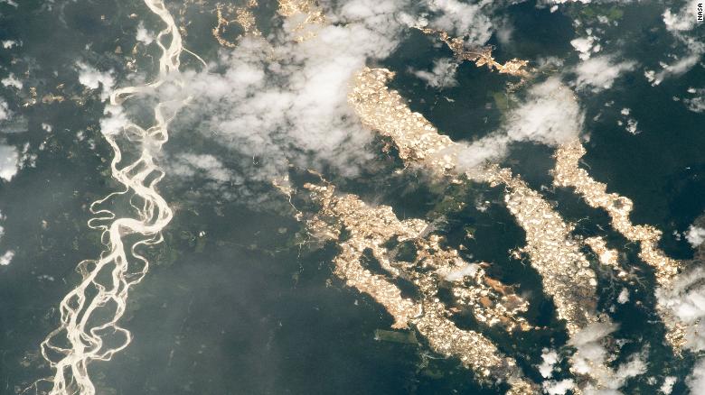
An image provided by the International Space Station has been circulating around the internet showing an aerial view of cascading ‘rivers of gold’ in the Peruvian Amazon. These fascinating ‘rivers’ are in fact destructive and toxic pits that form as a result of illegal gold mining activities. Though these pits are a common sight for our GIS team, many media companies and the subsequent public were shocked by this unusual sight, inspiring a wave of recent news articles from around the world.
With the increase in illegal gold mining in the Peruvian Amazon come deforestation, mercury poisoning to community water sources, and social conflicts including prostitution and forced labor. As the demand for gold continues to increase, this illegal practice has expanded farther and farther into sensitive Amazonian ecosystems.
However, we’re keeping an eye on these activities from above, and then use this information to aid authorities working on the ground down below. Satellite imagery company Planet published an article about how we were using data from satellite imagery to crack down on illegal gold mining. “The vastness of the Amazon can be a major challenge to its conservation, but technology, especially satellites, have emerged as an extremely powerful tool,” says Dr. Matt Finer, our Senior Research Specialist and Director of their Monitoring of the Andean Amazon Project (MAAP). “With the latest generation of satellites and related algorithms, we have been able to go from annual to more real-time monitoring. And it is this real-timeness that makes all the difference in linking this technology with effective policy action on the ground to reduce and avoid deforestation.”
MAAP aims to document the most urgent deforestation cases in near real-time and identify the direct causes of deforestation in the Andean Amazon. In doing so, MAAP is able to better understand larger-scale deforestation patterns, hotspots, and drivers. With this information, MAAP is able to improve policy and conservation action based on this cutting-edge technical information.
“Publishing this imagery is a new way to show the problem”, Matt Finer told Spanish news giant Agencia Efe. “It allows more people on a global scale to see it.”
 Loading...


