
MAAP #109: Fires and Deforestation in The Brazilian Amazon, 2019
September 10, 2019
The fires in the Brazilian Amazon have been the subject of intense global attention over the past month.
As part of our ongoing coverage, we go a step further and analyze the relationship between fire and deforestation in 2019.
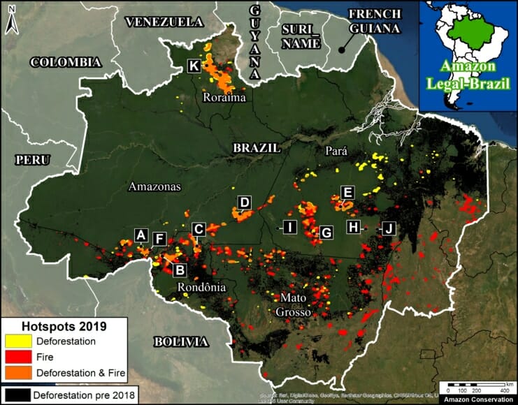
First, we present the first known Base Map showing both 2019 deforestation and fire hotspots, and, importantly, the areas of overlap. The letters correspond to Zooms below.
Second, we present a series of 16 high-resolution timelapse videos (Zooms A-K), courtesy of the satellite company Planet. They show five scenarios that we have documented thus far in 2019:
- Deforestation (No Fire)
- Deforestation (Followed by Fire)
- Agriculture Fire
- Savanna Fire
- Forest Fire
The key finding is that Deforestation (Followed by Fire) is critically important to understanding this year’s fire season (see Zooms B-E).
We documented numerous cases of 2019 deforestation events followed by intense fires, covering at least 52,500 hectares (130,000 acres) and counting. That is equivalent to 72,000 soccer fields.
The other common scenario is Agriculture Fire in areas cleared prior to 2019, but close to surrounding forest (see Zooms F and G).
We are also now seeing more examples of Savanna Fire in grassland areas among the rainforest. These fires can be large — we show a 24,000 hectare burn (60,000 acres) in Kayapó indigenous territory (see Zoom H).
We did not observe major Forest Fires in the moist Brazilian Amazon during August, but we did document such fires in early March in Roraima state. As the dry season continues into September and October, however, forest fires become a greater risk.
 Loading...


