2,321 Hectares Impacted By Mining Activity In Southern Napo
August 25, 2026
A new analysis by Fundación EcoCiencia and Amazon Conservation shows a sustained expansion of mining activity across five areas in the cantons of Tena and Carlos Julio Arosemena Tola. Between 2025 and the first quarter of 2026, satellite monitoring identified 580 hectares of newly affected land.
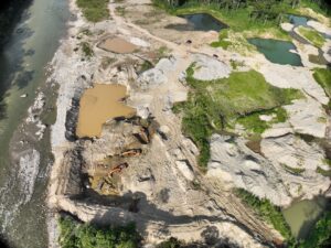 Within the framework of the Monitoring of the Andes Amazon Program (MAAP), Fundación EcoCiencia and Amazon Conservation have documented the continued growth of mining operations in the southern part of Napo province. Satellite data reveal 2,321 hectares affected by mining between January 2017 and March 2026 in five zones within the cantons of Tena and Carlos Arosemena Tola. Of that total, 580 hectares correspond to new mining activity detected during 2025 and the first quarter of 2026.
The report updates a previous assessment that had documented 1,741 hectares affected between 2017 and 2024. Through satellite monitoring, the new analysis examines five zones: the Jatunyacu, Anzu, and Huambuno rivers; the Puní–Cotona–Arajuno corridor; and a newly evaluated area along the Napo River near the communities of Sindy and San Carlos.
The findings reveal varying degrees of expansion across these monitored areas. The Anzu River shows the largest accumulated impact, reaching 806 hectares by March 2026, with roughly 13% of that area located outside the official mining cadastre. Along the Jatunyacu River, the affected area totals 561 hectares. In Huambuno, the impacted area reached 674 hectares as of March 2026, and approximately 23% of this activity occurs outside the mining cadastre.
One of the most notable developments is observed in the Puní–Cotona–Arajuno corridor, where the affected area increased from 112 hectares recorded up to January 2024 to 234 hectares by March 2026. In this corridor, 99% of the identified mining activity lies outside concessioned areas in the mining cadastre. During the first quarter of 2026 alone, the expansion exceeded 35% of the total area reported in 2025, underscoring a clear intensification of mining activity.
The report also identifies a new area of mining expansion along the Napo River, near the communities of Sindy and San Carlos. In this zone, the affected area grew from six hectares between 2023 and 2024 to 43 hectares in 2025, and 47 hectares by March 2026. Ninety‑four percent of this expansion lies outside the areas registered in the mining cadastre. Monitoring detected both small‑scale artisanal mining and larger operations using specialized machinery, including industrial classifier plants.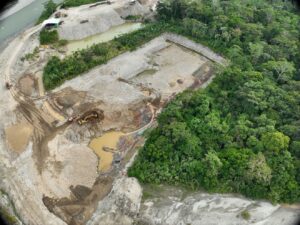
The analysis also documents several impacts associated with mining activity, such as the removal of forest cover, soil disturbance, changes in watercourses, erosion, and the formation of sedimentation pools. Along the Anzu River, interventions were identified near a petroglyph listed in the Ecuadorian Cultural Heritage Information System (SIPCE). Although no direct damage to the carving was observed, the report highlights the cultural sensitivity of the area and stresses the need to strengthen its protection.
In response to these findings, the report urges stronger monitoring, enforcement, and protection measures for the Napo River basin. It recommends integrating satellite imagery and drone surveillance with regular field inspections, community‑based monitoring, and sustained public oversight to ensure more effective control of mining activity.
Read the full report:
https://www.maapprogram.org/mining-ecuador-napo/
 Loading...