Image #1: Gold Mining Deforestation Continues To Expand In La Pampa (Madre De Dios, Peru)
March 26, 2015
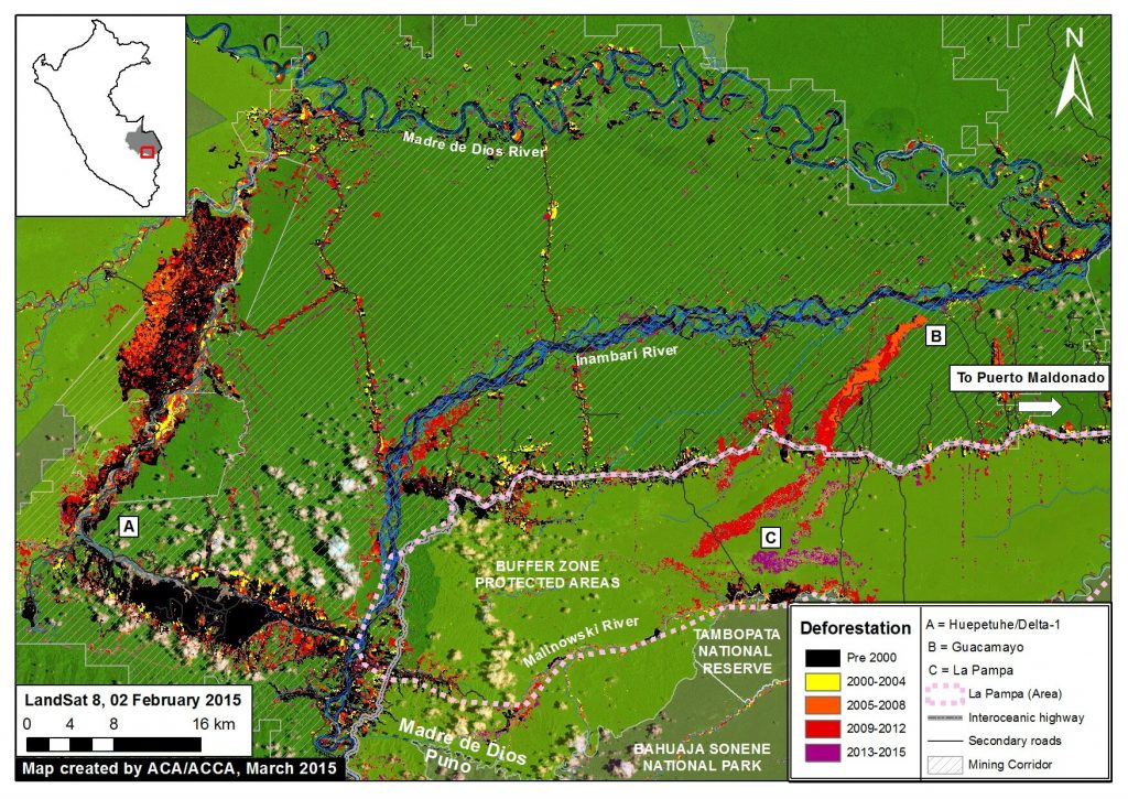
Image of the Week #1 highlights that gold mining deforestation continues to expand in the southern Peruvian Amazon (Department of Madre de Dios). Most notably, the image illustrates that much of the most recent (2013 – 2015) deforestation occured a) in an area known as La Pampa, b) outside of the legal mining corridor, and c) within the buffer zone of the Tambopata National Reserve.

Map Description:
Background map is a Landsat 8 image (30 m resolution) from February 2, 2015. Green indicates forest cover. Note there is some cloud cover. Data is from USGS.
Black indicates areas that were deforested as of 2000 according to data from the Peruvian Environment Ministry (MINAM 2009). Yellow, orange, and red indicate areas that were deforested from 2000 to 2012 (each color covers a four year period) (Hansen MC et al. 2013 Science 342: 850–53; Data download).
Purple indicates areas that were deforested between January 2013 and February 2015 based on our analysis of Landsat imagery using CLASlite forest monitoring software.
Data for secondary roads is from Conservación Amazónica-ACCA.
The mining corridor indicates the zone that the Peruvian Government has delimited as potentially legal for mining activities, but only if miners successfully complete a multi-step formalization process for each project. Data is from ACCA.
Protected areas data is from SERNANP. Dark green indicates established protected areas and light green indicates their buffer zones.
The majority of the forest loss shown on the map is associated with gold mining activity, although some is also associated with the recently paved Interoceanic Highway and its growing secondary roads network.
According to a recent study published in PNAS by Greg Asner et al., the gold mining deforestation in this region increased from 10,000 ha in 2000 to 50,000 hectares (ha) in 2012. This deforestation was concentrated in two primary areas: Huepetuhe/Delta-1 and Guacamayo (A and B on the map, respectively).
More recently, the deforestation has largely shifted to La Pampa (C on the map). This shift is particularly important because La Pampa is within the buffer zone of the Tambopata National Reserve and outside of the designated mining corridor. Using CLASlite, we detected 1,711 ha of deforestation in La Pampa between 2013 and 2015.
Zoom View of La Pampa

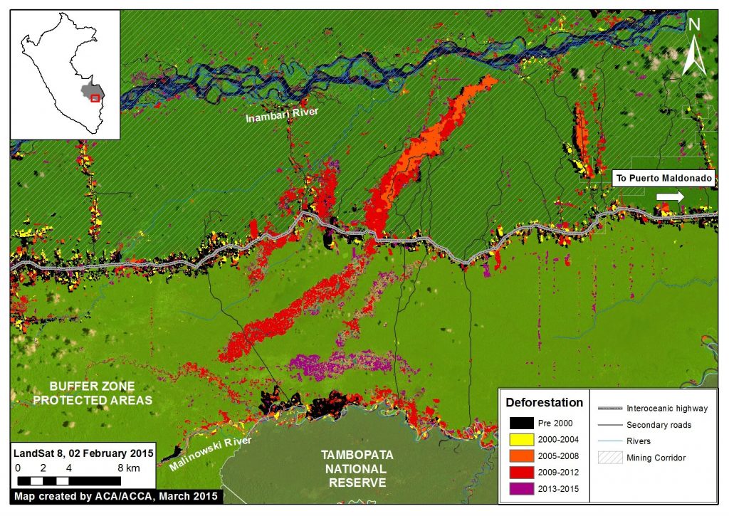
Image 2b is a zoom view of the La Pampa area provided to better illustrate the most recent deforestation within the Tambopata National Reserve buffer zone. As noted above, using CLASlite we detected 1,711 ha of deforestation within the La Pampa area between 2013 and 2015. That is the equivalent to more than 2,300 soccer fields.
Note that much of the most recent deforestation is within 6 km of the Tambopata National Reserve.
Near Real-time Monitoring

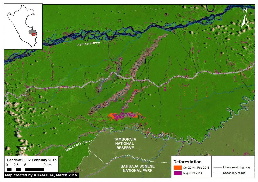
Thanks to a series of relatively cloud-free Landsat images, we were able to conduct near real-time analysis with CLASlite during 2014 and 2015.
For example, we found that between mid-October 2014 and early February 2015 (about four months) there was deforestation of 226.5 ha in La Pampa within the buffer zone of the Tambopata National Reserve. That is the equivalent to 310 soccer fields, a rate of over 2.5 fields a day.
Prior to that time period, we found that between mid-August and mid-October 2014 (abount nine weeks), there was deforestation of 431 ha in La Pampa.
Citation
Finer M, Novoa S (2015) Gold Mining Deforestation Continues to Expand in La Pampa (Madre de Dios, Peru). MAAP: Image #1. Link: https://maaproject.org/2015/03/gold-mining-deforestation-expand-peruvian-amazon/

 Loading...


