
Illegal Mining Is Once Again Pushing Deeper Into One Of Peru’s Most Iconic Protected Areas
May 12, 2026
- Satellite monitoring shows more than 500 hectares of forest lost and nearly a thousand people involved in illegal mining operating inside the Tambopata National Reserve.
- The advance of illegal mining continues, encroaching ever closer to government-run control posts within the protected area.
Seven years after the historic Operación Mercurio was launched, illegal gold mining has surged back inside the Tambopata National Reserve, one of the most important protected areas in the southern Peruvian Amazon.
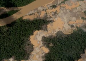
 A new high‑resolution satellite analysis by Conservación Amazónica–ACCA reveals a troubling resurgence of mining activity during the second half of 2025 and the early months of 2026. This renewed expansion has already resulted in the loss of 500 hectares of Amazonian forest within the reserve.
The findings are presented in the latest MAAP Report #241, which documents not only the scale of the environmental destruction but also the intensifying criminal pressure on an ecosystem that is critical to global biodiversity.
A resurgence surpassing even the most critical years
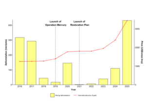
The data show that in 2025 alone, mining‑driven deforestation inside Tambopata exceeded 400 hectares, a figure that surpasses the levels recorded during the most critical years of illegal mining incursions, between 2016 and 2017.
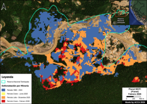
This new wave of expansion is concentrated primarily in the northern part of the reserve, in areas adjacent to the Malinowski River, a corridor long recognized as highly vulnerable to the entry of illegal operators.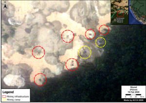
Using 0.5‑meter‑resolution Skysat satellite imagery, the technical team identified 183 active mining structures, 67 illegal camps, and five major mining hubs operating within the reserve.
Drawing on the detected infrastructure and ACCA’s previously developed models, the analysis estimates that around 1,000 people may currently be involved in illegal gold extraction inside the protected area.
Illegal mining advances near State-run control posts
One of the report’s most troubling findings is that mining activity is now expanding in areas close to several control posts inside the Tambopata National Reserve, including Otorongo, Azul, and Yarinal.
Satellite imagery reveals a clear pattern: the opening of new mining pits, the installation of heavy machinery, and the steady growth of illegal camps within the protected area.
The most affected zones include Isla Córdoba, with 106 hectares deforested, 53 mining pits, and 20 camps; A4, with 101 hectares impacted, 68 mining structures, and 33 camps; and Isla Correntada, where 111 hectares have been affected and active machinery and illegal camps remain visible.
“It is particularly alarming that a significant share of the illegal mining advance is taking place inside the reserve and in areas close to control posts. This greatly heightens the risks faced by the park rangers responsible for safeguarding the Tambopata National Reserve and underscores the urgent need for broader, more decisive measures to prevent potential situations of violence or confrontation on the ground,” said Sidney Novoa, Director of Conservation Technologies at Conservación Amazónica–ACCA.
What is driving the return of illegal mining?
The report points to a convergence of economic, institutional, and political factors behind this renewed expansion. A key driver is the sustained rise in international gold prices, which reached record highs in 2025 and significantly increased the profitability of illegal extraction.
 The analysis also warns that the current political and institutional climate may be enabling the resurgence of these illicit economies. Contributing factors include repeated extensions of the Reinfo registry, the weakening of regulations aimed at combating organized crime, the advancement of legislative proposals that could heighten extractive pressure on protected areas, and the budget constraints faced by the agencies responsible for oversight and enforcement.
Against this backdrop, the situation in Tambopata illustrates that enforcement operations alone are insufficient when environmental monitoring, regulatory oversight, and organized‑crime prevention mechanisms are being eroded. “Protecting natural protected areas requires regulatory stability, a sustained and effective State presence, and comprehensive measures that reduce the incentives currently fueling the expansion of these illegal economies,” said Gaby Rivandeneyra, Project Lead at DAR and representative of the Illegal Mining Observatory (OMI, the acronym in Spanish).
Enforcement operations fall short of stopping the advance
Between January and March 2026, joint operations involving law‑enforcement agencies, environmental prosecutors, and other competent authorities succeeded in seizing and destroying machinery, fuel, engines, and camps linked to illegal mining.
However, satellite monitoring shows that, despite these interventions, the activity continues across the area.
This underscores a widening gap between the State’s operational response capacity and the speed with which criminal networks are able to reorganize and resume operations.
“The situation in the Tambopata National Reserve is emblematic for the entire Amazon. It shows that committed governments can confront illegal mining, but that the activity can return quickly if that commitment weakens,” said Matt Finer of Amazon Conservation.
A threat to biodiversity and to those who defend it
 The Tambopata National Reserve protects some of the most biodiverse ecosystems on Earth. Yet the advance of illegal mining threatens not only its forests and waterways, but also the people who risk their safety to defend this territory.
Amid rising violence against environmental defenders in Madre de Dios, the report’s findings show that this new expansion is driven not only by criminal networks, but also by a deepening erosion of environmental governance.
Today, Tambopata is once again confronting a threat that puts decades of conservation efforts in the Peruvian Amazon to the test.
You can read the full report here:
https://www.maapprogram.org/mining-peru-tambopata/
————————————————————————————————————————-
About the report
MAAP Report #241 was prepared by the Amazon Conservation’s Monitoring of the Andean Amazon Project (MAAP), in partnership with Conservación Amazónica–ACCA, leading this report. The analysis draws on high‑resolution satellite imagery, historical geospatial datasets, and a review of the political and institutional context surrounding illegal gold mining in the Peruvian Amazon.
 Loading...


