New road between Acre and Peru could cause up to 133,000 hectares of deforestation in the Amazon rainforest, study finds
September 30, 2026
New analysis assesses the impacts of BR-364 expansion on Acre’s forests and warns of risks to REDD+ investments and the communities that depend on these resources
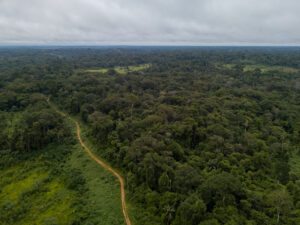
 A new analysis of planned road infrastructure expansion in Acre estimates that a paved international road between the Brazilian state and Pucallpa, Peru, could cause approximately 74,700 hectares of additional deforestation over ten years and 133,800 hectares over twenty years, beyond the losses projected from paving BR-364.
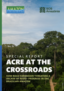
The report, “Acre at the Crossroads: How Road Expansion Threatens a Decade of REDD+ Progress in the Brazilian Amazon”, prepared by researchers from Amazon Conservation and SOS Amazônia, analyzes three infrastructure scenarios and uses as a historical reference the impacts observed along BR-317, the Interoceanic Highway, following its international connection with Peru.
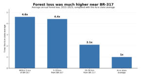
Between 2011 and 2023, Acre’s average annual forest loss rate was 0.58%. In areas within five kilometers of BR-317, the rate reached 2.67% per year, 4.6 times the state average. Between five and 20 kilometers from the road, the rate was 2.54%, or 4.4 times the Acre average, while areas between 20 and 50 kilometers experienced a rate of 1.22%, or 2.1 times the state average.
Based on this historical experience, researchers estimated the impacts on forest areas that would become more accessible under different road expansion scenarios. Paving BR-364 between Rio Branco and Cruzeiro do Sul, combined with improvements to the connection with Porto Walter, could be associated with an additional 857,400 hectares of deforestation over ten years. With a new international road to Pucallpa, the projection reaches 932,100 hectares over the same period. The difference between the two scenarios is approximately 74,700 hectares over ten years and 133,800 hectares over twenty years.
These figures should not be interpreted as precise forecasts. Actual outcomes would depend on several factors, including enforcement and the management of protected areas along road corridors.
Environmental and economic gains at risk
Over the past two decades, Acre has built one of the world’s most established jurisdictional REDD+ programs. REDD+ stands for Reducing Emissions from Deforestation and Forest Degradation and is a mechanism designed to reward countries and jurisdictions for avoiding emissions associated with forest loss.
Since 2012, the REDD+ Early Movers (REM) program, an initiative that rewards verified emission reductions, has provided the state with approximately €56 million, equivalent to R$331 million, for around 21 million tons of verified emission reductions.
In 2025, Acre also signed a presale agreement with Standard Chartered Bank for credits corresponding to up to 40 million tons of emission reductions, with the potential to generate up to US$150 million in carbon credit revenue. The state’s Benefit Sharing Plan allocates 72% of net revenues from the sale of these credits to forest communities.
Maintaining this flow of resources is directly linked to continued reductions in deforestation. Projections presented by the state indicate the potential to generate up to US$1.83 billion between 2023 and 2027 from the sale of credits issued under TREES, the Architecture for REDD+ Transactions’ REDD+ Environmental Excellence Standard. These figures depend on both continued reductions in deforestation and demand in the voluntary carbon market.
“There is a tension between Acre’s existing REDD+ commitments and progress on reducing deforestation and the new risks associated with road expansion. Some of that new infrastructure is rightly needed but its impact in terms of putting additional forest cover at risk will need to be managed carefully. Some of these infrastructure projects, like the connection between Cruzeiro do Sul and Pucallpa, don’t stand the test of reason. After decades investing in a vision that sees Acre’s forests preserved, some consistency is needed.” says Blaise Bodin, Director of Policy and Strategy at Amazon Conservation.
Regional integration with forest protection
The analysis highlights the importance of infrastructure for Acre’s population and the economic and social benefits of regional integration, particularly in hard to reach areas, while emphasizing the need to incorporate medium and long term environmental and climate impacts into planning, with adequate impact assessment, licensing, monitoring, and enforcement.
 In the case of the proposed connection to Pucallpa, economic evidence included in the report also raises questions about the project’s viability. A 2022 assessment published by Conservation Strategy Fund calculated a negative net present value for both the Peruvian and Brazilian sections of the connection, with an internal rate of return below zero in both cases.
The MAP region, which encompasses Madre de Dios in Peru, Acre in Brazil, and Pando in Bolivia, contains more than 54 million hectares of relatively intact forest and communities with extensive experience in forest management. In Acre alone, the sustainable production of non timber forest products could generate up to US$71 million in net annual revenue while maintaining forest cover.
The Port of Chancay in Peru also expands opportunities to access Asian markets for products from the Amazon forest economy, including açaí, Brazil nuts, certified timber, and ingredients for the cosmetics and pharmaceutical industries.
Daniela Dias, Leader of The Protected Areas and Biodiversity Conservation Program at SOS Amazônia, remarks that “Acre has great potential to consolidate its existing climate policy by integrating different sectors around a development model that values standing forests. This is not about choosing conservation over development, but about strategic action to safeguard territorial integrity while creating sustainable economic opportunities through a model of bioeconomy based on local knowledge, REDD+ and environmental services.”
About the study
“Acre at the Crossroads: How Road Expansion Threatens a Decade of REDD+ Progress in the Brazilian Amazon” examines the potential impacts of road infrastructure expansion in Acre on deforestation, the state’s climate commitments, and REDD+ related revenues. The modeling compares three infrastructure scenarios and uses historical data from BR-317 as a reference to estimate the risks associated with the expansion of BR-364 and a potential international connection to Pucallpa, Peru. The study was prepared by researchers from Amazon Conservation in partnership with SOS Amazônia.
Read the full report: https://www.amazonconservation.org/publication/
 Loading...