
Report Shows Illegal Mining Has Declined In The Yanomami Indigenous Territory, But Invaders Are Shifting Tactics To Stay Active
May 22, 2026
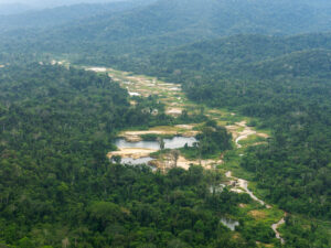
Illegal mining–driven deforestation reached its peak in 2022, when roughly 1,800 hectares were cleared. In 2025, monitoring still identified an additional 45.2 hectares of new forest loss.
 Deforestation driven by illegal mining in the Yanomami Indigenous Territory has dropped sharply over the past three years, following a surge in 2021 and 2022. That’s the conclusion of a new report released this Friday (May 22) by the Instituto Socioambiental (ISA), in partnership with MAAP (Monitoring of the Andes Amazon Program), an initiative of the Amazon Conservation Association.
According to the report, satellite mapping suggests that invaders have changed the way they operate in response to increased enforcement, adopting more decentralized tactics and moving toward areas closer to the Venezuelan border. These findings are reinforced by complaints recorded in the Yanomami Indigenous Territory Alert System, which show that both aerial and river‑based incursions continue.
According to the report, the Yanomami Indigenous Territory has accumulated 5,564 hectares of land degraded by illegal mining. The material produced by ISA and the Amazon Conservation Association was developed in partnership with the Hutukara Associação Yanomami (HAY) and the Associação Wanasseduume Ye’kwana (Seduume).
In 2025, 45.2 new hectares were deforested as a result of illegal mining in the territory, nearly half of the 84 hectares recorded in 2024. According to the report, this figure is a warning sign: despite the slowdown in mining activity, the opening of new areas shows that the illegal operations have not been fully neutralized.
In 2023, when the Federal Government declared a Public Health Emergency of National Importance in the territory, 330 hectares of expansion were recorded – an 81.6% reduction compared to the previous year.
In 2020, 400 hectares were deforested, and in 2021 the figure rose to more than 1,000 hectares. The year 2022 saw the largest increase, with approximately 1,800 hectares cleared.
This monitoring is carried out monthly through the visual interpretation of satellite images by geoprocessing specialists. Based on these images, degradation polygons are drawn. Each month, the affected areas are revisited to refine the mapping and check for possible errors.
New areas impacted
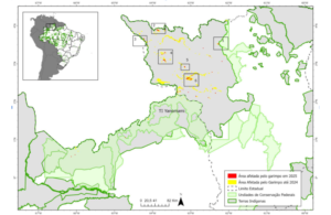 In 2025, the mapping identified 121 polygons of newly impacted areas linked to illegal mining, 90% of them measuring one hectare or less. The two largest polygons – each roughly four hectares – are located in the Parima and Surucucus regions, specifically near the Feijão Queimado airstrip in Roraima.
The report also notes that illegal miners have dispersed their activities, avoiding the large concentrations seen before federal operations began. Areas previously exploited to exhaustion, such as Alto Catrimani, Médio Uraricoera and Homoxi, now appear to be relatively neutralized.
New tactics
To evade enforcement, the invaders continue relying on the tactic of moving toward areas closer to the Venezuelan border. In this context, the report identified new scars in Parafuri‑Parima, Hokomawë and Cabeceira do Aracaçá.
In 2025, the Yanomami Indigenous Territory Alert System – created and used by organizations within the Yanomami Territory – recorded at least five alerts related to the movement of clandestine aircraft in the Auaris region. In most cases, the aircraft were flying toward Hokomawë, either in the direction of the Gaúcho Animal airstrip, located at the mouth of the Auaris River, or toward the airstrip at the headwaters of the Aracaçá River.
According to ISA geographer Estêvão Senra, with gold prices reaching historic highs on the international market, pressure from illegal mining remains constant.
“Eviction operations are an essential first step, but on their own they do not solve the structural problem. Without medium‑ and long‑term territorial protection strategies – including permanent surveillance and improvements in the regulation of the gold supply chain – there is a significant risk of seeing a new wave of invasions in the near future.”
The same pattern has been observed in other parts of the Amazon where eviction and enforcement operations have taken place, such as the Madre de Dios region in Peru, which destroyed more than 100 mining dredges in recent years. Now, satellite data show the return of incursions into protected areas, including the Tambopata National Reserve, according to a recent report also released by MAAP.
Matt Finer, director of the MAAP program at Amazon Conservation, emphasizes that the data show governments are capable of reducing illegal mining when coordinated interventions and effective enforcement efforts are in place. “In the Yanomami Indigenous Territory, illegal mining reached its peak between 2021 and 2022 but dropped significantly after the major intervention by the Brazilian government beginning in 2023. However, as we have recently observed in Peru and Venezuela, these actions must be part of a continuous, long‑term effort. Otherwise, illegal mining tends to return quickly.”
Territorial Alerts
In 2025, the alert system recorded a total of 66 territorial alerts. Of these, 83% were invasion alerts, which include information on the movement of clandestine aircraft, boats, barges and other vehicles. There were also reports of attacks and the entry of firearms.
The alert system is an initiative of the organizations of the Yanomami Indigenous Territory: Hutukara Associação Yanomami, Associação Wanasseduume Ye’kwana, Urihi Associação Yanomami, Parawamë, Kurikama, AYRCA and Kumirayoma, with technical support from ISA and backing from the United Nations Children’s Fund (Unicef). The tool began to be implemented in 2023.
Read also Yanomami Indigenous issue cell phone alerts to defend their territory
The system allows community monitors to send alerts through a form with photos, videos, audio recordings and geolocation, even offline. The information is validated and translated by Indigenous researchers, organized into a public dashboard, and forwarded to the authorities. The tool is available in four languages: Yanomami, Ye’kwana, Sanoma and Portuguese.
Among the regions that recorded alerts of airspace invasion, in addition to Auaris, are Xitei, Alto Catrimani and Apiaú (possibly linked to mining activity on the Couto Magalhães River).
“In the case of Catrimani, the link between this movement and the mining activity taking place at the headwaters of the Orinoco, in Venezuelan territory, one of the areas with the highest miner activity in recent years, is striking,” the report notes.
The Taboca airstrip, located in Venezuela, is identified as a strategic part of the logistics that sustain illegal mining in Brazil. The airstrip supports invaders who continue to operate in the Alto Catrimani and Xitei regions.
According to the report, the Ericó region, an area accessible via the Uraricaá River, showed significant signs of deforestation linked to mining activity. During the most critical phase of the invasion, there were reports of dredges operating on the Uraricaá River, but no signs of mining on land. That scenario appears to have changed as part of the invaders’ strategy to evade operations in more heavily monitored areas.
Alerts submitted through the system also indicate the persistence of incursions along the Uraricoera, Catrimani, Apiaú and Ajarani rivers. Reports include barge traffic, dredge operations, the transport of cassiterite and the entry of supplies into mining camps.
Baixo Catrimani is the region that reported the highest number of river‑based invasions. From April to December 2025, the Yanomami sent nine alerts about the presence of barges, dredges and the movement of suspicious boats.
 Loading...


