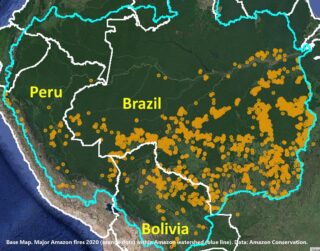
As presented in MAAP #118, Amazon Conservation launched a real-time fire monitoring app that specializes in the rapid and user-friendly detection and visualization of major Amazon fires. In a novel approach, the app combines data from the atmosphere (aerosol emissions in smoke) and the ground (heat anomalies) to effectively monitor large Amazon fires. As detailed below, the app just […]
Fire Alert vs. Aerosol Emission Data Images 1 and 2 shows us how aerosol emission data allows users to prioritize hundreds (or thousands) of heat-based fire alerts. In other words, the aerosol data indicates just the fires that are actually burning lots of biomass and putting out abundant smoke.
As presented in MAAP #118, Amazon Conservation launched a real-time fire monitoring app that specializes in detection of elevated aerosol emissions in the smoke coming from burning Amazon fires. As detailed below, the app just detected the fourth major Amazon fire of 2020 on June 17. All four fires thus far have been in the state of Mato Grosso and […]
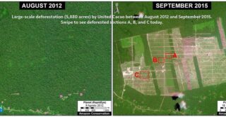
WASHINGTON, DC, June 5 – Amazon Conservation revealed in a new report the ability to predict the exact location of major 2020 fires in the Brazilian Amazon, using deforestation data. The fires in the Brazilian Amazon made international headlines last year. Through analysis of satellite imagery archives, Amazon Conservation made the significant discovery that many fires […]
WASHINGTON, DC, June 10 – Amazon Conservation today announced the launch of a new real-time fire monitoring app, hosted by Google Earth Engine, in anticipation of the 2020 fire season. The app specializes in providing real-time detection and prediction of large fires across the Amazon basin to help prioritize containment efforts by key actors on […]
Following up on the current fires in the Amazon forests of Brazil, Bolivia, and Peru, we want to share with you our latest analysis of the situation. Please see today’s MAAP report, which provides real-time satellite data of the region and shows up-close satellite images of what the fires actually look like across all three countries, […]
The fires in the Amazon rainforest of Brazil and Bolivia have been burning for three weeks now. Thousands of acres of forests have been lost. Although Amazon Conservation cannot stop the current fires from happening – at this point, only national and local authorities can – we can help prevent them from happening. We are doing […]
Earlier this year, the government of Peru launched a multi-sectoral and comprehensive mega-operation aimed at eradicating illegal mining and associated crime in La Pampa, Peru, called Operation Mercury. The operation came about in part after Amazon Conservation, through our real-time monitoring program, provided the Peruvian government with key information on the location of illegal mining camps […]
Through Amazon Conservation’s Monitoring of the Andean Amazon Project (MAAP), we identify, analyze, track, and publicize deforestation taking place in the Amazon in real-time using high-tech, satellite imagery. We use this information to make local authorities, policymakers, and the general public aware of what is happening on the ground. Recently, we conducted an in-depth analysis of […]
Our Boots on the Ground Approach We focus our work on the headwaters of the Amazon in Peru and Bolivia, as threats and damage to this key area trickles down and affects the entirety of the Amazon in other countries. We have been working in the field in these two countries for two decades now, […]