Peru recently celebrated a major conservation victory for 2015 with the creation of Sierra del Divisor National Park. Prior to this announcement, Sierra del Divisor was classified as a Reserved Zone, which is a temporary measure to protect an area of biological importance until the government is able to determine a final designation. In these cases, national park status represents the strongest possible final designation.
Now in 2016, there is the opportunity for another major conservation victory in Peru: creation of Yaguas National Park. Yaguas received Reserved Zone status in 2011 and is now awaiting its final designation. Yaguas Reserved Zone is both big (868,928 hectares or 2,147,168 acres) and remote, located in extreme northeast Peru within the department of Loreto (see Image 22a).
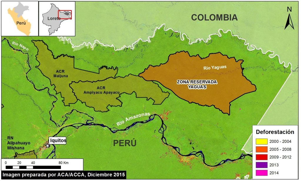
Image 22a. Yaguas Reserved Zone. Data: USGS, SERNANP, PNCB/MINAM, Hansen/UMD/Google/USGS/NASA
Note that Yaguas is a critical part of a series of protected areas that provide landscape level biological connectivity in northeast Peru. In addition, Yaguas borders and complements a large protected Colombian landscape, forming one of the largest assemblies of protected areas and indigenous lands in the Amazon.
Deforestation Analysis
Yaguas Reserved Zone is the rare example of an area in extremely good conservation condition. As seen In Image 22b, we detected virtually no deforestation within or surrounding the reserve. Note that the background in Image 22b is a Landsat image (30 m resolution) from December 2015 showing the reserve is completely covered with intact forest.
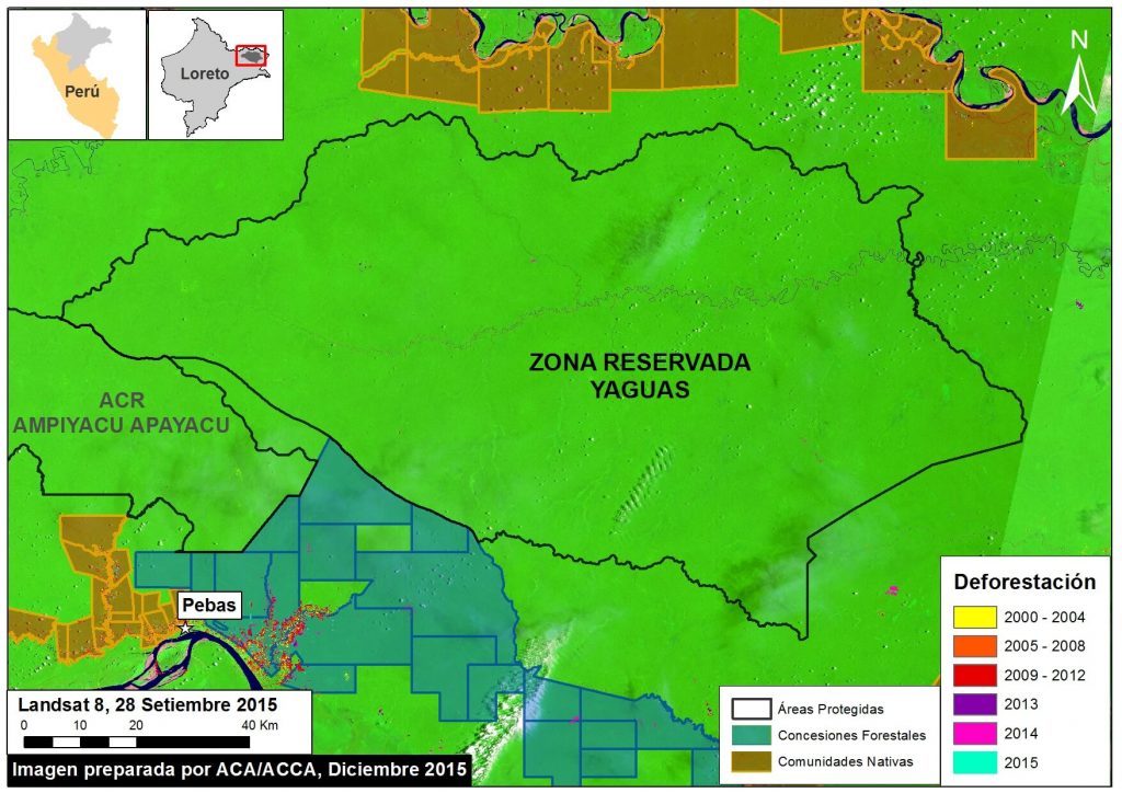
Image 22b. Yaguas Deforestation analysis. Data: USGS, PNCB/MINAM, Hansen/UMD/Google/USGS/NASA, MINAGRI, SERNANP
Carbon Analysis
Dr. Greg Asner (Carnegie Institution for Science) and the Peruvian Ministry of the Environment recently produced a high-resolution carbon map of Peru (Asner et al. 2014 a,b). As seen in Image 22c, much of the reserve contains very high carbon levels. Using this data, we calculated that Yaguas Reserved Zone contains approximately 102 million metric tons of above-ground carbon, one of the highest totals for a protected area in all of Peru.
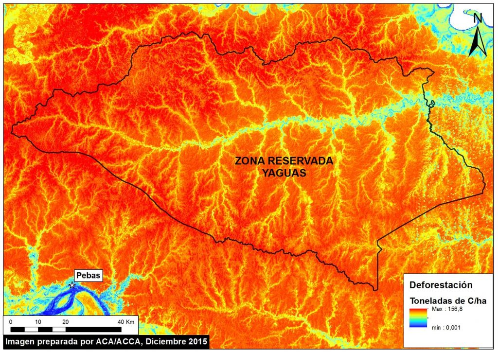
Image 22c. High-resolution carbon geography of the Yaguas Reserved Zone. Data: Asner et al. 2014 a,b.
Asner GP, Knapp DE, Martin RE, Tupayachi R, Anderson CB, et al. (2014 a) Targeted carbon conservation at national scales with high-resolution monitoring. Proceedings of the National Academy of Sciences, 111(47), E5016-E5022.
Asner GP, Knapp DE, Martin RE, Tupayachi R, Anderson CB, et al. (2014 b) The high-resolution carbon geography of Peru. Berkeley, CA: Minuteman Press.
Biodiversity
The Yaguas Reserved Zone also contains extremely high levels of biodiversity, particularly for fish. In fact, according to a rapid biological inventory by the Field Museum in 2010, Yaguas may be home to the highest fish diversity in Peru. During the inventory, scientists recorded 337 fish species in three weeks, far more than any other rapid inventory in Peru (see Image 22d). Biologists estimate that Yaguas is home to around 550 fish species, making it one of South America’s most diverse aquatic ecosystems.
The Reserved Zone (and proposed national park) was specifically designed to protect this extraordinary aquatic diversity. It contains a complete gradient of lowland river aquatic habitats, from headwaters (first order and intermediate) and springs to lowland areas encompasing habitats such as floodplains, lakes, swamps, bogs, and a meandering main river (see Images 22e and 22f). Importantly, unlike most of the major rivers protected by Peruvian national parks, the Yaguas River is born in the Amazon lowlands, not in the Andes. Thus, it contains hydrological processes and riparian habitats that are not yet strictly protected by the Peruvian system of protected areas.
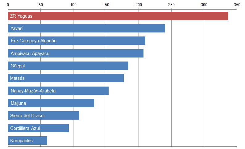
Image 22d. Number of fish species recorded in rapid inventories of the Yaguas Reserved Zone and 10 other sites in Loreto, Peru. Data: http://fm2.fieldmuseum.org/rbi/results.asp
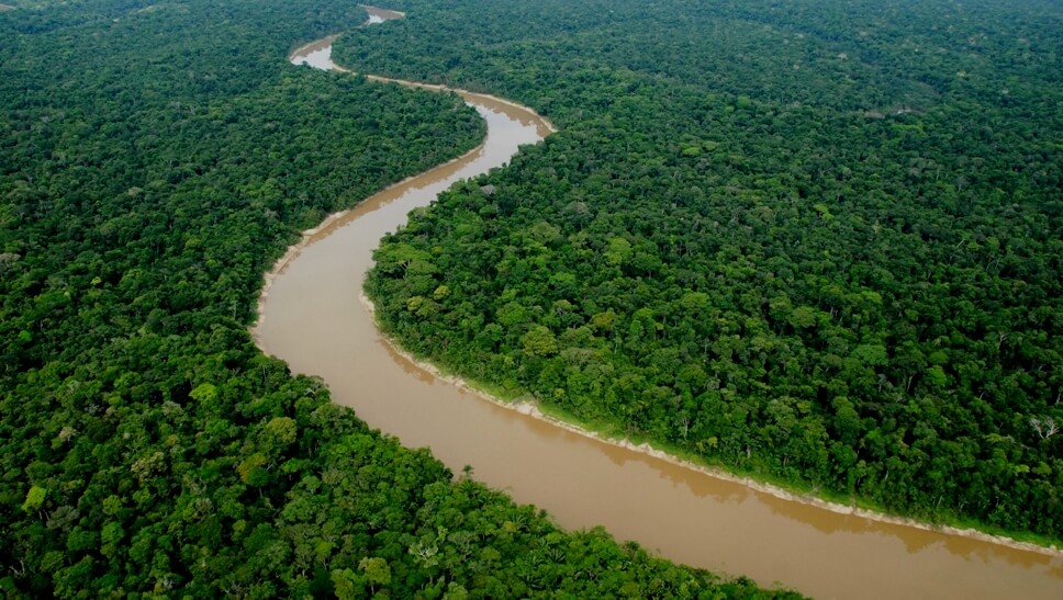
Image 22e. Aerial view of Yaguas River. Photo Credit: Alvaro del Campo (Field Museum)
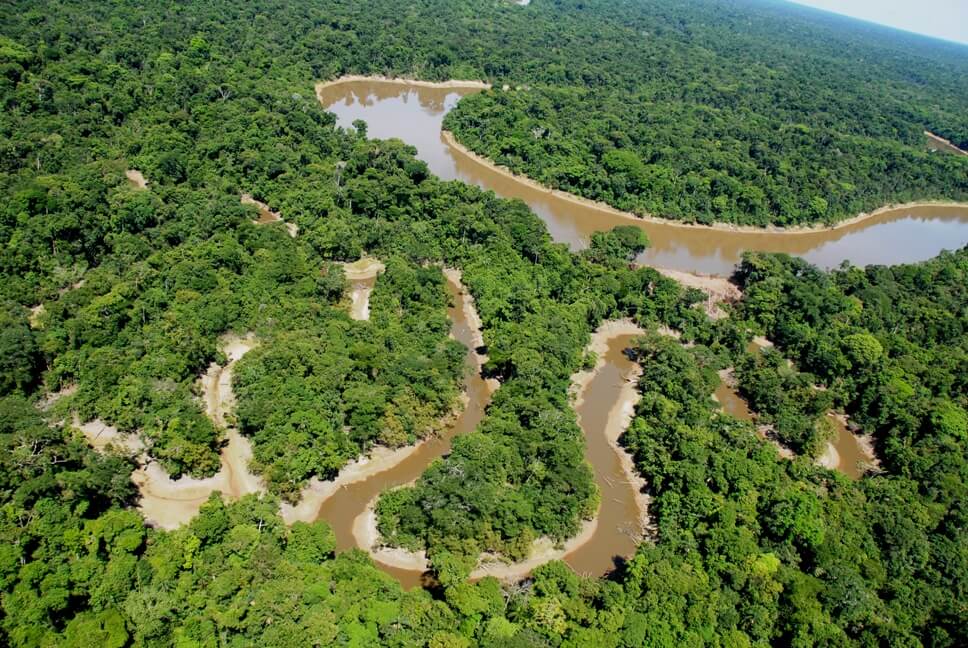
Image 22f. Aerial view of Yaguas River and the Cachimbo tributary. Photo Credit: Alvaro del Campo (Field Museum)
References:
Hidalgo, M. H., y A. Ortega-Lara. 2011. Peces. Pp. 98–108 y 308–329 en N. Pitman, C. Vriesendorp, D. K. Moskovits, R. von May, D. Alvira, T. Wachter, D. F. Stotz y Á. del Campo, eds. Perú: Yaguas-Cotuhé. Rapid Biological and Social Inventories Report 23. The Field Museum, Chicago. http://fm2.fieldmuseum.org/rbi/results_23.asp
Pitman, N., C. Vriesendorp, D. K. Moskovits, R. von May, D. Alvira, T. Wachter, D. F. Stotz y Á. del Campo, eds. 2011. Perú: Yaguas-Cotuhé. Rapid Biological and Social Inventories Report 23. The Field Museum, Chicago. http://fm2.fieldmuseum.org/rbi/results_23.asp
Acknowledgments
We thank the Field Museum and Instituto del Bien Común for helpful comments and information.
Citation
Finer M, Novoa S (2015) Another Big Conservation Opportunity for Peru: Yaguas.



 Loading...


