Two Ancient Icons of the Neotropics

The Harpy Eagle (Harpia harpyja) and the Shihuahuaco tree (Diptheryx micrantha) are iconic species of the Neotropics that play key roles in the health of the ecosystem.

The harpy eagle is the heaviest and most powerful raptor inhabiting the canopy of rainforests. Its historic distribution ranges from southern Mexico to northeastern Argentina. While the variety in its diet suggests an opportunistic foraging behavior, it feeds mostly on arboreal mammals.

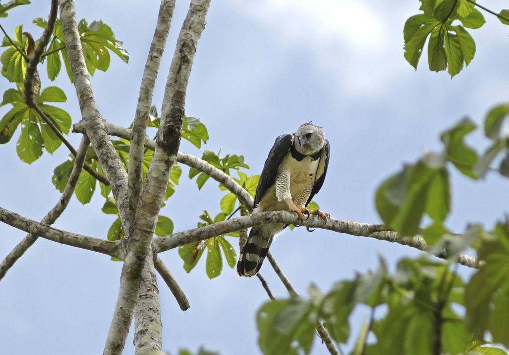
The mighty harpy eagle (Hapia harpyja) occasionally needs a break. Picture taken at Los Amigos Birding Lodge. PC: Rich Hoyer

Already hard to spot in the wild due to hunting and habitat loss, the harpy eagle population has plummeted in many countries of Central America.  An obstacle to its recovery is its slow reproductive rate: the eagle generally breeds every two to three years, with a single offspring per nesting effort.

A single shihuahuaco (Diptheryx micrantha) tree might sequester a third of all carbon stored in a hectare of primary forest. PC: Gianella Espinosa – Arbio

The shihuahuaco, meanwhile, is an emergent tree of the canopy that can reach a height of over 50 meters. It is patchily distributed in South America from Colombia to Bolivia. Shihuahuaco seeds and fruits are a source of food for species such as bats, agoutis, macaws, and hawks.

The slow-growing shihuahuaco can take centuries to reach its maximum height. Though not classified as endangered, it is critically threatened by logging and deforestation. In Peru, due to its hard wood and resistance to rot, the shihuahuaco is one of the most exported timber species, both legally and illegally.

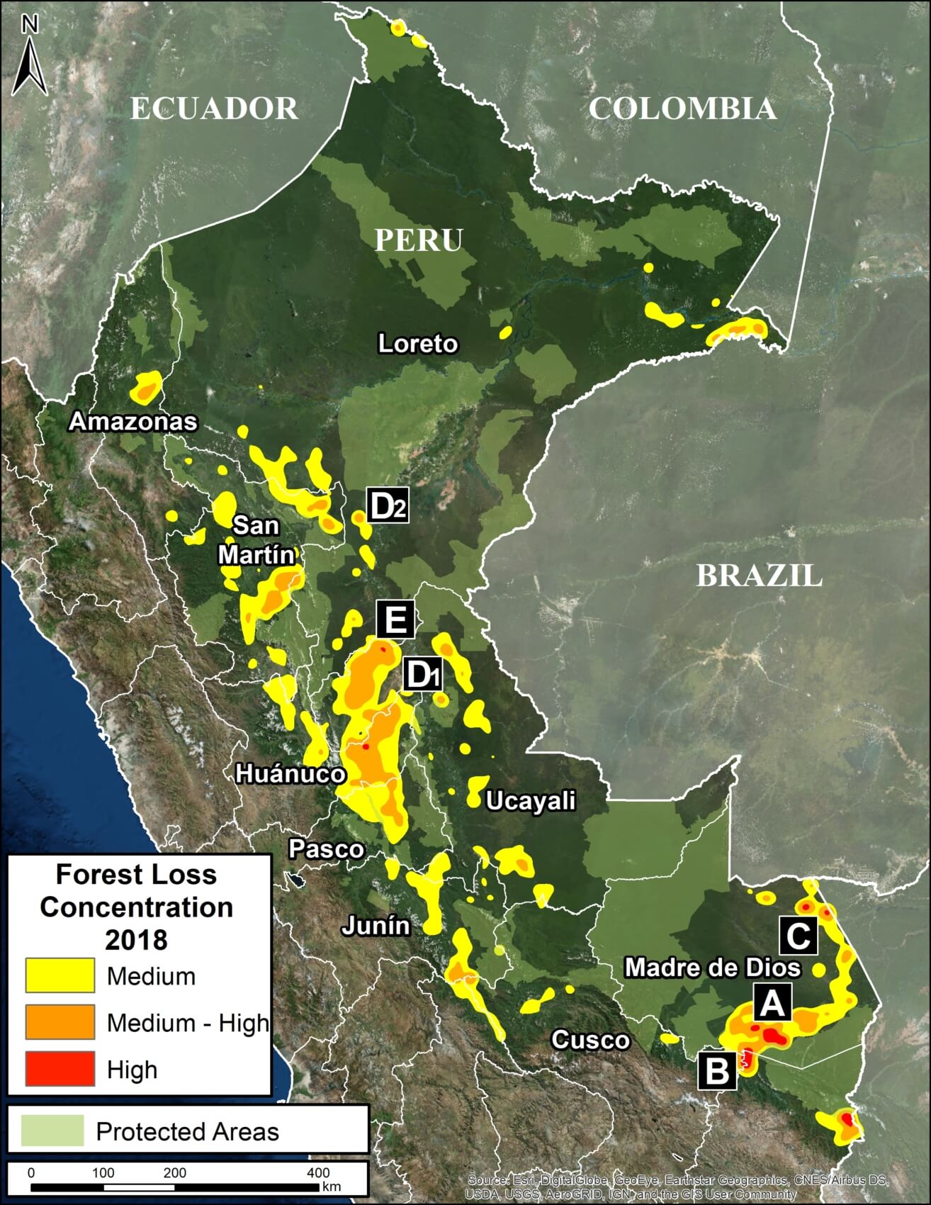
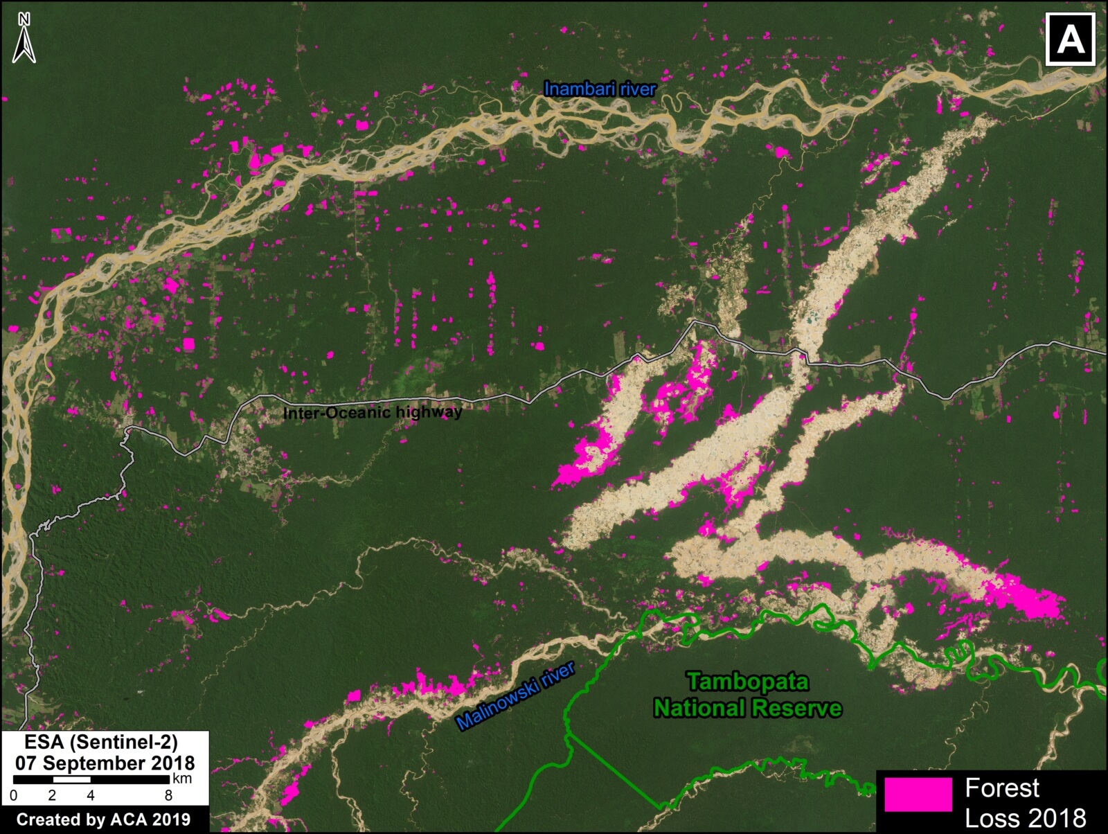
Deforestation is the two species’ common destroyer: it has decreased the availability of prey and nesting sites for the eagle, while reducing disperser populations and suitable habitat for the shihuahuaco.

In a forest, the absence of large predators is associated with decreased tree diversity. The harpy eagle helps controls the presence of herbivores and thus enables many tree species to propagate. While standing, the shihuahuaco is an ecologically important species due to its broad buttresses that give structural integrity to the forest; when it falls, it leaves large gaps, facilitating successional forest growth. Further, because of the large amount of carbon a single shihuahuaco tree can store, it is a key species to fight the effects climate change.

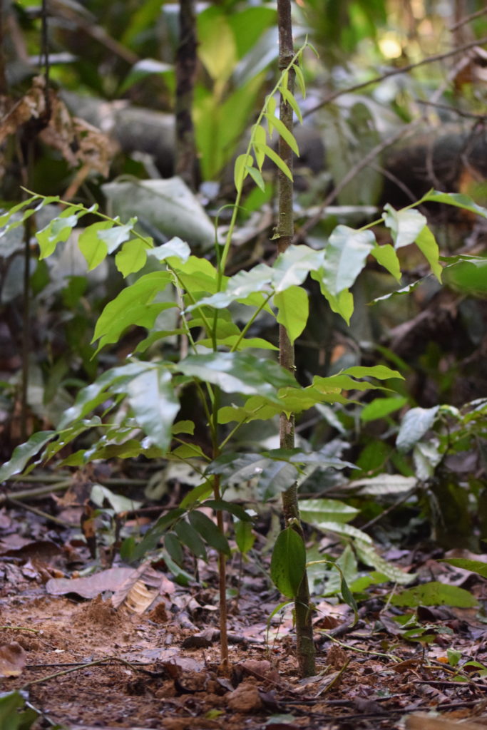
One of the many shihuahuaco (Diptheryx micrantha) seedlings being planted throughout the station. PC: Arianna Basto

Because of its great size, for nesting, the harpy eagle depends on emergent trees of the canopy, one of the most important being the shihuahuaco. Locals and researchers have described the close relationship between these two species. Notably, eagle nests built on shihuahuaco branches will serve for more than one reproductive season.

At Los Amigos, we are planting over a hundred shihuahuaco seedlings. Eventually, the shihuahuaco will be a common sight here… and, with luck, so will the majestic eagle.

Further reading:

  • Aguiar-Silva, F. H., Sanaiotti, T. M. & Luz, B. B. (2014). Food Habits of the Harpy Eagle, a top Predator from the Amazonian Rainforest Canopy. Journal of Raptor Research, 48(1): 24-35. URL: https://doi.org/10.3356/JRR-13-00017.1
  • Putzel, L., Petersa, C. M. & Romod, M. (2011). Post-logging regeneration and recruitment of shihuahuaco (Dipteryx spp.) in Peruvian Amazonia: Implications for management. Forest Ecology and Management 261 (2011) 1099–1105. doi:10.1016/j.foreco.2010.12.036

MAAP #98: Deforestation Hotspots In The Peruvian Amazon, 2018

Base Map. 2018 Deforestation Hotspots. Data: PNCB/MINAM, SERNANP

Thanks to early warning forest loss alerts,* we are able to make an initial assessment of the 2018 deforestation hotspots in the Peruvian Amazon.

The Base Map highlights the medium (yellow) to high (red) hotspots. In this context, hotspots are the areas with the highest density of forest loss alerts.

Note that the most intense hotspots are concentrated in the southern Peruvian Amazon, particularly the Madre de Dios region. In previous years, intense hotspots were also concentrated in the central Peruvian Amazon.

Next, we focus on 5 hotspots of interest (Zooms A-E).

A. La Pampa (Madre de Dios)
B. Bahuaja Sonene National Park (surroundings) (Madre de Dios, Puno)
C. Iberia (Madre de Dios)
D. Organized Deforestation (Ucayali, Loreto)
E. Central Amazon (Ucayali, Huánuco)

*The data presented in this report is an estimate based on early warning data generated by the National Program of Forest Conservation for the Mitigation of Climate Change of the Ministry of the Environment of Peru (PNCB/MINAM). We also analyzed University of Maryland GLAD alerts, obtained from Global Forest Watch.

A. La Pampa (Madre de Dios)

Zoom A shows two important cases in the southern Peruvian Amazon (Madre de Dios region). First, gold mining deforestation south of the Interoceanic Highway in the area known as La Pampa. It is important to emphasize that the Peruvian government just started “Operation Mercury 2019” (Operación Mercurio 2019), a multi-sectoral and comprehensive mega-operation aimed at eradicating illegal mining and associated crime in La Pampa, as well as promote development in the region. Second, deforestation due to agricultural activity north of the highway. As in all the zoom maps below, pink indicates forest loss in 2018.

Zoom A. La Pampa. Data- PNCB:MINAM, SERNANP, ACCA, ESA

B. Bahuaja Sonene National Park (surroundings) (Madre de Dios, Puno)

Zoom B also shows two important cases in the southern Peruvian Amazon (regions of Madre de Dios and Puno), surrounding Bahuaja Sonone National Park. First, to the north of the park, is gold mining deforestation along the upper Malinowski River. The Peruvian protected areas agency (SERNANP) points out that they have limited the deforestation south of the river (direction towards the national park) due to their intensified patrols on that side. Second, to the south of the park, is non-mining (partly agricultural) deforestation.

Zoom B. Bahuaja Sonene (surroundings). Data- PNCB:MINAM, SERNANP, Planet


C. Iberia (Madre de Dios)

Zoom C takes us to the other side of Madre de Dios, around the town of Iberia, near the border with Brazil and Bolivia. This area is experiencing extensive deforestation due to agricultural activity. There most intense deforestation is just of Iberia, where a religious community of farmers (Arca Pacahuara) is reportedly establishing large corn plantations (References 1-2). Much of the 2018 (and 2017) deforestation is occurring within forest concessions, where agriculture is not permitted.

Zoom C. Iberia. Data- PNCB:MINAM, SERNANP, Planet


D. Organized Deforestation (Ucayali, Loreto)

In 2018 we documented two similar cases in the central Peruvian Amazon. Both have similar forms of organized deforestation, characterized by what seems to be agricultural plots arranged along new access roads. Zoom D shows the Masisea case (left panel, zoom D1) and the Sarayaku case (right panel, zoom D2). See MAAP #92 for more information.

Zoom D. Organized deforestation. Data- PNCB:MINAM, SERNANP, ESA


E. Central Amazon (Ucayali, Huánuco)

As in previous years, there was extensive deforestation in the central Peruvian Amazon (Ucayali and Huánuco regions). Zoom E shows an example: small and medium-scale deforestation surrounding a pair of large-scale oil palm plantations. Some of the recent deforestation is occurring within “Permanent Production Forests,” forestry-zoned areas where agriculture is not permitted. This area also corresponds to the proposed territorial title of the indigenous Shipibo community of Santa Clara de Uchunya (see here for more information).

Zoom E. Central Amazon. Data- PNCB:MINAM, SERNANP, ESA


Methodology

We conducted this analysis using the Kernel Density tool from Spatial Analyst Tool Box of ArcGIS, using the following parameters:

Search Radius: 15000 layer units (meters)
Kernel Density Function: Quartic kernel function
Cell Size in the map: 200 x 200 meters (4 hectares)
Everything else was left to the default setting.

The data presented in this report is an estimate based on early warning data generated by the National Program of Forest Conservation for the Mitigation of Climate Change of the Ministry of the Environment of Peru (PNCB/MINAM). We also analyzed University of Maryland GLAD alerts, obtained from Global Forest Watch.


References

1. CIFOR 2016

2. GOREMAD 2016

Planet Team (2017). Planet Application Program Interface: In Space for Life on Earth. San Francisco, CA. https://api.planet.com


Citation

Finer M, Mamani N (2018) Deforestation Hotspots in the Peruvian Amazon, 2018. MAAP: 98.