Image #8: New Deforestation Detected Within Sierra Del Divisor (Peru) in June

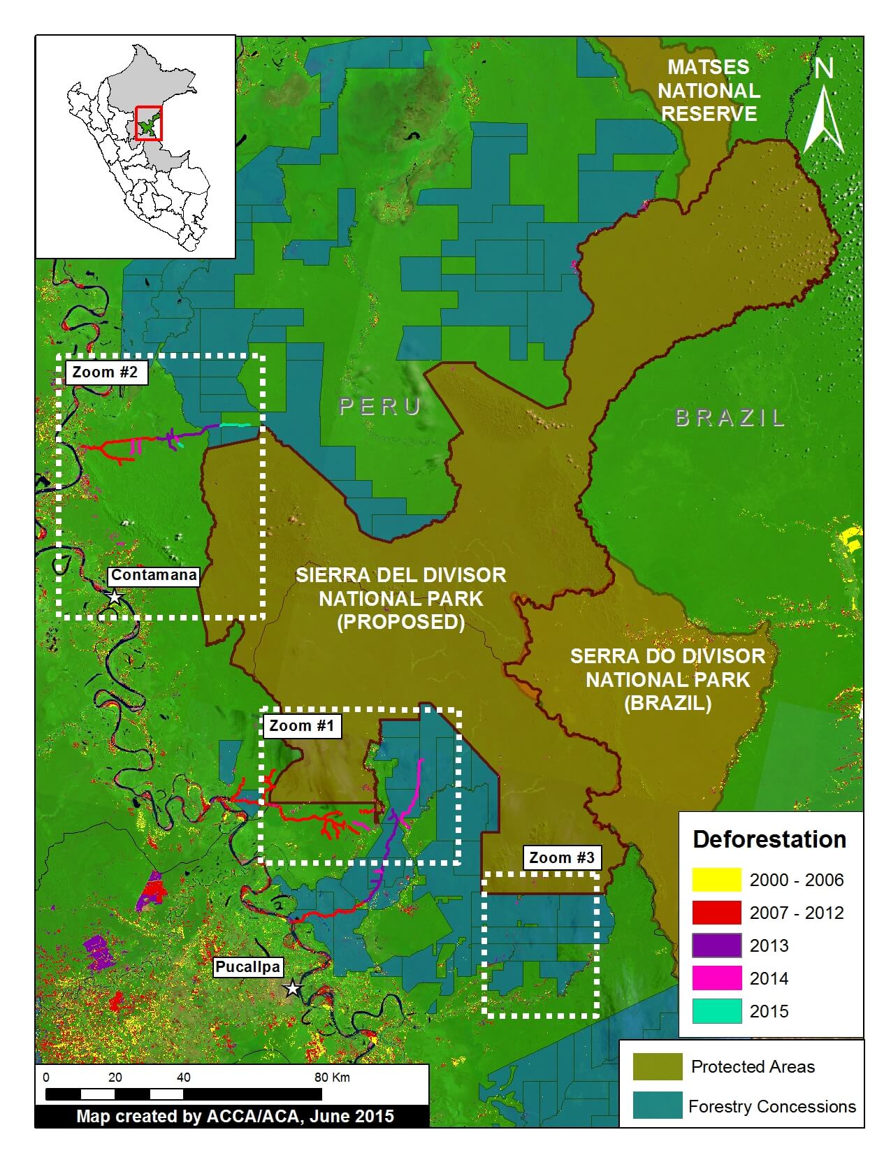
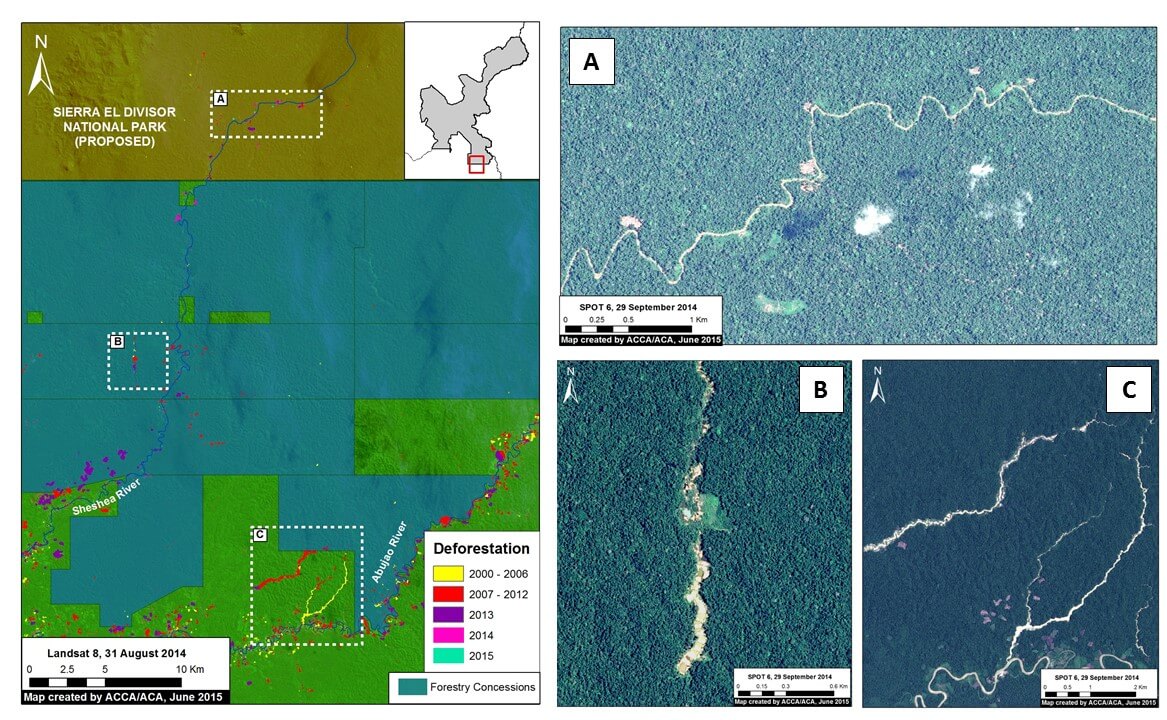
Recall that in Image of the Week #7 we documented the increasing threats (illegal coca, logging, and mining) to the Sierra del Divisor Reserved Zone. We just obtained brand new, high-resolution imagery showing new deforestation deep within this protected area during the month of June. Here, Image of the Week #8, presents new maps of this recent deforestation. According to several consulted experts, the cause of this deforestation is illegal coca cultivation or a new illegal logging camp.

Image 8a: Very high resolution (38 cm) image from June 23 showing new deforestation within the Sierra del Divisor Reserved Zone. Data: WorldView-3 from Digital Globe (NextView).

New Deforestation Detected

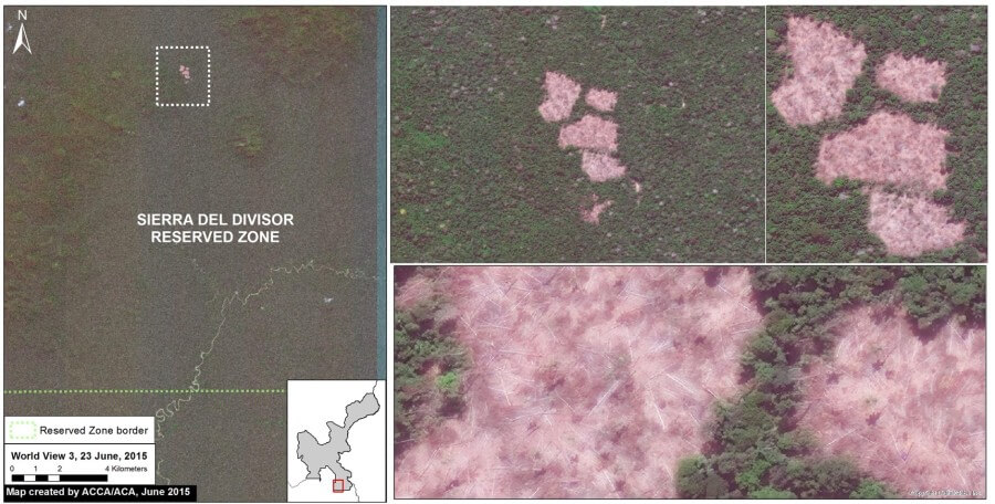
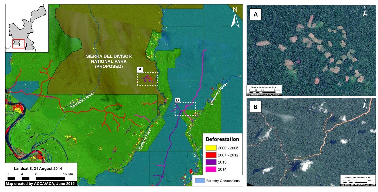
Image 8a shows the new deforestation detected within the southeast section of the Sierra del Divisor Reserved Zone. As of June 23, 2015 (the date of the image), the total new deforestation was 13 hectares. This deforestion is located between the La Cúpula and Shesha hills.

In Image of the Week #7 we showed that there is a series of illegal logging camps nearby, but this new deforestation is located much deeper in the reserve. According to several consulted experts, the cause of the new deforestation is illegal coca cultivation or a new illegal logging camp.

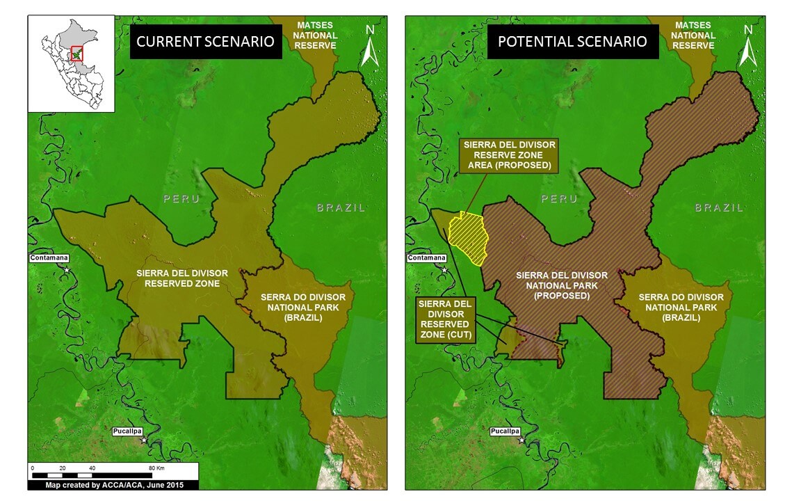
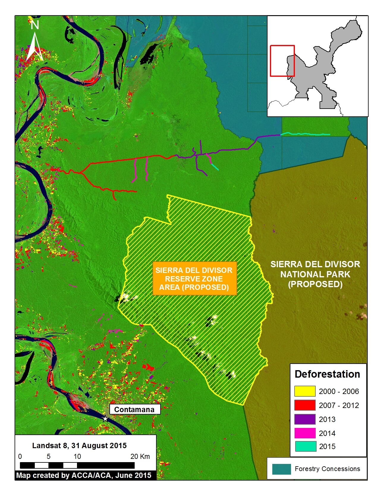
Updated Baseline Map


Image 8b. Updated baseline map of the southeast section of the Sierra del Divisor Reserved Zone. Data: MINAM, SERNANP, USGS, IBC, Hansen/UMD/Google/USGS/NASA.

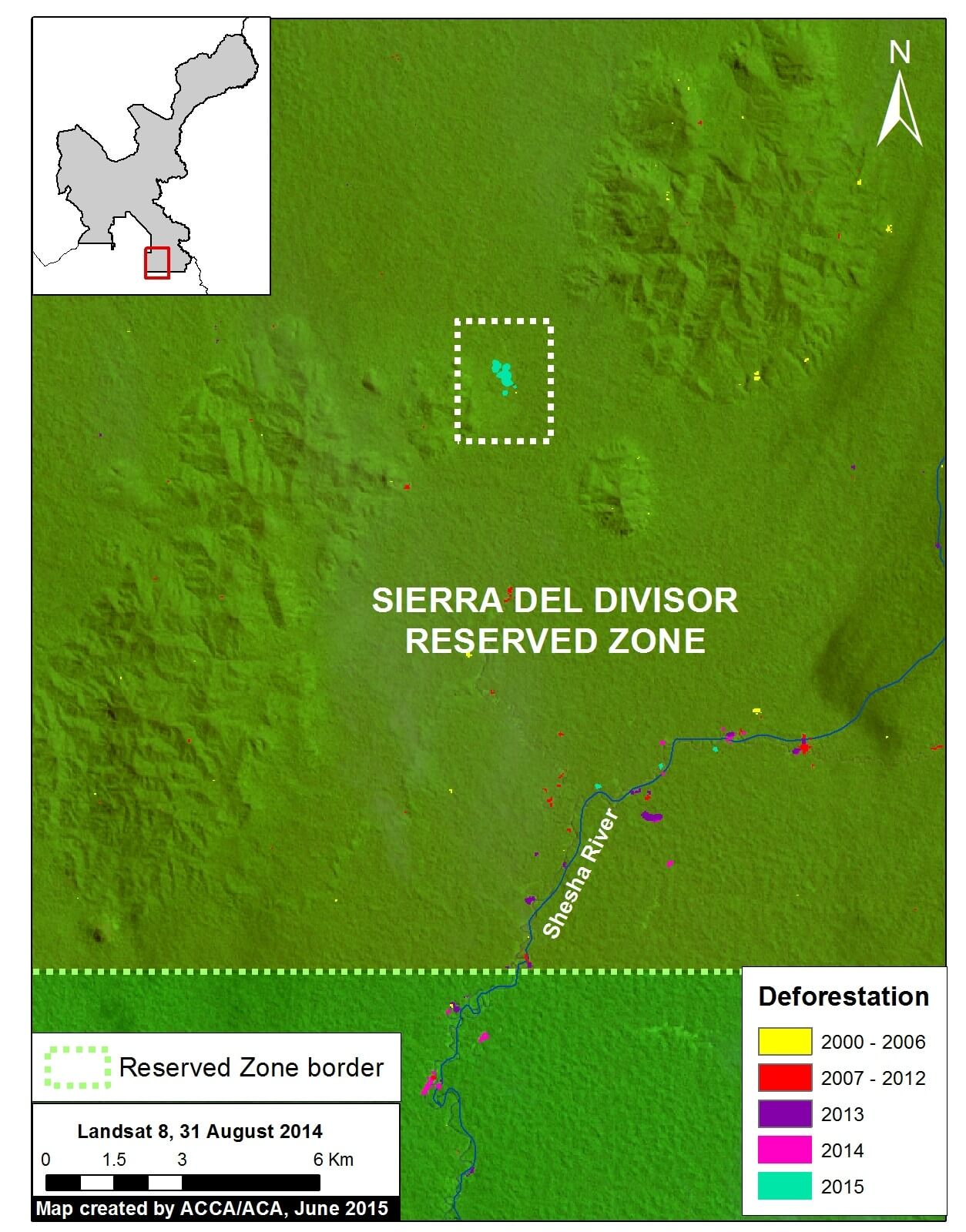
Image 8b is an updated map of the deforestation within the southeast section of the Sierra del Divisor Reserved Zone. Note that the new 2015 deforestation is found much deeper within the reserve than previous detected forest loss.

Confirming Recent Deforestation


Image 8c. Landsat time-series (2014-2015) of the recent deforestation. Data: USGS.

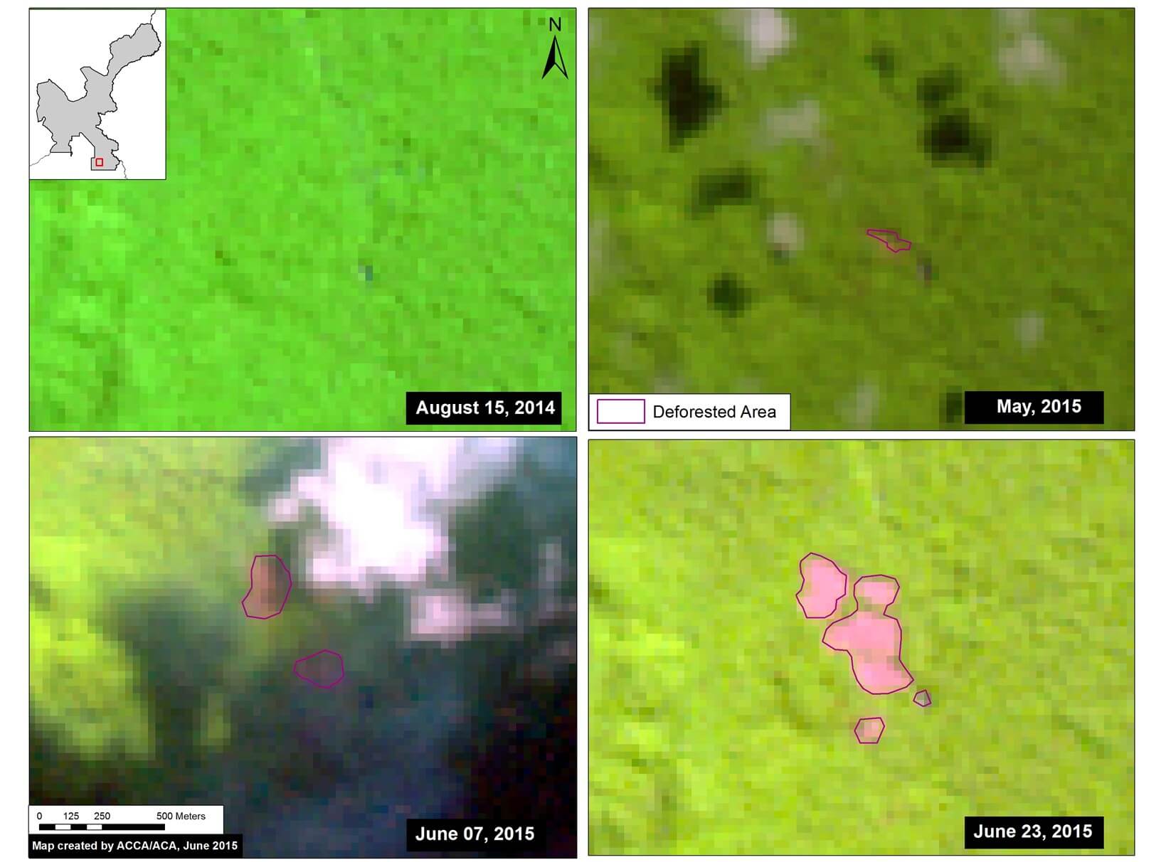
To better understand how the recent deforestation unfolded, we created a satellite (Landsat) image time-series. Note that in Image 8c all four panels show the exact same area over time. In August 2014, our focal area was completely forested. The first evidence of deforestation is seen in May 2015. In June 2015, the deforestation grows quickly.

Deforestation Within the Isconahua Territorial Reserve

Image 8d. Deforestation within the Territorial Reserve Isconahua. Data: MINAM, SERNANP, USGS, IBC, Hansen/UMD/Google/USGS/NASA.

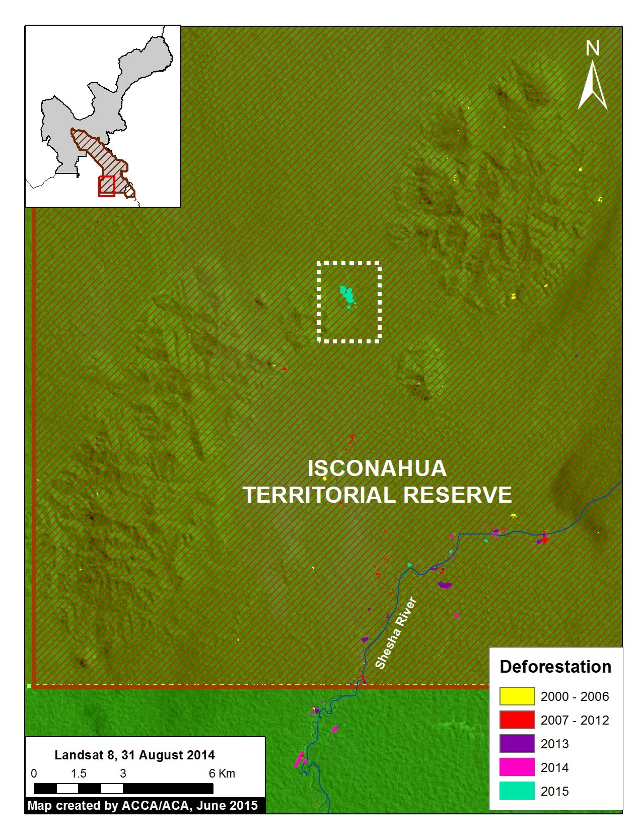
Image 8d shows the new deforestation is also located with the Isconahua Territorial Reserve.

This is an official land designation in favor of indigenous peoples in isolation, to protect their rights, habitat, and the conditions that ensure their existence and integrity as a people.

SERNANP Response

In response to this article, SERNANP (the Peruvian protected areas agency) issued this statement:

“The Sierra del Divisor Reserved Zone is a transitional area under the Peruvian National Service of Natural Protected Areas (SERNANP).

Over the past few years, Sierra del Divisor has made significant efforts in its fight against ilegal logging and other activities that threaten it. However, it is worth noting that Image of the Week #8: New Deforestation Detected Within Sierra del Divisor (Peru) in June corresponds with an area of overlap with the Isconahua Territorial Reserve, a sector in which the Ministry of Culture works in coordination with SERNANP.

As part of our actions, SERNANP has planned a flyover in the zone to verify information regarding the new deforestation alert in the Sierra del Divisor, and will continue with special park guard patrolling that began last week, despite the local climate conditions.”

+++

“La Zona Reservada Sierra del Divisor es un espacio de carácter transitorio a cargo del Servicio Nacional de Áreas Naturales Protegidas por el Estado (SERNANP).

En los últimos años la ZRSD ha realizado grandes esfuerzos en su lucha contra la tala ilegal y otras actividades que la amenazan. Sin embargo, hay que precisar que la Imagen de la Semana #8: Nueva Deforestación al Interior de la ZRSD corresponde al ámbito de traslape (superposición) con la Reserva Territorial Isconahua, donde también interviene el Ministerio de Cultura, la cual el SERNANP trabaja de manera conjunta con dicho sector.

En el marco de nuestras acciones, el SERNANP viene programando un sobrevuelo en la zona para verificar la información sobre la nueva alerta de deforestación en la ZRSD, y continuar con el patrullaje especial del personal guardaparque que viene realizando desde la semana pasada, pese a las condiciones climáticas del lugar”.

Citation

Finer M, Novoa S, Peña N (2015) Nueva Deforestación al Interior de la Zona Reservada Sierra del Divisor. MAAP: Imagen #8. Link: https://maaproject.org/2015/06/imagen-8-sierradivisor

Mining News Watch #16

Mining News Watch #16 covers the time period March 17- June 10, 2015

Top Stories

  • The Peruvian government announced in May that new complementary regulations for the formalization process will be released in August.
  • To date, only 16 permits have been issued for formalized mining, affecting just 631 of the 58,835 miners that started the process in Puno.
  • According to a pair of technical reports by the Amazon Conservation Association (ACA) and Conservaciόn Amazόnica (ACCA), 2,500 hectares (6,200 acres) has been deforested in the Tambopata National Reserve buffer zone due to illegal mining in the past two years.
  • The Ministry of the Environment (MINAM) reported that 40.5 tons of mercury enter the rivers of Madre de Dios annually.
  • The Foreign Relations Committee of the Peruvian Congress approved the Minamata Convention, and sent it to the full Peruvian Congress for final approval.

Read Full Article >

Image #7: Sierra Del Divisor – Growing Threats Highlight Importance of Creating National Park

As the Peruvian Government decides whether the Sierra del Divisor Reserved Zone should become a National Park, here in Image of the Week #7 we offer this new analysis of the current deforestation patterns of the area. A Reserved Zone classification, which was applied to Sierra del Divisor in 2006, is a temporary measure to protect an area of biological importance until the government is able to determine a final designation. National Park status represents the strongest possible final designation and would lead to strengthened legal protections to confront the growing array of threats we document below (namely, illegal coca, logging, mining activities).

Image of the Week 7a. Deforestation patterns within and around the proposed Sierra del Divisor National Park. Key data sources: MINAM, SERNANP, USGS, IBC, MINAGRI, Hansen/UMD/Google/USGS/NASA.

Key Findings:

We have detected several deforestation fronts within and around the current Sierra del Divisor Reserved Zone. These findings demonstrate the need for the stronger legal protections that would come with National Park status.

Most notably, we detected within and around the current Reserved Zone (and proposed National Park):

Deforestation for illegal coca cultivation within the southwestern section (Zoom #1).

New logging roads near both the southern and northwestern sections (Zooms #1 and #2).

Deforestation associated with illegal logging camps within the southeastern section (Zoom #3). This illegal logging is within the Isconahua Territorial Reserve, an official land classification designed to protect the territory of indigenous peoples in isolation.

Gold mining near the southern section (Zoom #3).

Background: From Reserved Zone to National Park

Image 7b. The current (left panel) and potential (right panel) scenario for the Sierra del Divisor region

Image 7b illustrates the current (left panel) and potential (right panel) scenario for the Sierra del Divisor region.

The vast majority of the Reserved Zone would become a National Park under the current proposal pending before the Peruvian government. The proposed Sierra del Divisor National Park covers a vast area (1,354,485 hectares) in the far eastern Peruvian Amazon (departments of Loreto and Ucayali), adjacent to the Brazilian border.

Note that several sections on the western side of the Reserved Zone would not be included, however. Part of the excluded area, in the northwest, will remain as a Reserved Zone and may be part of a future proposal for a Regional Conservation Area known.

Coca and Logging Roads in Southwestern Section (Zoom #1)

Image 7c. Zoom #1: Enhanced view of the southwestern section of the proposed national park. Panels A and B are high resolution satellite images of the areas indicated on the main map on the left. Key data sources: MINAM, SERNANP, ACCA, Hansen/UMD/Google/USGS/NASA, USGS, SPOT 6.

Image 7c provides an enhanced view of the southwestern section of the proposed National Park. It highlights an expanding deforestation cluster — 130 hectares between 2013 and 2014 — on the upper Calleria River (see “A” on the map). Our analysis indicates that illegal coca cultivation is the cause of this deforestation. Panel A shows a high resolution satellite image of this deforestation.

Also note that a new road is being constructed near the southwestern park boundary (see “B” on the map). We presume it to be a logging road because it passes through a forestry concession. Most notably, there was significant new construction in both 2013 and 2014, indicating that the road is in active use. In addition, high resolution imagery (see panel B) shows road width of about 30 meters, indicating that it may be designed for larger vehicles and heavy machinery.

Logging Road Approaching Northwestern Section (Zoom #2)

Image 7d. Zoom #2: Enhanced view of the northwestern section of the proposed national park. Key data sources: USGS, SERNANP, GOREL.

Image 7d provides an enhanced view of the northwestern section of the proposed National Park, showing the construction of another new logging road. We presume that it is a logging road because it is passing through forestry concessions with no other obvious destination. Most notably, there was new construction in 2013, 2014, and 2015 indicating that is an active logging road.

Also note the expanding deforestation, especially in 2014, outside of the town of Contamana, indicating the importance of creating a Regional Conservation Area in this area adjacent to the proposed National Park.

Illegal Logging and Gold Mining in Southeastern Section (Zoom #3)

Image 7e. Zoom #3: Enhanced view of the southeastern section of the proposed national park. Panels A, B, and C are high resolution satellite images of the areas indicated on the main map on the left. Key data sources: MINAM, SERNANP, ACCA, Hansen/UMD/Google/USGS/NASA, USGS, and SPOT 6.

Image 7e provides an enhanced view of the southeastern section of the Proposed National park. It highlights that both illegal logging (see “A” on the map) and gold mining (see “B” and “C” on the map) are present.

It is important to emphasize that this southeast section is part of the Isconahua Territorial Reserve administered by the Ministry of Culture. This is an official land designation in favor of indigenous peoples in isolation, to protect their rights, habitat, and the conditions that ensure their existence and integrity as a people.

Regarding the illegal logging, our analysis indicates the deforestation within the proposed National Park along the upper Shesha River is caused by a series of logging camps. Panel A shows a high resolution satellite image of this deforestation. This illegal logging is within the Isconahua Territorial Reserve.

Regarding the gold mining, there are two principal zones causing deforestation, one along the Shesha River and the other along the Abujao River. Panels B and C show high resolution images of these two mining areas. The headwaters of both river systems are born in the proposed park.

SERNANP Response

In response to this article, SERNANP (the Peruvian protected areas agency) issued this statement:

La Zona Reservada Sierra del Divisor es un espacio de carácter transitorio a cargo del Servicio Nacional de Áreas Naturales Protegidas por el Estado (SERNANP). La zona aledaña a esta área acoge a 14 Comunidades Nativas, las cuales aprovechan los servicios ecosistémicos en beneficio de más de 500 familias.

En los últimos años la ZRSD ha logrado mejores resultados en su lucha contra la tala ilegal enfrentando esta amenaza sobre todo en espacios de ámbito de las reservas territoriales, y continúa alerta por la deforestación asociada al cultivo ilícito de coca que se reporta en esta parte del país.

En ese marco, se ha reportado desde el 2011 a los sectores correspondientes para su incorporación dentro del Plan Anual de Reducción del Espacio Cocalero de tal forma que se haga frente a esta amenaza de manera estratégica.


Data Description:

Background map is a mosaic of four Landsat 8 images (30 m resolution) from August and September 2014. Any variation of green indicates forest cover. Note there is some scattered cloud cover. Data is from USGS.

Protected areas are darker green. Data for the proposed Sierra del Divisor National Park comes from its technical document (expediente técnico).

Black indicates areas that were deforested as of 2000 according to data from the Peruvian Environment Ministry (MINAM 2009). Yellow (2000-2006), red (2007-2012), and purple (2013) indicate areas that were deforested from 2000 to 2013 according to data published by Hansen et al. 2013 (Science 342: 850–53; Data download).

Pink and teal indicate areas that were deforested between 2014 and early 2015 based on our analysis of Landsat imagery using CLASlite forest monitoring software.


Citation

Finer M, Novoa S (2015) Sierra del Divisor: Growing Threats Highlight Importance of Creating National Park. MAAP Image #7. Link: https://maaproject.org/2015/06/image-7-sierra-del-divisor/

Cusco’s Own Spectacled bear workshop

Last week our Peruvian partner Conservación Amazónica–ACCA helped host a spectacled bear workshop in Cusco. Held from June 4 to 9, the workshopwhich brought together students, researchers, and decision makers in Peruset out to strengthen spectacled bear conservation and share information. Spectacled bears (Tremarctus ornatus) live along the spine of the Andes and are the only bear native to South America. They feature prominently in the worldview and culture of Andean populations but unfortunately, the bear is considered a vulnerable species

For 18 participants, the course was not only a chance to learn about the species and monitoring fundamentals, but also a chance to travel to Wayqecha Cloud Forest Biological Station, get their boots dirty, and experience hands-on learning. They installed camera traps and learned bear identification methods firsthand.

Global Big Day 2015 at Los Amigos

A collared puffbird at Los Amigos on last month's Global Big Day. Photo by Jorge Valdez.
A collared puffbird at Los Amigos on last month’s Global Big Day. Photo by Jorge Valdez.

Wow, the results are in! Los Amigos Biological Station participated in this year’s Global Big Day on May 9th in a big way. Global Big Day a day on which birders worldwide attempt to record as many species of birds as possible within a 24-hour period.

The 4-person team at Los Amigos included University of Michigan Ph.D. candidate Sean Williams. “My backyard in the Peruvian Amazon held more than 500 species in an area the size of Central Park, and I could not extinguish the blazing thoughts of the species I would encounter that day,” he wrote in a blog about the experience. 

By the end of the day, birders had seen a total of 308 species at Los Amigos—the fifth highest recorded site total in the world! Peru was also the country that saw the most bird species, totalling 1177 in all, almost a hundred more than the next closest country. (By the way, the two southeastern regions where we work, Madre de Dios and Cusco, saw the most bird species within Peru!)

Image #6: Expanding Gold Mining Deforestation Enters Amarakaeri Communal Reserve (Madre De Dios, Peru)

Recall that in Image of the Week #1 and Image of the Week #5 we documented how gold mining deforestation continues to expand within the Department of Madre de Dios, Peru (in the areas known as La Pampa and Upper Malinowski, respectively). Here, Image of the Week #6 documents how expanding deforestation from the mining zone known as Huepetuhe/Delta-1 is now entering the Amarakaeri Communal Reserve, an important Peruvian protected area that is co-managed by indigenous communities and Peru’s National Protected Areas Service (known as SERNANP).
Our analysis shows that gold mining deforestation, expanding from Huepetuhe/Delta-1, entered the southeast corner of the reserve in 2013 and expanded in 2014 and 2015. We also show that gold mining deforestation is spreading within the reserve’s south-eastern buffer zone.

Image of the Week 6a. Deforestation detected within and around the Amarakaeri Communal Reserve and its buffer zone. Zoom Area #1 indicates focal area in Images 6b and 6c, while Zoom Area #2 indicates focal area in Image 6d. Key data sources: MINAM, SERNANP, ACCA, USGS, IBC, Hansen/UMD/Google/USGS/NASA.

Key Findings:

According to our CLASlite analysis, deforestation entered the southeast corner of the Amarakaeri Communal Reserve in 2013 and expanded in 2014 and 2015 (see Zoom #1 below). Additional analysis revealed that the driver of this deforestation was gold mining due to the pattern and appearance of the forest loss.

We also detected increasing gold mining deforestation within the reserve’s south-eastern buffer zone between 2014 and 2015 (see Zoom #2 below). See below for more details.

We also detected a small amount of deforestation in 2014 from Hunt Oil’s drilling of Pad A within the reserve (see “B” in Image 6a). Note that overall deforestation from this gas exploration project has been very low because the company did not build an access road.

Gold Mining Deforestation Enters the Reserve (Zoom Area #1)

Image 6b. Zoom Area #1 provides an enhanced view of the deforestation within the southeast section of Amarakaeri Communal Reserve and its surrounding buffer zone. Key data sources: MINAM, SERNANP, ACCA, Hansen/UMD/Google/USGS/NASA, USGS.

Image 6b is a zoom view of the deforestation within the southeast section of Amarakaeri Communal Reserve and its surrounding buffer zone (see Zoom Area #1 in Image 6a for context).

Here, one can more clearly see how the gold mining deforestation entered the southeast corner of the reserve in 2013 and expanded in 2014 and 2015.

Total gold mining deforestation within this section of the Reserve is currently 11 hectares. Although this is currently only 1% of the Reserve’s total area, it represents a growing trend that may worsen.

Note that all of the rest of the deforestation in the image is within the reserve’s surrounding buffer zone.


Satellite Image Time-series of Deforestation Entering the Reserve (Zoom Area #1)

Image 6c. Satellite (Landsat 8) image time-series (2013 – 2015) of deforestation within the southeast section of the Amarakaeri Communal Reserve. Note that all four panels show the same location over time. Key data sources: USGS, SERNANP.

To better understand the deforestation dynamics over time within the southeast corner of the Amarakaeri Communal Reserve, we created a satellite (Landsat 8) image time-series. As seen in Image 6c, gold mining deforestation within the reserve is first seen in July 2013, and then slowly expands on several fronts until February 2015, the last good Landsat image for the area. Note that all four panels show the same location. Also note that all area in each panel outside the reserve is within its official buffer zone.

Gold Mining Deforestation Encroaching Upon Another Part of the Reserve (Zoom Area #2)

Image 6d. Zoom view of the deforestation within the south-eastern buffer zone of the Amarakaeri Communal Reserve. Left panel shows deforestation results data and right panel shows high resolution SPOT 7 imagery for the area in white dashed lines. Key data sources: MINAM, SERNANP, ACCA, Hansen/UMD/Google/USGS/NASA, USGS, and SPOT 7 from Airbus.

Image 6d shows how gold mining deforestation is encroaching on another part of the south-eastern section of the reserve (see Zoom Area #2 in Image 6a for context). As seen in the left panel, the deforestation within the buffer zone began expanding most notably in 2014 and 2015.

To confirm the driver of the deforestation, we acquired high resolution satellite imagery (SPOT 7 with 1.5 m resolution). As seen in the right panel of Image 6d, the pattern of the recent deforestation is characteristic of gold mining, and not other possible drivers such as agriculture.


Data Description:

Background map is a mosaic of two Landsat 8 images (30 m resolution) from April 10, 2014 and August 30, 2013. Any variation of green indicates forest cover. Note there is some scattered cloud cover. Data is from USGS.

Protected areas data is from SERNANP. Dark green indicates an established Peruvian national protected area or conservation concession and yellow-green indicates an official protected area buffer zone.

Black indicates areas that were deforested as of 2000 according to data from the Peruvian Environment Ministry (MINAM 2009). Yellow, orange, and red indicate areas that were deforested from 2000 to 2012 (each color covers a four year period) (Hansen MC et al. 2013 Science 342: 850–53; Data download).

Purple, pink, and teal indicate areas that were deforested between January 2013 and February 2015 based on our analysis of Landsat imagery using CLASlite forest monitoring software.


Citation

Finer M, Novoa S (2015) Gold Mining Deforestation Enters Amarakaeri Communal Reserve (Madre de Dios, Peru). MAAP: Image #6. Link: https://maaproject.org/2015/08/image-of-the-week-6-gold-mining-deforestation-enters-amarakaeri-communal-reserve/