Tracking Gold Mining With New Radar-Based Satellite Monitoring Tool

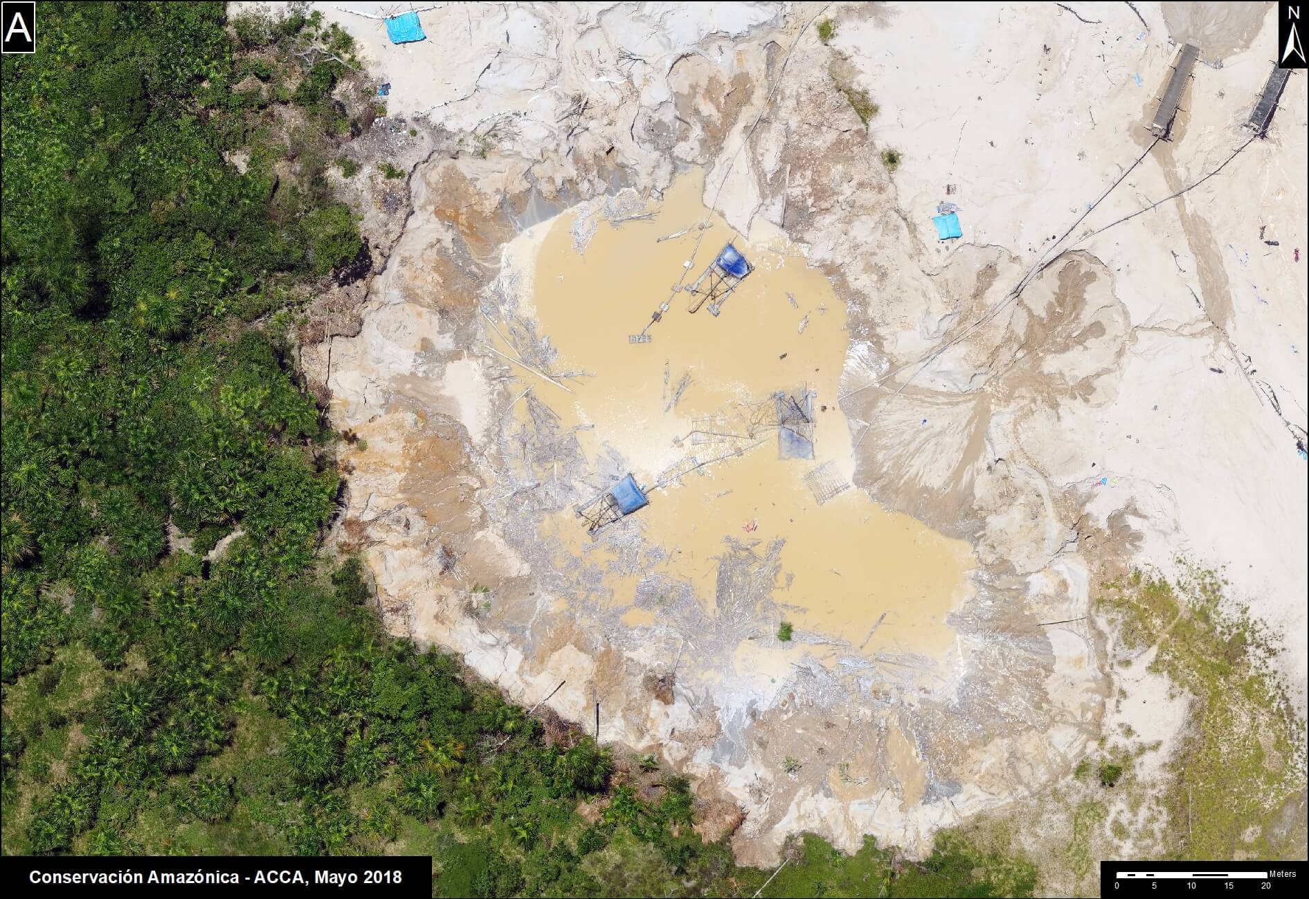
This past month we launched our Radar Mining Monitoring Tool (RAMI), which is a new satellite monitoring tool that incorporates radar technology. Traditional satellite monitoring is effective in tracking deforestation but is limited by cloud cover. This new tool will help us more effectively monitor and combat illegal gold mining in real-time, as radar allows us to see through clouds.

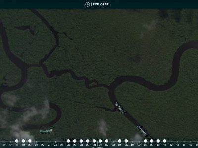
RAMI uses high-tech C-band synthetic aperture radar observations from the European Space Agency‘s Copernicus Sentinel-1 satellite, combined with freely-available high-resolution Planet data provided by the Norwegian International Climate and Forest Initiative (NICFI). This means that the radar sends and receives consecutive radio wave pulses to the Earth’s surface, which allows it to recognize subtle changes in forests. Because mining modifies the Earth’s surface differently than what occurs naturally, the radar can identify possible areas of illegal gold mining. When this data is combined with high-resolution satellite imagery, we can monitor areas deep within the Amazon forest remotely and in real-time.

“The novelty of using synthetic aperture radar in a real-time detection system in the Amazon is unique,” Sidney Novoa, Director for GIS at our sister organization Conservación Amazónica-ACCA, told NASA in a recently published article. “Because radar penetrates through clouds, it makes it possible to generate and obtain consistent and frequent information on gold mining areas year-round, without interference.” 

Sidney notes the unique approach of this collaborative project. “The bottom-up approach in which regional scientists from Conservación Amazónica-ACCA are working together with government agencies is unique,” he added. “Collaborating to develop a detection system fulfills targeted needs to halt the negative implications of illegal gold mining in the region.”

Watch the launch webinar for the RAMI Satellite Monitoring tool (in Spanish).


This project is a collaboration between: 

  • Peruvian government’s Ministry of Environment (MINAM)
  • National Program for Forest Conservation and Climate Change (PNCBMCC) 
  • National Aeronautics and Space Administration (NASA)
  • United States Agency for International Development (USAID)


The service is an effort by SERVIR-Amazonía, which is a joint initiative between NASA and USAID-Peru. In Peru, SERVIR-Amazonía is implemented by:

  • Our sister organization, Conservación Amazónica-ACCA
  • Alliance of Bioversity International and the International Center for Tropical Agriculture (CIAT)
  • Spatial Informatics Group (SIG)
  • Institute for Forest and Agriculture Management and Certification (IMAFLORA)
  • Fundación EcoCiencia.


Norwegian Agency for Development Cooperation Re-invests in Our Satellite Monitoring Model and Expands Access to Indigenous Peoples

The Madre de Dios region of Peru has long been home to a variety of cultural and ethnic groups for nearly three thousand years. The Indigenous Federation of Madre de Dios (FENAMAD in Spanish) is a regional organization that represents 37 indigenous communities belonging to seven linguistic groups. With the support of the Norwegian Agency for Development Cooperation (Norad), we will bolster FENAMAD’s territorial monitoring efforts within five key indigenous communities, and strengthen our efforts connecting real-time deforestation monitoring and reporting with policy action. With our partner EcoCiencia, we will expand our program to Ecuador and aid monitoring efforts of the Waorani indigenous community, who have experienced an influx of illegal loggers and gold miners following road construction in pursuit of oil within their territory. 

Through our partnership with these indigenous communities, we will provide real-time satellite monitoring of their territories while building their capacity to use this high-tech monitoring in the future. This project marks the first time we are able to share our satellite information with indigenous communities directly, in order to strengthen their existing surveillance systems, inform their on-the-ground patrolling, and help take action to stop illegal deforestation and degradation in their ancestral homelands. 

Not only will this project establish systematic monitoring focused on protected areas and indigenous territories, it will also deliver high-quality, actionable, real-time analysis to governments, centering our approach on providing both national and local support against deforestation. Nationally, we will help governments better utilize and act on real-time monitoring information, and locally, we will strengthen the abilities of key indigenous organizations in Peru – like FENAMAD – to detect and respond to threats in their territories by utilizing technology and engaging with the government.

Norad has been a long-standing partner of Amazon Conservation, supporting four of our forest monitoring projects over the past ten years. This new project will build upon the results we have accomplished with Norad so far in Peru and begin to extend our model to combat environmental crimes using technology and forest governance in Ecuador through local partnerships. 


Studying Greenhouse Gas Fluxes to Learn How Climate Change Affects the Amazon Rainforest

Photo of PUCP researchers on Amazon Conservation's Los Amigos Tower

These past few weeks significant scientific advances have been made at our Los Amigos Biological Station by the Pontificia Universidad Católica del Perú (PUCP).

The research group, led by professors Dr. Eric Cosio and Dr. Norma Salinas from the Department of Science and the Institute for Nature, Earth and Energy at INTE-PUCP, has installed an atmospheric flux system in our Los Amigos observation tower at a height of 196-foot (60 meter) above the ground to measure carbon, methane, and water vapor in the air. They are studying greenhouse gas fluxes to understand whether forests act as sinks or sources of these gases, and also show how they differ in different ecosystems (primary forest, secondary forest, wetlands and Andean highlands). They have multiple towers with these systems in various districts of Peru for comparison purposes.

Biometric data – that is, statistical analysis of ecological information – was taken from a forest area close to the tower to classify the forest next to the flux devices, and to estimate how much carbon is currently present in the standing forest. 


Photo of PUCP researchers at Amazon Conservation's Los Amigos Biological StationThis research and our collaboration with PUCP is a key example of how we put science and technology to work for conservation, helping to discover how climate change is affecting the Amazon Rainforest. The PUCP team will return to Los Amigos in August to recalibrate equipment, and then every three months afterwards to obtain data. They are looking to enhance the system with more gas flux devices over time, such as adding an atmospheric mercury meter. The gas flux data will be uploaded to a global platform for flux data, connecting our Los Amigos Biological Station to the rest of the world. Additionally, a weather station was placed on top of the Los Amigos tower, which provides very precise, digital, meteorological data. 

Special thanks to the Andes Amazon Fund and the Gordon and Betty Moore Foundation, for the support that made possible the purchase and installation of 8 solar panels that are powering the flux devices. 

Want to help make science possible?


Environmental License Secured For Pilot Açaí Processing Plant for Amazonian Community in Bolivia

After a long process, we’ve helped secure an environmental license authorizing the operation of a pilot açaí processing plant in the Villa Florida community of the Manuripi National Reserve in Bolivia – making the community one of the first in Bolivia. Securing this license is a significant achievement because it engages authorities to support efforts advancing these forest-friendly economic activities. 

Açaí is a strategic fruit within the framework of regional economic recovery, generating at least 100 immediate jobs for the local community as well as indirectly benefiting families through the revitalization of the local economy. Communities like Villa Florida collect açaí berries and Brazil nuts as a source of food and income. Both of these products can only grow in healthy, standing forests, thus supporting their sustainable harvest encourages conservation of these important ecosystems. Differently from Brazil nuts, açaí requires a transformation process to be done quickly in order to obtain the berries’ pulp, making a processing plant a vital necessity for communities who want to diversify their income and increase the value of their forest goods. 

Our on-the-ground sister organization in Bolivia, Conservación Amazónica-ACEAA, along with WWF-Bolivia, provided technical and financial support to the Villa Florida people  as well as the National Protected Areas Service of Bolivia (SERNAP) to obtain this license. 

“The future of açaí is promising; it is time to cement processes and strengthen policies that support its development and growth…improving living conditions, contributing to regional development, promoting local economies and inclusive conservation,” said Samuel Sangüeza Pardo, Country Representative for WWF-Bolivia.

The location of the pilot processing plant will be within the Manuripi-Heath Amazonian Wildlife National Reserve, a protected conservation area in Pando, Bolivia, that spans 1.8 million acres (​​747,000 ha). This biodiversity hotspot is home to 528 species of plants, 501 species of birds, 150 species of mammals, and 112 species of fish. Manuripi is already a major producer of Brazil nuts, exporting approximately 10,000 tons annually.

Photo via PANDO Vision (click to view the Facebook Live of the ceremony)

We were able to build on this existing sustainable infrastructure and help the community advance açaí as a second flagship product that they can export in order to build their economic power and diversify their income sources. 

Manuripi was established with two main objectives in mind: The first was to conserve the important forests of the Amazon in Northern Bolivia, while the second was to promote the sustainable use of wild resources through forest management that guarantees long-term productivity, improves the living conditions of the local population, and contributes to the development of the region. By helping establish this pilot processing plant, we once again reinforce the biodiversity and economic benefits of conserving forests that can provide renewable products, over other destructive activities such as logging or clearing land for cattle ranching.