MAAP #111: Fires in the Bolivian Amazon – Using Google Earth Engine to Monitor

Recent fire in the dry forests of the the Bolivian Amazon. Data: Planet.

We begin a new series on how to harness the power of the cloud to improve real-time monitoring in the Amazon and beyond.

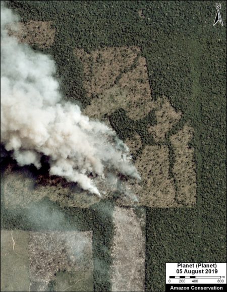
As the amount of data from satellite images has skyrocketed, so have the challenges of research teams to fully utilize this abundant and heavy (in terms of terabytes) information.

In response, tech companies such as Google, Amazon, and Microsoft have been offering their powerful computer power, via the internet (cloud), to help process, analyze, display, and store big data.

Here, we feature Google Earth Engine, which is designed for the free processing of geospatial information (including satellite imagery) and publishing results on web applications.

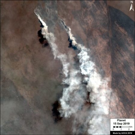
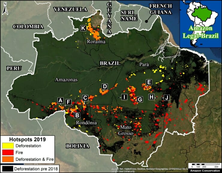
In our first example, we show the power of Google Earth Engine to help with fire monitoring in the Bolivian Amazon. As noted in our previous reports, the 2019 fire season in Bolivia has been intense, with numerous major fires in the Amazonian dry forests and savannas.

There is currently an urgent need for real-time monitoring of active fires to assist ongoing fire management efforts at the national level. In response, we developed the application described below.

MAAP #110: Major Finding – Many Brazilian Amazon Fires Follow 2019 Deforestation

In MAAP #109 we reported a major finding critical to understanding this year’s fires in the Brazilian Amazon: many of the 2019 fires followed 2019 deforestation events.

Here, we present our more comprehensive estimate: 125,000 hectares (310,000 acres) deforested in 2019 and then later burned in 2019 (July-September). This is equivalent to 172,000 soccer fields.*

Thus, the issue is both deforestation AND fire; the fires are often a lagging indicator of recent agricultural deforestation.

This key finding flips the widely reported assumption that the fires are burning intact rainforests for crops and cattle.

Instead, we find it’s the other way around, the forests were cut and then burned, presumably to enrich the soils. It is “slash and burn” agriculture, not “burn and slash.”

The policy implications are important: national and international focus needs to be on minimizing new deforestation, in addition to fire prevention and management.

This breakthrough data is based on our analysis of an extensive satellite imagery archive, allowing us to visually confirm areas that were deforested in 2019 and later burned in 2019 (see Methodology).

Below we present a new series of 7 striking timelapse videos that vividly show examples of 2019 deforestation followed by fires (See Base Map below for exact zoom locations).

MAAP #109: Fires and Deforestation in The Brazilian Amazon, 2019

Base Map. 2019 deforestation and fire hotspots in the Brazilian Amazon. Data: UMD/GLAD, NASA (MODIS), PRODES

The fires in the Brazilian Amazon have been the subject of intense global attention over the past month.

As part of our ongoing coverage, we go a step further and analyze the relationship between fire and deforestation in 2019.

First, we present the first known Base Map showing both 2019 deforestation and fire hotspots, and, importantly, the areas of overlap. The letters correspond to Zooms below.

Second, we present a series of 16 high-resolution timelapse videos (Zooms A-K), courtesy of the satellite company Planet. They show five scenarios that we have documented thus far in 2019:

  1. Deforestation (No Fire)
  2. Deforestation (Followed by Fire)
  3. Agriculture Fire
  4. Savanna Fire
  5. Forest Fire

The key finding is that Deforestation (Followed by Fire) is critically important to understanding this year’s fire season (see Zooms B-E).

We documented numerous cases of 2019 deforestation events followed by intense fires, covering at least 52,500 hectares (130,000 acres) and counting. That is equivalent to 72,000 soccer fields.

The other common scenario is Agriculture Fire in areas cleared prior to 2019, but close to surrounding forest (see Zooms F and G).

We are also now seeing more examples of Savanna Fire in grassland areas among the rainforest. These fires can be large — we show a 24,000 hectare burn (60,000 acres) in Kayapó indigenous territory (see Zoom H).

We did not observe major Forest Fires in the moist Brazilian Amazon during August, but we did document such fires in early March in Roraima state. As the dry season continues into September and October, however, forest fires become a greater risk.