MAAP #35: Confirming Amazon Deforestation by United Cacao in 2013 [High Res View]

To date, we have published 4 MAAP articles* tracking deforestation by the company United Cacao in the northern Peruvian Amazon (outside the town of Tamshiyacu in the Loreto region). In these articles, based on analysis of satellite imagery, we have documented the deforestation of 2,380 hectares (5,880 acres) related to this project.

The company, however, continues to deny this deforestation**. In general, their main response seems to be that the land in question had been deforested for previous agricultural projects prior to their arrival in 2013.

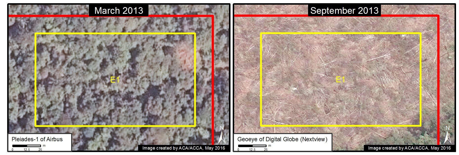
Here in MAAP #35, we show definitively that this assertion simply does not match the satellite evidence. This article is based on analysis of recently-acquired satellite images from early 2013, the time period that the cacao project began. These images show, in extremely high resolution, the large-scale deforestation of primary forest in the project area between March and September 2013.*** Click each image to enlarge.

It is important to resolve the deforestation-related issues because the company has plans to expand its agricultural land bank in the coming years. Please see this recent statement from the Peruvian Forestry Service (SERFOR) for details on the legal aspect of this case.

As a reference, at the end of the article there is a graphic (Image 35l) illustrating the difference (as seen in high-resolution imagery) between primary forest, secondary vegetation, agricultural areas, and deforested areas.


New Evidence of Large-Scale Deforestation in 2013

We recently obtained high-resolution satellite imagery from March 25, 2013, immediately before the beginning of the deforestation for the cacao project. Image 35a shows the same exact project area between March (left panel) and September (right panel) 2013. In March, the project area is predominantly covered with primary forest*** and contains only a few scattered patches of previously disturbed land. In contrast, in September, the project area is clearly undergoing a large-scale deforestation event (1,100 hectares at that time).
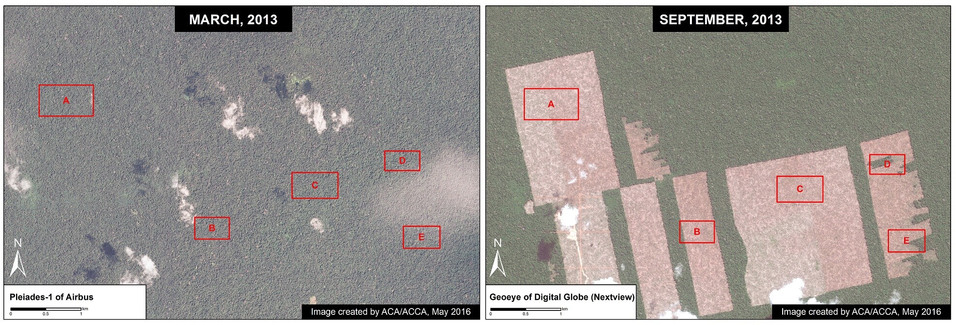
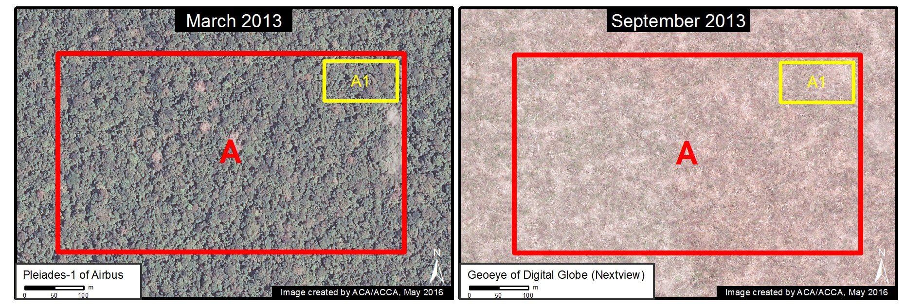
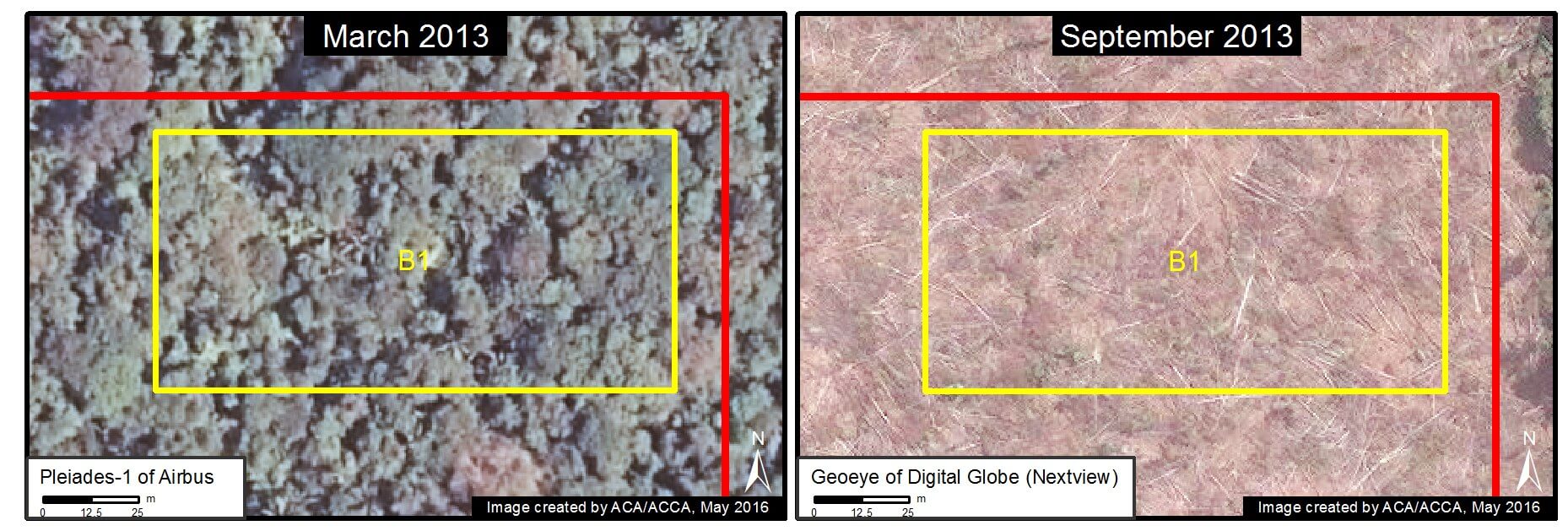
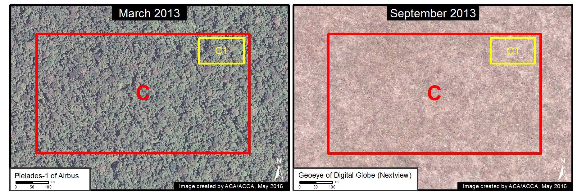
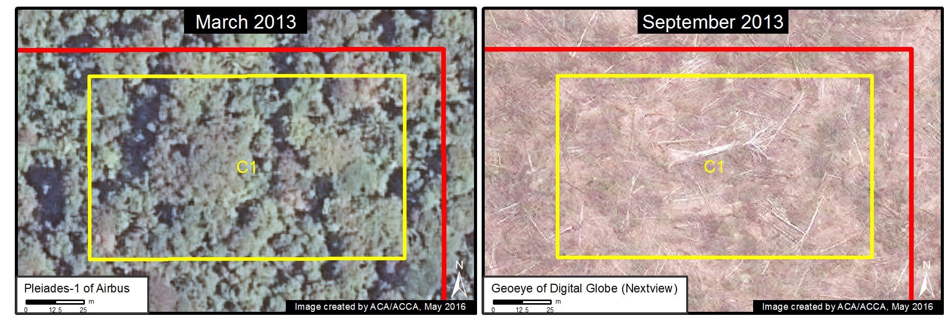
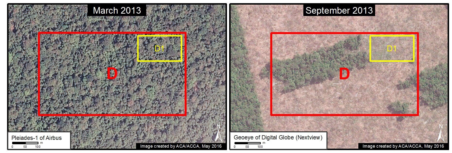
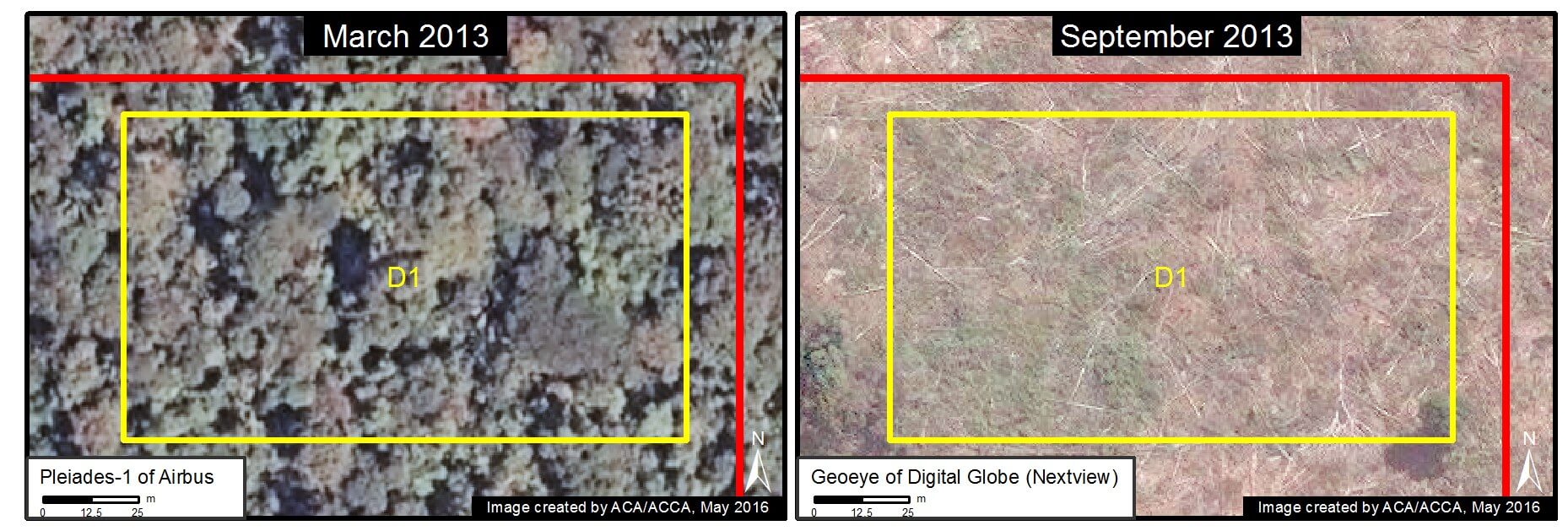
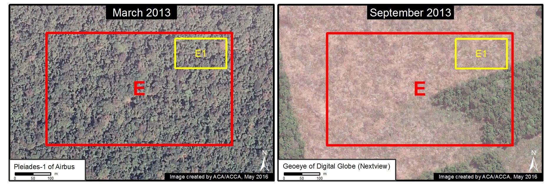
Image 35a. Data: Airbus, Digital Globe (Nextview)

Zoom A

In the following series of images, we show zooms of the areas indicated by Insets A-E in Image 35a. Each image shows the same exact area within the cacao project between March (left panel) and September (right panel) 2013. In all images, one can clearly see intact forest in March followed by large-scale deforestation in September.

Image 35b. Data: Airbus, Digital Globe (Nextview)
Image 35c. Data: Airbus, Digital Globe (Nextview)

Zoom B

Image 35d. Data: Airbus, Digital Globe (Nextview)
Image 35e. Data: Airbus, Digital Globe (Nextview)

Zoom C

Image 35f. Data: Airbus, Digital Globe (Nextview)
Image 35g. Data: Airbus, Digital Globe (Nextview)

Zoom D

Image 35h. Data: Airbus, Digital Globe (Nextview)
Image 35i. Data: Airbus, Digital Globe (Nextview)

Zoom E

Image 35j. Data: Airbus, Digital Globe (Nextview)
Image 35k. Data: Airbus, Digital Globe (Nextview)

Reference Graphic

Finally, for reference, Image 35l illustrates the difference (as seen in high-resolution imagery) between primary forest, secondary vegetation, agricultural areas, and deforested areas.


References

*MAAP #27, MAAP #13, MAAP #9, MAAP #2

**See articles in Directors Talk, La Region, y The Guardian

***see MAAP #9 for details on our time-series analysis dating back to 1985 that revealed that the vast majority of the project area is primary forest


Citation

Finer M, Cruz C, Novoa S (2016) Confirming Amazon Deforestation by United Cacao in 2013 [High Res View].  MAAP: 35.


MAAP #36: New Gold Mining Frontier in The Northern Peruvian Amazon

In several previous MAAP articles, we have detailed gold mining deforestation in the southern Peruvian Amazon. Here, we provide evidence of the first known case of gold mining deforestation in northern Peru.

A recent news article published by the Peruvian organization DAR reported that gold mining activity continues to increase in the Santiago River (see Image 36a), located in the Amazonas region of the northern Peruvian Amazon. The article also mentions that this gold mining activity is no longer restricted to the river, but is now entering the forest. There are mining concessions in the area, but according to a recent article published in The Guardian, the miners are not operating legally with permission from the concessionaire.

Here, we show the first satellite images that confirm that the mining activity is indeed causing deforestation along the Santiago River (see below). Click each image to enlarge.

Image 36a. Credit: DAR, April 2016

Satellite Images of Gold Mining Deforestation in Northern Peru

Image 36b shows a high-resolution image of the newly deforested area due to mining activity along the Santiago River (see yellow circle). The total forest loss to date is 8 hectares (20 acres).

Image 36b. Data: Planet Labs

Image 36c shows that the deforestation occurred between August 2014 (left panel) and August 2015 (right panel).

Image 36c. Data: USGS/NASA

Citation

Finer M, Novoa S (2016) Gold Mining Deforestation in the Northern Peruvian Amazon. MAAP: 36.


The Body Shop Foundation Supports Tarwi Project in Peru

The Body Shop Foundation Supports Tarwi Project in Peru Tarwi may not be a well-known legume in the US, but it is helping farmers in Peru not only sustain themselves financially, but also improve soil quality!

Thanks to extremely generous support from the The Body Shop Foundation, ACA has been working with local communities in the Andean highlands to plant and harvest tarwi on their land. Tarwi is an ancient Andean legume that has nitrogen-fixing properties, which can improve soil fertility and help reduce agricultural expansion, contributing toward the conservation of threatened highland forests. This means that farmers can plant it on degraded land and it will not only help restore the minerals in the soil, but will also be a good source of food to be consumed and sold. The crop has also been proven to deliver favorable returns for beneficiaries, as it has a strong local and regional market.

The tarwi project supports the livelihoods of 31 farmers across these communities by providing them with important information and constant technical support to promote best practices for a productive tarwi harvest. Through this project, ACA is helping to strengthen the tarwi farmers’ association Flor Azul (“Blue Flower” in English), referring to the crop’s delicate blue flowers. Together, we have already successfully improved market access and created a rotating seed fund, which ensures healthy harvests in the future and is central to maintaining the vibrant agricultural and biological diversity for which the region is known.


Local Partnerships in Bolivia Helping the Amazon Thrive  

In Bolivia, our sister organization ACEAA (Asociación Boliviana para la Investigación y Conservación de Ecosistemas Andino Amazónicos) is partnering with the local government of Pando to provide technical expertise for the preparation of a long-range plan to protect the Amazon and implement conservation projects on the ground.

“Working with the Pando government has been very rewarding,” says ACEAA’s Executive Director, Marcos Terán, “It is great to see their dedication to protect the local environment and all the great things we can accomplish together.” The local government has created public policies for land use and, together with ACEAA, has identified several areas of focus for environmental protection in the Pando region. ACEAA is supporting conservation projects in the area that are focused on addressing human-wildlife conflicts, managing natural resources and developing and protecting conservation areas.The two entities have also collaborated on creating a new conservation planning framework for the region. A great win for the Amazon! 

New Forest Protection Project in Peru! 

The Norwegian Agency for Development Cooperation (NORAD) has approved a grant of over $2 million dollars to ACA to help monitor and protect the forests in Peru! This exciting project will build capacity for near real-time deforestation monitoring efforts and forestry management in the country, helping us achieve REDD+ goals in the Peruvian Amazon.

The goal of the project is to help local governments and civil society operate active, effective and transparent near real-time deforestation monitoring systems, as well as train local stakeholders on using technical tools needed in this process. There will also be a component to help implement social and environmental policies and practices that reduce the pressure on forests. This project starts this year and will be funded until 2020, and will be done in partnership with our sister organization Conservación Amazónica (ACCA), the Peruvian Society for Environmental Law (SPDA) and Wake Forest University.

Make sure to keep an eye on our website where we’ll be announcing more information on this project soon! We thank NORAD for their continued collaboration to help us protect the Amazon! For more information on NORAD, visit: https://www.norad.no/en/front/ 

Birds Dominated the Month of May!  

May is a big birding month not only in North America, but across the world. ACA took part in some major birding activities throughout the month and we were excited to meet old and new birding friends!

The Biggest Week in American Birding took place in early May, to much success. The 10-day annual festival was organized and hosted by Black Swamp Bird Observatory and featured workshops, guided birding activities, half-day birding bus tours, keynote speakers, and more. Thousands of birders descended upon northwest Ohio to participate in the festival and observe the spring migration of songbirds. ACA marked our presence with a table and chatted with birders about our recently-renovated birding lodges in Peru.

We also participated in the Global Big Day, an international movement for participants to catalog as many bird species as possible in one calendar day. To raise awareness about bird diversity and conservation in Peru, our biological research stations participated in the Global Big Day, with impressive results! Our Los Amigos station recorded 246 bird species while our Villa Carmen station recorded 257 species – the second highest in the world!  All of our stations were in the top 20 in the world in terms of number of bird species recorded.

ACA’s sister organization in Peru, Conservación Amazónica (ACCA), along with other local partners, held in May the first bird-banding course in southeast Peru at our Wayqecha Cloud Forest Biological Station. Instructors included ACA staff, representatives of local organizations, and graduate students from the University of Florida. Thirteen Peruvian students participated in over 60 hours of instruction. The course was offered in coordination with the Tenth National Ornithological Conference, held in Chachapoyas, Peru.