Camera Traps: Colorfully Capturing Motmots

Our camera traps were set up to monitor a nest of the secretive giant armadillo (Priodontes maximus). However, during a recent recording session, a less reclusive forest friend stole the spotlight: a rufous motmot (Barypththengus martii). This curious bird belongs to the Momotidae family, which comprises a group of colorful arboreal species.

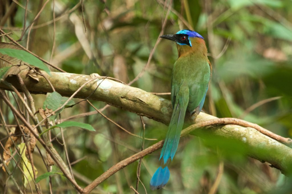
An Amazonian motmot (Momotus momota) showing off its racket-like tail. Photo: Will Sweet

Endemic to the tropics, among birds of the region, the motmots range in size from medium to medium-large. Despite their bright plumage—a combination of greens, blues and rufous (rust-like) colors—they are hard to spot. Most of the species have a long tail, and a few have two longer feathers that have racket-like tips. In contrast with many other bird families, motmots exhibit no sexual dimorphism: males and females look much alike, though on closer inspection males tend to be larger and have longer tails.

Spotting a motmot can be challenging because they sit still for long periods. They can be observed when they sally out to catch their prey, or through the sideways movement of their tails. It has been hypothesized that the turquoise-browed motmot (Eumomota superciliosa) uses this latter movement to signify to a predator that it has awareness of its presence. Thus advised, the predator might desist from an attack, preventing an unnecessary waste of energy on both sides.

Motmots can be found in a variety of forest types, from lowland tropical forest to template forests. Some species can even adapt to man-made habitats such as plantation and gardens. Motmots take their prey from leaves, twigs or branches of trees or other vegetation, and can be seen on the ground too. Smaller species feed on insects while larger ones additionally feed on other invertebrates, small vertebrates and fruits. The larger species like the Amazonian motmot (Momotus momota) and the rufous motmot have been reported to feed on bats and on poison dart frogs, respectively, in the latter case with no apparent harm to themselves.

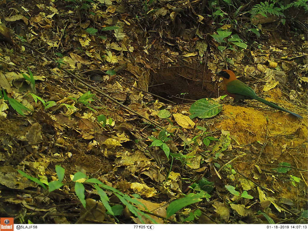
A rufous motmot (Barypththengus martii) inspects a burrow of the giant armadillo (Priodontes maximus).

 Most of the Momotidae have similar breeding behaviors. An exception is the tody motmot (Hylomanes momotula), which is also morphologically atypical and the most primitive species of the family. These ground-nesting birds use their feet to loosen the soil to later dig their nesting burrows. Both mates share this work and the chick rearing. Motmots are solitary nesters, but when limited suitable space is available, they may concentrate in groups. A new burrow is dug for each nesting season, often close to the previous burrow. As our camera trap and other studies have reported, the rufous motmots also use old burrows of armadillos and other mammals to nest.

Like many other Neotropical birds, the motmots are understudied, and there are much more to learn about them. Who knows which other surprises they may hold!

Further readings:
Skutch, A. F. (1971). Life History of the Broad-billed Motmot with Notes on the Rufous Motmot. The Wilson Bulletin Vol. 83, Nro 1.
Murphy, T. G. (2006). Predator-elicited visual signal: why the turquoise-browed motmot wag-displays its racketed tail. Behavioral Ecology.


MAAP #97: Deforestation Surge In The Colombian Amazon, 2018 Update

The Colombian Amazon is currently experiencing a deforestation surge (see graph).

The surge started three years ago (2016) and peaked in 2017 with the highest annual deforestation on record (214,744 hectares).*

Deforestation remains high in 2018: 156,722 hectares (based on early warning alert data).* If this estimate is confirmed, it would be the second highest on record (behind just 2017).

National experts indicate that land grabbing (acaparamiento de tierras) is an increasingly dominant direct driver of deforestation.

*Data from the University of Maryland. Annual data from Hansen et al (2013) [citation below] and 2018 data from GLAD alerts.

MAAP Colombia is a collaboration between Amazon Conservation and Amazon Conservation Team., funded by the MacArthur Foundation.

We also present a Base Map that shows the 2018 deforestation hotspots. Note that the deforestation is concentrated in three departments located in the transition area between the Amazon and Andes: Guaviare, Caqueta, and Meta.

We highlight the location of three critical areas that are examined in greater detail below: 1) Llanos de Yari, 2) Chiribiquete- La Macarena, and 3) Tinigua National Park.

For the Base Map and Zooms below, please click on the image to enlarge or download.

Base Map. Deforestation hotspots in the Colombian Amazon. Click to enlarge. Data- UMD:GLAD, Hansen:UMD:Google:USGS:NASA, PNN, SIAC, RAISG

Zoom 1: Llanos de Yari

Zoom 1 shows deforestation expanding towards western Chiribiquete National Park. In fact, in 2017-18 (purple and pink on map), deforestation has occurred well within the park. 

Zoom 1. Llanos de Yari. Click to enlarge. Data- DigitalGlobe, UMD:GLAD, Hansen:UMD:Google:USGS:NASA, PNN, SIAC, RAISG

Zoom 2: Chiribiquete – La Macarena

As we first reported in MAAP #86, the area between Chiribiquete and La Macarena National Parks is currently experiencing one of the most intense deforestation surges. Zoom 2 shows the most recent deforestation (indicated in red and pink) is entering the newly expanded section of Chiribiquete National Park. 

Zoom 2. Chiribiquete – La Macarena. Click to enlarge. Data- Planet, UMD:GLAD, Hansen:UMD:Google:USGS:NASA, PNN, SIAC, RAISG.

Zoom 3: Tinigua National Park

Zoom 3 shows how 2018 has seen a surge of deforestation deep within Tinigua National Park (see pink). 

Zoom 3. Tinigua National Park. Click to enlarge. Data- Planet, UMD:GLAD, Hansen:UMD:Google:USGS:NASA, PNN, SIAC, RAISG

References

Planet Team (2017). Planet Application Program Interface: In Space for Life on Earth. San Francisco, CA. https://api.planet.com

Hansen, M. C., P. V. Potapov, R. Moore, M. Hancher, S. A. Turubanova, A. Tyukavina, D. Thau, S. V. Stehman, S. J. Goetz, T. R. Loveland, A. Kommareddy, A. Egorov, L. Chini, C. O. Justice, and J. R. G. Townshend. 2013. “High-Resolution Global Maps of 21st-Century Forest Cover Change.” Science 342 (15 November): 850–53. Data available on-line from:http://earthenginepartners.appspot.com/science-2013-global-forest.


Citation

Hettler B, Thieme A, Finer M (2018) Deforestation Surge in the Colombian Amazon: 2018 update. MAAP: #96.