
Image 21a illustrates a recent illegal gold mining invasion of the Tambopata National Reserve. Tambopata is an important protected area in the southern Peruvian Amazon (department of Madre de Dios). Image 21a compares two high-resolution (0.5 m) images taken two months apart over the same area along the northern border of the reserve. One can clearly see the beginning of the illegal gold mining activity and deforestation within the reserve between September (left panel) and November (right panel) 2015. For more context regarding the area in question, see the yellow box in Image 21b.
Month: November 2015
MAAP #21: Illegal Gold Mining Deforestation Enters Tambopata National Reserve (Madre De Dios, Peru) [High-Resolution View]
*Note: During the review process for this article, a major operation against illegal mining activities was carried out by the Peruvian government in the area described below.
Image 21a illustrates a recent illegal gold mining invasion of the Tambopata National Reserve. Tambopata is an important protected area in the southern Peruvian Amazon (department of Madre de Dios). Image 21a compares two high-resolution (0.5 m) images taken two months apart over the same area along the northern border of the reserve. One can clearly see the beginning of the illegal gold mining activity and deforestation within the reserve between September (left panel) and November (right panel) 2015. For more context regarding the area in question, see the yellow box in Image 21b.
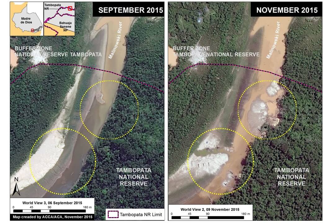
Image 21a. Recent invasion of Tambopata National Reserve. Data: SERNANP, WorldView-2 and WorldView-3 of Digital Globe (NextView).
Reference Map
Image 21b is a reference map showing the above detailed area in the larger context between the northern border of the Tambopata National Reserve and the illegal gold mining zone known as La Pampa. The yellow box corresponds to the area detailed in Image 21a. Note that the original boundary of the reserve created in 2000 no longer coincides with the route of the Malinowski River due to its natural movement over time.
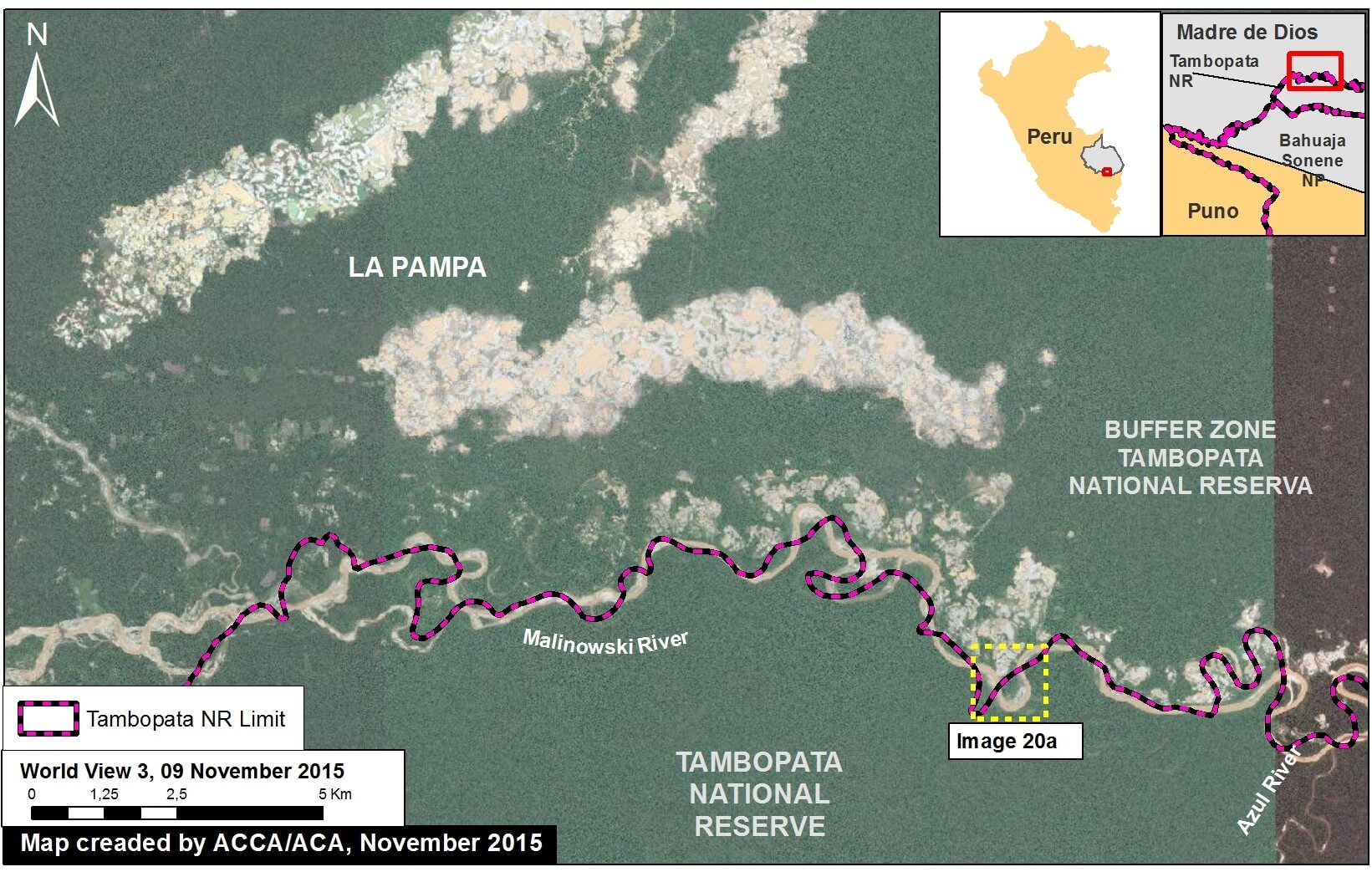
Image 21b. Reference Map. Data: SERNANP, WorldView-2 of Digital Globe (NextView).
Deforestation Data
Image 21c presents an updated analysis of the deforestation in the area between La Pampa and the Tambopata National Reserve. In this specific area, we documented the deforestation of 2,518 hectares (6,222 acres) between 2013 and 2015, the vast majority of which is clearly linked to illegal gold mining activities. The majority of this recent deforestation has occurred in La Pampa, a bit north of the reserve (but within its buffer zone). However, recent deforestation has also occurred along the Malinowski river, which forms the northern boundary of the reserve in this area.
In Image 21c, the data from 2000-2014 came from Hansen/UMD/Google/USGS/NASA, while the data from 2015 came from our own analysis using CLASlite.
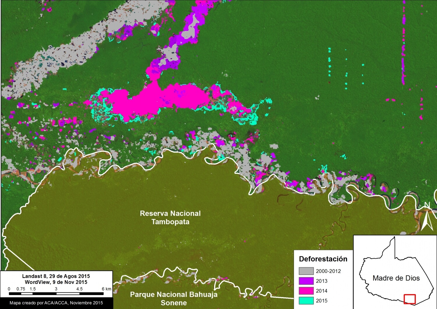
Image 21c. Analysis of deforestation. Data: CLASlite, Hansen/UMD/Google/USGS/NASA, SERNANP, USGS, WorldView-2 of Digital Globe (NextView).
Citation
Finer M, Novoa S, Snelgrove C, Peña N (2015) Confirming an Illegal Gold Mining Invasion of the Tambopata National Reserve (Madre de Dios, Peru) [High-Resolution View]. MAAP #21.
MAAP #19: Gold Mining Deforestation Advancing Along Upper Malinowski River (Madre De Dios, Peru)
In MAAP #5, we described the intensifying deforestation along the Upper Malinowski River in the department of Madre de Dios, Peru. Here in MAAP #19, we update this information and confirm that the deforestation continues at a rapid pace. This finding is based on analysis of three high-resolution images between September 2014 and November 2015. As described below, we document the deforestation of 392 hectares (969 acres) between September 2014 and November 2015 due to gold mining along the Upper Malinowki River.
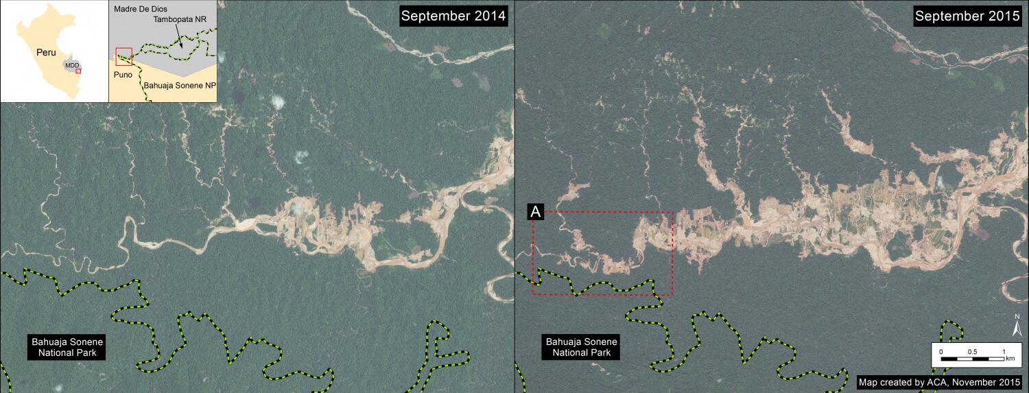
Image 19a. Gold mining deforestation between September 2014 and 2015 along Upper Malinowski. Data: SERNANP, WorldView-2 from Digital Globe (NextView).
Image 19a shows a comparison of two high resolution (0.5 m) images taken one year apart over the same area along the Upper Malinowski River (left panel is from September 2014, while the right panel is from September 2015). Comparison analysis of these images reveals two primary findings. First, deforestation is rapidly spreading upstream along the Upper Malinowski and its tributaries.
Second, this deforestation is nearing the border of the Bahuaja Sonene National Park boundary (see Image 19b).
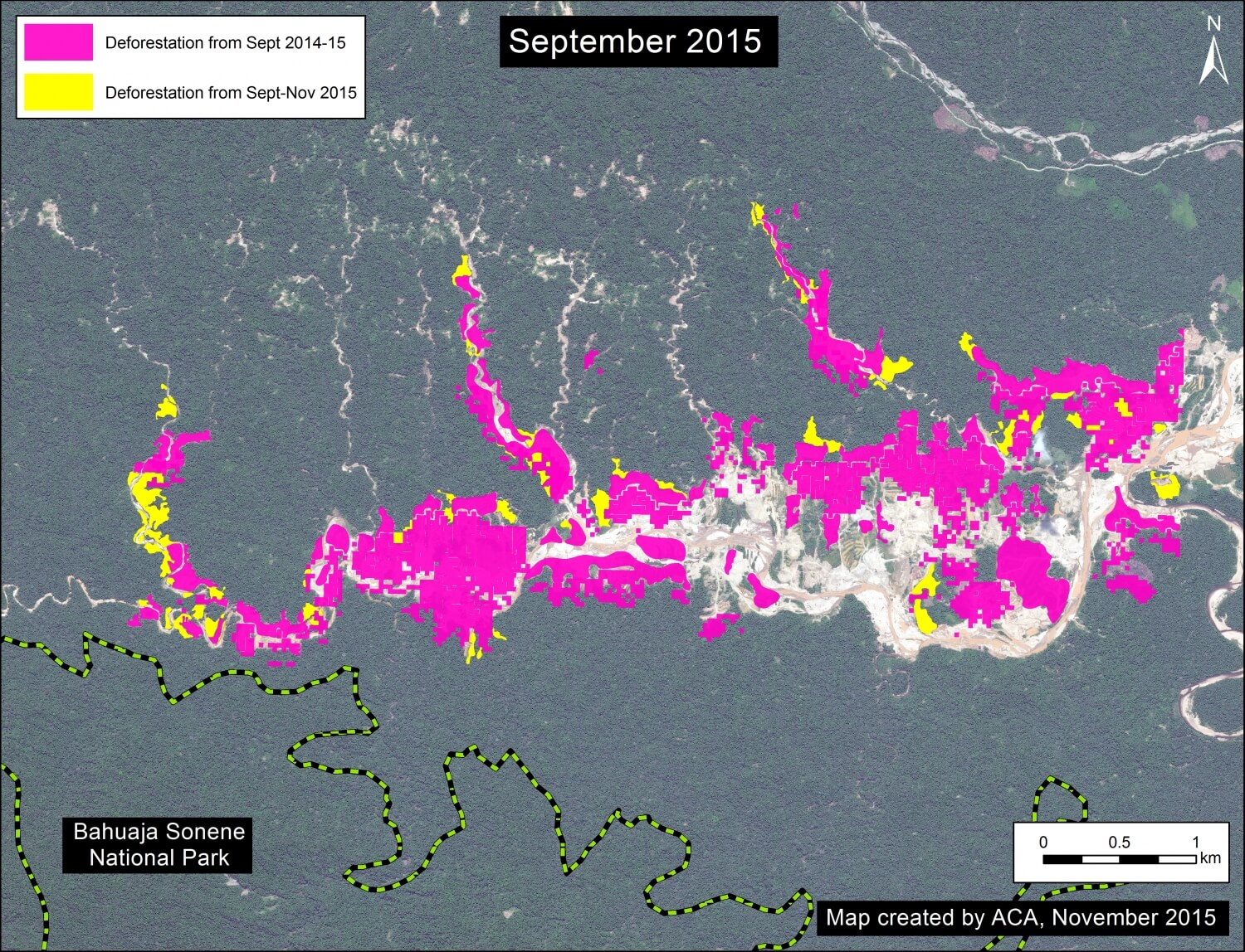
Image 19c. Deforestation analysis between September and November 2015 along the Upper Malinowski. Data: CLASlite, SERNANP, WorldView-2 from Digital Globe (NextView).
Deforestation Analysis
Image 19c is a detailed deforestation analysis between the two images. We documented the deforestation of 352 hectares (870 acres) due to gold mining activities between September 2014 and September 2015 along the Upper Malinowski (note: this calculation covers the area displayed in Image 19a).
Image 19b. Zoom of gold mining deforestation near the Bahuaja Sonene National Park. Data: SERNANP, WorldView-2 from Digital Globe (NextView).
During preparation of this article, a new high resolution image over the same area from November 2015 became available. As an indication of how rapidly the gold mining is advancing, we documented an additional deforestation of 40 hectares (99 acres) between September and November 2015.
Thus, we documented a total deforestation of 392 hectares (969 acres) between September 2014 and November 2015 along the Upper Malinowki.
Two Gold Mining Deforestation Fronts
The Upper Malinowki is just west (and upstream) of the mining zone known as La Pampa featured in MAAP articles #1, #12, and #17. These currently appear to be the two major gold mining deforestation fronts in Madre de Dios. Image 19b illustrates the general location of these two areas (“C” indicates La Pampa and “D” indicates the Upper Malinowski). Note that La Pampa is within the buffer zone of the Tambopata National Reserve and the Upper Malinowski is within the buffer zone of the Bahuaja Sonene National Park.
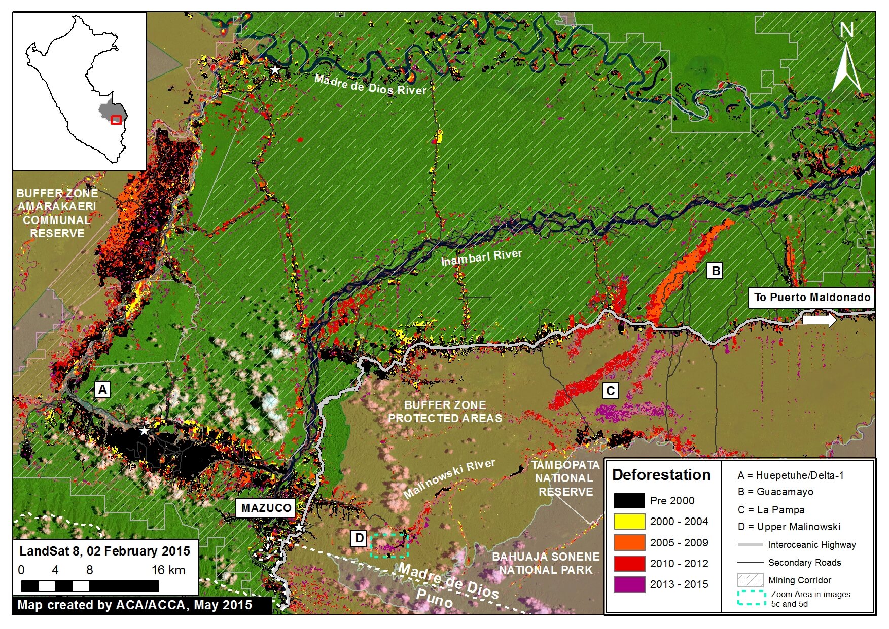
Imagen 19d. General location of the Alto Malinowski (“D”) and La Pampa (“C”). Data: CLASlite, MINAM, SERNANP, ACCA, Hansen/UMD/Google/USGS/NASA, USGS.
Citation
Finer M, Snelgrove C (2015) Gold Mining Deforestation Rapidly Advancing along Upper Malinowski River (Madre de Dios, Peru). MAAP: 19.
Mining News Watch #18
Mining News Watch #18 covers the time period July 31st- October 31, 2015
Top Stories
- There have been three police raids in Madre de Dios this summer in an attempt to stop illegal gold mining in the region.
- The Amazon Conservation Association released high-resolution images showing the intensity of illegal gold mining in La Pampa, Madre de Dios.
 Loading...


