MAAP #72: New Gold Mining Deforestation Zone in Peruvian Amazon: The Upper Malinowski (Madre De Dios)

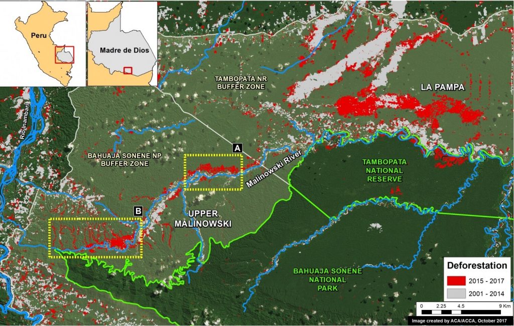
In a series of previous reports (MAAP # 60), we have described the dire gold mining deforestation in the southern Peruvian Amazon, most notably in the area known as “La Pampa” (see Base Map). However, over the past 3 years another critical area has emerged in the region: the Upper Malinowski. This area is located near the headwaters of the Malinowski River, upstream of La Pampa (see Base Map).

Here, we show satellite images of the rapid advance of gold mining deforestation in two sectors of the upper Malinowski. In total, we document the deforestation of 3,880 acres (1,570 hectares) between 2015 and 2017 inside the buffer zone of the Bahuaja Sonene National Park.

Mapa Base. Datos: SERNANP, UMD/GLAD, MINAM/PNCB, Hansen/UMD/Google/USGS/NASA

A sneak peek at our Los Amigos Birding Lodge

In the 2015 Global Big Day, Los Amigos Birding Lodge registered the fifth highest number of bird species in the world (308) – and with good reason.  Not only do we have sharp-eyed bird guides stationed there, but Los Amigos is adjacent to the Los Amigos Conservation Concession and just east of world-famous Manu National Park, which means it is surrounded by millions of acres of protected wilderness.

The landscape is a mosaic of terrestrial and aquatic habitats, including palm swamps, bamboo thickets, oxbow lakes, and various types of flooded and non-flooded forests. Wildlife at Los Amigos is incredibly abundant, with nearly 600 bird species, such as Harpy Eagle, Spix’s and Blue-throated Piping-Guan, Razor-billed Curassow, Western Striolated Puffbird, Rufous-capped Nunlet, Pavonine Quetzal, Rufous-fronted Antthrush, and Pale-winged Trumpeter, as well as fascinating Amazonian mammals such as giant otters, spider monkeys and jaguars. A whopping 11 species of primate can be found in this area, such as the Tufted Capuchin (pictured below).

Los Amigos can be accessed via road and river from Puerto Maldonado, or via a lazy two-day boat ride from Villa Carmen. To experience the full Andes-to-Amazon adventure, many travelers hit all three of our lodges in a down-slope direction along Manu Road. After flying from Lima to Cusco, for example, a rewarding vacation starts at Wayqecha Cloud Forest Lodge (situated at 9,880 ft), heads down-slope to Villa Carmen Lodge (at 3,940 ft), and then winds its way down the Madre de Dios River to Los Amigos, with stops along the way to see a bustling clay lick (or collpa) featuring Scarlet, Red-and-green and Chestnut macaws. Sometimes, large mammals such as tapirs, capybaras, giant otters, and even jaguars can be spotted from the boat. Finally, after enjoying a filling, all-natural dinner at the lodge, Tawny-belied Screech-Owl, Spectacled, Crested and Mottled Owls can be listened for in the night.

Los Amigos features seven cabins with basic accommodations that start at $95 per person (double occupancy). Our staff can arrange a quality bird guide as well as all ground and boat transportation for your trip.

Your next wildlife adventure could be the best you ever had!  Book a stay at Los Amigos Birding Lodge.

More information here >>

Life under bamboo thickets

Have you ever walked through a bamboo patch? If not, let me warn you about possible scratches, torn shirts or pants, and several up and downs you are certain to encounter. It doesn’t seem very promising -perhaps not for us- but for other species this habitat can be paradise. If you ever found yourself in a bamboo patch, stop and listen all the different birds’ calls or songs. In Los Amigos (LA), a “pip’ip’ip-pip’ip” call of tiny flammulated pygmy-tyrants, a “TEW tew-tew-tew’tew’tew’tu’tutu” song of white-lined antbirds (pictured on the right), or a “tr-tr-tr-tr-tr-TR-TR-TR-TR-TR” of the rare Peruvian recurvebill are just a few of the many birds inhabiting this particular thorny habitat.

There are several bamboo patches (“pacales”) of the genus Guadua spp., mostly within terra firme habitats in LA. Guadua bamboo patches occupy tree gaps, usually of 30-200 m in diameter -sometimes larger. They are highly dominant due to their massive seed production and their long vegetative growth phase, which allows them to colonize canopy gaps and often generate monodominant stands, causing mechanical damage to trees and saplings and altering the growth of understory trees. Compared to other types of monodominant habitats (i.e. Mauritia flexuosa palms), bamboo patches survive around 30 years after a short flowering event, followed by death over several square kilometers. Bamboo having a relatively short-term period of life could be detrimental for particular bird species that have found in bamboo habitats all what they need to flourish. Among monodominant habitats, bamboo patches harbor a higher diversity of specialized insectivorous birds.

But, what makes bamboo thickets so special? The wide array of food resources, from forest floor arthropods to a variety of insects colonizing bamboo internodes, culms, hollow stems etc.; and different vegetation structures (i.e. stems, leaf, and light intensity) are key habitat attributes that make bamboo patches a productive hotspot with highly specialized insectivorous birds. During the long bamboo vegetative phase these birds have plenty food resources, but questions arise when trying to understand what happens to these birds when the bamboo dies. Insectivorous bamboo specialists may experience population decline; move to different habitats or to another suitable bamboo patch. Considering current increased rates of habitat loss and fragmentation, the decrease of insectivorous bird richness in bamboo die-off should be particularly studied. The lack of suitable bamboo patches along with the spatial and temporal fluctuation of bamboo patches could increase the risk of extinction of this group of birds who have found in the bamboo its home.

For more references:

Areta, J. I. and Cockle, K. L. 2012. A theoretical framework for understanding the ecology and conservation of bamboo-specialist birds. Journal of Ornithology, 152 (Suppl 1): S163-S170.

Cockle, K. L. and Areta, J. I. 2013. Specialization on bamboo by Neotropical birds. The Condor 115(2): 217-220.

Lebbin, D. J. 2007. Habitat specialization among Amazonian birds: why are there so many Guadua bamboo specialists? Ph.D. dissertation, Cornell University, Ithaca, NY.

Lebbin, D. J. 2013. Nestedness and patch size of bamboo-specialist bird communities in southeastern Peru. Condor 115: 230–236.

MAAP #71: Gold Mining Threatens Amarakaeri Communal Reserve, Again

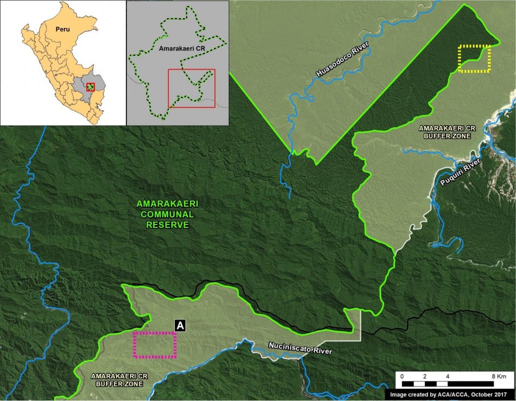
In an earlier series of articles (MAAP #6, MAAP #44, MAAP #64), we showed the illegal gold mining invasion of a section of Amarakaeri Communal Reserve (see yellow box in Base Map), as well as the rapid response by authorities to remove the miners. It was an important case given that Amarakaeri is an important Peruvian protected area, co-

managed byPeru’s protected areas agency (SERNANP) and indigenous communities (represented by the ECA Amarakaeri).

However, here we highlight the rapid advance of gold mining deforestation towards another section of Amarakaeri Communal Reserve, in the region of Cusco to the south (see purple box in Base Map).

*According to a statement from SERNANP, they are jointly coordinating with the ECA Amarakaeri and competent authorities such as the National Police, Prosecutor’s Office, and National Forest Service (SERFOR), regarding actions to stop the advance of illegal gold mining, and generating and comprehensive solutions to the problem.

Image 71. Base Map
Image 71. Base Map

MAAP #70: “Hurricane Winds” In the Peruvian Amazon, A 13 Year Analysis

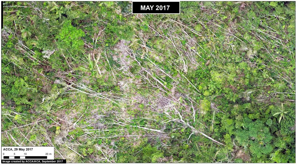
In an earlier report, MAAP #54, we described the natural phenomenon of “hurricane winds” in the Peruvian Amazon. These strong wind storms (not true hurricanes) cause a chain reaction of fallen trees and may blow down hundreds of acres of Amazonian forest (see Drone Image below).

This report presents an analysis of the frequency and intensity of hurricane winds in the Peruvian Amazon over the past 13 years (2005-17). The analysis is based on the annual forest loss data and early warning alerts data.

Drone Image. Source: ACCA