
 In the first two installments of a new series monitoring soy deforestation in Bolivia, we provide more accurate estimates of total soy production-based deforestation and some of the major actors driving this significant source of deforestation.
It is generally well known that the production of commodities such as soy, oil palm, and cattle are major tropical deforestation drivers, but concise estimates of just how much deforestation occurs as a result of these commodities are often difficult to find or create.
Merging a new data set released by Global Forest Watch with high-resolution forest loss imagery, our team of GIS specialists from our Monitoring of the Andean Amazon Project (MAAP) were able to analyze the data and determine just how much forest loss has occurred.
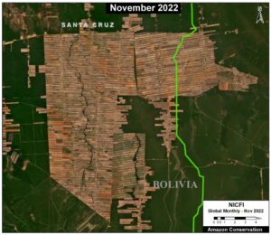
In the first report, MAAP #179, our team documented the soy-driven deforestation of 904,518 hectares (2.2 million acres) over the past 20 years (2001-2021). This is a massive area, similar to the size of the U.S. state of Vermont. Over 100,000 hectares (250,000 acres) were deforested in just the past five years (2017-21).
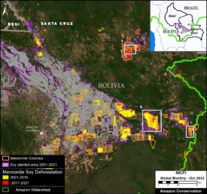
In the second report, MAAP #180, our team incorporated additional data and estimated that Mennonite colonies caused nearly one quarter (23%) of the total soy deforestation over the past 20 years (210,980 hectares, or 521,344 acres) and increased to 33% over just the past 5 years.
These reports are part of a series focused on the Bolivian Amazon through a strategic collaboration between the sister organizations Conservación Amazónica – ACEAA in Bolivia and Amazon Conservation in the U.S.
 Our sister organization in Peru, Conservación Amazónica – ACCA, has joined forces with
 “This tool greatly facilitates the collection and organization of geospatial data in the field at no cost, achieving greater efficiency in information management, reducing processing times and having an intuitive graphical interface that favors the visualization of the collected data. The great thing about this tool is the large number of additional cloud-based plugins that can be included, the great technical support and regular updates it receives”, highlighted Osmar Yupanqui, GIS and Remote Sensing assistant at our Peruvian sister organization, Conservación Amazónica – ACCA and who was responsible for the training.
 Loading...


