MAAP #62: Fire, Rain, And Deforestation in The Peruvian Amazon

In 2016, Peru experienced an intense forest fire season (MAAP #52, MAAP #53). A leading hypothesis was that intense drought facilitated the escape of agricultural burns. To investigate, this report analyzes the dynamic between fires and precipitation over the past 15 years, finding a strong temporal correlation (Image 62a). We also investigate the link between fires and forest loss, finding a spatial correlation.

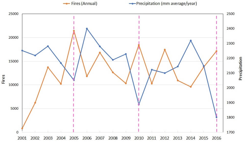
Image 62a. Data: TRMM, FIRMS/NASA, PNCB/MINAM, GLAD/UMD

MAAP #61: Illegal Gold Mining Decreases in Tambopata National Reserve

In the previous MAAP #60, we showed the rapidly increasing illegal gold mining deforestation in the buffer zone of Tambopata National Reserve. In contrast, here we show that the rate of illegal gold mining deforestation is decreasing within Tambopata National Reserve, due to the active interventions by the Peruvian Government. Tambopata is an important protected area in the southern Peruvian Amazon due to its high biodiversity.


Image 61. Data: Planet, MAAP, SERNANP