MAAP #94: Detecting Logging in The Peruvian Amazon With High Resolution Imagery

In MAAP # 85, we showed how medium and high-resolution satellites (such as Landsat, Planet and Sentinel-1) could be used to monitor the construction of logging roads in near-real time.

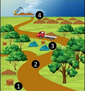
Base Map. Logging Activities. Source: ACCA/ACA.

Here, we show the potential of very high-resolution satellites (such as DigitalGlobe and Planet’s Skysat), to identify the activities associated with logging, including illegal logging.

These activities include (see Base Map):
1. Selective logging of high-value trees,
2. Construction of logging roads (access roads),
3. Logging camps
4. Storage and transport

Next, we show a series of very high-resolution images (>50 centimeters), which allow clear identification of these activities.

Note that we show images of both possible legal logging in authorized areas (Images 1,2,5,6,7,9,10) and confirmed illegal logging in unauthorized areas (Images 3,4,8,11,12).*

Migration in the Amazon: Time to fly away from the cold

Solitary sandpiper (Tringa solitaria) unlike other sandpipers and other migratory birds, do not migrate in large flocks and can be found along the banks of shady creeks. PC: Alex Wiebe

Movement is an essential part of our day-to-day lives. However, this is not only true for us; most species are constant on the move. For some, this is due to continuous changes in their surroundings and others because of their ecology. Most of these movements go unnoticed by us, however, there is one that does not: Bird migration. If you look up into the sky at this time of the year, you may notice the unusually high number of birds flying around. For birds that migrate, they do so twice a year, between their breeding homes habitats and their nonbreeding grounds. Some migrations are large-scale like the Artic tern (Sterna paradisaea) which incredibly manages an annual round-trip of 70 000 km. Others are much shorter, such as altitudinal gradient migration along the Andes.

Migration is the seasonal movement from one region to another influenced by a series of factors. Specifically, bird migration is strongly influenced by the availability of nesting sites and food. In temperate zones, the hours of increased light during the summer allows birds to forage for longer periods. Additionally, because of the lower biodiversity, competition for resources and nesting sites is not as intense. These are appealing conditions to use temperate zones as breeding sites. Yet, as the season ends, food availability and the hours of light decrease, and birds have to find suitable grounds for the rest of the year. The tropics, despite the food abundance throughout the year, are not attractive to some species as breeding grounds because of the intense competition for resources and nesting sites due to the great biodiversity. However, most of these species become temporary residents of the tropics until is time to breed again.

Out of all the bird species in the world 40%, or around 4 000, are regular migrants. However, they are unevenly distributed around the world. In countries in the far north like Canada and Scandinavia, birds migrate southwards during the boreal winter to flee the harsh winter and will only go back until the following spring.

Chivi Vireo  (Vireo chivi) is one of the most widespread and common passerines of South America. This species consists of a complex mosaic of resident and migratory populations. During the austral and boreal winter, there is a seasonal overlap between the resident population and wintering population from the temperate zones.  PC: Alex Wiebe

Migration can take several weeks. Because of this, birds enter a state called hyperphagia before their journey. During this state, they will ingest as much food as possible to build up the fat reserves that will provide them with the energy needed for their journey. Once the migration has started, birds use a combination of senses and cues that are not fully understood, to reach their destination. They can orientate themselves by sensing the Earth´s magnetic field, and by the position of the sun, stars, and landmarks seen during the day. Species do not migrate all at once or in the same way. This is why you can see migrating flocks or individuals at different times of the day and for several months. Each species starts its migration at a specific time and some vary their migration year to year depending on food availability. The beginning of migration is also influenced by changes in the length of daylight. First-time migrators often make the journey on their own, despite the fact that they have never been to their winter home before. Impressively they are able to find them.

To avoid exhaustion and starvation during the thousands of kilometers flight, birds stop to recharge their energy along the way. However, by doing so, they are vulnerable to fall victim to predators. While enduring their journey, migratory birds face further threats like wildfires and storms, which appear to be intensifying due to our changing climate; shortages of resting areas, due to human encroachment; disorientation by city lights; and obstacles such as tall buildings. In 1971, The Ramsar Convention on wetland was agreed as a measure to protect migratory birds. However, each year the population of migratory birds decreases due to habitat loss and degradation in the tropics. By protecting the tropical forests, we are ensuring the well-being of migratory birds and ensure that future generations have the opportunity to this spectacle.


For further reading:

  • Salewski, V. & Bruderer, B. (2007) The evolution of bird migration-a synthesis. Naturwissenschaften 94:268-279.
  • Robbins, C., Sauer, J., Greenberg, R. and Droege, S. (1989) Population declines in North American birds that migrate to the neotropics. Population Biology Vol. 86, pp. 7658-7662.


MAAP #93: Shrinking Primary Forests of The Peruvian Amazon

The primary forests of the Peruvian Amazon, the second largest stretch of the Amazon after Brazil, are steadily shrinking due to deforestation.

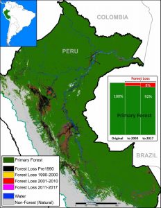
Base Map. Data: SERNANP, IBC, Hansen/UMD/Google/USGS/NASA, PNCB/MINAM, GLCF/UMD, ANA.

Here, we analyze both historic and current data to identify the patterns.

The good news: As the Base Map shows, the Peruvian Amazon is still home to extensive primary forest.* We estimate the current extent of Peruvian Amazon primary forest to be 67 million hectares (165 million acres), greater than the total area of France.

Importantly, we found that 48% of the current primary forests (32.2 million hectares) are located in officially recognized protected areas and indigenous territories (see Annex).**

The bad news: The Peruvian Amazon primary forests are steadily shrinking.

We estimate the original extent of primary forests to be 73.1 million hectares (180.6 million acres). Thus, there has been a historic loss of 6.1 million hectares (15 million acres), or 8% of the original. A third of the historic loss (2 million hectares) has occurred since 2001.

Below, we show three zooms (in GIF format) of the expanding deforestation, and shrinking primary forests, in the southern, central, and northern Peruvian Amazon.