MAAP #137: New Illegal Gold Mining Hotspot In Peruvian Amazon – Pariamanu

In 2019, the Peruvian government launched Operation Mercury to confront the illegal gold mining crisis in the southern Amazonian area known as La Pampa (Madre de Dios region).As a result, deforestation decreased 90% in this critical area (MAAP# 130).

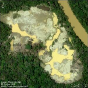
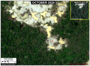
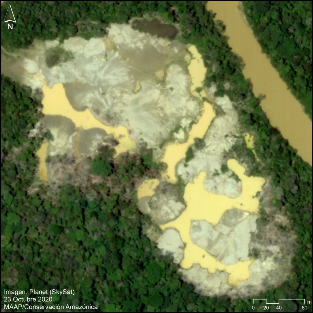
Some illegal gold mining, however, has moved to several new hotspots (Image 1), although at much lower levels.

Image 1. Very high-resolution image of the recent gold mining deforestation (10 hectares) in the new hotspot around the Pariamanu river. Data: Planet (Skysat)

The most emblematic hotspot is located along the Pariamanu River, northeast of La Pampa in the Madre de Dios region (see Base Map, below).

We have documented the gold mining deforestation of 204 hectares (504 acres) in the Pariamanu area from 2017 to the present

This mining activity is clearly illegal because it is located within Brazil-nut forestry concessions, and is outside the permitted mining zone (commonly called the “mining corridor”).

Fortunately, a series of timely actions by the Peruvian Government has minimized the irreversible damage along the Pariamanu (see below).

The objective of this report is to present Pariamanu as an emblematic case that links technology with the rapid response action of public entities to address illegal activity in the Amazon.

It also represents a concrete case of strategic collaboration between civil society and the government to try and achieve zero illegal deforestation (and avoided deforestation).


Pariamanu

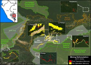
Base Map

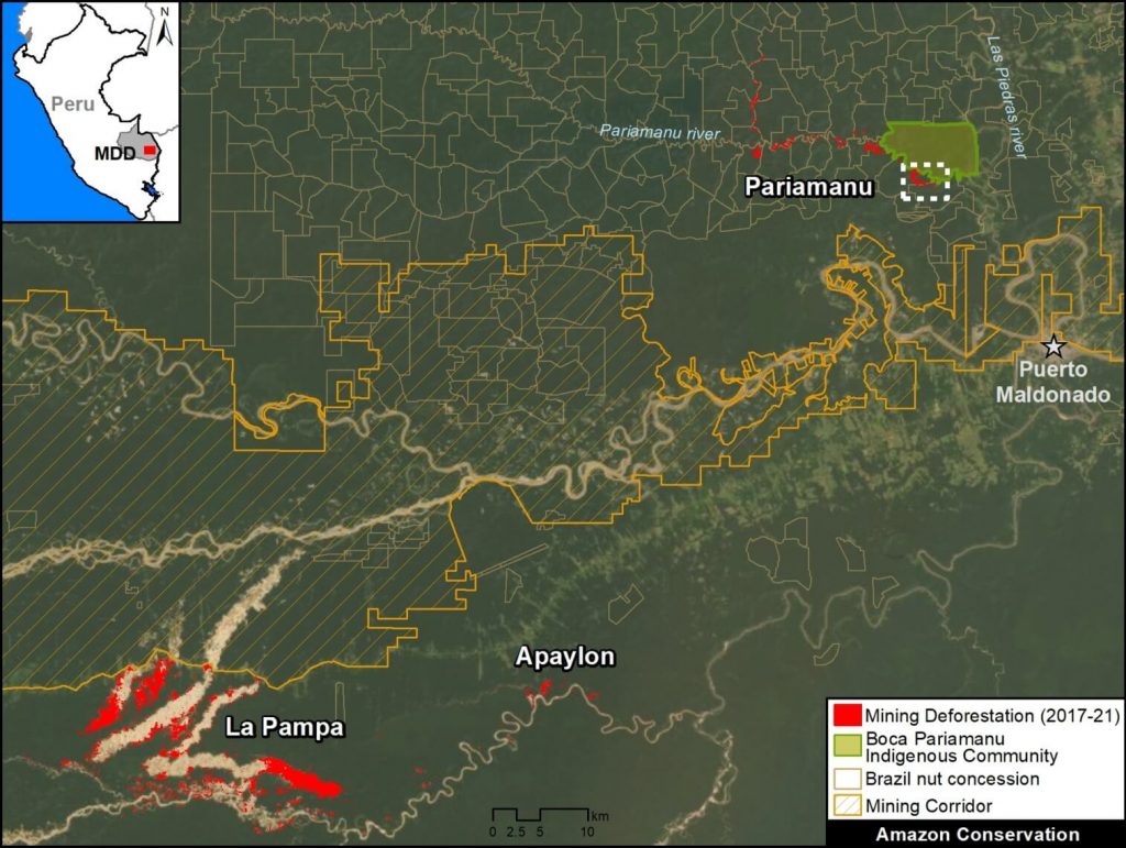
Base Map. Illegal gold mining deforestation along the Pariamanu river, in the context of La Pampa. Data: MAAP.

The Base Map shows the location of illegal gold mining along the Pariamanu River, in the southern Peruvian Amazon (Madre de Dios region).

For context, La Pampa (the previous epicenter of illegal mining) and the regional capitol city of Puerto Maldonado are inlcuded. We also show another new illegal mining hotspot next to La Pampa, known as Apaylon.

In total, we have documented the deforestation of 204 hectares (504 acres) of primary forest caused by illegal gold mining in Pariamanu since 2017, indicated in red.

Note that this deforestation is located within Brazil nut forestry concessions and outside the “mining corridor,” thus clearly indicating its illegality.


Satellite Video: Illegal Gold Mining Deforestation in Pariamanu

We present a satellite image video showing an example of illegal gold mining in the Pariamanu area. These images show the deforestation of 71 hectares (175 acres) between 2016 (first image) and 2021 (last image), in the area indicated by the white inset box in the Base Map above. Note that each image is from July of each year (2016-20), with the exception of 2021 which shows January and March.

Satellite image video. Data: Planet.

Planet link: https://www.planet.com/stories/illegal-gold-mining-in-southern-peruvian-amazon-pa-6DfO4KuGg


MAAP Reports & Government Action

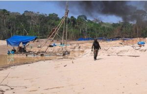
Operativo en Pariamanu, septiembre del 2020. Foto: FEMA Madre de Dios.

The first MAAP report about Pariamanu was published in November 2016, where we described “the start of mining in a new area” (MAAP #50). We found the mining-caused deforestation of 69 hectares (170 acres) on the banks of the Pariamanu river.

In January 2020, we published the second MAAP report about Pariamanu, documenting that the mining deforestation increased to 99 hectares (245 acres) (MAAP # 115). In this report, we warned that there were indications that some miners displaced by Operation Mercury (in February 2019) have moved to this area.

In response to this situation, the Peruvian Government, led by the Special Prosecutor for Environmental Matters (known as FEMA), carried out a series of field operations in 2020 (MayAugust and September, respectively), as an extension of Operation Mercury focused on cracking down on the illegal mining in Pariamanu.

The operations were effective in destroying mining equipment and sending a strong message that the government was engaged in this area.

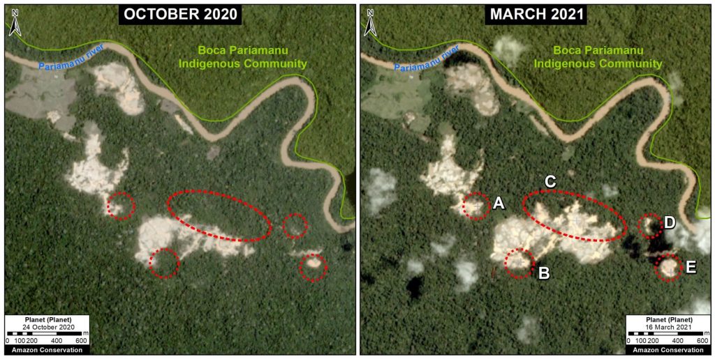
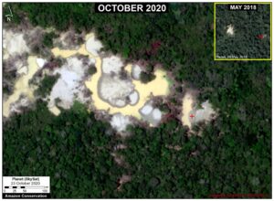
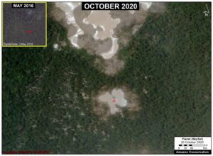
However, we found that gold mining deforestation continued in several small areas between October 2020 and March 2021 (see Image 2), reaching the new total of 204 hectares (504 acres).

Fortunately, the government continues to respond effectively. Most recently (March 19, 2021), FEMA and the Peruvian Coast Guard carried out a new operation in Pariamanu, finding an illegal mining camp and equipment.

As mentioned above, the objective of this section (and this report) is to present Pariamanu as an emblematic case that links technology with the rapid response action of public entities to address illegal activity in the Amazon. It also represents a concrete case of strategic collaboration between civil society and the government to try and achieve zero illegal deforestation (and avoided deforestation).


Image 2. Data: Planet, MAAP.


Acknowledgments

We thank S. Novoa (ACCA), G. Palacios (ACA), and A. Felix, K. Nielsen, A. Caceres, I. Canelo, J. Carlos Guerra, O. Liao, y H. Che Piu from USAID’s PREVENT Project, for their helpful comments on this report.

This report was conducted with technical assistance from USAID, via the Prevent project. Prevent is an initiative that is working with the Government of Peru, civil society, and the private sector to prevent and combat environmental crimes in Loreto, Ucayali and Madre de Dios, in order to conserve the Peruvian Amazon.

This publication is made possible with the support of the American people through USAID. Its content is the sole responsibility of the authors and does not necessarily reflect the views of USAID or the US government.

This work was also supported by NORAD (Norwegian Agency for Development Cooperation), ICFC (International Conservation Fund of Canada), and EROL Foundation.


Citation

Finer M, Mamani N (2021) New Illegal Gold Mining Hotspot in Peruvian Amazon – Pariamanu. MAAP: 137.

Download PDF of this article >>


MAAP #130: Illegal Gold Mining Down 78% In Peruvian Amazon, But Still Threatens Key Areas

As part of USAID’s Prevent Project (dedicated to combating environmental crimes in the Amazon), we conducted an updated analysis of illegal gold mining deforestation in the southern Peruvian Amazon.In early 2019, the Peruvian government launched Operation Mercury, an unprecedented crackdown on the rampant illegal gold mining in the region.The Operation initially targeted an area known as La Pampa, the epicenter of the illegal mining. In 2020, it expanded to surrounding critical areas.

Image 1. Very high resolution image of recent gold mining deforestation along the Pariamanu River. Data: Planet (Skysat).

In this report, we compare rates of gold mining deforestation before vs after Operation Mercury at six key sites (see Base Map and Methodology below).

We report four major results:

1) Gold mining deforestation decreased 90% in La Pampa (the most critical mining area) following Operation Mercury.

2) Gold mining deforestation increased in three key areas –Apaylon, Pariamanu, and Chaspa – indicating that some miners expelled from La Pampa moved to surrounding areas. The Peruvian government, however, has recently carried out major interventions in all three of these areas.

3) Overall, gold mining deforestation decreased 78% across all six sites following Operation Mercury.

4) Illegal mining does persist, however. We documented 1,115 hectares of gold mining deforestation across all six sites since Operation Mercury (but, compared to 6,490 hectares before the Operation).

Below, we provide a more detailed breakdown of the major results across all six sites. We also present a series of very high resolution satellite images (Skysat) of the recent gold mining deforestation.


Base Map – 6 Major Illegal Gold Mining Sites

The Base Map illustrates the results across the six major gold mining fronts in the southern Peruvian Amazon. Red indicates gold mining deforestation post Operation Mercury (March 2019 – October 2020), while yellow indicates the pre Operation baseline (January 2017 – February 2019).

Base Map. Major gold mining fronts in the southern Peruvian Amazon before (yellow) and after (red) Operation Mercury. Data: MAAP.

In La Pampa, we documented the dramatic loss of 4,450 hectares within the buffer zone of Tambopata National Reserve (Madre de Dios region) prior to Operation Mercury. Following the Operation, we confirmed the loss of 300 hectares. Note the main mining front in the core of the buffer zone has essentially been stopped, with most recent activity further north near the Interoceanic Highway.

In neighboring Alto Malinowski, located in the buffer zone of Bahuaja Sonene National Park (Madre de Dios region), we documented the loss of 1,558 hectares prior to Operation Mercury. Following the Operation, we confirmed the loss of 419 hectares.

In Camanti, located in the buffer zone of Amarakaeri Commuanl Reserve, we documented the loss of 336 hectares prior to Operation Mercury. Following the Operation, we confirmed the loss of 105 hectares.

In Pariamanu, located in the primary forests along the Pariamanu River (Madre de Dios region), we documented the loss of 72 hectares prior to Operation Mercury. Following the Operation, we confirmed the loss of 98 hectares. In response, the government conducted a major intervention in August 2020.

In Apaylon, located in the buffer zone Tambopata National Reserve (Madre de Dios region), we documented the loss of 73 hectares prior to Operation Mercury. Following the Operation, we confirmed the loss of 78 hectares. In response, the government has conducted a series of interventions in the area during 2020.

Chaspa, located in the buffer zone of Bahuaja Sonene National Park (Puno region), represents a unique case of a new gold mining front that appeared following Operation Mercury. Starting in September 2019, we documented the deforestation of 113 hectares impacting the Chaspa River watershed. In response, the government conducted a major intervention in October 2020.


Gold Mining Deforestation Trends

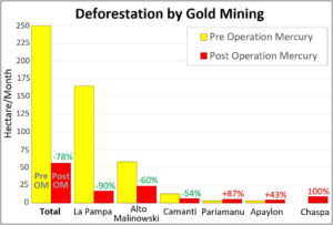
The following chart illustrates that gold mining deforestation fronts decreased following Operation Mercury in the three largest fronts (La Pampa, Alto Malinowski, and Camanti), and increased in three smaller areas (Pariamanu, Apaylon, and Chaspa). Thus, overall gold mining deforestation decreased 78% across all six major sites following Operation Mercury.

Table 1. Rates of gold mining deforestation before (orange) and after (red) Operation Mercury. Data: MAAP.


In La Pampa, the gold mining deforestation averaged 165 hectares per month prior to Operation Mercury. Following the Operation, the deforestation dropped to 17 hectares per month, an overall 90% decrease.

In Alto Malinowski, the gold mining deforestation dropped from 58 hectares per month to 23 hectares per month following Operation Mercury, an overall 60% decrease.

In Camanti, the gold mining deforestation dropped from 12.5 hectares per month to 6 hectares per month following Operation Mercury, an overall 54% decrease.

In Pariamanu, the gold mining deforestation increased from 2.8 hectares per month to 5 hectares per month following Operation Mercury, an overall 87% increase.

In Apaylon, the gold mining deforestation increased from 2.8 hectares per month to 4 hectares per month following Operation Mercury, an overall 43% increase.

Chaspa, located in the buffer zone of Bahuaja Sonene National Park, represents the unique case of a new gold mining front that appeared following Operation Mercury (8.5 hectares per month).


Very High Resolution Satellite Imagery (Skysat)

We recently tasked very high resolution satellite imagery (Skysat, 0.5 meter) for the major illegal gold mining areas. Below, we present a series showing some of the highlights from these images. Note that insets (in the upper corner of each image) show the same area before the mining activity (see red points as a reference).

Pariamanu

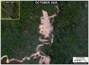
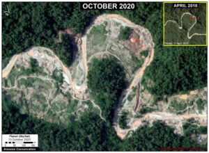
The following two images show the expansion of new gold mining areas into the primary rainforests near the Pariamanu River (Madre de Dios region).

Image 2. Expansion of new gold mining areas into the primary rainforests near the Pariamanu River (Madre de Dios region). Data: Planet.


Image 3. Expansion of new gold mining areas into the primary rainforests near the Pariamanu River (Madre de Dios region). Data: Planet.

La Pampa

The following image shows the expansion of a new gold mining area in the northern part of La Pampa.

Image 4. Expansion of a new mining area in the northern part of La Pampa (Madre de Dios region). Data: Planet, Maxar.


Chaspa

The following image shows the sudden appearance of a new gold mining front along the Chaspa River (Puno region).

Image 5. New gold mining front along the Chaspa River (Puno region). Data: Planet (Skysat).


Camanti

The following image shows the recent expansion of gold mining deforestation in the buffer zone of Amarakaeri Communal Reserve (Cusco region).

Image 6. Recent expansion of gold mining deforestation in the buffer zone of Amarakaeri Communal Reserve (Cusco region). Data: Planet (Skysat).


Methodology

We analyzed high-resolution imagery (3 meters) from the satellite company Planet obtained from their interface Planet Explorer. Based on this imagery, we digitized gold mining deforestation across six major sites: La Pampa, Alto Malinowski, Camanti, Pariamanu, Apaylon, and Chaspa. These were identified as the major active illegal gold mining deforestation fronts based on analysis of automated forest loss alerts generated by University of Maryland (GLAD alerts) and the Peruvian government (Geobosques) and additional land use layers. The area referred to as the “mining corridor” is not included in the analysis because the issue of legality is more complex.

Across these six sites, we identified, digitized, and analyzed all visible gold mining deforestation between January 2017 and the present (October 2020). We defined before Operation Mercury as data from January 2017 to February 2019, and after Operation Mercury as data from March 2019 to the present. Given that the former was 26 months and the latter 20 months, during the analysis the data was standardized as gold mining deforestation per month.

The data is updated through October 2020.


Acknowledgments

We thank A. Felix (DAI), S. Novoa (ACCA), and G. Palacios for their helpful comments on this report.

This report was conducted with technical assistance from USAID, via the Prevent project. Prevent is an initiative that is working with the Government of Peru, civil society, and the private sector to prevent and combat environmental crimes in Loreto, Ucayali and Madre de Dios, in order to conserve the Peruvian Amazon.

This publication is made possible with the support of the American people through USAID. Its content is the sole responsibility of the authors and does not necessarily reflect the views of USAID or the US government.

USAID logo

Citation

Finer M, Mamani N (2020) Illegal Gold Mining Down 79% in Peruvian Amazon, But Still Threatens Key Areas. MAAP: 130.

Download PDF of this article >>

MAAP#121: Reduction Of Illegal Gold Mining In The Peruvian Amazon

Thanks to the support of the USAID, via the Prevent Project, dedicated to the prevention and combat of environmental crimes in the Amazon, we conducted a detailed analysis of recent illegal gold mining deforestation in the southern Peruvian Amazon.

The objective is to understand the trends from early 2017 to June 2020 (which includes the first part of the mandatory quarantine issued by the Peruvian government as of March 16, 2020 due to the coronavirus pandemic).

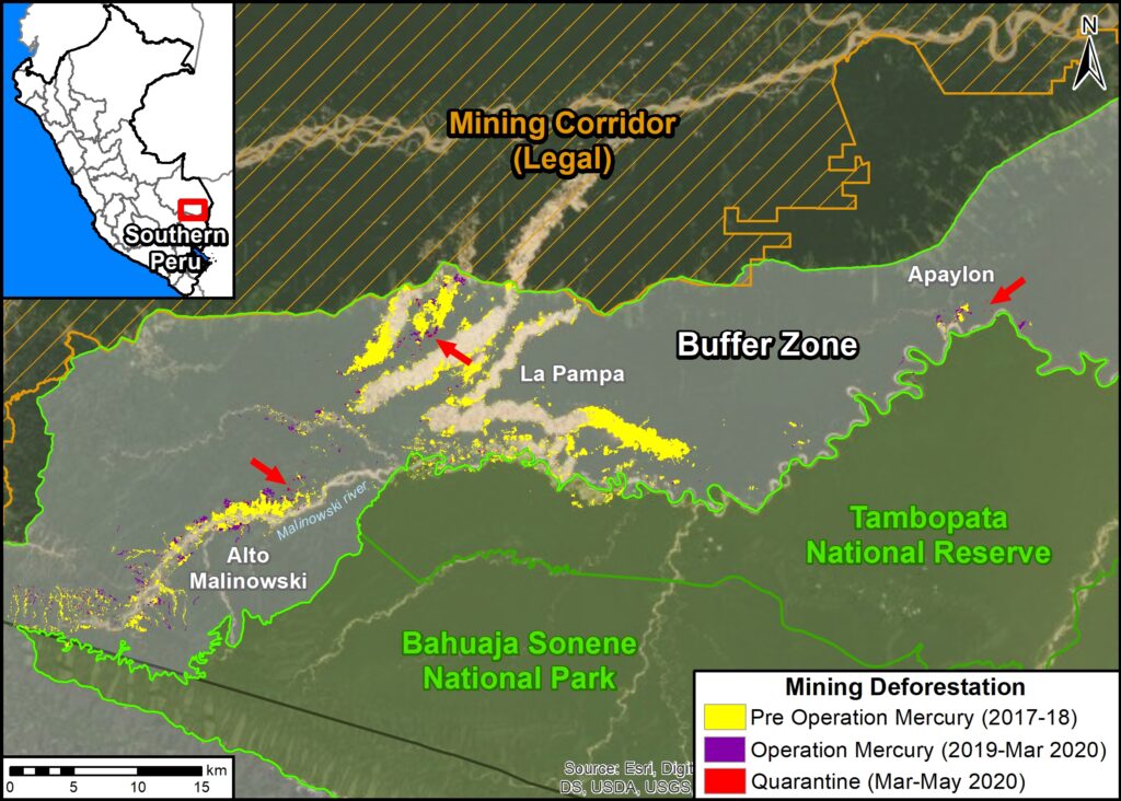
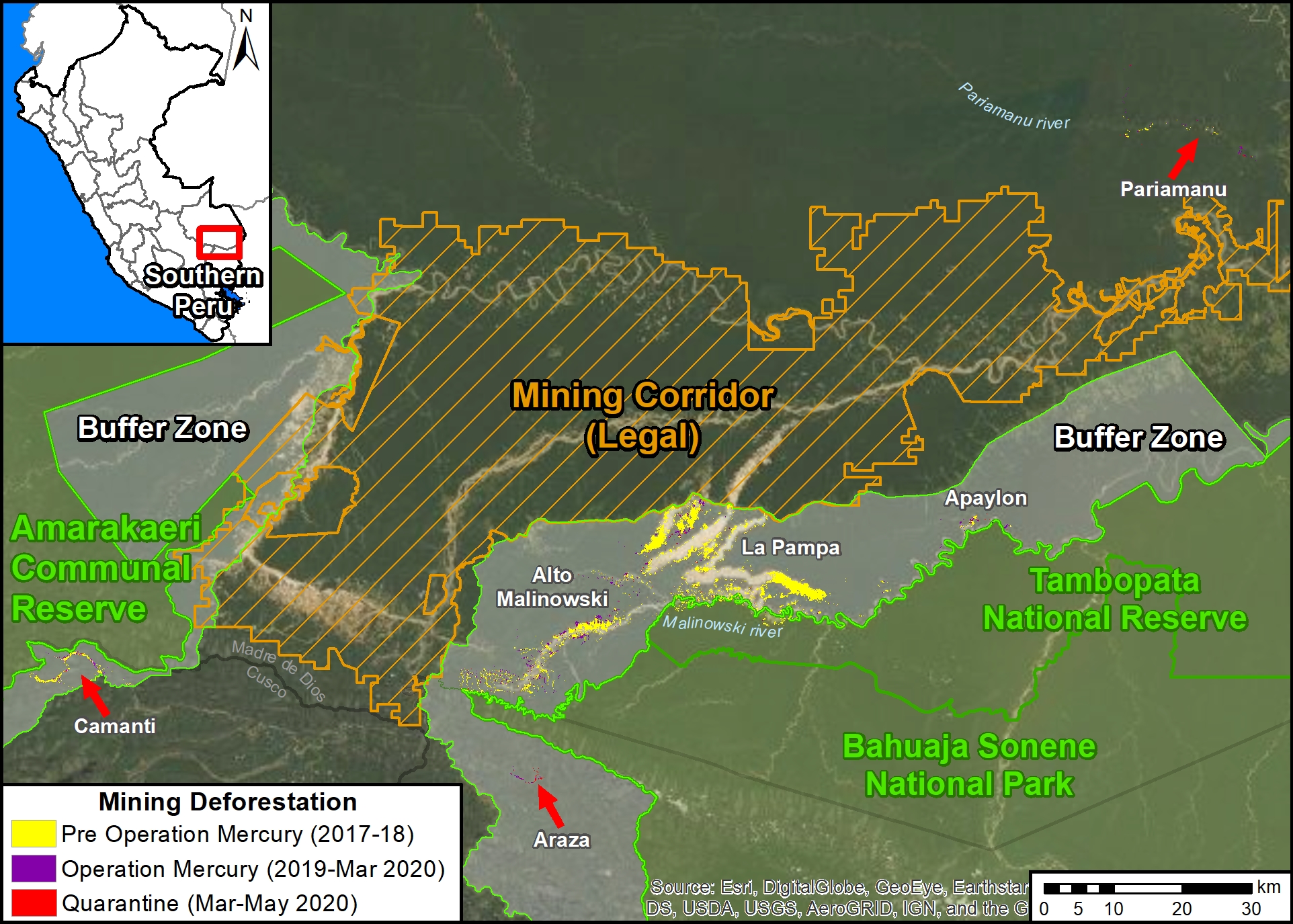
Base Map. Illegal gold mining deforestacion in the protected area buffer zones of the southern Peruvian Amazon, 2017-2019. Data: MAAP. Click to enlarge image.

We focus on the buffer zones of two protected areas in the Madre de Dios region: Tambopata National Reserve and Bahuaja Sonene National Park (see Base Map).*

This area includes La Pampa, the current highest intensity illegal mining zone in the country. In February 2019, the Peruvian government launched Operation Mercury  to confront the illegality in La Pampa and surrounding areas.

The Base Map shows that gold mining deforestation in La Pampa decreased over 90% following Operation Mercury.

However, illegal gold mining does continue after Operation Mercury (including during the coronavirus state of emergency), but at lower rates. Thus, current snapshots may be misleading and recent context is important.

On the Base Map, the red arrows indicate the areas with the most recent illegal activity (click the image to enlarge). See below for more details.


Main Results

Table 1. Illegal gold mining deforestation before (yellow) and after (red) Operation Mercury in the buffer zones of Madre de Dios. Data: MAAP.

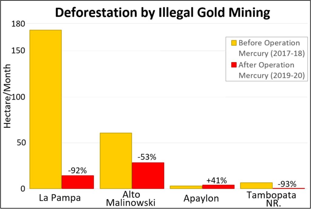
The Base Map and Table 1 illustrate the following key results:

  • In La Pampa, we documented mining deforestation of 173 hectares (428 acres) per month before Operation Mercury (January 2018 – February 2019). After the intervention, deforestation was reduced to 14 hectares (36 acres) per month (March 2019 – May 2020), a decrease of 92%.
    .
  • Upstream, in the Alto Malinowski, we documented the mining deforestation of 61 hectares (150 acres) per month before Operation Mercury. After the intervention, deforestation was reduced to 28 hectares (69 acres) per month, a decrease of 53%.
    .
  • Downstream, in the Apaylon area, we documented the mining deforestation of 2.9 hectares (7 acres) per month, before Operation Mercury. After the intervention, deforestation increased to 4 hectares (10 acres) per month, an increase of 41%. Apaylon is main area in the buffer zone where deforestation has increased.
    .
  • Within Tambopata National Reserve, we documented the mining deforestation of 6.5 hectares (16 acres) per month, before Operation Mercury. After the intervention, deforestation was reduced to 0.5 hectares (1.2 acres) per month, a decrease of 93%.
    .
  • Overall, illegal gold mining does continue in the buffer zones of Madre de Dios, but at lower rates than the previous two years. We documented the gold mining deforestation of 797 hectares (1,670 acres) after Operation Mercury.
    .
  • Regarding the speculation that illegal activity would increase during the coronavirus pandemic, we have not documented any major increase or surge in the buffer zones of Madre de Dios.* Illegal mining does continue, however, we documented the deforestation of 80 hectares (198 acres) during the quarantine.


Reduction of 90% in La Pampa

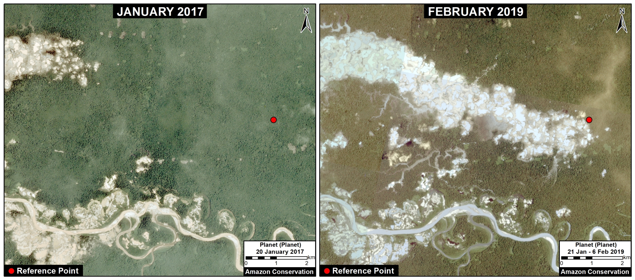
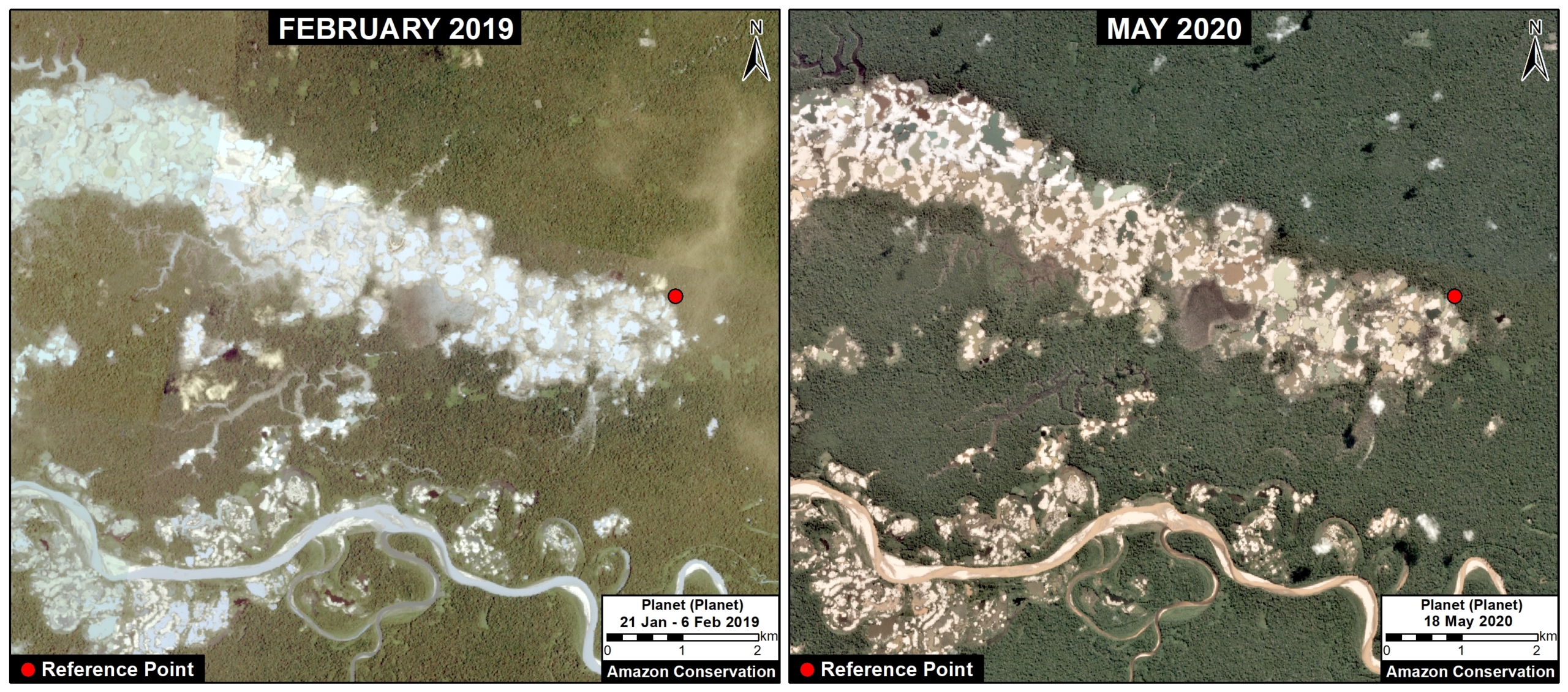
The following images show the major decrease in gold mining deforestation in La Pampa after Operation Mercury. Image 1 shows the rapid deforestation before Operation Mercury, between January 2017 (left panel) and February 2019 (right panel). Image 2 shows how the deforestation decreased after Operation Mercury, between February 2019 (left panel) and May 2020 (right panel). The red dot represents a reference point between the images.

Image 1. Rapid gold mining deforestation in La Pampa before Operation Mercury, between January 2017 (left panel) and February 2019 (right panel). Data: Planet.
Image 2. Mining deforestation decreased in La Pampa after Operation Mercury, between February 2019 (left panel) and May 2020 (right panel). Data: Planet.


Displaced Miners?

There has also been speculation that the focus of Operation Mercury in La Pampa would lead to illegal miners moving to other areas.* Base Map 2 shows two of the most threatened areas: Camanti and Pariamanu.

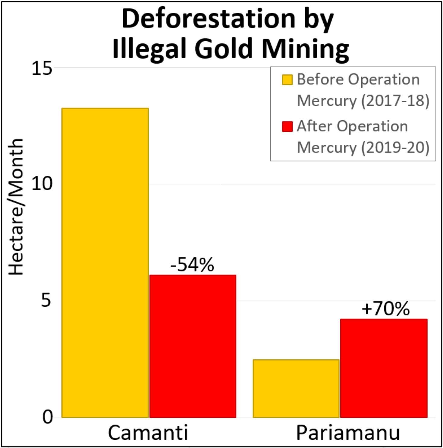
Table 2. Deforestation by illegal gold mining before (yellow) and after (red) Operation Mercury in two other threatened areas. Data: MAAP.

These are the main results for these two areas:

  • In Camanti (located in the buffer zone of Amarakaeri Communal Reserve), we documented the gold mining deforestation of 13.3 hectares (33 acres) per month before Operation Mercury. After the intervention, deforestation was reduced to 6.1 hectares (15 acres) per month, a decrease of 54%.
    .
  • In Pariamanu, we documented  the mining deforestation of 2.5 hectares (6 acres) per month before Operation Mercury. After the intervention, it increased to 4.2 hectares (10 acres) per month, an increase of 70%.
  • In summary, illegal gold mining continues in these two areas outside La Pampa. We documented the mining deforestation of 175 hectares (432 acres) after Operation Mercury (including 22 hectares during the pandemic). There is some evidence that miners are being displaced to Pariamanu, but there has not been a surge in Camanti.
Base Map 2. Main mining areas in the south of the Peruvian Amazon. Click to enlarge image.

Statement of the Peruvian Protected Area Agency (SERNANP)

El Servicio Nacional de Áreas Naturales Protegidas por el Estado (SERNANP) nos ha comunicado lo siguiente:

  • La actividad de control y vigilancia en la Reserva Nacional Tambopata es permanente y las autoridades (SERNANP, Policía Nacional del Perú, Fiscalías Especializadas en Materia Ambiental, y Marina de Guerra del Perú) continúan interviniendo a todas las actividades de minería ilegal, manteniendo el 100%.
  • Las zonas de amortiguamiento son espacios que están sujetos a la intervención de las autoridades de la Operación Mercurio (no del SERNANP). Se han realizado intervenciones continuas e interdicciones tanto en  las zonas indicadas en el reporte, como en Apaylon y Camanti.
    ,
  • Cabe mencionar que la Operación Mercurio, durante el 2019 y sobre todo en el 2020 (Incluyendo el período de cuarentena) ha ampliado sus operativos mas allá de la Pampa, lo cual explica porque en Camanti las cifras también se ha reducido.  En el segundo semestre de 2020 y en el 2021, se espera que los operativos es amplíen a otras zonas de Madre de Dios.


*Notes


Acknowledgments

We thank R. Segura, M. Castro, E. Ortiz, M. Silman, M. E. Gutierrez, S. Novoa, H. Balbuena, M. Allemant, and G. Palacios for their helpful comments on this report.

This report was conducted with technical assistance from USAID, via the Prevent project. Prevent is an initiative that, over the next 5 years, will work with the Government of Peru, civil society, and the private sector to prevent and combat environmental crimes in Loreto, Ucayali and Madre de Dios, in order to conserve the Peruvian Amazon.

This publication is made possible with the support of the American people through USAID. Its content is the sole responsibility of the authors and does not necessarily reflect the views of USAID or the US government.

USAID logo

Citation

Finer M, Mamani N (2020) Reduction of Illegal Gold Mining in the Peruvian Amazon. MAAP:

MAAP #116: Amazon Gold Mining, Part 2: Brazil

Base Map. Major gold mining deforestation zones across the Amazon. Data: MAAP.

We present the second part of our series on Amazon gold mining, with a focus on the Brazil*

Specifically, we focus on mining in indigenous territories in the Brazilian Amazon.

Extractive activities, such as gold mining, are constitutionally not permitted on indigenous lands, but the Bolsonaro administration is advancing a bill (PL 191) that would reverse this.

The Base Map indicates three Brazilian indigenous territories where we identified recent major gold mining deforestation:

  1. Munduruku (Pará)
  2. Kayapó (Pará)
  3. Yanomami (Roraima)

We documented the gold mining deforestation of 10,245 hectares (25,315 acres) across all three indigenous territories over the past three years (2017 – 2019). That is the equivalent of 14,000 soccer fields.

Below, see more detailed data, including a series of satellite GIFs of the recent gold mining deforestation in each territory.

*Part 1 looked at the Peruvian Amazon (see MAAP #115). For information on Suriname, see this report from Amazon Conservation Team. For all other countries see this resource from RAISG.

MAAP #115: Illegal Gold Mining in the Amazon, Part 1: Peru

Base Map. The main illegal gold mining areas in the Peruvian Amazon. Data: MAAP.

In a new series, we highlight the main illegal gold mining frontiers in the Amazon.

Here, in part 1, we focus on Peru. In the upcoming part 2, we will look at Brazil.

The Base Map indicates our focus areas in Peru*:

  • Southern Peru (A. La Pampa, B. Alto Malinowski, C. Camanti, D. Pariamanu);
  • Central Peru (E. El Sira).

Notably, we found an important reduction in gold mining deforestation in La Pampa (Peru’s worst gold mining area) following the government’s launch of Operation Mercury in February 2019.

Illegal gold mining continues, however, in three other major areas of the southern Peruvian Amazon (Alto Malinowski, Camanti, and Pariamanu), where we estimate the mining deforestation of 5,300 acres (2,150 hectares) since 2017.

Of that total, 22% (1,162 acres) occurred in 2019, indicating that displaced miners from Operation Mercury have NOT caused a surge in these three areas.

Below, we show a series of satellite videos of the recent gold mining deforestation (2017-19) in each area.

*Recent press reports indicate the increase in illegal gold mining activity in northern Peru (Loreto region), along the Nanay and Napo Rivers, but we have not yet detected associated deforestation.

MAAP #104: Major Reduction In Illegal Gold Mining From Peru’s Operation Mercury

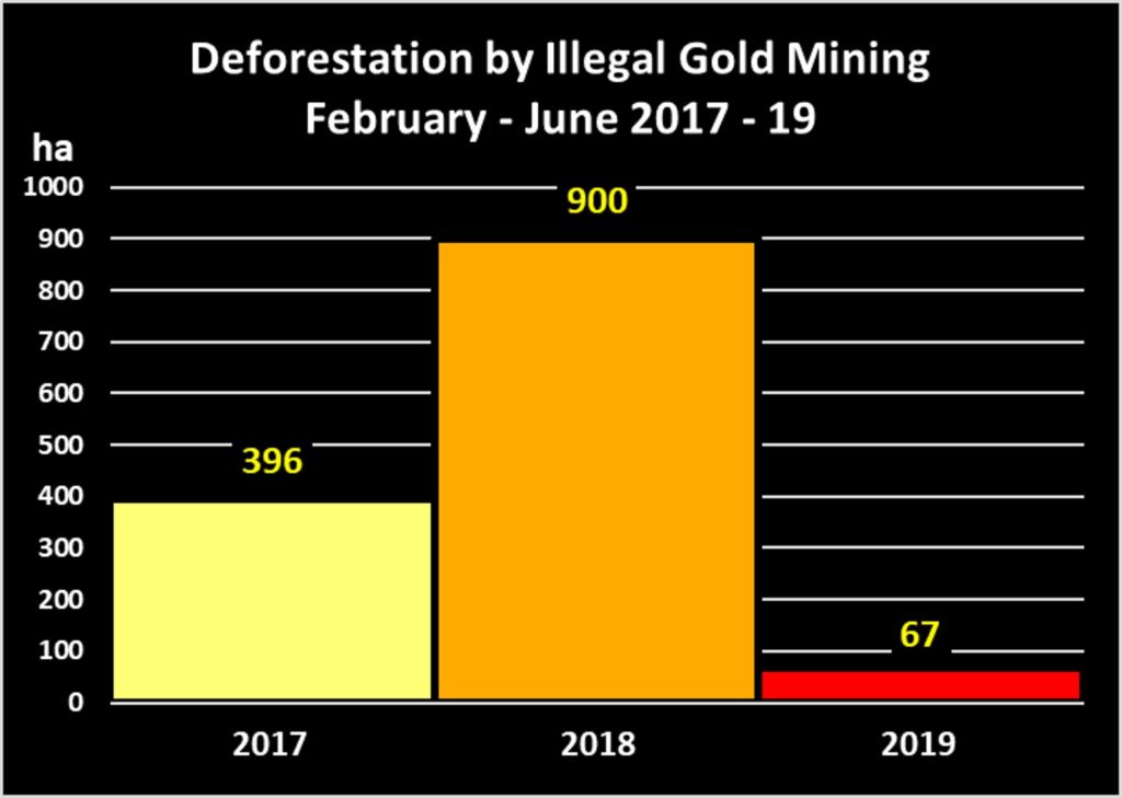
Graph 1. Illegal gold mining deforestation in La Pampa, 2017-19. Data- ACA, MAAP.

In February 2019, the Peruvian government launched Operation Mercury (Operación Mercurio), a major multi-sectoral crackdown on the illegal gold mining crisis in the area known as La Pampa,* located  in the southern Peruvian Amazon (Madre de Dios region). Note that this area is not within Tambopata National Reserve, but in its buffer zone.

In this report, we present the results of our analysis on the initial impacts of this Operation.

We found a major reduction in gold mining deforestation in La Pampa in 2019, compared to the same time period (February – June) of the previous two years (see Graph 1).

In fact, the gold mining deforestation decreased 92% between 2018 (900 hectares) and 2019 (67 hectares), representing the situation before and after the start of Operation Mercury.

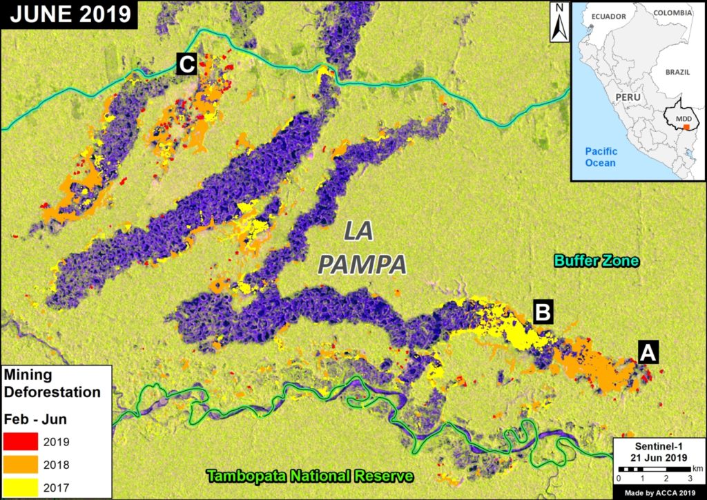
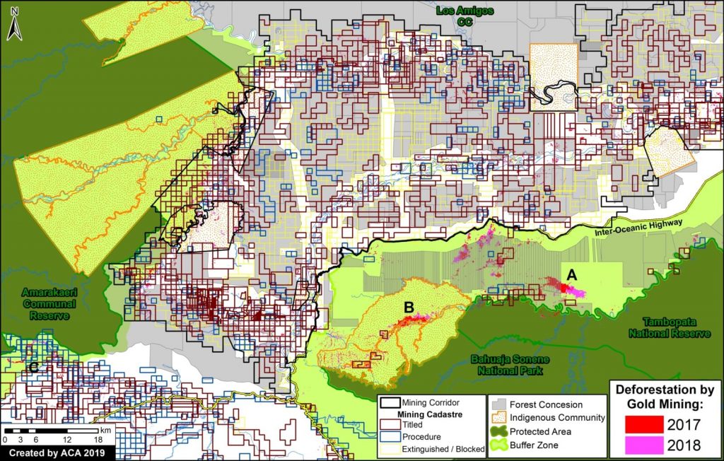
The Base Map illustrates how the expansion of gold mining deforestation greatly dropped in 2019 compared to the two previous years, especially in the eastern front. The letters (A-C) correspond to the location of the Zooms, below.

The analysis also reveals, however, that the gold mining deforestation in La Pampa has not yet been completely eradicated and continues in numerous remote and isolated areas.


Base Map. Illegal gold mining deforestation in La Pampa. Data- ACCA, MAAP, SERNANP

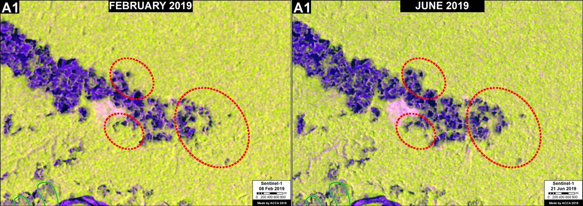
Zoom A1 shows the critical eastern front of the gold mining deforestion between February (left panel) and June (right panel) 2019, the first five months of Operation Mercury. While the rapid eastward expansion of the front has greatly decreased, the red circles indicate areas where we have detected isolated mining activity.

Zoom A1. Eastern front of the gold mining deforestation in La Pampa. Data- ESA, MAAP

High Resolution Zooms


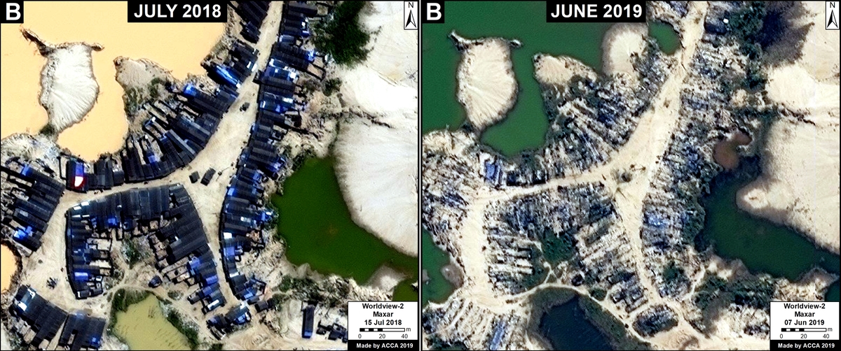
Zoom B shows the eradication of one of the biggest mining camps in La Pampa between 2018 (left panel) and 2019 (right panel).

Zoom B. Eradication of major gold mining camp. Data- Maxar

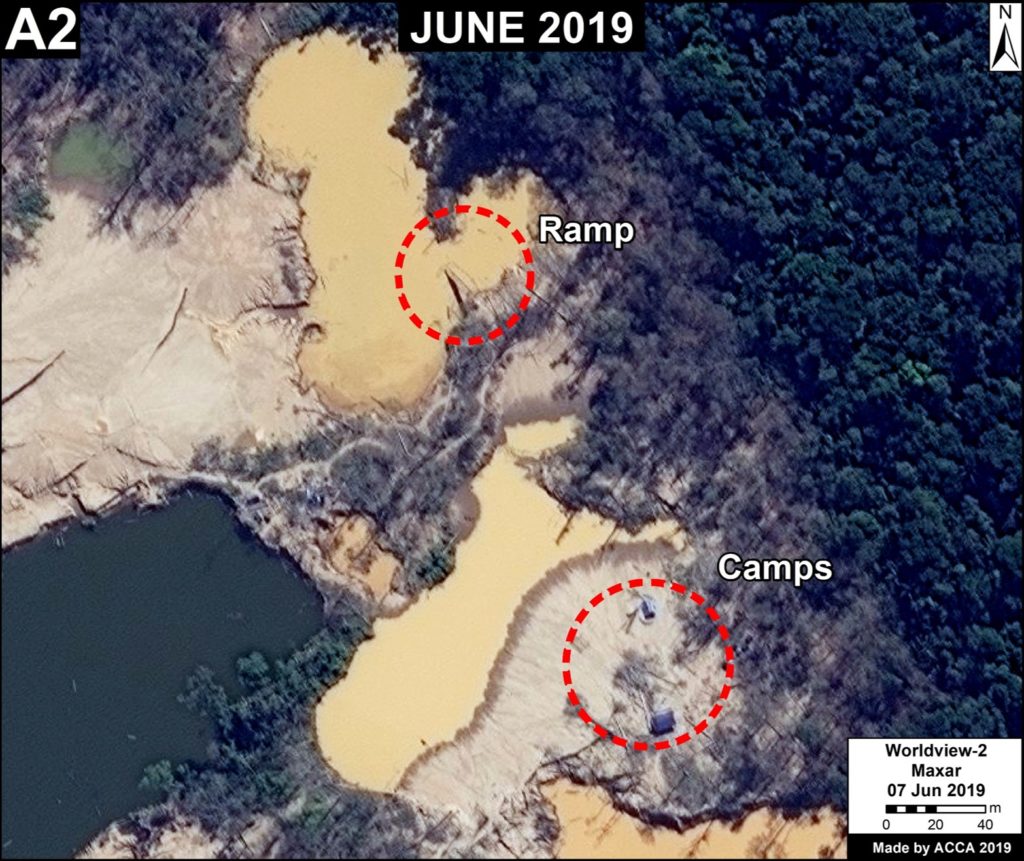
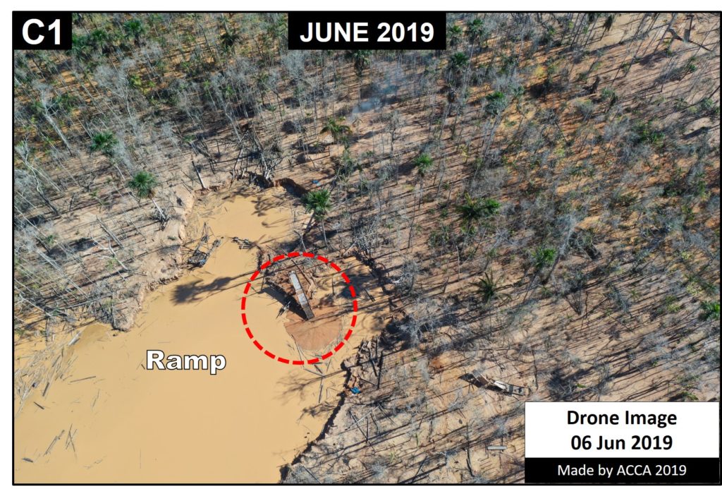
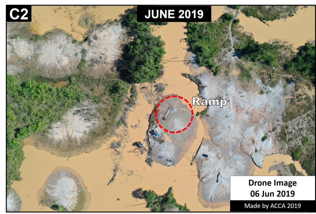
The following Zooms show examples of the persistence of isolated illegal gold mining activity and infrastructure in La Pampa, with recent (June 2019) high resolution satellite and drone images. The letters (A2, C1, C2) correspoind to the Base Map, above.

Zoom A2. Data- Maxar, MAAP

Zoom C1. Data- ACCA
Zoom C1. Data- ACCA

Zoom C2. Data- ACCA.


Google Earth Engine App

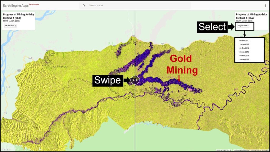
We present a new app, developed with Google Earth Engine, that allows an interactive visualization of the evolution of gold mining deforestation in La Pampa. The app allows the user to take advantage of Google’s powerful computers to compare (with a slider) different dates from a large archive of Sentinel-1 satellite images (see screenshot, below). Sentinel-1 is radar, so there are no clouds in the images.

https://luciovilla.users.earthengine.app/view/mining-monitoring-by-sar-sentinel-1

Screen shot of the app. Data- ESA, MAAP


Notes 

*La Pampa is the sector located in the buffer zone of Tambopata National Reserve, delimited by the northern boundary of the reserve, the Malinowski River and the Interoceanic Highway.

Full study area of La Pampa (shaded). Data: ACCA, MAAP.

Acknowledgements

We thank S. Novoa (ACCA), H. Balbuena (ACCA), E. Ortiz (AAF), T. Souto (ACA), P. Rengifo (ACCA), A. Condor (ACCA), y G. Palacios for helpful comments on earlier drafts of this report.

This work supprted by the following funders:  Norwegian Agency for Development Cooperation (NORAD), International Conservation Fund of Canada (ICFC), MacArthur Foundation, Metabolic Studio, and Global Forest Watch Small Grants Fund (WRI).

Citation

Villa L, Finer M (2019) Major Reduction in Illegal Gold Mining from Peru’s Operation Mercury. MAAP: 104.

MAAP #96: Gold Mining Deforestation At Record High Levels In Southern Peruvian Amazon

Gold mining deforestation has been at record high levels in both 2017 and 2018 in the southern Peruvian Amazon.

Based on an analysis of nearly 500 high-resolution satellite images (from Planet and DigitalGlobe), we estimate the deforestation of 18,440 hectares across southern Peru during these last two years. That is equivalent to 45,560 acres (or 34,400 American football fields) in just two years.

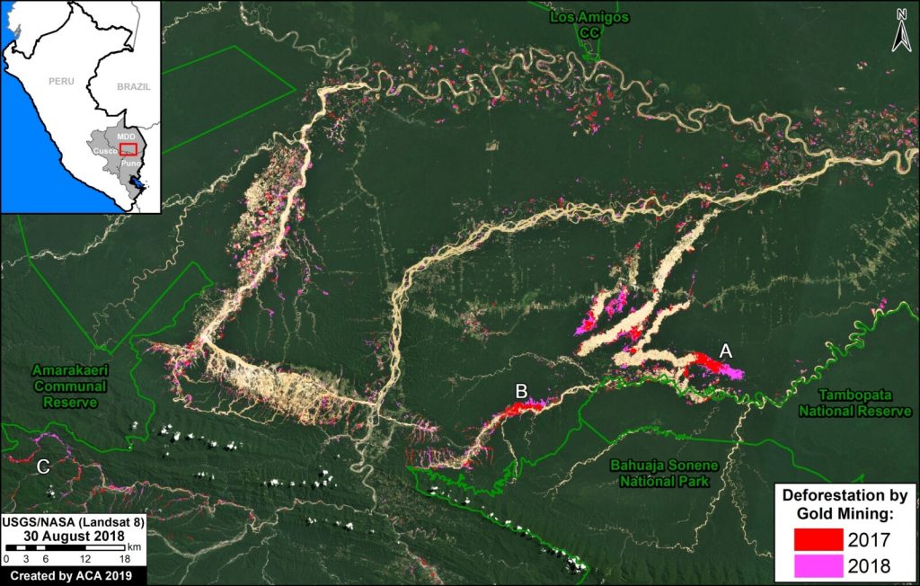
The Base Map highlights this recent deforestation, with 2017 in red and 2018 in pink. The Reference Map in Annex 1 shows our full study area.

Base Map. Gold mining deforestation in southern Peruvian Amazon. Data- USGS/NASA, MAAP, SERNANP

2017 had the highest gold mining deforestation on record at the time: 9,160 hectares (22,635 acres). According to recent research led by CINCIA (Centro de Innovación Científica Amazónica), this was the highest annual total on record dating back to 1985*.

In 2018, we found the gold mining deforestation was even higher: 9,280 hectares (22,930 acres).

Thus, combined, 2017-18 had the highest two-year deforestation total on record: 18,440 hectares (45,565 acres).

Note the location of Zooms (A-C) shown in greater detail below. These zooms represent three of the most threatened areas: A) La Pampa, B) Upper Malinowski, and C) Camanti.

Click (or right click) to enlarge (or download) images.

*CINCIA reports 9,860 hectares of gold mining deforestation in 2017 (CINCIA 2018, Caballero Espejo et al 2018), an estimate even higher than ours.


Zoom A: La Pampa

Image A shows the gold mining deforestation of 1,685 hectares (4,164 acres) between 2017 (left panel) and 2018 (right panel) in an area known as La Pampa (Madre de Dios region). Red indicates the major deforestation fronts.

MAAP96Image A. La Pampa. Data- Planet, MAAP

As seen in the Land Use Map below (Annex 2), most of the recent mining deforestation in La Pampa is clearly illegal, concentrated in reforestation concessions and the buffer zone of Tambopata National Reserve.

According to the web portal GEOCATMIN (Geological Information System and Mining Register), developed by INGEMMET (Geological Mining and Metallurgical Institute of Peru), all titled mining concessions in the area are currently “without mining activity.” None are in authorized Exploration or Exploitation phase. Most of the mining activity is outside these concessions and in areas not authorized for mining.


Zoom B: Upper Malinowski

Image B shows the gold mining deforestation of 760 hectares (1,878 acres) between 2017 (left panel) and 2018 (right panel) along the upper stretches of the Malinowski River in the Madre de Dios region. Red indicates the major deforestation fronts.

Image B. Upper Malinowski. Data- Planet, MAAP.jpg

As seen in the Land Use Map below (Annex 2), the recent gold mining deforestation along the Upper Malinowski is advancing in the Kotsimba Native Community and within the buffer zone of Bahuaja Sonene National Park.

According to GEOCATMIN, all titled mining concessions in the area are currently “without mining activity.” None are in authorized Exploration or Exploitation phase. Most of the mining activity is outside these concessions and in areas not authorized for mining.


Zoom C: Camanti

Image 4 shows the gold mining deforestation of 335 hectares (828 acres) between 2016 (left panel) and 2018 (right panel) in the Camanti area of the Cusco region. Red indicates the major deforestation fronts. Note the increasing proximity of the mining to Amarakaeri Communal Reserve.

Image C. Camanti. Data- Planet, MAAP

As seen in the Land Use Map below (Annex 2), the recent gold mining in the Camanti area is advancing in mining concessions that are “in process” of titling. According to GEOCATMIN, there are no titled concessions in the area that are in Exploration or Exploitation phase.


Annex 1: Reference Map

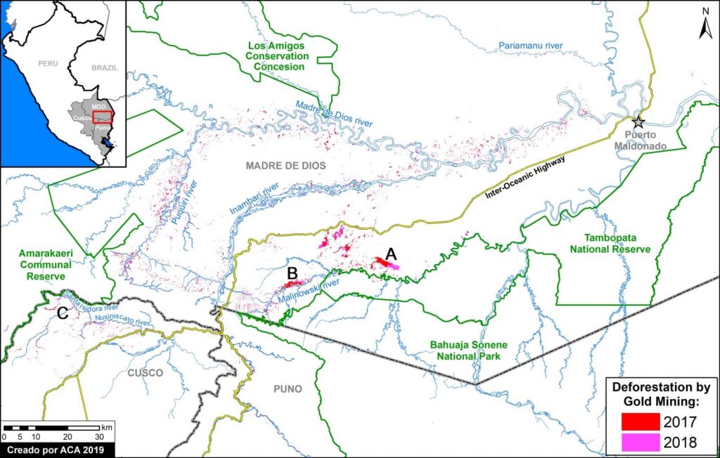
Annex 1 features a Reference Map of our full study area. The background is white to better indicate the mining deforestation areas. It also serves as a reference map with additional labels.

Reference Map. Gold mining deforestation in southern Peruvian Amazon. Data- MAAP, SERNANP

Annex 2: Land Use Map

Annex 2 features a Land Use Map with detailed data on mining concessions and other important land designations. The mining concession data comes from the web portal GEOCATMIN (Geological Information System and Mining Register), developed by INGEMMET (Geological Mining and Metallurgical Institute of Peru). We downloaded the data on January 2, 2019.

Land use Map. Data- INGEMMET, IBC, MINAGRI, SERNANP, Planet, UMD:GLAD, MINAM:PNCB

Methodology

We analyzed high-resolution satellite imagery (DigitalGlobe and Planet) for both 2017 and 2018 and digitized all new gold mining deforestation. Given the widespread mining across a large area, we also used automated forest loss alerts based on medium resolution Landsat imagery (PNCB/MINAM) to guide our analysis.

References

Centro de Innovación Científica Amazónica (CINCIA) (2018) Tres décadas de deforestación por minería aurífera en la Amazonía suroriental peruana. Resumen de Investigación No. 1.

Caballero Espejo et al. (2018) Deforestation and Forest Degradation Due to Gold Mining in the Peruvian Amazon: A 34-Year Perspective.  Remote Sens. 2018, 10 (12), 1903; https://doi.org/10.3390/rs10121903

Asner GP and Tupayachi R (2016) Environ. Res. Lett. 12 094004.

Planet Team (2017). Planet Application Program Interface: In Space for Life on Earth. San Francisco, CA. https://api.planet.com

Acknowledgements

We thank the following colleagues for helpful comments: Miles Silman (Wake Forest Univ), Sidney Novoa (ACCA), Ronald Catpo (ACCA), Efrain Samochuallpa (ACCA), Daniela Pogliani (ACCA), Alfredo Cóndor (ACCA), and Lorena Durand (ACCA).

Citation

Finer M, Mamani N (2018) Gold Mining Deforestation at Record High Levels in Southern Peruvian Amazon. MAAP: 96.

MAAP Synthesis #3: Deforestation in the Andean Amazon (Trends, Hotspots, Drivers)

Download a PDF of this Article
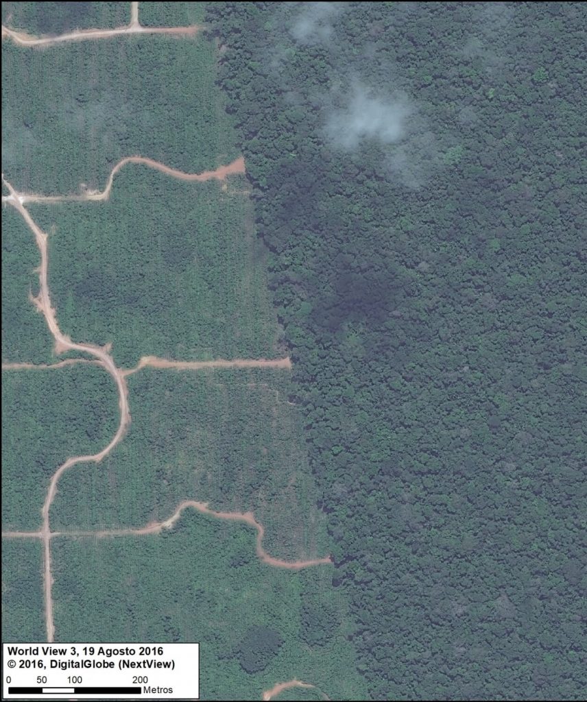
Satellite image of the deforestation produced by United Cacao. Source: DigitalGlobe (Nextview)

MAAP, an initiative of the organization Amazon Conservation, uses cutting-edge satellite technology to monitor deforestation in near real-time in the megadiverse Andean Amazon (Peru, Colombia, Ecuador, and Bolivia).

The monitoring is based on 5 satellite systems: Landsat (NASA/USGS), Sentinel (European Space Agency), PeruSAT-1, and the companies Planet and DigitalGlobe. For more information about our innovative methodology, see this recent paper in Science Magazine.

Launched in 2015, MAAP has published nearly 100 high-impact reports on the major Amazonian deforestation issues of the day.

Here, we present our third annual synthesis report with the objective to concisely describe the bigger picture: Deforestation trends, patterns, hotspots and drivers across the Andean Amazon.

Our principal findings include:

Trends: Deforestation across the Andean Amazon has reached 4.2 million hectares (10.4 million acres) since 2001. Annual deforestation has been increasing in recent years, with a peak in 2017 (426,000 hectares / 1,052,668 acres). Peru has had the highest annual deforestation, followed by surging Colombia (in fact, Colombia surpassed Peru in 2017). The vast majority of the deforestation events are small-scale (‹5 hectares / 12.35).

Hotspots: We present the first regional-scale deforestation hotspots map for the Andean Amazon, allowing for spatial comparisons between Peru, Colombia, and Ecuador.  We discuss six of the most important hotspots.

Drivers: We present MAAP Interactive, a dynamic map with detailed information on the major deforestation drivers: gold mining, agriculture (oil palm and cacao), cattle ranching, logging, and dams. Agriculture and ranching cause the most widespread impact across the region, while gold mining is most intense southern Peru.

Climate Change. We estimated the loss of 59 million metric tons of carbon in the Peruvian Amazon during the last five years (2013-17) due to forest loss. In contrast, we also show that protected areas and indigenous lands have safeguarded 3.17 billion metric tons of carbon.


I. Deforestation Trends

Image 1 shows forest loss trends in the Andean Amazon between 2001 and 2017.*  The left graph shows data by country, while the right graph shows data by forest loss event size.
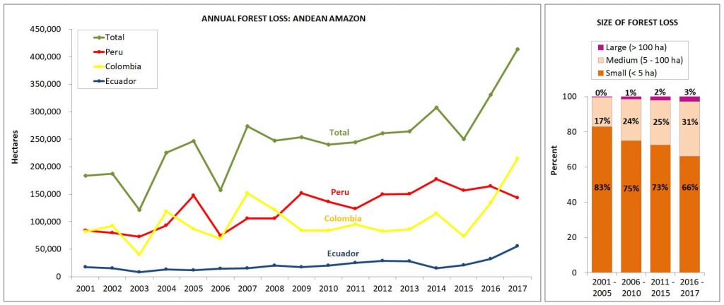
Image 1. Annual forest loss by country and size. Data: Hansen/UMD/Google/USGS/NASA, UMD/GLAD, Global Forest Watch, MINAM/PNCB, RAISG.

Trends by Country

Over the past 17 years (2001-2017), deforestation has surpassed 4.2 million hectares (10.4 million acres) in the Andean Amazon (see green line). Of this total, 50% is Peru (2.1 million hectares/5.2 million acres), 41% Colombia (1.7 million hectares/4.27 million acres), and 9% Ecuador (887,000 acres/359,000 hectares). This analysis did not include Bolivia.

Since 2007, there has been an increasing deforestation trend, peaking during the past two years (2016-17). In fact, 2017 has the highest annual forest loss on record with 426,000 hectares (over one million acres), more than double the total forest loss in 2006.

Peru had the highest average annual Amazonian deforestation between 2009 and 2016. The past four years have the highest annual deforestation totals on record in the country, with peaks in 2014 (177,566 hectares/439,000 acres) and 2016 (164,662 hectares/406,888 acres). According to new data from the Peruvian Environment Ministry, there was an important decline in 2017 (155,914 hectares/385,272 acres), but it is still the fourth highest annual total on record.

There has been a surge of deforestation in Colombia during the past two years. Note that in 2017, Colombia surpassed Peru with a record high of 214,700 hectares (530,400 acres) deforested.

Deforestation is also increasing in Ecuador, with highs of 32,000 hectares (79,000 acres) in 2016 and 55,500 hectares (137,000) acres in 2017.

For context, Brazil has had an average deforestation loss rate of 639,403 hectares (1.58 million acres) over the past several years.

* Data: Colombia & Ecuador: Hansen/UMD/Google/USGS/NASA; Peru: MINAM/PNCB, UMD/GLAD. While this information includes natural forest loss events, it serves as our best estimate of deforestation resulting from anthropogenic causes.  It is estimated that the non-anthropic loss comprises approximately 3.5% of the total loss. Note that the analysis does not include Bolivia.


Trends by Size

The pattern related to the size of deforestation events in the Andean Amazon remained relatively consistent over the last 17 years. Most noteworthy: the vast majority (74%) of the deforestation events are small-scale (‹5 hectares). Only 2% of deforestation events are large-scale (>100 hectares). The remaining 24% are medium-scale (5-100 hectares).

These results are important for conservation efforts.  Addressing this complex situation – in which most of the deforestation events are small-scale – requires significantly more attention and resources.  In addition, while large-scale deforestation (usually associated with agro-industrial practices) is not that common, it nonetheless represents a serious latent threat, due to the fact that only a small number of agro-industrial projects (for example, oil palm) are able to rapidly destroy thousands of acres of primary forest.


II. Deforestation Hotspots
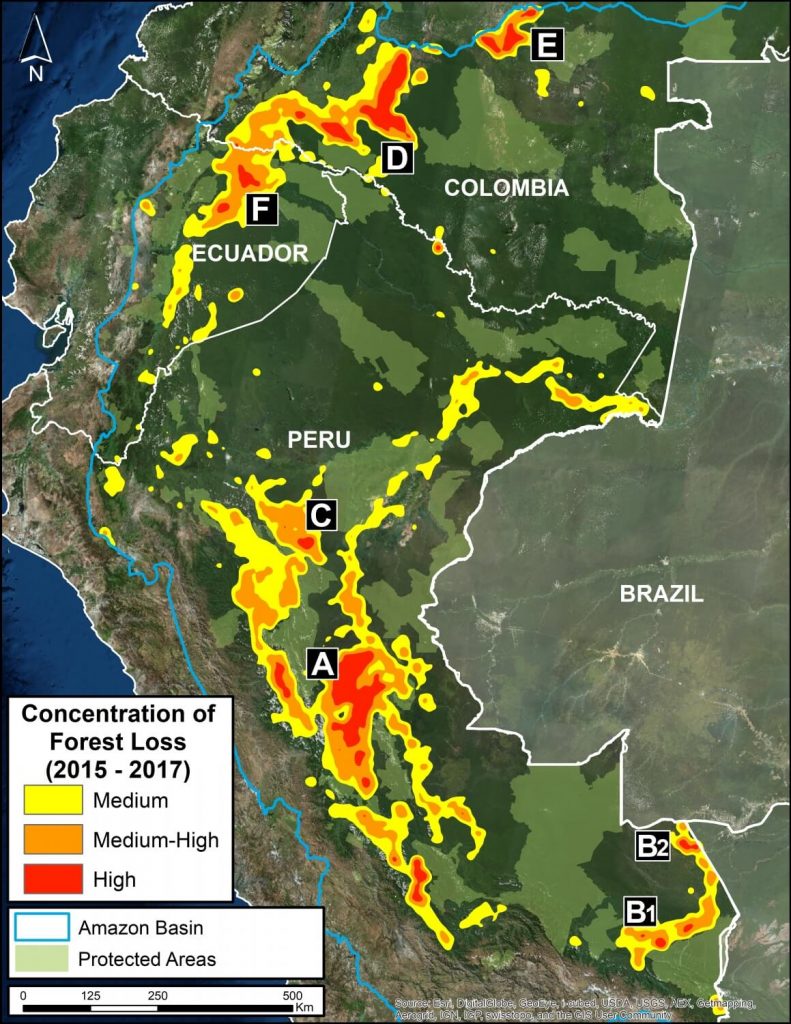
Image 2: Deforestation hotspots 2015-2017. Data: Hansen/UMD/Google/USGS/NASA.

We present the first regional-scale deforestation hotspots map across the Andean Amazon (Colombia, Ecuador, Peru).  Image 2 shows the results for the past three, 2015 – 2017.

The most critical zones (“high” deforestation density) are indicated in red. They include:

A. Central Peruvian Amazon: Over the last 10 years, this zone, located in the Ucayali and Huánuco regions, has consistently had one of the largest concentrations of deforestation in Peru (Inset A).  Its principal drivers include oil palm and cattle grazing.

B. Southern Peruvian Amazon: This zone, located in the Madre de Dios region, is impacted by gold mining (Inset B1), and increasingly by small- and medium-scale agriculture along the Interoceanic Highway (Inset B2).

C. Central Peruvian Amazon: A new oil palm plantation located in the San Martín region has been identified as a recent large-scale deforestation event in this zone (Inset C).

D. Southwestern Colombian Amazon: Cattle grazing is the principal deforestation driver documented in this zone, located in the departments of Caquetá and Putumayo (Inset D).

E. Northern Colombian Amazon: There is expanding deforestation along a new road in this zone, located in the department of Guaviare (Inset E).

F. Northern Ecuadoran Amazon: This zone is located in the Orellana province, where small- and medium-scale agriculture, including oil palm, is the principal driver of deforestation (Inset F).


III. Drivers of Deforestation     
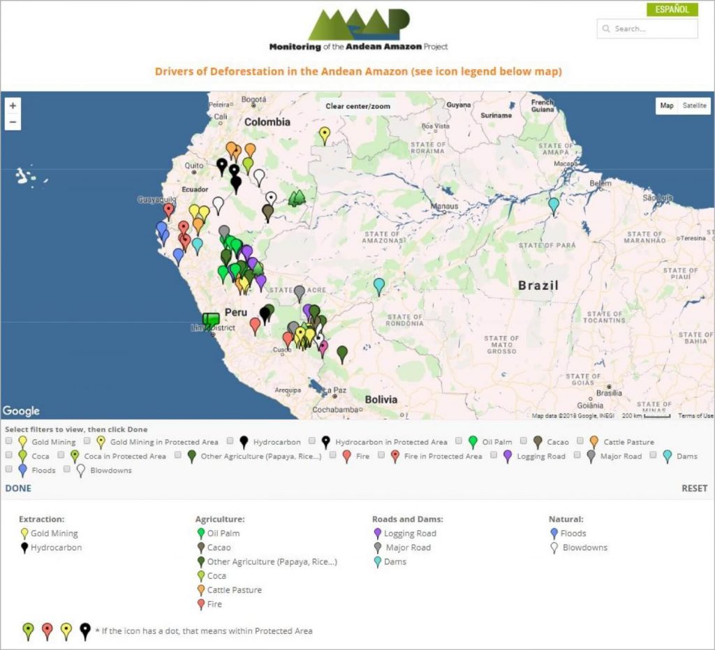
MAAP Interactive (screenshot)

One of the main objectives of MAAP is to improve the availability of precise and up-to-date information regarding the current drivers (causes) of deforestation in the Andean Amazon.  Indeed, one of our most important advances has been the use of high-resolution imagery to identify current deforestation drivers.

In order to improve the analysis and understanding of the identified drivers, we have created an Interactive Map that displays the spatial location of each driver associated with every MAAP report.  An important characteristic of this map is the ability to filter the data by driver, by selecting the boxes of interest.

Image 3 shows a screenshot of the Interactive Map.  Note that it contains detailed information on these principal drivers: gold mining, oil palm, cacao, small-scale agriculture, cattle pasture, logging roads, and dams.  It also includes natural causes such as floods, forest fires, and blowdowns.  In addition, it highlights deforestation events in protected areas.

Below, we discuss the principal drivers of deforestation and degradation in greater detail.


Agriculture  oil palm, cacao, and other crops

Image 4: Interactive Map, agriculture. Data: MAAP.

Image 4 shows the results of the interactive map when applying the agriculture-related filters.

Legend:

Oil palm (bright green)

Cacao (brown)

Other crops (dark green)

Agricultural activity is one of the principal causes of deforestation in the Andean Amazon.

The majority of agriculture-related deforestation is caused by small- and medium-scale plantations (‹50 hectares).

Deforestation for large-scale, agro-industrial plantations is much less common, but represents a critical latent threat.


Large-scale Agriculture

We have documented five major deforestation events produced by large-scale plantations since 2007:  four of these occurred in Peru (three of which are related to oil palm and one to cacao) and one in Bolivia (resulting from sugar cane plantations).

First, between 2007 and 2011, two large-scale oil palm plantations caused the deforestation of 7,000 hectares on the border between Loreto and San Martín (MAAP #16).  Subsequent plantations in the surrounding area caused the additional deforestation of 9,800 hectares.

It is important to note that the Peruvian company Grupo Palmas is now working towards a zero deforestation value chain and has a new sustainability policy (see Case C of MAAP #64).

Next, between 2012 and 2015, two other large-scale oil palm plantations deforested 12,000 hectares in Ucayali  (MAAP #4, MAAP #41).

Between 2013 and 2015, the company United Cacao deforested 2,380 hectares for cacao plantations in Loreto (MAAP #9, MAAP #13, MAAP #27, MAAP #35).

Deforestation from large-scale agriculture decreased in Peru between 2016 and 2017, but there was one notable event: an oil palm plantation of 740 hectares in San Martín (MAAP #78).

Another notable case of deforestation related to large-scale agriculture has been occurring in Bolivia, where a new sugarcane plantation has caused the deforestation of more than 2,500 hectares in the department of La Paz.

Additionally, we found three new zones in Peru characterized by the deforestation pattern produced by the construction of organized access roads which have the potential of becoming large-scale agriculture areas (MAAP #69).


Small and Medium-scale Agriculture

Deforestation caused by small- and medium-scale agriculture is much more widespread, but it is often difficult to identify the driver from satellite imagery.

We have identified some specific cases of oil palm in Huánuco, Ucayali, Loreto, and San Martín (MAAP #48, MAAP #26, MAAP #16).

Cacao and papaya are emerging drivers in Madre de Dios.  We have documented cacao deforestation along the Las Piedras River (MAAP #23, MAAP #40) and papaya along the Interoceanic Highway (MAAP #42).

Corn and rice cultivation appear to be turning the area around the town of Iberia into a deforestation hotspot (MAAP #28).  In other cases, we have documented deforestation resulting from small- and medium-scale agriculture, though it has not been possible to identify the type of crop (MAAP #75, MAAP #78).

Additionally, small-scale agriculture is possibly a determining factor in the forest fires that degrade the Amazon during the dry season (MAAP #45, MAAP #47).

The cultivation of illicit coca is a cause of deforestation in some areas of Peru and Colombia.  For example, in southern Peru, the cultivation of coca is generating deforestation within the Bahuaja Sonene National Park and its surrounding areas.


Cattle Ranching
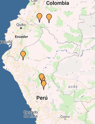
Image 5: Interactive Map, cattle ranching. Data: MAAP.

By analyzing high-resolution satellite imagery, we have developed a methodology for identifying areas deforested by cattle ranching.*

Image 5 shows the results of the Interactive Map when applying the “Cattle pasture” filter, indicating the documented examples in Peru and Colombia.

Legend:
Cattle ranching (orange)

Cattle ranching is the principal driver of deforestation in the central Peruvian Amazon (MAAP #26, MAAP #37, MAAP #45, MAAP #78). We also identified recent deforestation from cattle ranching in northeastern Peru (MAAP #78).

In the Colombian Amazon, cattle ranching is one the primary direct drivers in the country’s most intense deforestation hotspots (MAAP #63, MAAP #77).

* Immediately following a major deforestation event, the landscape of felled trees is similar for both agriculture and cattle pasture.  However, by studying an archive of images and going back in time to analyze older deforestation cases, it is possible to distinguish between the drivers.  For example, after one or two years, agriculture and cattle pasture appear very different in the images. The former tends to have organized rows of new plantings, while the latter is mostly grassland.


Gold Mining
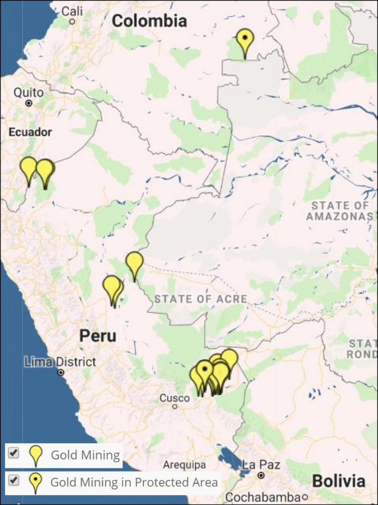
Image 6: Interactive Map, gold mining. Data: MAAP.

Image 6 shows the results of the Interactive Map when applying the “Gold mining” filter.

Legend:
Gold Mining (yellow)

*With dot indicates within protected area

The area that has been most impacted by gold mining is clearly the southern Peruvian Amazon, where we estimate the total deforestation of more than 63,800 hectares. Of this, at least 7,000 hectares have been lost since 2013.  The two most critical zones are La Pampa and Alto Malinowski in Madre de Dios (MAAP #87, MAAP #75, MAAP #79).  Another critical area exists in Cusco in the buffer zone of the Amarakaeri Communal Reserve, where mining deforestation is now less than one kilometer from the boundary of the protected area (MAAP #71).

It is important to highlight two important cases in which the Peruvian government has taken effective actions to halt illegal mining within protected areas (MAAP #64).  In September 2015, illegal miners invaded Tambopata National Reserve and deforested 550 hectares over the course of a two-year period.  At the end of 2016, the government intensified its interventions and the invasion was halted in 2017. In regards to Amarakaeri Communal Reserve, in June 2015 we revealed the mining invasion deforestation of 11 hectares.  Over the course of the following weeks, SERNANP and ECA Amarakaeri implemented measures and rapidly halted the illegal activity.

Other small gold-mining fronts are emerging in the northern and central Peruvian Amazon (MAAP #45, MAAP #49).

In addition, we have also documented deforestation linked to illegal gold-mining activities in the Puinawai National Park in the Colombian Amazon.


Logging
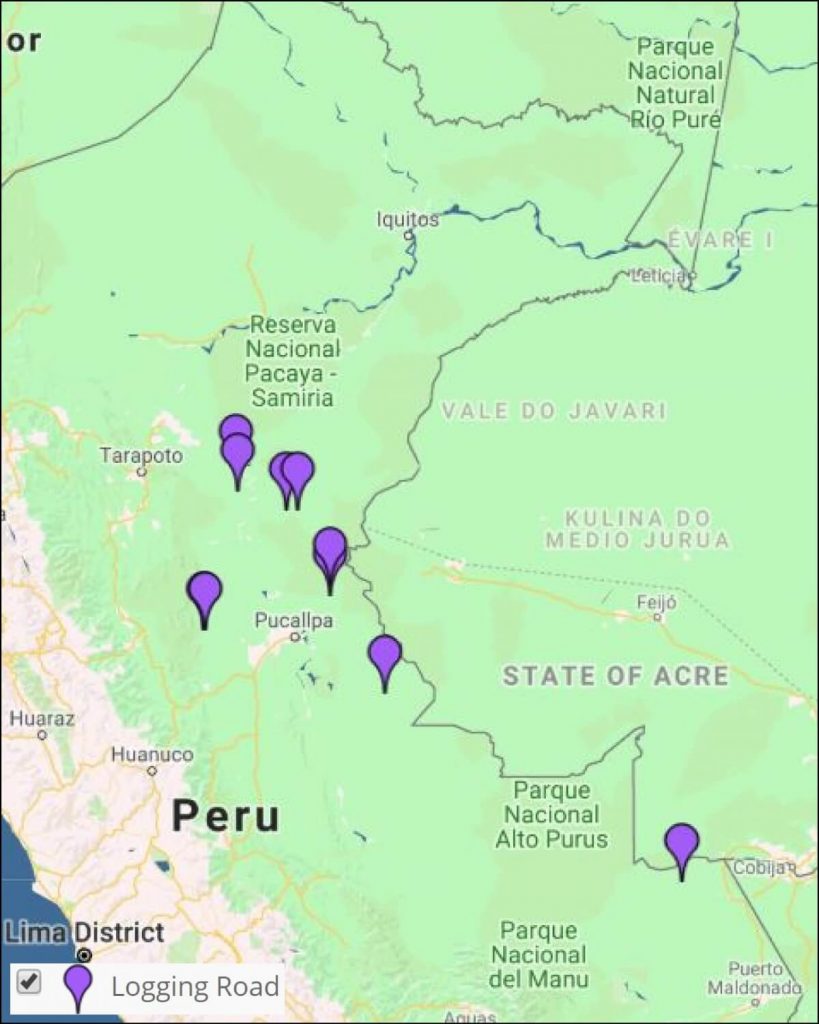
Image 7: Interactive Map, logging roads. Data: MAAP.

In MAAP #85 we proposed a new tool to address illegal logging in the Peruvian Amazon: utilize satellite imagery to monitor construction of logging roads in near real-time.

Image 7 shows the results of the Interactive Map when applying the “Logging roads” filter.

Legend:
Logging Road (purple)

We estimate that 2,200 kilometers of forest roads have been constructed in the Peruvian Amazon during the last three years (2015-2017).  The roads are concentrated in southern Loreto, Ucayali, and northwestern Madre de Dios.


Roads
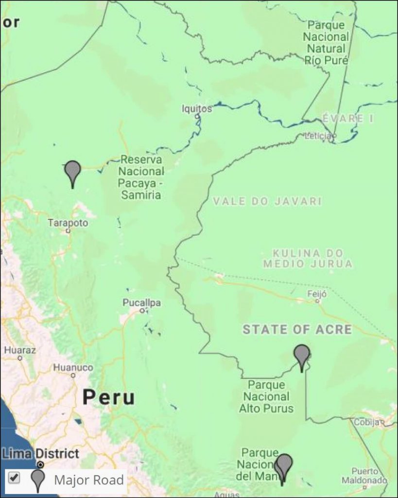
Image 8: Interactive map, roads. Data: MAAP.

It has been well-documented that roads are one of the most important drivers of deforestation in the Amazon, particularly due to the fact that they facilitate human access and activities related to agriculture, cattle ranching, mining, and logging.

Image 8 shows the results of the Interactive Map when applying the “Roads” filter.

Legend:
Road (gray)

We have analyzed two controversial proposed roads in Madre de Dios, Peru.

The Nuevo Edén – Boca Manu – Boca Colorado road would traverse the buffer zone of two protected areas: Amarakaeri Communal Reserve and Manu National Park (MAAP #29).

The other, the Puerto Esperanza-Iñapari road, would traverse the Purús National Park and threaten the territory of the indigenous peoples in voluntary isolation who live in this remote area (MAAP #76).


Hydroelectric dams

Image 9 shows the results of the Interactive Map when applying the “Dams” filter.

Legend:
Hydroelectric Dam (light blue)
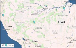
To date, we have analyzed three hydroelectric dams located in Brazil.  We have documented the loss of 36,100 hectares of forest associated with flooding produced by two dams (San Antonio and Jirau) on the Madeira River near the border with Bolivia (MAAP #34).  We also analyzed the controversial Belo Monte hydroelectrical complex located on the Xingú River, and estimate that 19,880 hectares of land have been flooded. According to the imagery, this land is a combination of forested areas and agricultural areas (MAAP #66).

Additionally, we show a very high-resolution image of the exact location of the proposed Chadín-2 hydroelectric dam on the Marañón River in Peru (MAAP #80).


Hydrocarbon (oil and gas)
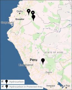
Image 10: Interactive map, hidrocarbon. Data: MAAP.

Image 10 shows the results of the Interactive Map when applying the “Hydrocarbon filter.

Legend:
Hydrocarbon (black)

Our first report on this sector focused on Yasuní National Park in the Ecuadorian Amazon.  We documented the direct and indirect deforestation amounts of 417 hectares (MAAP #82).

We also show the location of recent deforestation in two hydrocarbon block in Peru: Block 67 in the north and Blocks 57 in the south.


Climate Change

Tropical forests, especially the Amazon, sequester huge amounts of carbon, one of the main greenhouse gases driving climate change.

In MAAP #81, we estimated the loss of 59 million metric tons of carbon in the Peruvian Amazon during the last five years (2013-17) due to forest loss, especially deforestation from mining and agricultural activities. This finding reveals that forest loss represents nearly half (47%) of Peru’s annual carbon emissions, including from burning fossil fuels.

In contrast, in MAAP #83 we show that protected areas and indigenous lands have safeguarded 3.17 billion metric tons of carbon, as of 2017. That is the equivalent to 2.5 years of carbon emissions from the United States.

The breakdown of results are:

1.85 billion tons safeguarded in the Peruvian national protected areas system;

1.15 billion tons safeguarded in titled native community lands; and

309.7 million tons safeguarded in Territorial Reserves for indigenous peoples in voluntary isolation.


Citation

Finer M, Mamani N (2018) Deforestation in the Andean Amazon (Trends, Hotspots, Drivers). MAAP Synthesis #3.
MAAP #91: Introducing Perusat-1, Peru’s New High-Resolution Satellite

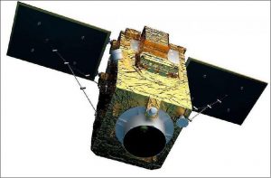
In September 2016, Peru’s first satellite, PeruSAT-1, launched. It is Latin America’s most powerful Earth observation satellite, capturing images at a resolution of 0.70 meters.
PeruSat-1. Credit: Airbus DS

The cutting-edge satellite was constructed by Airbus (France) and is now operated by the Peruvian Space Agency, CONIDA.

The organization Amazon Conservation was granted early access to the imagery to boost efforts related to near real-time deforestation monitoring.

Below, we present a series of PeruSAT images that demonstrate their powerful utility in terms of detecting and understanding deforestation in the Peruvian Amazon.

Maap #90: Using Drones To Monitor Deforestation And Illegal Logging

Drone types- helicopter and fixed-wing (plane)

For the past three years, the organization Amazon Conservation has been working to establish a sustainable, local-based drones program for environmental monitoring in the southern Peruvian Amazon (Madre de Dios region).

This program is based on two types of drones, multi-rotor (helicopter style) and fixed-wing (airplane style).

One of the main objectives is to improve the near real-time monitoring of deforestation and illegal logging.

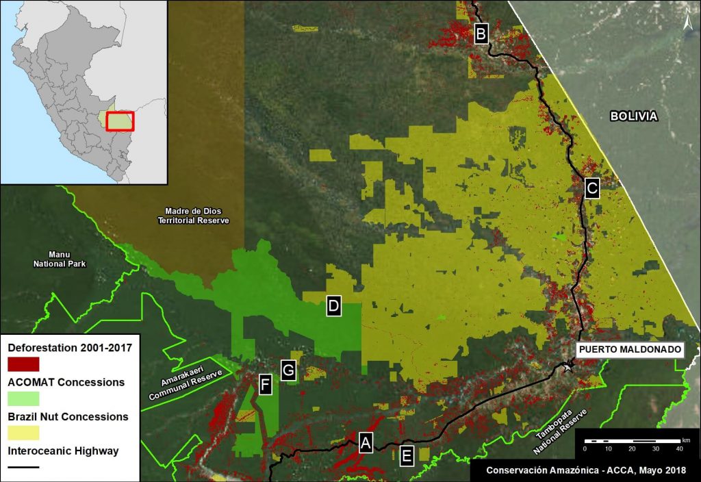
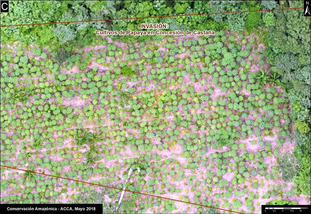
The monitoring is currently focused on three priority areas: 1) Brazil nut concessions, 2) forestry concessions of the local association ACOMAT, and 3) along the Interoceanic Highway (see Base Map).

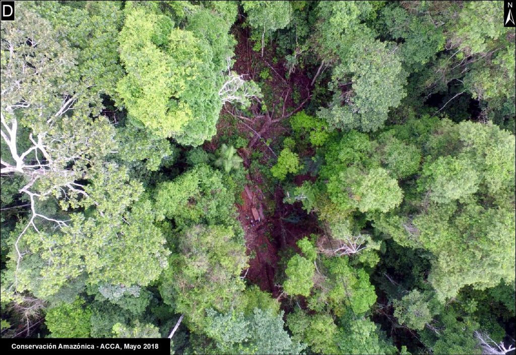
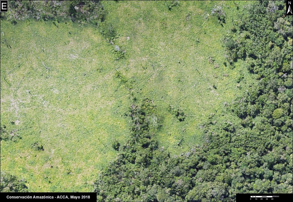
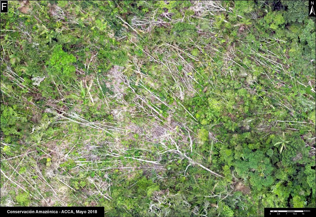
Below, we show a series of drone images that we have used to identify the drivers of recent deforestation events. These drivers include gold mining, agriculture, illegal logging, cattle pasture, and natural forest loss.

Base Map. Priority areas of the Amazon Conservation drones initiative.

Interoceanic Highway

In March 2018, in collaboration with the organization ProPurús, we realized drone flights along the Interoceanic Highway in an effort to demonstrate the possible threats of building a new road along the border with Brazil (see MAAP #76). The following images show the two main threats to the area: gold mining and small/medium-scale agriculture (<50 hectares).

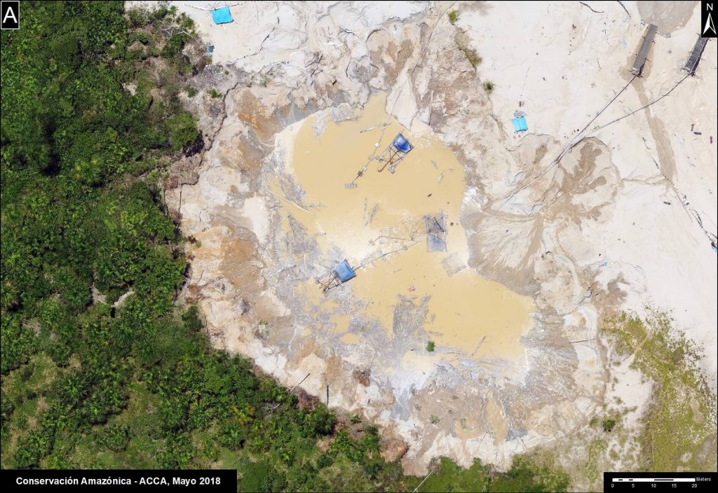
Image A. Drone image- gold mining.
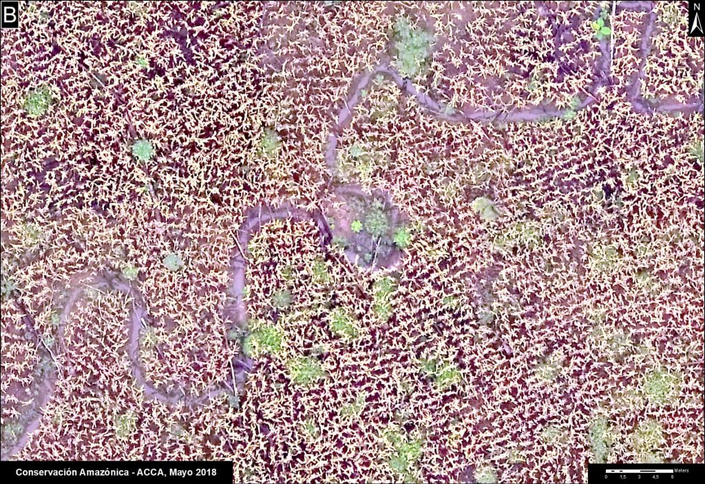
B. Drone image- Deforestation from agriculture (corn)

Brazil Nut Concessions

In 2018, Amazon Conservation launched a new project, funded by Google Challenge, to develop a monitoring program for Brazil nut concessions covering a million hectares (2.47 million acres) in southern Peru. For example, the following image shows the invasion of a papaya plantation that caused the recent deforestation of five acres inside a concession.

C. Drone image- Invasion of papaya in Brazil nut concession.

ACOMAT Forestry Concessions

Since 2017, Amazon Conservation has been working on a project, financed by the Norwegian Agency for Development Cooperation (NORAD), to improve the monitoring of forest concessions of the local association ACOMAT (Association of Timber and Non-Timber Forest Concessionaires of the Provinces from Manu and Tambopata). The following images show examples of forest loss and degradation due to illegal logging, cattle grazing, natural loss (windstorm), and gold mining.

D. Drone image- illegal logging.
E. Drone image- cattle pasture.
F. Drone image- natural forest loss from windstorm.
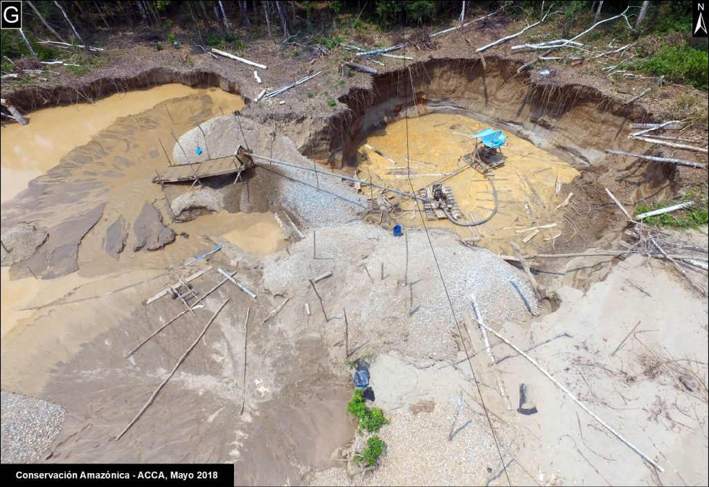
G. Drone image- gold mining.

Citation

Garcia R, Novoa S, Castañeda C, Rengifo P, Jimenez M, Finer M (2018) Using Drones to monitor Deforestation and Illegal Logging. MAAP: 90.