MAAP #132: Amazon Deforestation Hotspots 2020

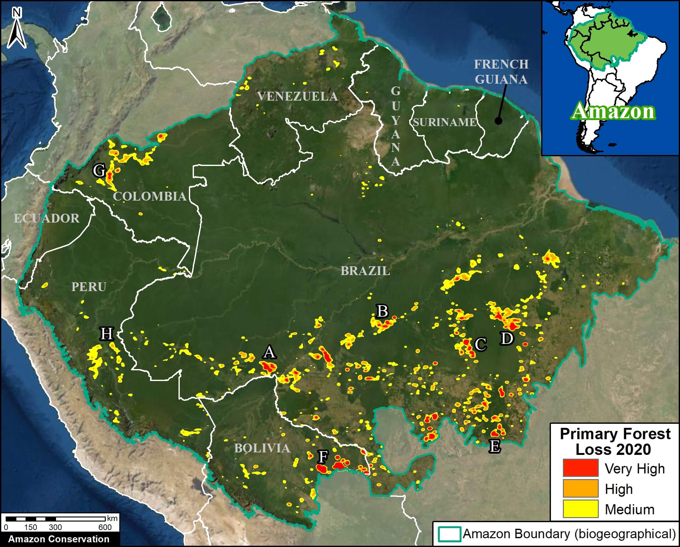
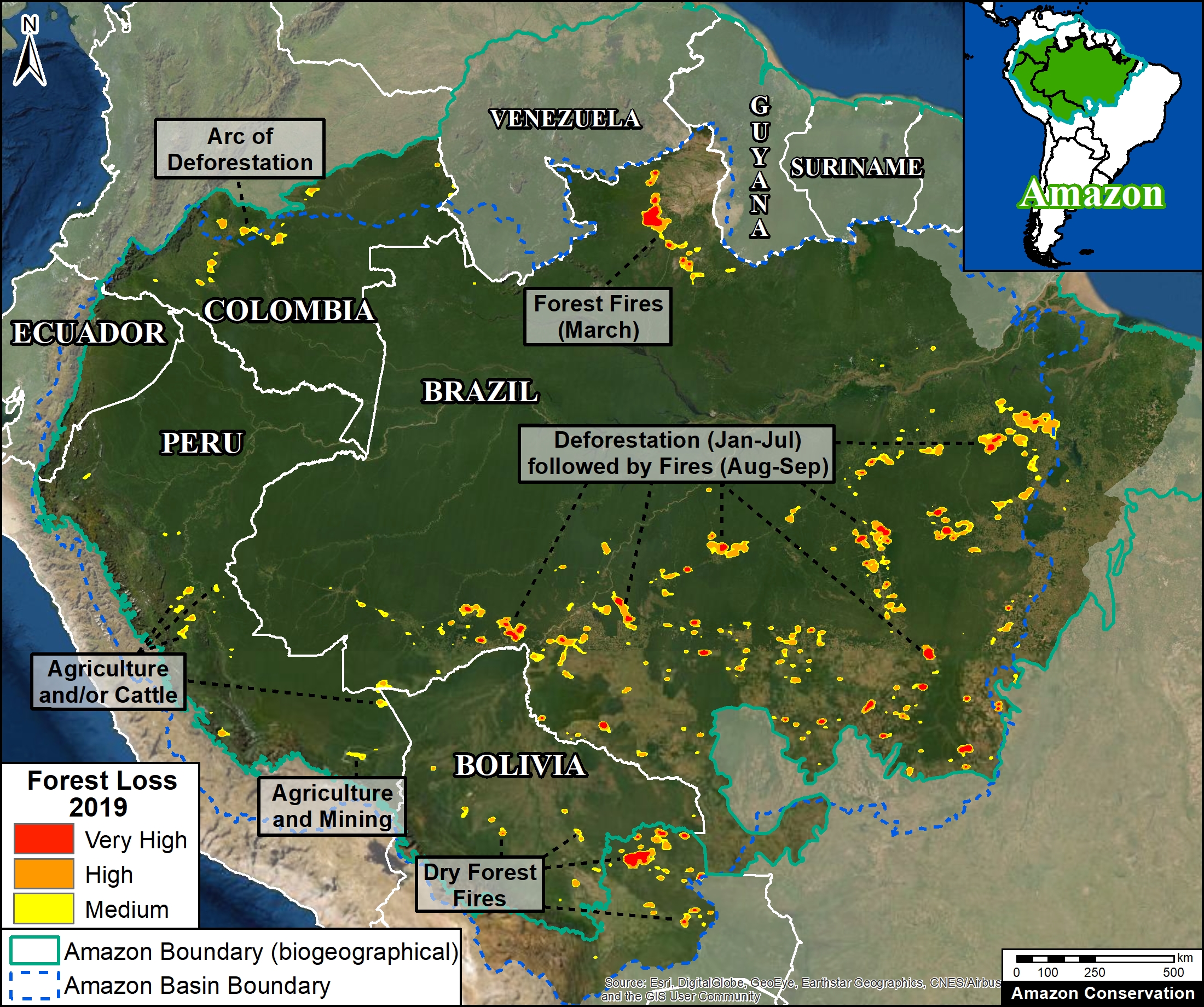
We present a first look at the major hotspots of primary forest loss across the Amazon in 2020 (see Base Map).*

Base Map. Forest loss hotspots across the Amazon in 2020. Data: UMD/GLAD, RAISG, MAAP. The letters A-G correspond to the zoom examples below.

There are several major headlines:

  • We estimate over 2 million hectares (5 million acres) of primary forest loss across the nine countries of the Amazon in 2020.*
  • The countries with the highest 2020 primary forest loss are 1) Brazil, 2) Bolivia, 3) Peru, 4) Colombia, 5) Venezuela, and 6) Ecuador.
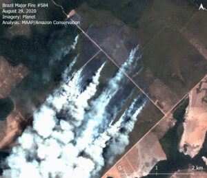
  • The majority of the hotspots occurred in the Brazilian Amazon, where massive deforestation stretched across nearly the entire southern region. Many of these areas were cleared in the first half of the year and then burned in July and August. In September, there was a shift to actual forest fires (see MAAP #129).
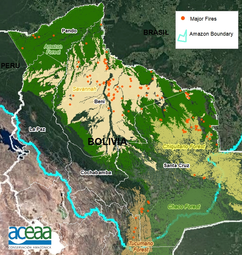
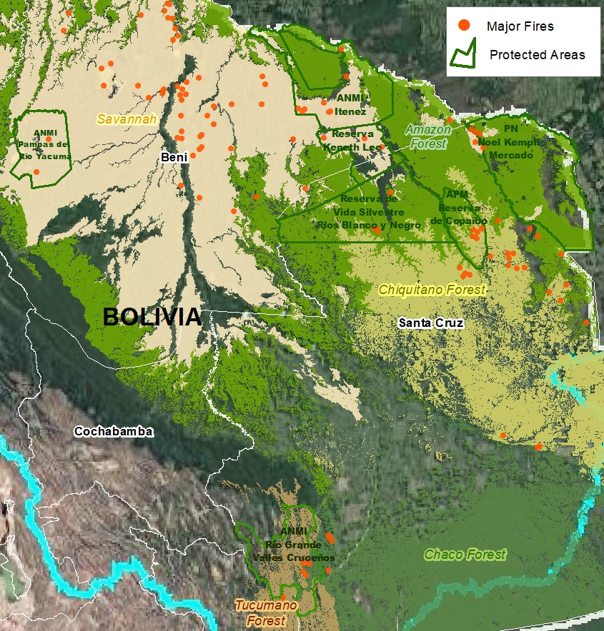
  • Several of the most intense hotspots were in the Bolivian Amazon, where fires raged through the dry forests (known as the Chiquitano) in the southeast region.
  • There continues to be an arc of deforestation in the northwestern Colombian Amazon, impacting numerous protected areas.
  • In the Peruvian Amazon, deforestation continues to impact the central region. On the positive, the illegal gold mining that plagued the southern region has decreased thanks to effective government action (see MAAP #130).

Below, we show a striking series of high-resolution satellite images that illustrate some of the major deforestation events across the Amazon in 2020 (indicated A-G on the Base Map).


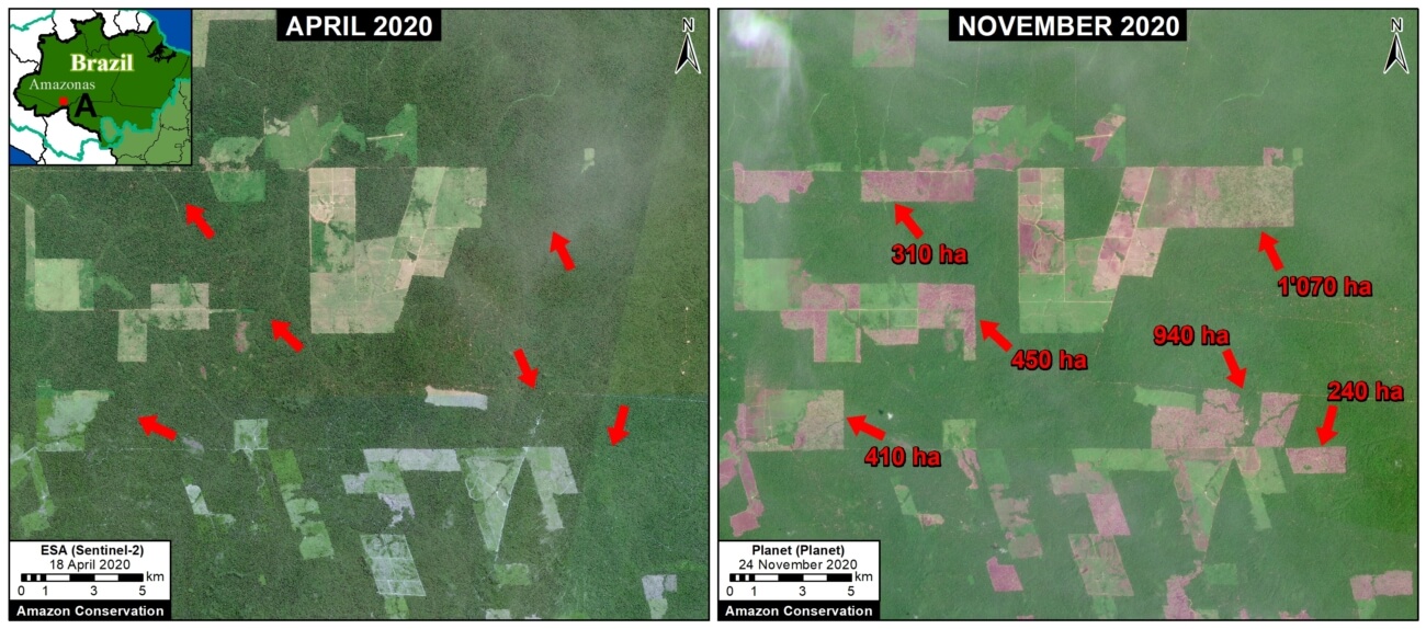
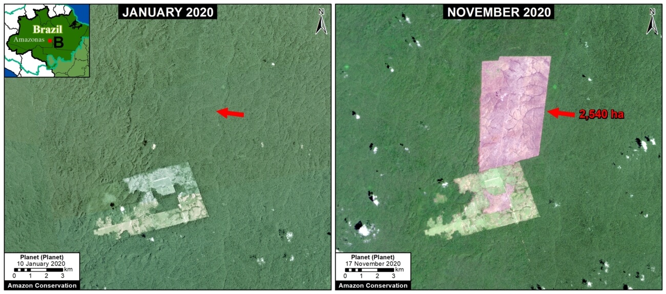
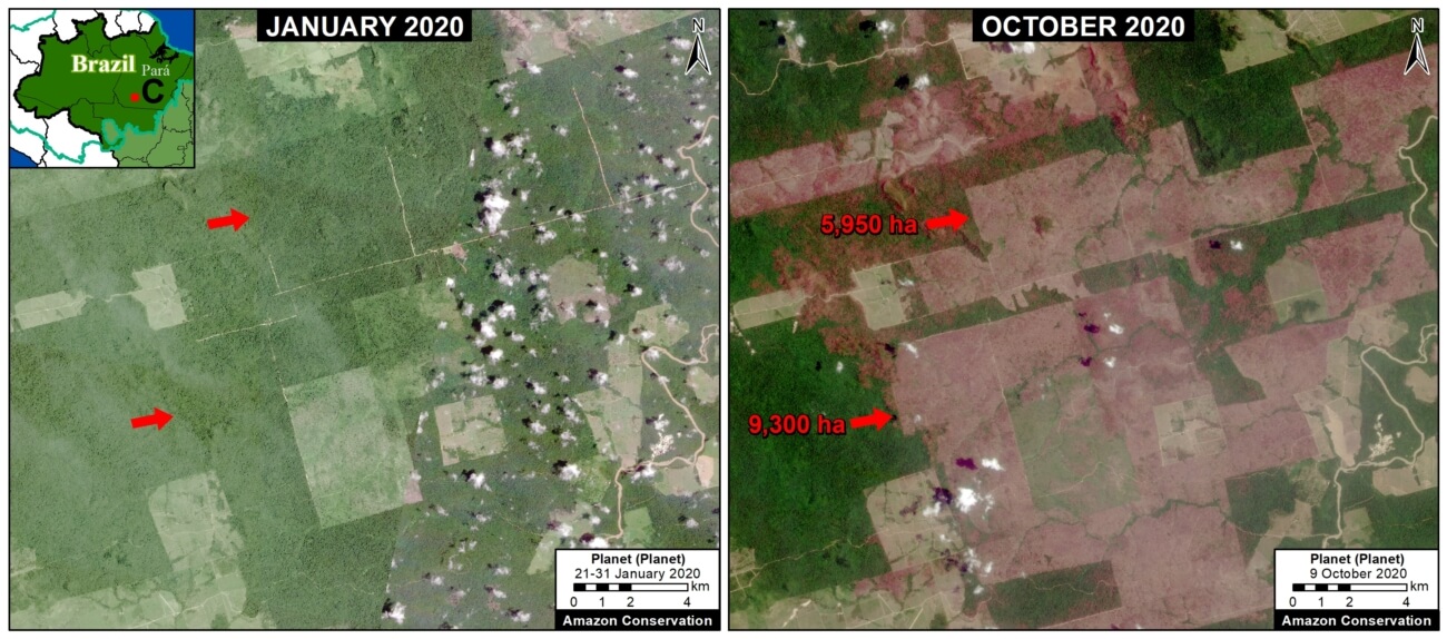
Widespread Deforestation in the Brazilian Amazon

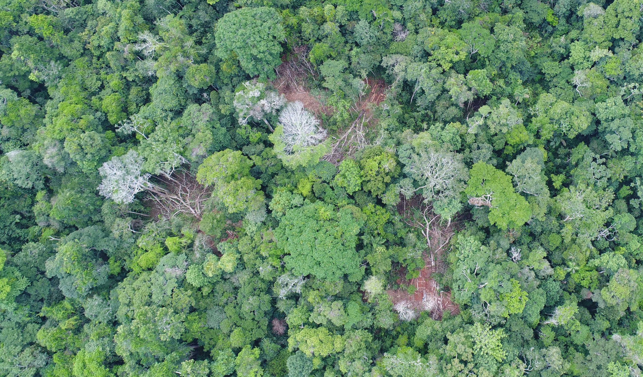
Zooms A-C show examples of a troublingly common phenomenon in the Brazilian Amazon: large-scale deforestation events in the first half of the year that are later burned in July and August, causing major fires due to the abundant recently-cut biomass. Much of the deforestation in these areas appears to associated with clearing rainforests for cattle pastures. The three examples below show the striking loss of over 21,000 hectares of primary forest in 2020.

Zoom A. Deforestation in the Brazilian Amazon (Amazonas state) of 3,400 hectares between April (left panel) and November (right panel) 2020. Data: ESA, Planet.


Zoom B. Deforestation in Brazilian Amazon (Amazonas state) of 2,540 hectares between January (left panel) and November (right panel) 2020. Data: Planet.


Zoom C. Deforestation in Brazilian Amazon (Para state) of 15,250 hectares between January (left panel) and October (right panel) 2020. Data: Planet.


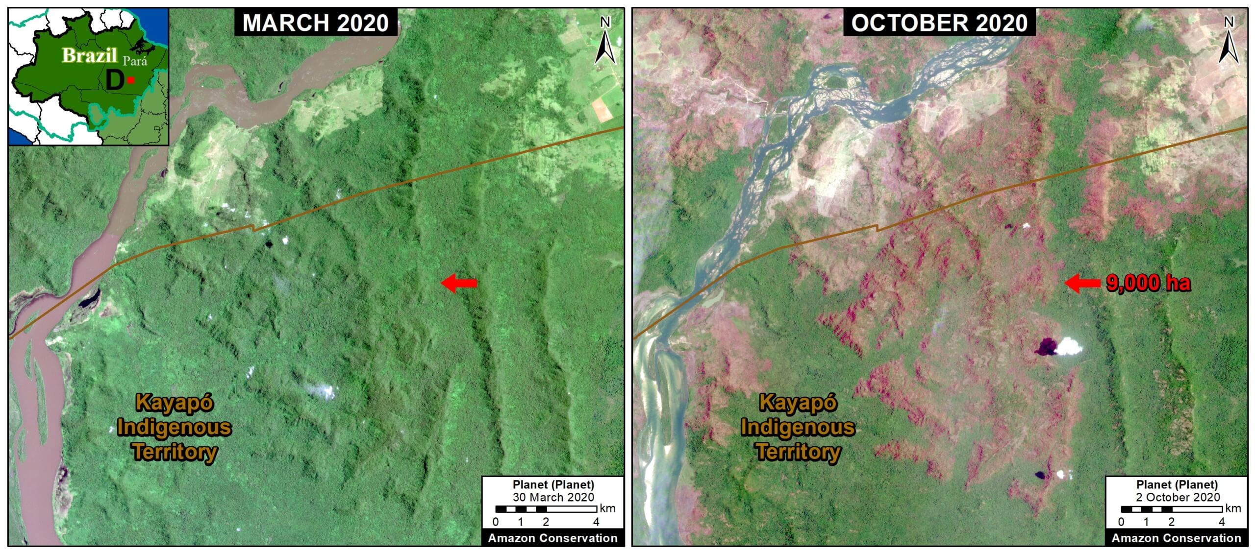
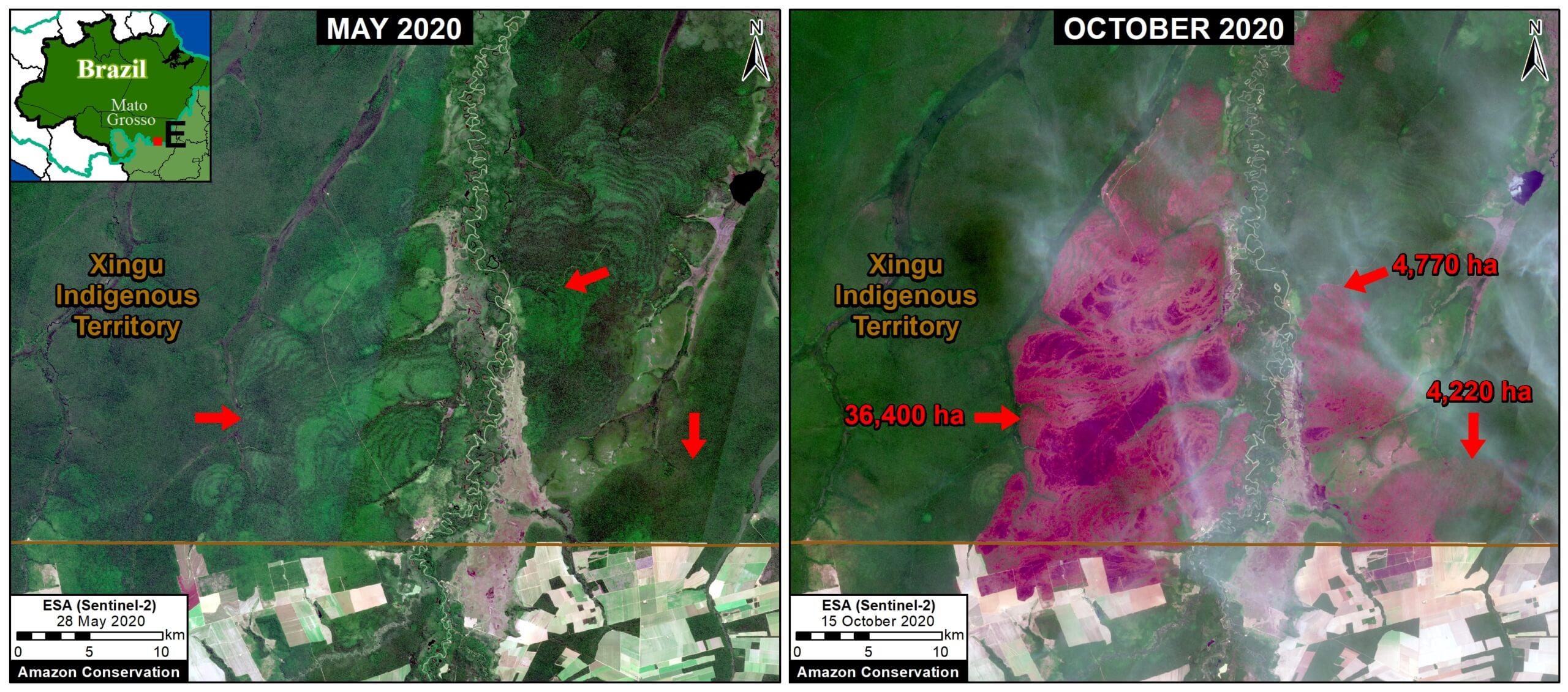
Forest Fires in the Brazilian Amazon

In September, there was a shift to actual forest fires in the Brazilian Amazon (see MAAP #129). Zoom D and E show examples of these major forest fires, which burned over 50,000 hectares in the states of Pará and Mato Grosso. Note both fires impacted indigenous territories (Kayapo and Xingu, respectively).

Zoom D. Forest fire in Brazilian Amazon (Para state) that burned 9,000 hectares between March (left panel) and October (right panel) 2020. Data: Planet.
Zoom E. Forest fire in Brazilian Amazon (Mato Grosso state) that burned over 44,000 hectares between May (left panel) and October (right panel) 2020. Data: Planet.

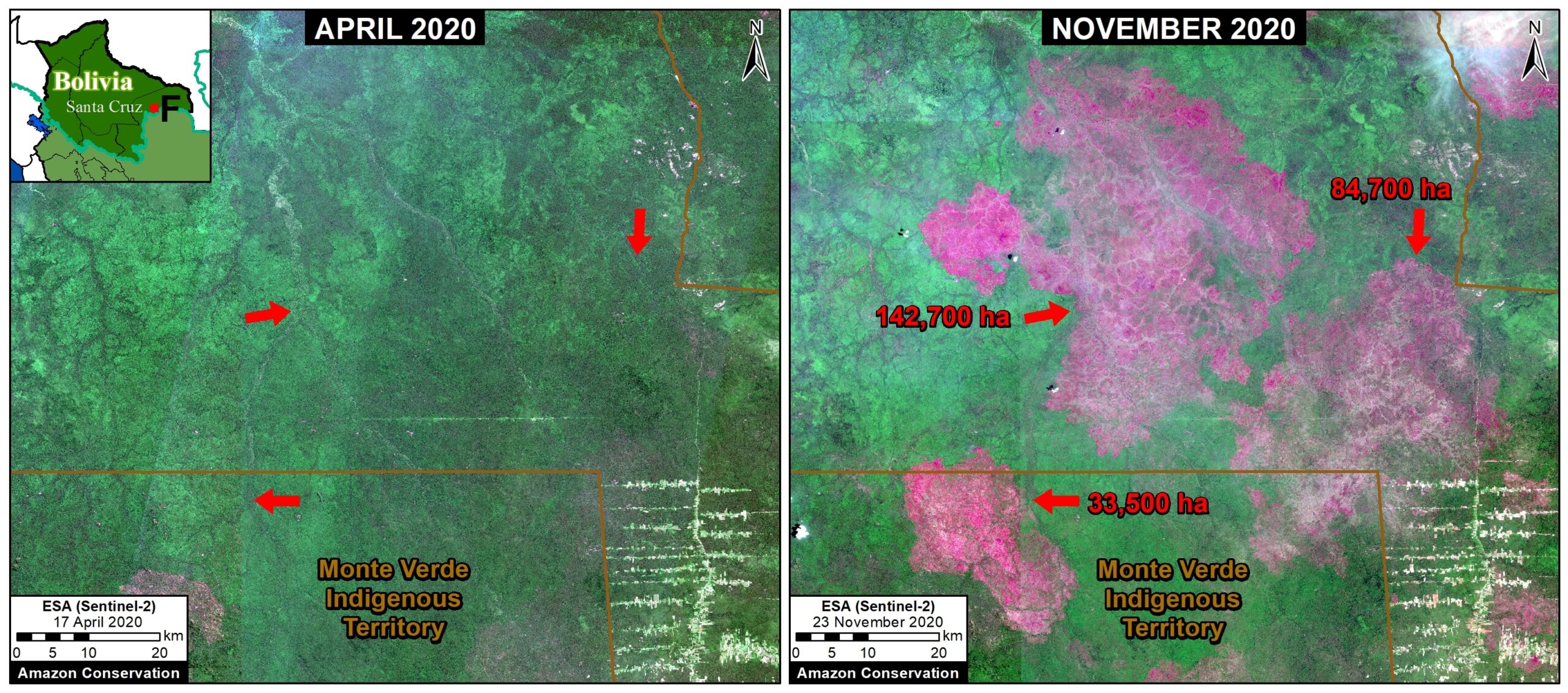
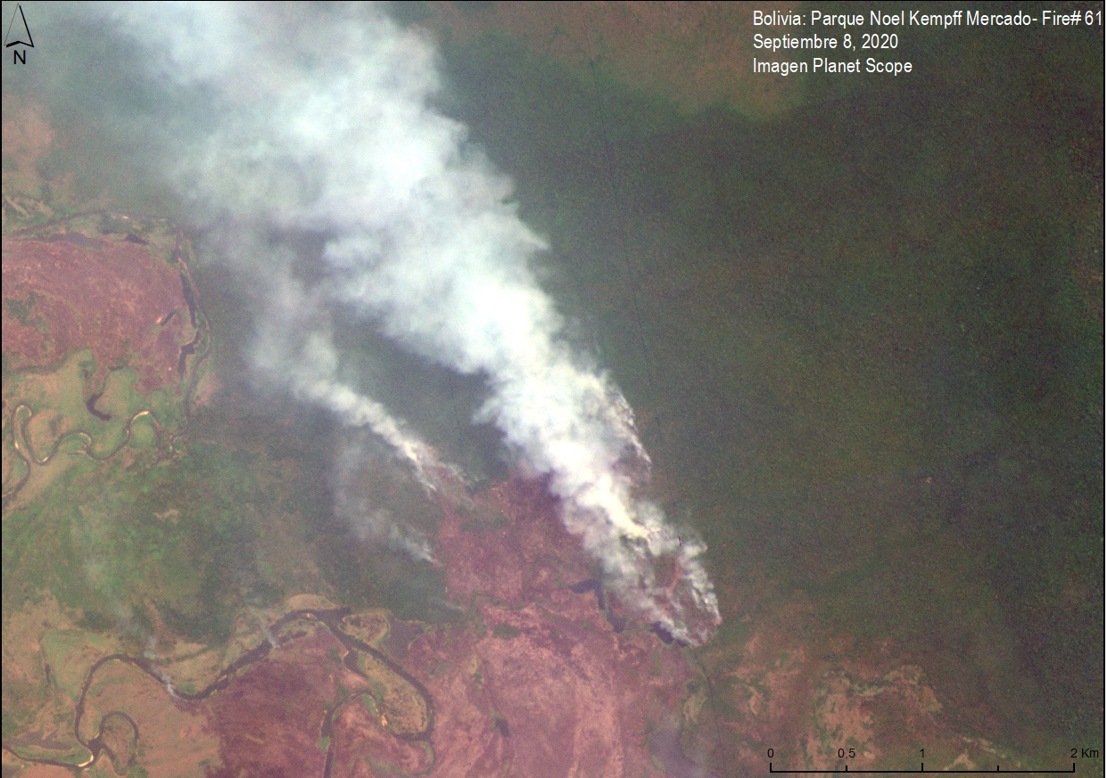
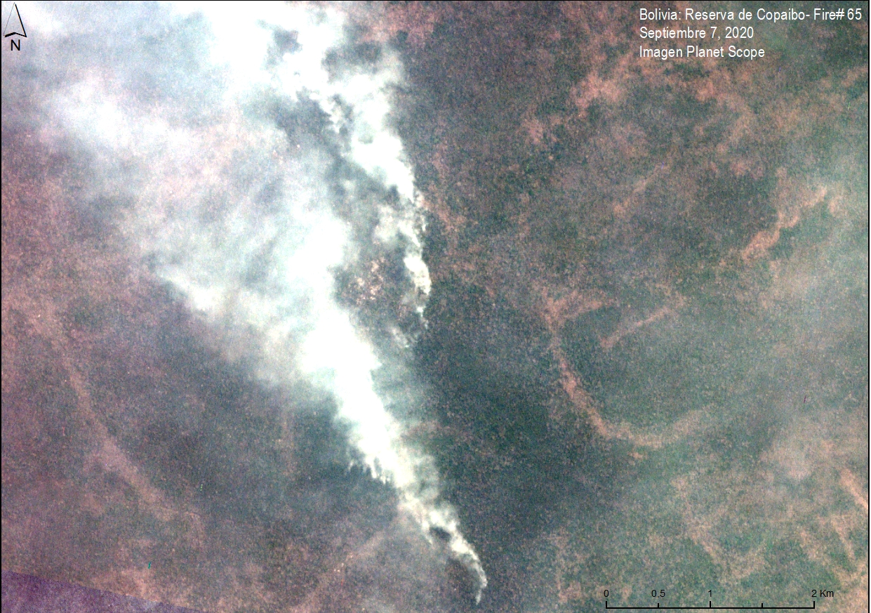
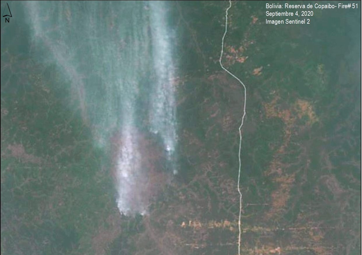
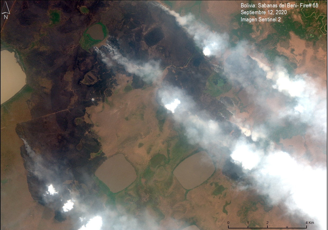
Forest Fires in the Bolivian Amazon

The Bolivian Amazon also experienced another intense fire season in 2020. Zoom F shows the burning of a massive area (over 260,000 hectares) in the Chiquitano dry forests (Santa Cruz department).

Zoom F. Forest fire in Bolivian Amazon (Santa Cruz) that burned over 260,000 hectares between April (left panel) and November (right panel) 2020. Data: ESA.

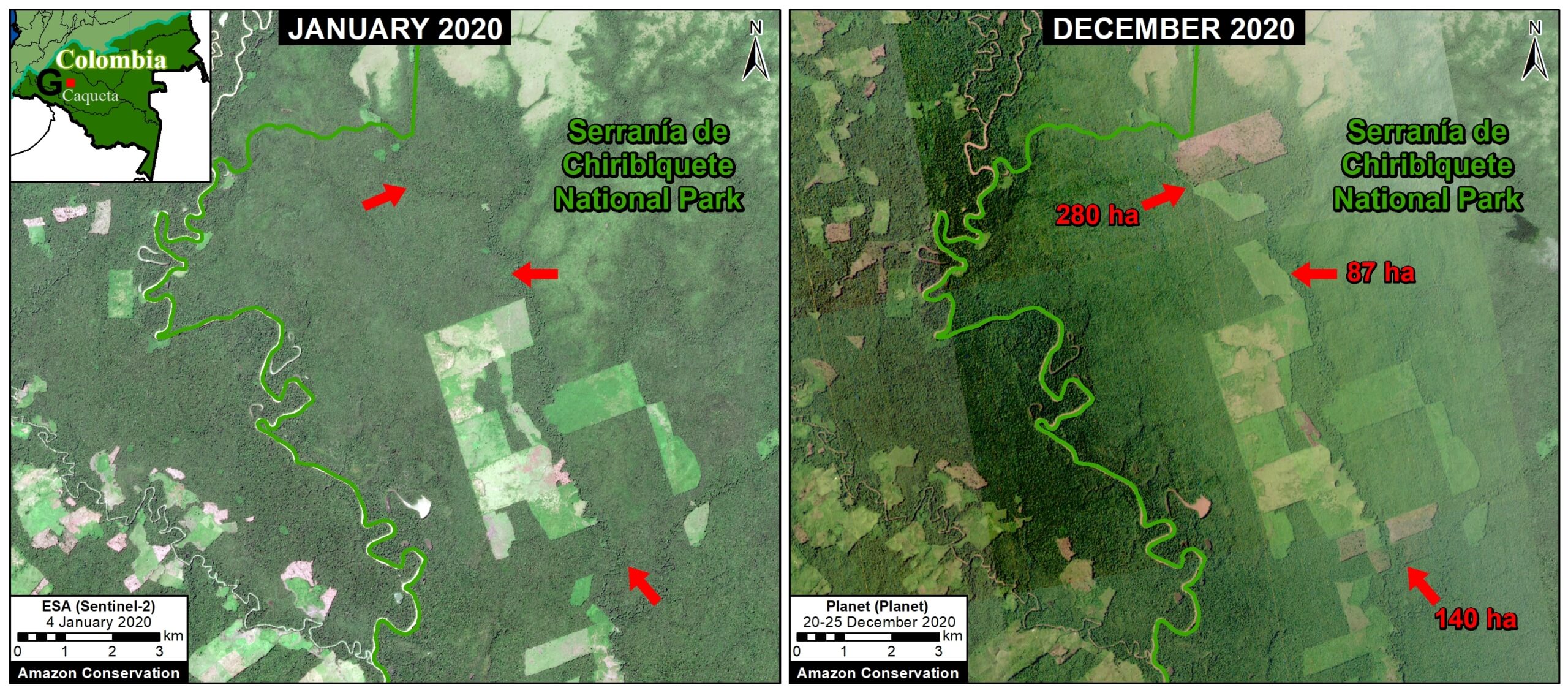
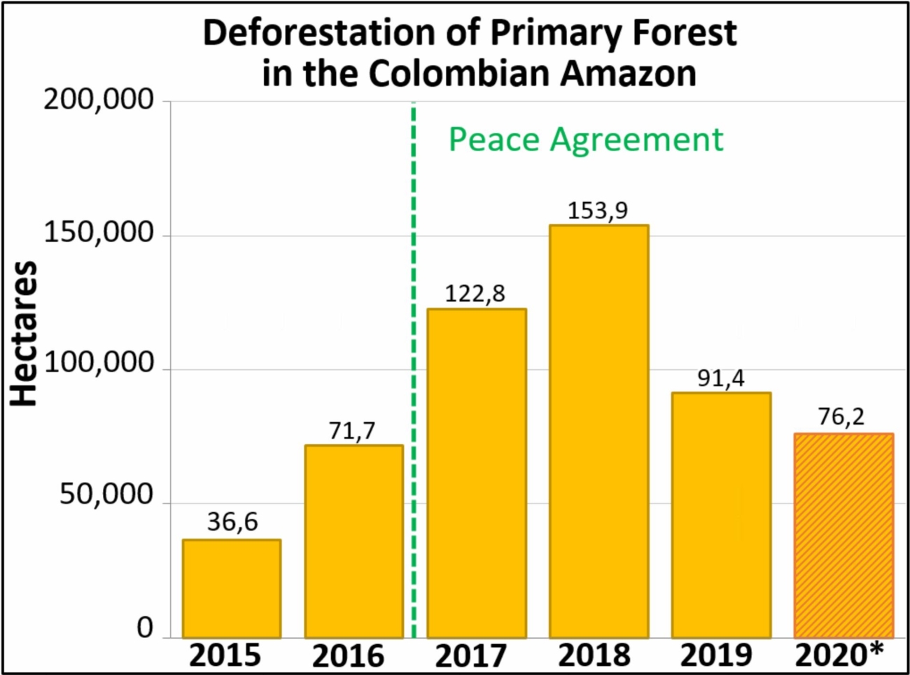
Arc of Deforestation in the Colombian Amazon

As described in previous reports (see MAAP #120), there is an “arc of deforestation” concentrated in the northwest Colombian Amazon. This arc impacts numerous protected areas (including national parks) and Indigenous Reserves. For example, Zoom G shows the recent deforestation of over 500 hectares in Chiribiquete National Park. Similar deforestation in that sector of the park appears to be conversion to cattle pasture.

Zoom G. Deforestation in Colombian Amazon of over 500 hectares in Chiribiqete National Park between January (left panel) and December (right panel) 2020. Data: ESA, Planet.

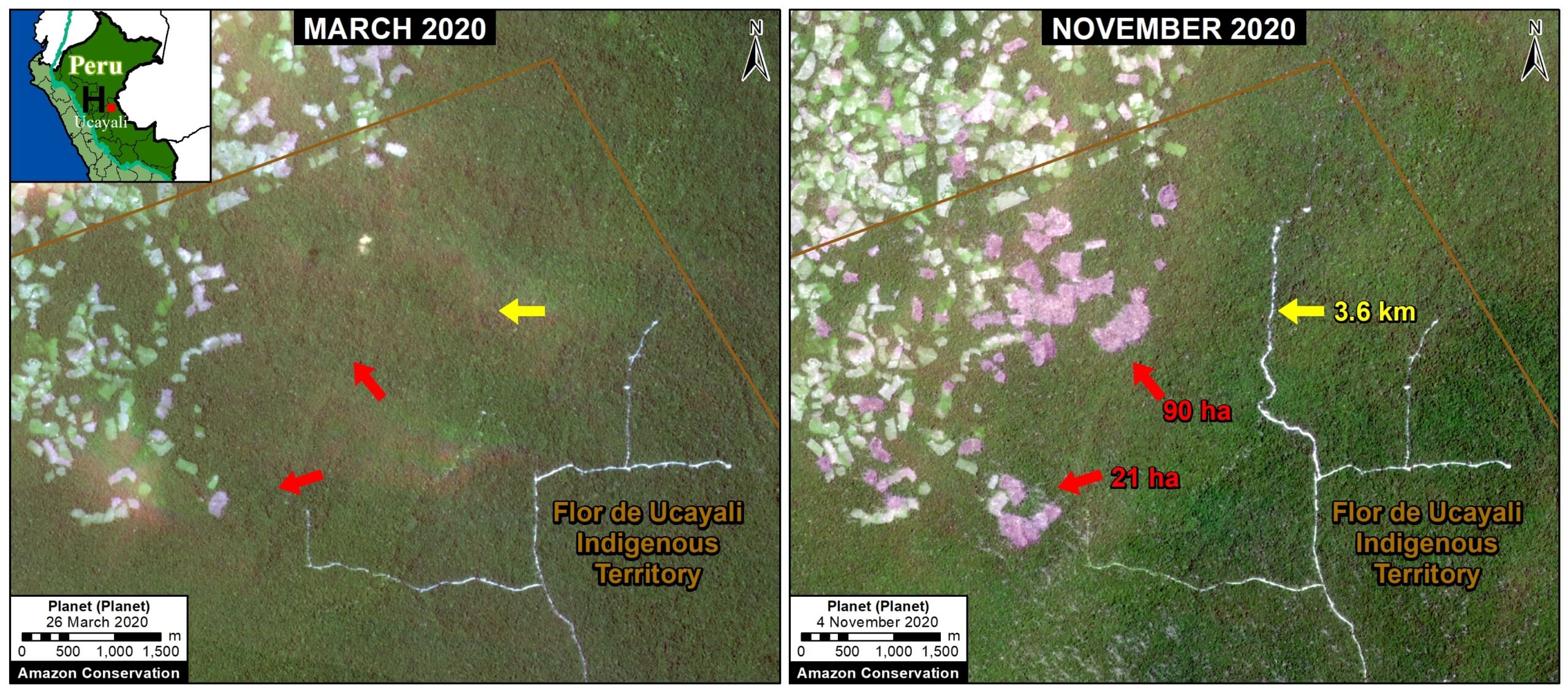
Deforestation in the central Peruvian Amazon

Finally, Zoom H shows expanding deforestation (over 110 hectares), and logging road construction (3.6 km), in an indigenous territory south of Sierra del Divisor National Park in the central Peruvian Amazon (Ucayali region). The deforestation appears to be associated with an expanding small-scale agriculture or cattle pasture frontier.

Zoom H. Deforestation and logging road construction in Peruvian Amazon (Ucayali region) between March (left panel) and November (right panel) 2020. Data: Planet.

*Notes and Methodology

The analysis was based on early warning forest loss alerts known as GLAD alerts (30-meter resolution) produced by the University of Maryland and also presented by Global Forest Watch. It is critical to highlight that this data represents a preliminary estimate and more definitive data will come later in the year. For example, our estimate does include some forest loss caused by natural forces. Note that this data detects and classifies burned areas as forest loss. Our estimate includes both confirmed (1,355,671 million hectares) and unconfirmed (751,533 ha) alerts.

Our geographic range is the biogeographic boundary of the Amazon as defined by RAISG (see Base Map above). This range includes nine countries.

We applied a filter to calculate only primary forest loss. For our estimate of primary forest loss, we intersected the forest cover loss data with the additional dataset “primary humid tropical forests” as of 2001 (Turubanova et al 2018). For more details on this part of the methodology, see the Technical Blog from Global Forest Watch (Goldman and Weisse 2019).

To identify the deforestation hotspots, we conducted a kernel density estimate. This type of analysis calculates the magnitude per unit area of a particular phenomenon, in this case forest cover loss. We conducted this analysis using the Kernel Density tool from Spatial Analyst Tool Box of ArcGIS. We used the following parameters:

Search Radius: 15000 layer units (meters)
Kernel Density Function: Quartic kernel function
Cell Size in the map: 200 x 200 meters (4 hectares)
Everything else was left to the default setting.

For the Base Map, we used the following concentration percentages: Medium: 7-10%; High: 11-20%; Very High: >20%.

Acknowledgements

We thank E. Ortiz (AAF), M.E. Gutierrez (ACCA), and S. Novoa for their helpful comments on this report.

Citation

Finer M, Mamani N (2020) Amazon Deforestation Hotspots 2020. MAAP: 132.


20 for 20: Photographing the First Recorded Melanistic Jaguar in Bolivia With Camera Traps

Melanistic jaguar as part of 20 for 20 Years of Conservation Wins by Amazon ConservationOur camera trap program has been implemented in our areas of work in Bolivia since 2015. We have camera traps placed in:

  • TCO Tacana II, an indigenous territory we’ve worked with for decades in the North of the Department of La Paz,
  • Santa Rosa del Abuná Integral Model Area, a conservation area we helped create in the department of Pando,
  • Manuripi National Wildlife Reserve National Protected Area, an area for conservation we’ve been supporting also in the Department of Pando.

These places have successfully managed to register a wide variety of wild species, and have even photographed a very unique melanistic jaguar (Panthera onca). This is a color morph which occurs at about 6% frequency in jaguar populations, giving it an almost “black” look that is a stark contrast to the species normal orange/ brown complexion. This is the first time this type of jaguar has ever been recorded in the entire country of Bolivia.

Additionally, our camera traps have recorded evidence of animals which had previously been declared as no longer living in the area, as well as ones that have been categorized as endangered, near-threatened, or vulnerable by the internationally-recognized IUCN Red List of threatened species, including endangered giant otter (Pteronura brasiliensis), near-threatened jaguar (Pantera onca), bush dog (Speothos venaticus), and harpy eagle (Harpia harpyja), as well as the vulnerable white-lipped peccary (Tayassu pecari) and South American tapir (Tapirus terrestris).

This story is part of a series commemorating our 20th anniversary protecting the Amazon. We’re celebrating this milestone with a look back at our 20 biggest conservation wins over the past 20 years. Click here to support camera trap conservation programs in the Amazon.

Drones Empower Community Members to Take Part in Reporting and Stopping Crimes Against Their Forests


southwest amazon drone center
Our Southwest Amazon Drone Center is training local landowners, forest users, indigenous communities, students, and government officials to use cutting-edge satellite, smartphone, and drone technology to monitor and stop deforestation. We provide local people with the technology, knowledge, legal support, and connections they need to safely and effectively take action.

In 2019, we trained and certify 89 individuals in using drones and smartphone apps to detect illegal activities in remote areas of their forests, and report them using drone imagery as legally-admissible evidence for law enforcement to be able to take action and prosecute offenders.

Marcelina, Drone pilotSixteen of the new users were women, and their numbers continue to increase as we focus on their inclusion in this type of training. We also trained and helped the local association of forest users known as ACOMAT in carrying out 26 patrols using their newly-acquired technological capabilities (drones, satellite imagery and/or mobile applications). These patrols detected 16 incidents of illegal activity in 9 areas, and a total of 5 criminal complaints were filed with the local government of the Madre de Dios region of Peru, which are currently being addressed by the authorities. We were also able to hold six specialized trainings for volunteer community park guards (called Forest Custodians), who combine our technology with their traditional foot patrols inside protected areas.

southwest amazon drone center photo of logging
Drone footage of illegal logging in the area

Beyond directly providing the actual drone and smartphone technology to these communities and individuals, we also provide continued training, certifications, and drone maintenance workshops to support their long-term fight to keep forests protected. This approach has been become so successful that it is known as the “ACOMAT Model” in Peru, and, due to its high demand, we are beginning to replicate it in other areas of Peru in addition to making it available to other countries in the Amazon.

All in all, this work marks a key first step for communities to effectively engage the government and compel them to take action by providing clear evidence of illegal activities in a timely (meaning in real time – while the illegal activity is still going on), cost effective, high-tech way.

Click here to read how ACOMAT members were recently able to detect illegal logging via drones.

Special thanks to The Sheldon and Audrey Katz Foundation, the members of the Cloud Appreciation Society, the
Norwegian Agency for Development Cooperation, and all individuals and organizations whose generous support made this project possible.

Understanding The Birds Of Tahuamanu

Woodcreeper birdOur bird survey at the Tahuamanu Biological Station is determining the ornithological diversity that the area protects, as well as establishes a baseline for their conservation and the development of birdwatching activities for ecotourists.

This project was carried out by creating two field camps for the researchers to cover all of the major habitat types. The first camp was based at the Tahuamanu station itself, from which the tours to the nearby Tahuamanu River area were made, enabling researchers to visit the lowland Amazonian forests and bamboo forests. The second camp was located outside the station, in order to understand the abundance and diversity of birds in the surrounding areas including unique riverbanks, grasslands and other lowland forests.

Researchers at both camps used a “Play Back” method (a best practice proposed in the research of Villareal et al. 2004), which consists of using recordings of birds at a moderate volume to draw them Comparison Graphnear, combined with a very light weight 40-foot net to capture the ones that fly by. Once captured, the birds were safely identified and photographed and released back into their habitat. We used world-class specialized field biology guides to ensure the proper identification and classification of these birds.

In total, we identified 267 species of birds belonging to 179 genus and 49 taxonomy families. The best represented species were the flycatcher family (Tyrannidae) with 28 species, followed by Ovenbirds (Furnaridae) and Antbirds (Thamnophilidae) with 25 species each (see the figure below for an overall distribution of the most commonly-found species).

Rufous-fronted antthrushTwelve of these species were listed under different categories of threat on the IUCN Red List, such as the endangered White-bellied parrot (Pionites leucogaster) and the Channel-billed Toucan (Ramphastos vitellinus).

Additionally, this species of Rufous-fronted antthrush is known in just two places in Bolivia. Living in riverbanks, it is difficult to observe as it’s very elusive. We were able to capture and photograph this bird as part of this project, which shows the importance of conservation areas and research stations like Tahuamanu in keeping threatened species like this one thriving.

Lastly, we also were able to identify four new species that were never recorded before in this area! These 267 Total species recorded, 12 threatened species identified, 4 new species found graphicspecies were the White-throated King bird (Tyrannus albogularis), Slender-billed Xenops (Xenops tenuirostris), Elegant Woodcreeper (Xiphorhynchus elegans), and the Ocellated Woodcreeper (Xiphorhynchus ocellatus). These findings add another layer of value to demonstrate to local authorities and communities the importance of protecting this area: to avoid the extinction of these species, let scientists know where they can go to conduct avian research, and where ecotourists can go to observe these species.

Special thanks to The Sheldon and Audrey Katz Foundation for their generous support that makes this project possible.

MAAP: Fires In The Bolivian Amazon 2020

Base Map. Major fires in the Bolivian Amazon during 2020. Data: MAAP/ACEAA.

We have detected 120 major fires this year in the Bolivian Amazon, as of the first of October (see Base Map).*

The majority of these fires (54%) occurred in savannas, located in the department of Beni.

Another 38% of the major fires were located in forests, mostly in the dry forests of the Chiquitano.

We emphasize that 25% of the major fires were located in Protected Areas (see below).


*The data, updated through October 1, is based on our novel real-time Amazon Fires Monitoring app, which is based on the detection of elevated aerosol emissions (by the European Space Agency’s Sentinel-5 satellite) that indicate the burning of large amounts of biomass (defined here as a “major fire”).


Major Fires in Protected Areas of the Bolivian Amazon in 2020. Data: MAAP/ACEAA.

Major Fires in Protected Areas

The most impacted Protected Areas are Noel Kempff Mercado National Park (21,000 acres burned), and Copaibo Municipal Protected Area (99,000 acres burned hectares).

Other impacted Protected Areas impacted include Iténez National Park, Keneth Lee Reserve and Pampas del Río Yacuma Integrated Management Natural Area.


Satellite Images of the Major Fires in the Bolivian Amazon

We present a series of high-resolution satellite images of the major fires in the Bolivian Amazon.

Image 1 shows a major fire in the extreme northwest of Noel Kempff Mercado National Park in September. Note that the fires are burning in the transition between Amazon forest and savanna.

Image 1. Major Fire #61 (Sept 8, 2020). Data: Planet.

Image 2 shows a major fire in Copaibo Municipal Protected Area in September. Note that it is located in the transition zone of the moist Amazon forest and Chiquitano dry forest.

Image 2. Major Fire #65 (September 7, 2020). Data: Planet.

Image 3 shows another major fire in Copaibo Municipal Protected Area, also in the transition zone of the Amazon forest and the Chiquitano dry forest.

Image 3. Major Fire #51 (September 4, 2020). Data: Planet.

Image 4 shows a major fire in the savannas of Beni.

Image 4. Major Fire #68 (September 12, 2020). Data: Planet.


Citation

Finer M, Ariñez A (2020) Fires in the Bolivian Amazon 2020. MAAP.

Establishing Bolivia’s Largest Conservation Area

Supporting  local government and communities to protect 3.7 million acres of pristine forests, savannas, and wetlands.

Photo of Bajo Madidi

In 2019, we helped the local government of Ixiamas, Bolivia establish the Municipal Conservation Area of Bajo Madidi, an area spanning 3.7 million acres (1.5 million hectares). Three times the size of the Grand Canyon, this conservation area is the largest in Bolivia and one of the largest in the world. It hosts a variety of ecological landscapes including wetlands, lowland rainforests, and savannas.


Photo of Bolivia: Marsh deer
Marsh deer

Throughout the long and complex creation process, we provided the technical expertise and assistance to both the government and local communities that was needed to officially declare the area. We also helped them gather and understand key environmental data on the conservation needs of this landscape to develop the plan to protect it for the long-term. This conservation plan now guides the sustainable use and management of natural resources in Bajo Madidi.

Photo of Orinoco Goose
Orinoco goose

This area’s value lies in its major biological significance. While many savannas in Bolivia have been transformed by cattle ranching or road construction, the savannas within Bajo Madidi remain some of the most ecologically-intact savannas in the world. They are home to more than 20 endangered species such as the maned wolf, Orinoco goose, marsh deer, black-faced spider monkey, and the giant anteater, all categorized as “vulnerable” or “threatened” on the IUCN Red List of Threatened Species.


The protected area will also protect the six rivers that flow through Bajo Madidi, safeguarding critical watersheds and aiding migration of birds, fish, and other animals that contribute to the overall rainforest health. Additionally, it will help maintain local The Madre de Dios River at sunset. communities’ sustainable harvesting of herbs, fruits, and nuts. This forest alone contains nearly 10% of the world’s Brazil nut trees under production. It also connects nearby nature reserves, creating an important biodiversity corridor of protected lands in the region.

The establishment of this area was a massive undertaking with contributions by local peoples and support from over 800 stakeholders. Successes like these are the foundation of our conservation efforts that have helped protect over 8.3 million acres of forests to date. 

This was a story from our 2019 Impact Report. Click here to read about other conservation successes from 2019.

Amazon Fire Tracker 2020: End Of August Update (Over 600 Major Fires)

August 2020 just ended its run as a severe Amazon fire month.

Brazilian Amazon Major Fire #584, August 2020. Data: Planet. Analysis: MAAP.Our novel Real-time Amazon Fire Monitoring app has detected 646 major fires in the Brazilian Amazon thus far in 2020.*

Of these, 88% (569 major fires) occurred in August,* and all were illegal, occuring after the burning moratoriums established in July.

Also in August, we saw the sudden appearance of “Forest Fires,” defined here as human-caused fires in standing forest. We detected 82 forest fires in August, which now account for 13% of all the major fires.*

The vast majority of the major fires (79%) continue to burn recently deforested areas, defined here as areas where the forest was previously and recently cleared (between 2018-20) prior to burning.

In fact, over 1.1 million acres (453,000 hectares) of recently deforested areas has burned in 2020. Thus, the fires are actually a smoking indicator of the current rampant deforestation in the Brazilian Amazon.

Base Map

The Base Map is a screen shot of the app’s “Major Amazon Fires 2020” layer (as of September 1). The majority of the major fires in the Brazilian Amazon have been in the states of Pará (37%) and Amazonas (33%), followed by Mato Grosso (16%), Rondônia (13%), and Acre (1%).

The app has detected an additional 58 major fires in the Bolivian Amazon thus far in 2020. The majority of these (71%) have occured in savanna ecosystems in the department of Beni.

Screen shot of the app’s “Major Amazon Fires 2020” layer (as of September 1).

*Notes and Methodology

Data updated as of September 1, starting from the first major fire detected on May 28.

We detected 569 major fires during August in the Brazilian Amazon.

Prior to August, we detected only one forest fire, and that was on July 31.

The app specializes in filtering out thousands of the traditional heat-based fire alerts to prioritize only those burning large amounts of biomass (defined here as a major fire).

In a novel approach, the app combines data from the atmosphere (aerosol emissions in smoke) and the ground (heat anomaly alerts) to effectively detect and visualize major Amazon fires.

When fires burn, they emit gases and aerosols. A new satellite (Sentinel-5P from the European Space Agency) detects these aerosol emissions. Thus, the major feature of the app is detecting elevated aerosol emissions which in turn indicate the burning of large amounts of biomass. For example, the app distinguishes small fires clearing old fields (and burning little biomass) from larger fires burning recently deforested areas or standing forest (and burning lots of biomass).

We define “major fire” as one showing elevated aerosol emission levels on the app, thus indicating the burning of elevated levels of biomass. This typically translates to an aerosol index of >1 (or cyan-green to red on the app). To identify the exact source of the elevated emissions, we reduce the intensity of aerosol data in order to see the underlying terrestrial heat-based fire alerts. Typically for major fires, there is a large cluster of alerts. The major fires are then confirmed, and burn areas estimated, using high-resolution satellite imagery from Planet Explorer.

See MAAP #118 for additional details on how to use the app.

No fires permitted in the Brazilian state of Mato Grosso after July 1, 2020. No fires permitted in all of Brazilian Amazon after July 15, 2020. Thus, we defined “illegal” as any major fires detected after these respective dates.

A major fire may be classified as burning across multiple land categories (for example, both recently deforested area and surrounding forest fire) so those percentages do not total 100%.

There was no available Sentinel-5 aerosol data on July 4, 15, and 26.


Acknowledgements

The app was developed and updated daily by Conservación Amazónica (ACCA). The data analysis is led by Amazon Conservation in collaboration with SERVIR Amazonia.


Citation

Finer M, Vale H, Villa L, A. Ariñez, Nicolau A, Walker K (2020) Amazon Fire Tracker 2020: End of August Update (Over 600 Major Fires). MAAP.

153,000 Acres Of Brazil Nut Forests Protected by Amazon Conservation and Google

 Brazil nut concessionaires walking in forest
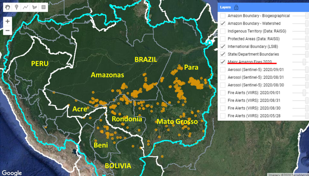
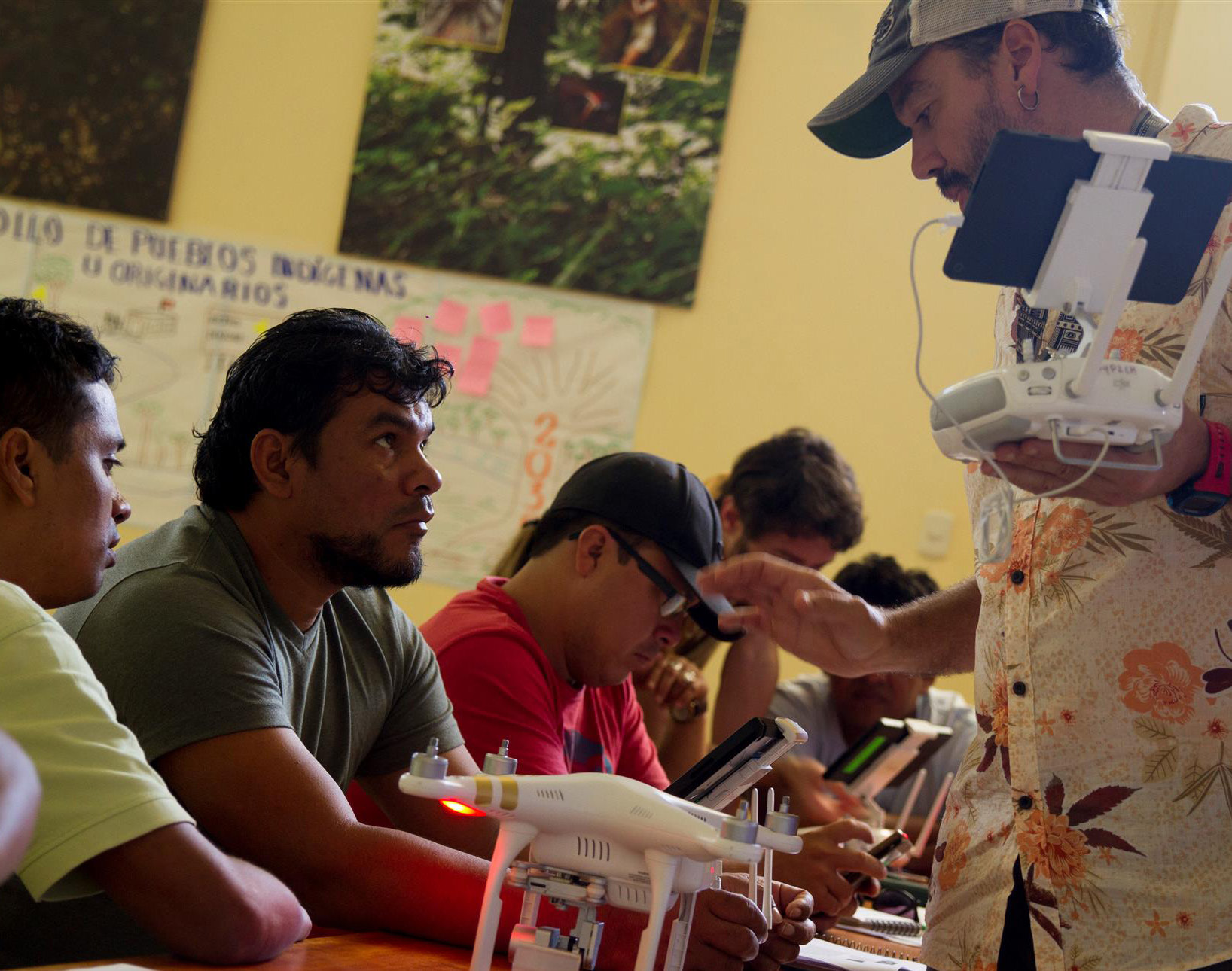
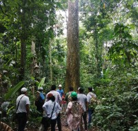
Amazon Conservation’s sister organization Conservación Amazónica – ACCA, with support from Google.org, just finished up a two-year initiative that trained community members to use cutting-edge satellite and field technologies to combat deforestation in the southern Peruvian Amazon, now protecting over 150,000 acres of lowland forests.

This initiative trained 75 Brazil nut harvesters and their families in forest monitoring technologies, which will help them safeguard forests to be used for sustainable purposes. Preventing deforestation of natural resources is not only environmentally important, but also economically, as the productive forests in and around the Madre de Dios area in Peru provide a sustainable and forest-friendly economic income to around 45,000 people, about 20% of the population.

In Peru, local families or associations can be granted a piece of public forests to be used for specific purposes – called a concession – such as harvesting nuts and berries, or for ecotourism. This system prevents acres of forests from falling victim to destructive activities, such as land squatting, illegal logging, or invasions by gold miners. Additionally, concessionaires are required by law to report on illicit activities in their concessions, which is a way the government gets community support to protect large swaths of forests.

Brazil nut concessionaires
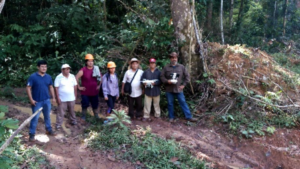
Before this program, concessionaires and their communities lacked capacity to monitor these large, remote areas and a way to rapidly and safely report deforestation in their territories. Our innovative methodology of combining real-time satellite imagery analysis and drone field technology (which includes smartapps and other technologies developed by Google) with legal training, gave concessionaires the ability to detect and report deforestation as it happened in their territory. This is a stark contrast from before, when the only way to monitor thousands of acres of forests was through foot patrols that took days to complete. 

Now 75 Brazil nut harvesters and their families are using satellite imagery, early deforestation alerts, and GPS applications on mobile devices to monitor their forests. Among them, 23 individuals successfully obtained their licenses as drone pilots from the Ministry of Transport and Communications’ General Directorate of Civil Aeronautics. This means they can now their entire territory in minutes, without having to face potential risks of confronting dangerous individuals committing environmental crimes or even running into outsiders who might bring diseases like the novel coronavirus into their communities. 

Brazil nut appetizers
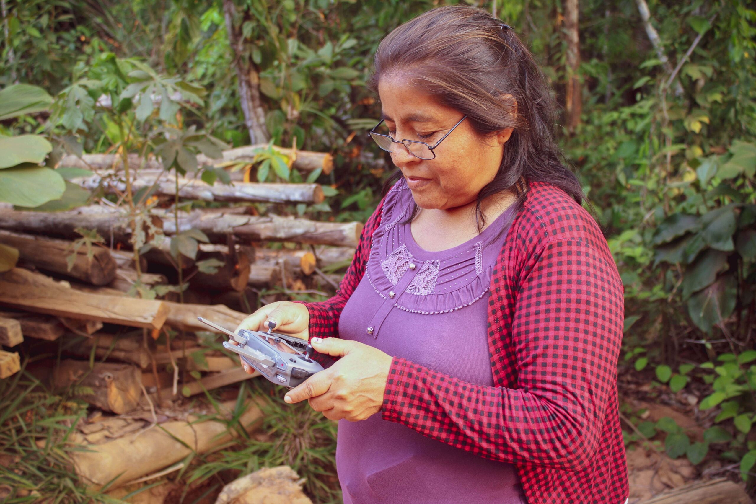
Through this program, over 153,000 acres (62,000 hectares) of forests are now monitored and protected with technology by the local people we empowered. Moreover, technological kits were donated to each individual or local association, each containing a drone, a maintenance kit, a laptop and a printer, giving them the knowledge and tools needed to safeguard forests..

These successes were celebrated with a closing ceremony in the Castaña Amazon Park earlier this year. Local authorities and representatives of local organizations attended, such as the director of the Research Institute of the Peruvian Amazon (IIAP) and members of local harvesting associations. During the ceremony, attendees enjoyed Brazil nut appetizers, while watching presentations about the project, the results achieved, and the collaborators and participants. The event ended with a guided tour of the Brazil Nut Harvesting Center in the Castaña Amazon Park, which is noted as the first living Brazil nut tree park in the world.

Presenter at Brazil Nut Google Event
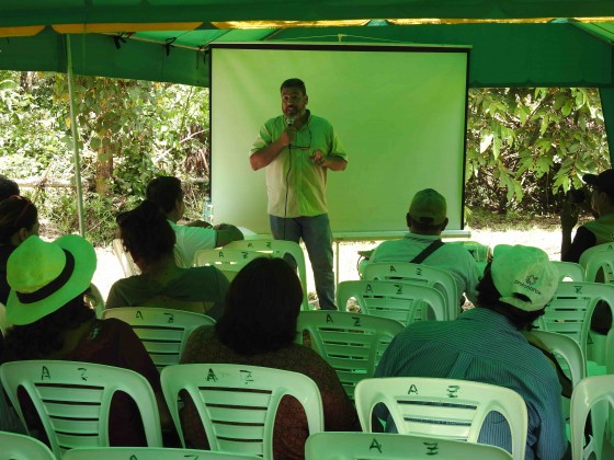
The project, led by our director of our Southwest Amazon Drone Center, Carlos Castañeda, will continue to provide technical support to maintain the donated drones and training to reinforce what they learned, as well as be available to answer any questions that may arise during monitoring and surveillance of their concessions. Thus, the continuity of the project and its sustainability are ensured.

This Google.org-funded project was the first of its kind nationwide in Peru. After this success, Amazon Conservation continues its mission of conserving the Amazon basin using new technologies. Over the next three years, we hope to strengthen the real-time monitoring of the forests by empowering local people and employing science and technology as a proven way to fight deforestation in the Amazon and create a model for other tropical forests around the world.

Bringing Climate Resilience to Local Communities

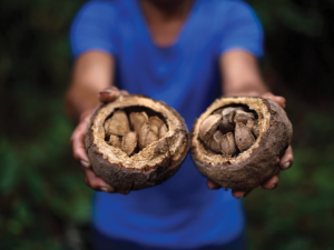
For the past year our team in Bolivia and Peru have been working with EUROCLIMA+, an initiative of the European Commission focused on combating climate change in Latin America. We are working with local communities to pilot climate change resilience in their sustainable use of forest resources.

Promoting sustainable forest resources is important for keeping forests standing, and an initiative that we have been expanding for many years now. The Amazon rainforest is full of economically valuable products, such as the Brazil nuts and açaí berries, which are important sources of income for local communities. These fruits can only grow in standing forests, and cannot survive in a monoculture or farmed operation setting. 


An Economic Essential

Luis Arteaga, our Technical Director i
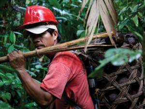
n Bolivia, coordinates this project. His team works in the northern part of Bolivia, where local communities heavily depend on these forest goods to make a living. “Almost all the families dedicate themselves to harvesting forest fruits, mainly the Brazil nut, which is their main economic activity.” 

Noting the ecological makeup of the area, one can see why: the northern municipality of the Santa Rosa del Ábuna conservation area has the highest concentration of Brazil nut trees in the department of Pando, Bolivia. These nuts generate up to 90% of local families’ overall income, and although harvesting is a job that requires a lot of dedication and back-breaking work, it generates important opportunities for commercialization and sustainable forest management. Luis puts it simply, “If Brazil nuts didn’t exist or didn’t grow in these forests, they would have already been cut down for another economic activity.” 

bags of brazil nuts
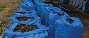
Tying the importance of conservation of these forests not only to climate change but also to economic sustainability of local and global economies is vital for countries and communities to see the value of forests. In fact, our area of work in Bolivia holds 85% of the Brazil nut production in the world, and keeping those forests standing through sustainable activities will have a significant impact in the fight against deforestation and carbon emissions.


Confronting Climate Change

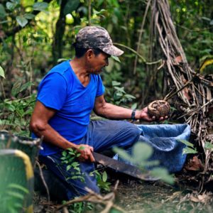
A key aspect of our work with EUROCLIMA+ is recognizing how these sustainable forest economies help mitigate the effects of climate change on communities and on the planet, which hadn’t previously been as much on peoples’ minds. This pilot work is also helping local communities become aware of how climate is changing the forests on which they depend, so they can plan for their long-term, sustainable use, without needing to turn to destructive practices like timber extraction and cattle ranching if a harvesting season is affected by global warming. This involves not only making sure we have healthy forests, but also helping communities diversify their source of income sustainably, such as harvesting other complementary forest products like açaí berries and sustainably farming paiche fish. 
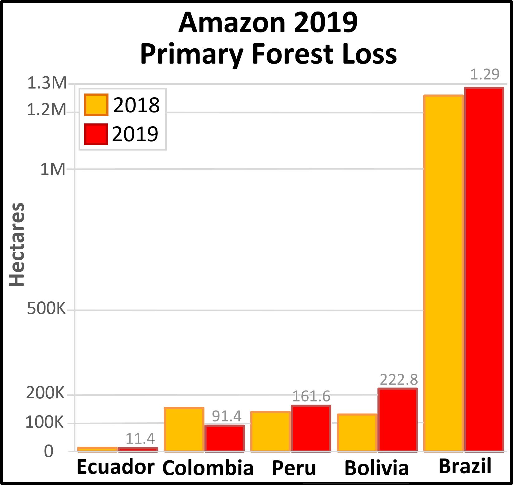
“In my opinion,” Luis notes, “one important advancement is that we are learning how climate change has impacted, is impacting, and will impact this vital bi-national region of the Amazon in Peru and Bolivia. Working with EUROCLIMA+ has taught us to use the climate lens to think about all of our future conservation work as well, and this is a good step forward.”

MAAP #122: Amazon Deforestation 2019

Newly released data for 2019 reveals the loss of over 1.7 million hectares (4.3 million acres) of primary Amazon forest in our 5 country study area (Bolivia, Brazil, Colombia, Ecuador, and Peru).* That is twice the size of Yellowstone National Park.

Table 1 shows 2019 deforestation (red) in relation to 2018 (orange).

Table 1. Amazon 2019 primary forest loss for 2019 (red) compared to 2018 (orange). Data: Hansen/UMD/Google/USGS/NASA, MAAP.

Primary forest loss in the Brazilian Amazon (1.29 million hectares) was over 3.5 times higher than the other four countries combined, with a slight increase in 2019 relative to 2018. Many of these areas were cleared in the first half of the year and then burned in August, generating international attention.

Primary forest loss rose sharply in the Bolivian Amazon (222,834 hectares), largely due to uncontrolled fires escaping into the dry forests of the southern Amazon.

Primary forest loss rose slightly in the Peruvian Amazon (161,625 hectares) despite a relatively successful crackdown on illegal gold mining, pointing to small-scale agriculture (and cattle) as the main driver.

On the positive side, primary forest loss decreased in the Colombian Amazon (91,400 hectares) following a major spike following the 2016 peace accords (between the government and FARC). It is worth noting, however, that we have now documented the loss of 444,000 hectares (over a million acres) of primary forest in the Colombian Amazon in the past four years since the peace agreement (see Annex).

*Two important points about the data. First, we use annual forest loss from the University of Maryland to have a consistent source across all five countries. Second, we applied a filter to only include loss of primary forest (see Methodology).


2019 Deforestation Hotspots Map

The Base Map below shows the major 2019 deforestation hotspots across the Amazon.

2019 deforestation hotspots across the Amazon. Data: Hansen/UMD/Google/USGS/NASA, MAAP.

Many of the major deforestation hotspots were in Brazil. Early in the year, in March, there were uncontrolled fires up north in the state of Roraima. Further south, along the Trans-Amazonian Highway, much of the deforestation occurred in the first half of the year, followed by the high profile fires starting in late July. Note that many of these fires were burning recently deforested areas, and were not uncontrolled forest fires (MAAP #113).

The Brazilian Amazon also experienced escalating gold mining deforestation in indigenous territories (MAAP #116).

Bolivia also had an intense 2019 fire season. Unlike Brazil, many were uncontrolled fires, particularly in the Beni grasslands and Chiquitano dry forests of the southern Bolivian Amazon (MAAP #108).

In Peru, although illegal gold mining deforestation decreased (MAAP #121), small-scale agriculture (including cattle) continues to be a major driver in the central Amazon (MAAP #112) and an emerging driver in the south.

In Colombia, there is an “arc of deforestation” in the northwestern Amazon. This arc includes four protected areas (Tinigua, Chiribiquete and Macarena National Parks, and Nukak National Reserve) and two Indigenous Reserves (Resguardos Indígenas Nukak-Maku and Llanos del Yari-Yaguara II) experiencing substantial deforestation (MAAP #120). One of the main deforestation drivers in the region is conversion to pasture for land grabbing or cattle ranching.

Annex – Colombia peace accord trend

Table 1. Deforestation of primary forest in the Colombian Amazon, 2015-20. Data: Hansen/UMD/Google/USGS/NASA, UMD/GLAD. *Until May 2020

Methodology

The baseline forest loss data presented in this report were generated by the Global Land Analysis and Discovery (GLAD) laboratory at the University of Maryland (Hansen et al 2013) and presented by Global Forest Watch. Our study area is strictly what is highlighted in the Base Map.

For our estimate of primary forest loss, we used the annual “forest cover loss” data with density >30% of the “tree cover” from the year 2001. Then we intersected the forest cover loss data with the additional dataset “primary humid tropical forests” as of 2001 (Turubanova et al 2018). For more details on this part of the methodology, see the Technical Blog from Global Forest Watch (Goldman and Weisse 2019).

For boundaries, we used the biogeographical limit (as defined by RAISG) for all countries except Bolivia, where we used the Amazon watershed limit (see Base Map).

All data were processed under the geographical coordinate system WGS 1984. To calculate the areas in metric units, the projection was: Peru and Ecuador UTM 18 South, Bolivia UTM 20 South, Colombia MAGNA-Bogotá, and Brazil Eckert IV.

Lastly, to identify the deforestation hotspots, we conducted a kernel density estimate. This type of analysis calculates the magnitude per unit area of a particular phenomenon, in this case forest cover loss. We conducted this analysis using the Kernel Density tool from Spatial Analyst Tool Box of ArcGIS. We used the following parameters:

Search Radius: 15000 layer units (meters)
Kernel Density Function: Quartic kernel function
Cell Size in the map: 200 x 200 meters (4 hectares)
Everything else was left to the default setting.

For the Base Map, we used the following concentration percentages: Medium: 7%-10%; High: 11%-20%; Very High: >20%.

References

Goldman L, Weisse M (2019) Explicación de la Actualización de Datos de 2018 de Global Forest Watch. https://blog.globalforestwatch.org/data-and-research/blog-tecnico-explicacion-de-la-actualizacion-de-datos-de-2018-de-global-forest-watch

Hansen, M. C., P. V. Potapov, R. Moore, M. Hancher, S. A. Turubanova, A. Tyukavina, D. Thau, S. V. Stehman, S. J. Goetz, T. R. Loveland, A. Kommareddy, A. Egorov, L. Chini, C. O. Justice, and J. R. G. Townshend. 2013. “High-Resolution Global Maps of 21st-Century Forest Cover Change.” Science 342 (15 November): 850–53. Data available on-line from: http://earthenginepartners.appspot.com/science-2013-global-forest.

Turubanova S., Potapov P., Tyukavina, A., and Hansen M. (2018) Ongoing primary forest loss in Brazil, Democratic Republic of the Congo, and Indonesia. Environmental Research Letters  https://doi.org/10.1088/1748-9326/aacd1c 

Acknowledgements

We thank G. Palacios for helpful comments to earlier versions of this report.

This work was supported by the following major funders: Norwegian Agency for Development Cooperation (NORAD), Gordon and Betty Moore Foundation, International Conservation Fund of Canada (ICFC), Metabolic Studio, Erol Foundation, MacArthur Foundation, and Global Forest Watch Small Grants Fund (WRI).

Citation

Finer M, Mamani N (2020) 2019 Amazon Deforestation. MAAP: 122.