
Between January and September 2025, roughly 400 hectares, an area comparable to about 570 soccer Fields, were deforested as a result of illegal mining in the Xingu. The destruction adds to the mounting pressure on Indigenous territories and protected areas across the Brazilian Amazon. The analysis shows that isolated enforcement operations have been insufficient to halt the advance of mining activities, underscoring the need for structural, long-term strategies to address the problem.
Despite the persistent threat posed by illegal mining in the Amazon, particularly within Indigenous Lands and protected areas, new data reveal that this activity is advancing faster and more aggressively in the Xingu region. The findings raise serious concerns about escalating risks to the forest and the communities that depend on it. The analysis, carried out by the MAAP (Monitoring of the Andes Amazon Program) initiative of Amazon Conservation in partnership with Instituto Socioambiental (ISA), which led the report, shows that mining‑driven deforestation continues to expand inside protected territories, even in the wake of recent enforcement operations.
According to the report, at least 11,500 hectares of forest were lost between 2018 and 2024 within Indigenous Lands and protected areas of the Xingu River Basin. An additional 400 hectares were cleared between January and September 2025, underscoring the ongoing and intensifying pressure on the region.
Territory under pressure
At the heart of this dynamic lies the Xingu Socio‑Environmental Diversity Corridor, one of the largest continuous expanses of officially protected forest on the planet. Covering more than 26 million hectares and linking 24 Indigenous Lands and 9 protected areas, the corridor plays a vital role in safeguarding the Amazon rainforest. Yet it remains under intensifying pressure from illegal mining, expanding agribusiness, illegal logging, and human‑induced forest fires.
This initial section of the study offers a detailed analysis of three Indigenous Lands: Kuruaya, Baú, and Kayapó, revealing how illegal mining has advanced in recent years and the direct impacts it has imposed on these territories and their communities.
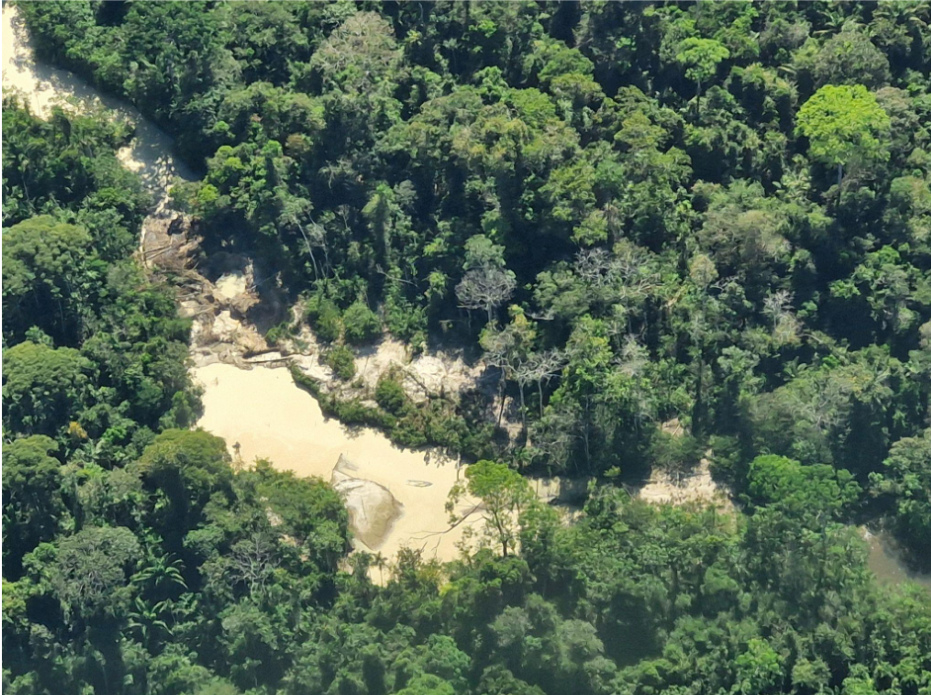
In the Kuruaya Indigenous Land, illegal mining has intensified along the Madalena River. Between 2023 and July 2025, the affected area surpassed 34 hectares. In the Baú Indigenous Land, the report identifies at least 110 hectares of destroyed forest, along with documented incidents of armed conflict between miners and Indigenous peoples.
The most critical situation is found in the Kayapó Indigenous Land, which contains the largest area deforested by illegal mining in the Brazilian Amazon. Data indicate a cumulative total of approximately 7,940 hectares impacted, with significant expansion continuing through 2025, even after government operations aimed at removing miners and machinery from the region.
“The data from both monitoring systems make it unmistakably clear that the Xingu Corridor is facing growing and widespread pressure, with illegal mining pushing into areas that had remained intact until now. Addressing this requires a long‑term, structural response to protect the integrity of these forests and the peoples who depend on them,” says Thaise Rodrigues, Geoprocessing Analyst at Instituto Socioambiental (ISA).
Technology and Monitoring Reveal Consistent Patterns
The report integrates data from two independent monitoring systems: SiRAD X, from the Xingu+ Network, and MAAP/Amazon Mining Watch. These systems rely on satellite imagery, radar, and artificial intelligence to detect mining activity. Despite methodological differences, both systems reveal consistent patterns of expansion over time.
The Xingu+ Network conducts monthly monitoring of deforestation and other pressures across the Xingu Corridor through SiRAD X (the Xingu Remote Deforestation Alert System), which uses radar technology. The system is further strengthened by a network of local partners who carry out direct, on‑the‑ground territorial surveillance.
In 2025, the Brazilian organization Instituto Socioambiental (ISA) formed a partnership with Amazon Conservation, expanding access to high‑resolution satellite imagery provided by Planet. This enhanced capability has improved the validation of alerts and the identification of key drivers of pressure. The collaboration also feeds into the public Amazon Mining Watch platform, developed jointly by Amazon Conservation, Earth Genome, and the Pulitzer Center.
The impacts of illegal mining extend far beyond deforestation. The activity contributes to mercury contamination of rivers, loss of biodiversity, and escalating socio‑environmental conflicts. These consequences threaten the safety and livelihoods of Indigenous and riverine communities, as well as urban populations that rely on forest and river resources and on the environmental services these ecosystems provide, including climate regulation.
“This is one of the most comprehensive analyses to date on the growing impact of gold mining in Indigenous Lands and protected areas within the Xingu Corridor, one of the main hotspots of mining activity in the Brazilian Amazon. By bringing together complementary and previously unavailable datasets, the study enhances our understanding of recent trends and helps guide more effective monitoring, enforcement, and decision‑making,” says Matt Finer, director of the MAAP program at Amazon Conservation
From response to action
The report underscores that isolated operations to remove illegal miners are insufficient to curb the problem. Among its key recommendations are the creation of a permanent, inter‑institutional task force to dismantle the logistical networks that sustain illegal mining; the strengthening of Brazilian enforcement agencies such as IBAMA, ICMBio, and FUNAI; the expansion of territorial monitoring led by Indigenous communities; and advances in gold‑supply‑chain traceability, with greater transparency regarding its origin.
Without a long‑term strategy, the study warns, there is a high risk that invasions will return soon after enforcement actions.
This report is part of a two‑part series on the expansion of illegal mining in the Xingu River Basin. This first edition analyzes impacts on Indigenous Lands, while the second will examine the advance of mining‑related deforestation in two additional Indigenous Lands (Trincheira Bacajá and Apyterewa ) and in five protected areas: the Altamira National Forest, the Iriri State Forest, the Riozinho do Anfrísio Extractive Reserve, the Nascentes da Serra do Cachimbo Biological Reserve, and the Rio Iriri Extractive Reserve, all located within the Xingu Corridor.
READ THE FULL REPORT HERE:
https://www.maapprogram.org/mining-xingu-brazil-indig/
About the Instituto Socioambiental
Guided by the motto “socioambiental [socioenvironmental] is written together,” the Instituto Socioambiental was founded in 1994. Since then, it has worked side by side with long‑standing partners from Indigenous, Quilombola, and traditional communities to develop solutions that protect and restore their territories, strengthen their cultures and traditional knowledge, expand their political and social representation, foster sustainable community‑led economies, and highlight their essential contributions to climate‑change adaptation and mitigation.
About MAAP
Monitoring of the Andes Amazon Project (MAAP), an initiative of Amazon Conservation, Conservación Amazónica–ACCA (Peru), and Conservación Amazónica–ACEAA (Bolivia), provides cutting-edge, real-time technical analysis on deforestation, mining and fires across the Amazon. MAAP uses satellite imagery, data science, and field information to generate timely reports that support conservation action and policy.
 Loading...


