
Once again, Peruvian bird-watching teams (including our own) placed very well during the 2017 Global Big Day that took place on May 13, observing the second-highest number of birds in the world, with 1,338 total species overall. This was just shy of Colombia’s 1,486 bird species but still beat last year’s Peru record of 1,177.
Author: dcadmin
Ornithologist Bob Ridgley raves about birding with Amazon Conservation
Recently, we hosted a distinguished American ornithologist at two of our birding lodges in southeastern Peru. Dr. Robert Ridgely, whose name is synonymous with South American ornithology, was impressed by the “extraordinary habitat” surrounding the lodges, calling the deeply forested transect from Wayqecha Birding Lodge, high in the Andes, down to Villa Carmen Birding Lodge is one of the “the biggest, wildest montane forests” on the planet.
Upcoming birding festivals – will we see you there?
There are many incredible birding festivals taking place in the US every year, and we love meeting new faces every time we attend one! This year, in addition to the Space Coast Birding Festival that we attended in early January, we’ll be sharing the experience of birding with us in the Peruvian Amazon at two upcoming events. If you’ll be in town, make sure to attend and say hello!
A sneak peek at our Los Amigos Birding Lodge
In the 2015 Global Big Day, Los Amigos Birding Lodge registered the fifth highest number of bird species in the world (308) – and with good reason. Not only do we have sharp-eyed bird guides stationed there, but Los Amigos is adjacent to the Los Amigos Conservation Concession and just east of world-famous Manu National Park, which means it is surrounded by millions of acres of protected wilderness.
MAAP #65: Deforestation Hotspots Of 2017 in The Peruvian Amazon
In an earlier report, MAAP #40, we highlighted the power of combining early warning GLAD* alerts with analysis of high-resolution satellite images (for example, from the company Planet), as part of a comprehensive near real-time deforestation monitoring system.
In the current report, we analyze the GLAD alerts for the first half of 2017 (through July 17) to identify current deforestation hotspots in the Peruvian Amazon.** These alerts indicate an estimated total forest loss of 37,000 acres (15,000 hectares) thus far during the year.
Image 65 (see right) highlights the 2017 deforestation hotspots, defined here as areas with medium to high density of forest loss.
Below, we describe and show images of the most intense hotspots, indicated in red and orange.
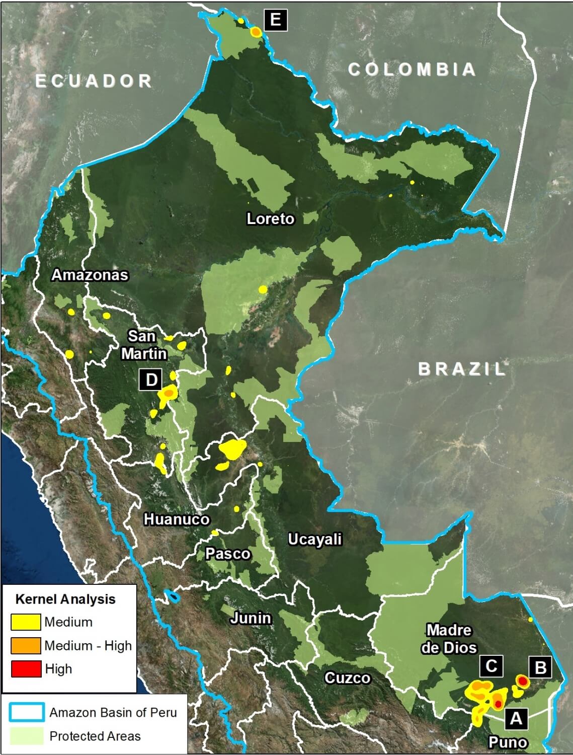
Image 65. Data: MINAM/PNCB, UMD/GLAD, SERNANP, MAAP
These areas include:
- Buffer zones of Tambopata National Reserve and Cordillera Azul National Park
- Natural loss due to blowdowns from “hurricane winds,” in the Madre de Dios region
- Northwest border with Colombia
MAAP #63: Patterns of Deforestation in the Colombian Amazon
We are excited to present our initial analysis of the Colombian Amazon, a work that reflects an important collaboration with our colleagues at Amazon Conservation Team. It is also our first report in the more interactive “Story Map” format.
This report has two objectives: 1) Illustrate the major deforestation hotspots in the Colombian Amazon between 2001 and 2015 and 2) Focus in on one of the most important hotspots, located in the Caquetá department. In short, we show satellite imagery of the expanding forest loss in one of the most important deforestation hotspots in the Colombian Amazon.
Please follow this link to view the Story Map: https://maaproject.org/maap-deforestation-patterns-colombian-amazon/
MAAP #62: Fire, Rain, And Deforestation in The Peruvian Amazon
In 2016, Peru experienced an intense forest fire season (MAAP #52, MAAP #53). A leading hypothesis was that intense drought facilitated the escape of agricultural burns. To investigate, this report analyzes the dynamic between fires and precipitation over the past 15 years, finding a strong temporal correlation (Image 62a). We also investigate the link between fires and forest loss, finding a spatial correlation.
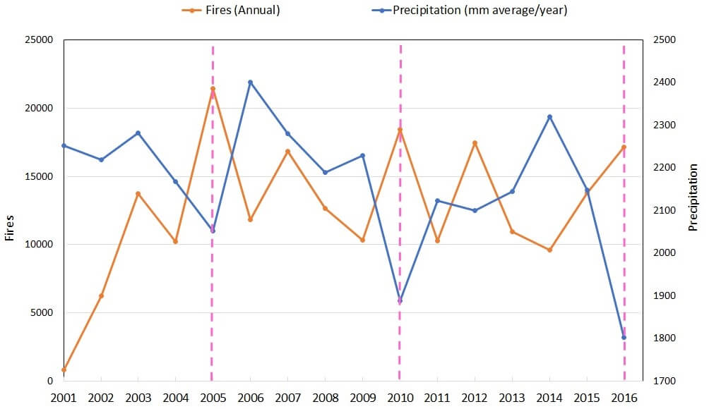
Image 62a. Data: TRMM, FIRMS/NASA, PNCB/MINAM, GLAD/UMD
MAAP #61: Illegal Gold Mining Decreases in Tambopata National Reserve
In the previous MAAP #60, we showed the rapidly increasing illegal gold mining deforestation in the buffer zone of Tambopata National Reserve. In contrast, here we show that the rate of illegal gold mining deforestation is decreasing within Tambopata National Reserve, due to the active interventions by the Peruvian Government. Tambopata is an important protected area in the southern Peruvian Amazon due to its high biodiversity.
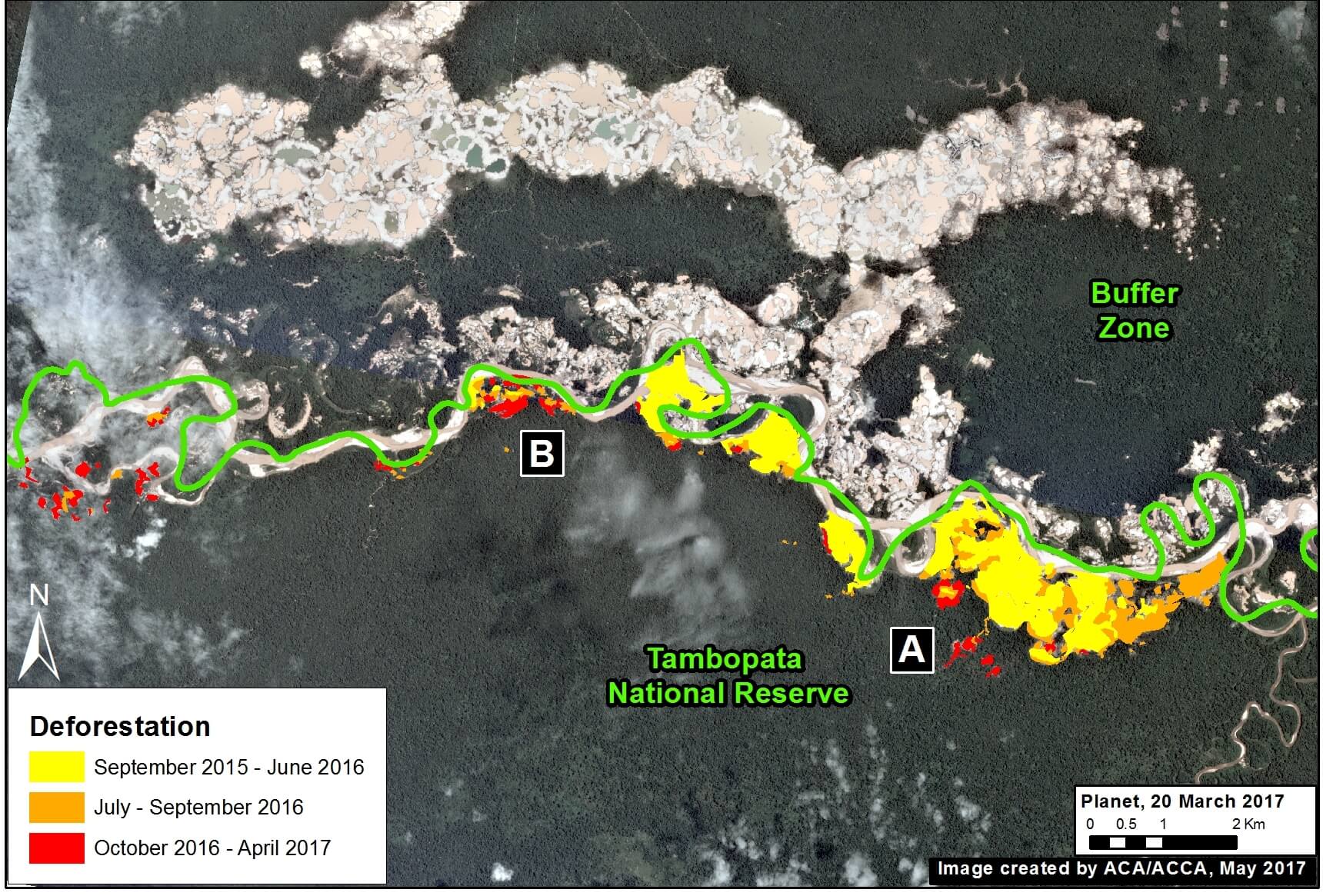
Image 61. Data: Planet, MAAP, SERNANP
MAAP #60: Gold Mining Increases in Buffer Zone Of Tambopata National Reserve
In the previous MAAP #50, we presented an analysis of the extent of gold mining deforestation in the southern Peruvian Amazon as of September 2016. Here, we partially update the data for the area within the buffer zone of Tambopata National Reserve.* We document the increase of 1,135 acres (460 hectares) of illegal mining deforestation during the last 8 months, from September 2016 to May 2017 (see red in Image 60). That brings the total deforested area in the buffer zone to 10,970 acres (4,440 hectares) since 2012.
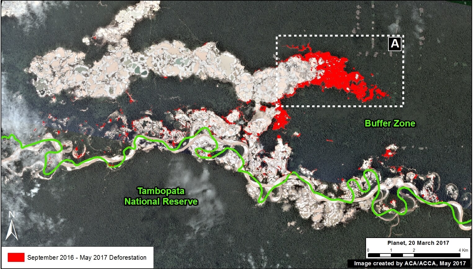
Image 60. Data: Planet, MAAP, SERNANP
*The buffer zone does not form part of the respective protected area, thus it is not under the jurisdiction of the Peruvian national protected areas agency, SERNANP. However, the illegal activities that are being carried out in the buffer zone are putting the conservation values of the protected area at risk, and are under the jurisdiction of other entities in the Peruvian government.
May 2017 Newsletter
Your monthly digest for all things conservation in the Amazon Rainforest.
 Loading...


