
Click the image above to access the full article featured in the October 2017 Birder’s Guide magazine. Sean Williams, PhD., one of LABO’s advisers, had a record-breaking Big Day in 2015 while staying at Los Amigos! Read his incredible article to find out more!
Uncategorized
MAAP #71: Gold Mining Threatens Amarakaeri Communal Reserve, Again
In an earlier series of articles (MAAP #6, MAAP #44, MAAP #64), we showed the illegal gold mining invasion of a section of Amarakaeri Communal Reserve (see yellow box in Base Map), as well as the rapid response by authorities to remove the miners. It was an important case given that Amarakaeri is an important Peruvian protected area, co-
managed byPeru’s protected areas agency (SERNANP) and indigenous communities (represented by the ECA Amarakaeri).
However, here we highlight the rapid advance of gold mining deforestation towards another section of Amarakaeri Communal Reserve, in the region of Cusco to the south (see purple box in Base Map).
*According to a statement from SERNANP, they are jointly coordinating with the ECA Amarakaeri and competent authorities such as the National Police, Prosecutor’s Office, and National Forest Service (SERFOR), regarding actions to stop the advance of illegal gold mining, and generating and comprehensive solutions to the problem.
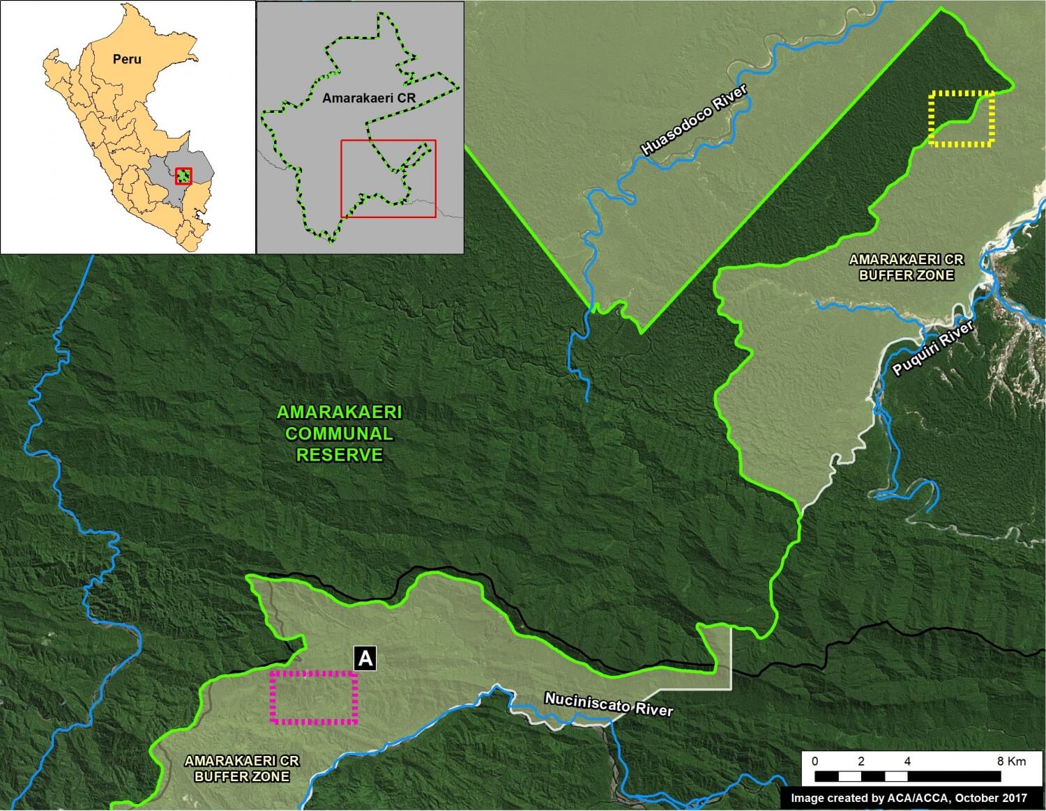
Image 71. Base Map
MAAP #70: “Hurricane Winds” In the Peruvian Amazon, A 13 Year Analysis
In an earlier report, MAAP #54, we described the natural phenomenon of “hurricane winds” in the Peruvian Amazon. These strong wind storms (not true hurricanes) cause a chain reaction of fallen trees and may blow down hundreds of acres of Amazonian forest (see Drone Image below).
This report presents an analysis of the frequency and intensity of hurricane winds in the Peruvian Amazon over the past 13 years (2005-17). The analysis is based on the annual forest loss data and early warning alerts data.
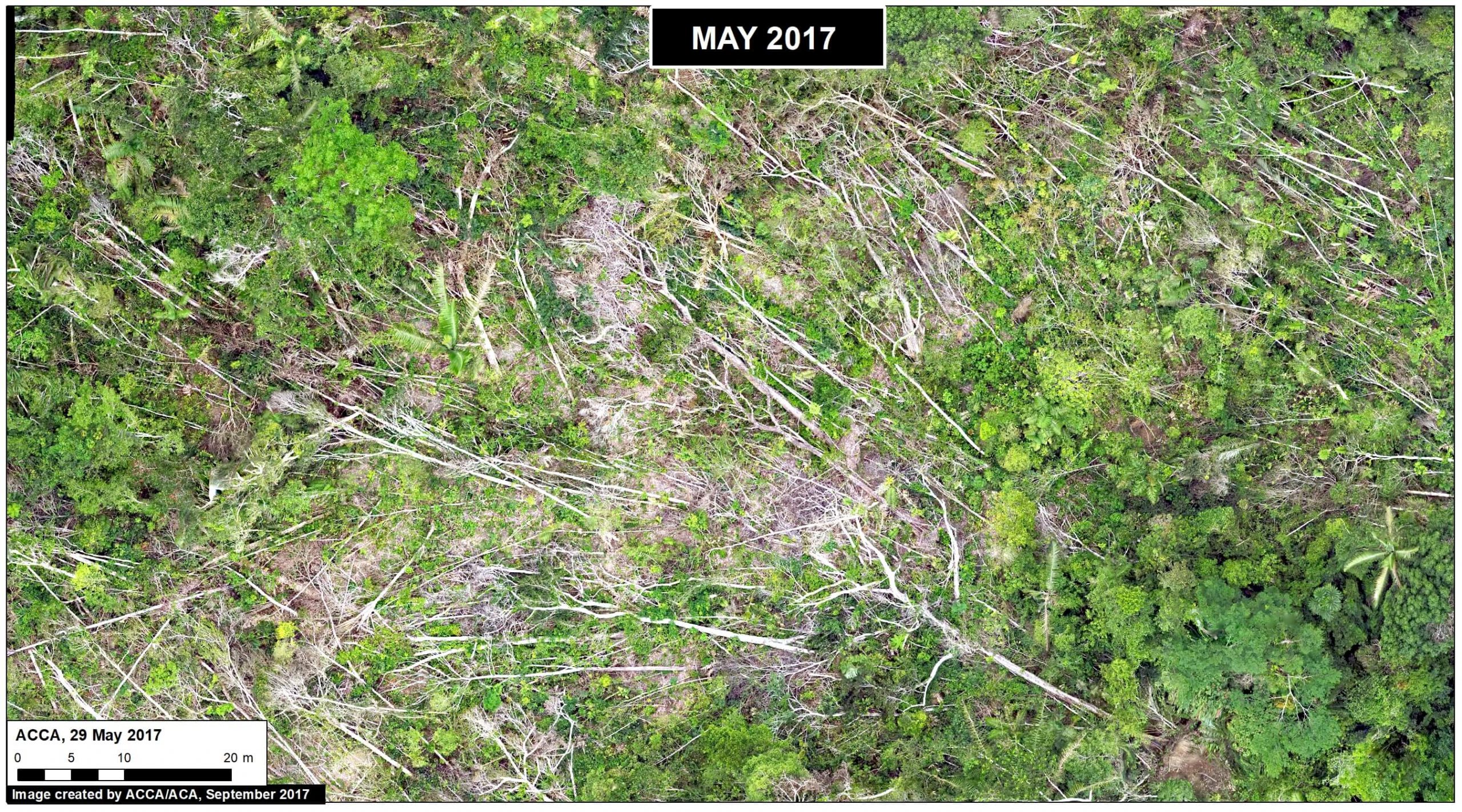
Drone Image. Source: ACCA
MAAP #69: Alarming Deforestation Patterns in The Central Peruvian Amazon
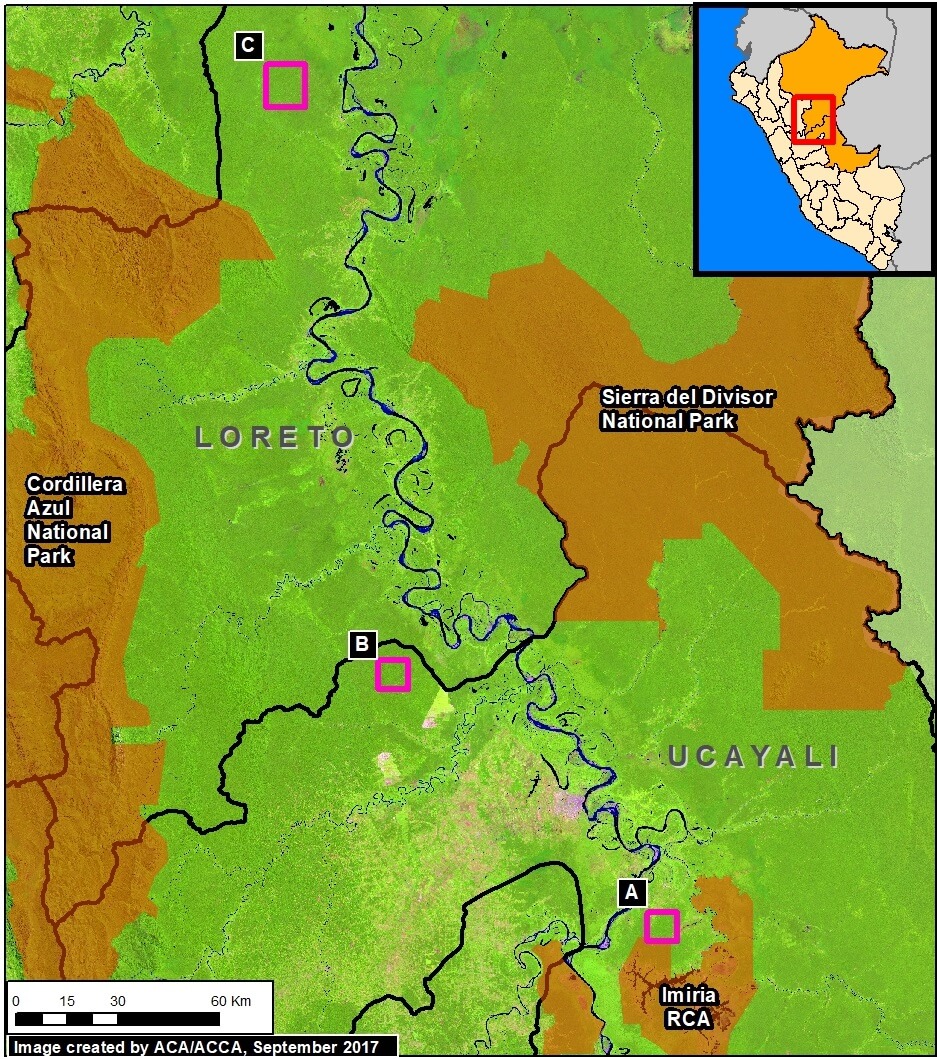
Image 69. Base Map.
Thanks to early warning forest loss alerts (known as GLAD), we recently detected several alarming new deforestation patterns within remote, primary forest of the central Peruvian Amazon.
They appear to be related to medium or large-scale agricultural activities due to their distinct characteristics: straight access paths extending from secondary roads built deep into primary forest, and deforestation of rectangular/square plots.
These patterns are significant because they are very different than the usual patterns observed with small-scale agriculture in the Peruvian Amazon: scattered plots with no major linear features.
Here, we show satellite images of 3 areas in the central Peruvian Amazon (see Base Map) that have recently experienced these alarming patterns, and deserve urgent attention due to the threat of rapid deforestation of large swaths of primary forest.*
MAAP #68: 2017 Deforestation Hotspots in The Peruvian Amazon (Part 2)
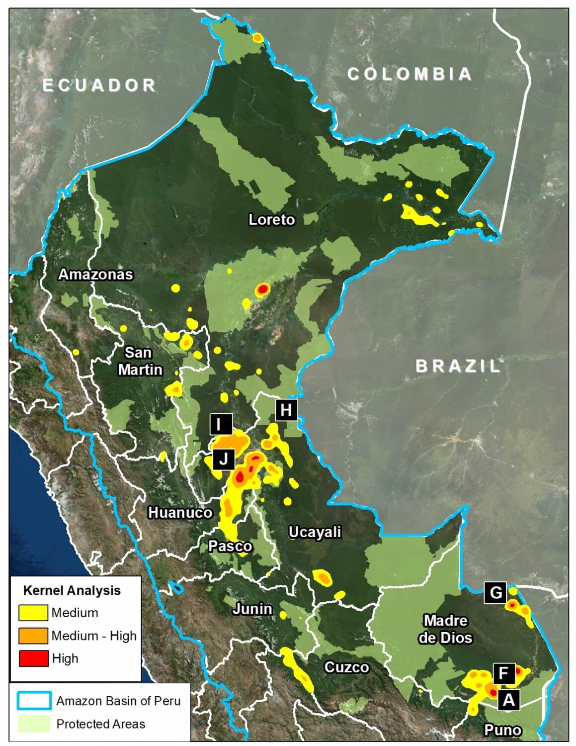
Image 68. Base map. Data: PNCB/MINAM, UMD/GLAD, SERNANP.
In a previous report, MAAP #65, we presented information about deforestation hotspots in 2017 in the Peruvian Amazon, based on early warning alert data from January until mid-July.
Between July and August, the amount of alerts greatly increased, likely due to arrival of the dry season. Thus, this report includes new updated data until mid-August.*
We find new deforestation hotspots in the regions of Madre de Dios and Ucayali (see base map).** At the national level, we now estimate the forest loss of 111,200 acres (45,000 hectares) thus far in 2017 (thru August 17).***
Below, we present satellite imagery of the following hotspots:
– La Pampa, Madre de Dios (Inset A)
– Guacamayo, Madre de Dios (Inset F)
– Iberia, Madre de Dios (Inset G)
– South of Sierra del Divisor, Ucayali (Inset H)
– Nueva Requena, Ucayali (Inset I)
**The data were generated by the National Program of Forest Conservation for Climate Change Mitigation, Peruvian Ministry of Environment (PNCB/MINAM).
**See Hotspots A-E in MAAP #65
***We emphasize that our calculations are just estimates. Official forest loss data are produced annually by the Peruvian Ministry of Environment.
MAAP #66: Satellite Images of Belo Monte Dam Project (Brazil)
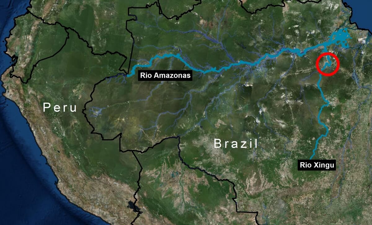
Image 66a. Red circle indicates dam project area.
The Belo Monte hydroelectric dam complex, located on the Xingu River in the state of Para in the eastern Brazilian Amazon (see Image 66a), has been controversial since its inception over 15 years ago, due to both environmental and social concerns related to building and operating one of the largest dams in the world in a sensitive environment.
The dam has recently become operational, providing an opportunity to evaluate initial impacts.
The objective of this article is to present satellite imagery, including a time series from 2011 to 2017, that provides insight into major ecological impacts of the hydroelectric dam project.
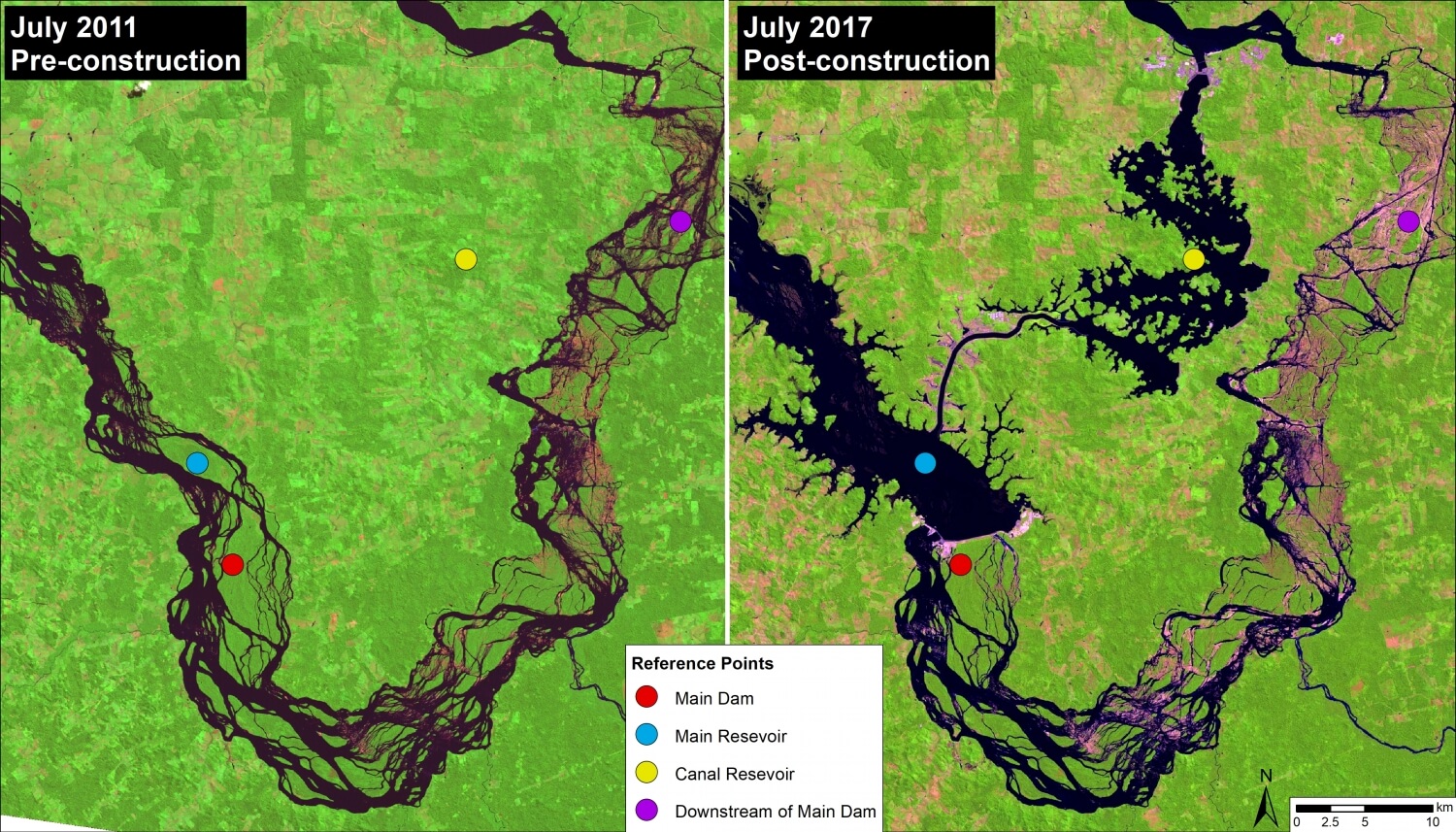
Image 66b. NASA/USGS
Despite legal challenges and strong opposition from impacted indigenous groups, construction of Belo Monte began in 2011 and the first turbines became operational in early 2017. Image 66b shows a direct comparison of before (left panel, July 2011) and after (right panel, July 2017) dam construction.
The dam is in fact a complex: the main dam (red circle) on the Xingu River creates a main reservoir (blue circle); a canal diverts much (up to 80%) of the river’s flow from the main reservoir to the canal reservoir (yellow circle), which feeds the turbines generating the electricity. As a result, downstream of the main dam is left with a much reduced flow (20%) for a stretch of 100 km. This reduced flow stretch, known as the Xingu River’s “Big Bend,” is home to two indigenous peoples (Arara and Juruna). The reference points in the images show these four areas of the complex across time, including before construction.
Peru ranks high (again) in Global Big Day 2017
Once again, Peruvian bird-watching teams (including our own) placed very well during the 2017 Global Big Day that took place on May 13, observing the second-highest number of birds in the world, with 1,338 total species overall. This was just shy of Colombia’s 1,486 bird species but still beat last year’s Peru record of 1,177.
Ornithologist Bob Ridgley raves about birding with Amazon Conservation
Recently, we hosted a distinguished American ornithologist at two of our birding lodges in southeastern Peru. Dr. Robert Ridgely, whose name is synonymous with South American ornithology, was impressed by the “extraordinary habitat” surrounding the lodges, calling the deeply forested transect from Wayqecha Birding Lodge, high in the Andes, down to Villa Carmen Birding Lodge is one of the “the biggest, wildest montane forests” on the planet.
Upcoming birding festivals – will we see you there?
There are many incredible birding festivals taking place in the US every year, and we love meeting new faces every time we attend one! This year, in addition to the Space Coast Birding Festival that we attended in early January, we’ll be sharing the experience of birding with us in the Peruvian Amazon at two upcoming events. If you’ll be in town, make sure to attend and say hello!
A sneak peek at our Los Amigos Birding Lodge
In the 2015 Global Big Day, Los Amigos Birding Lodge registered the fifth highest number of bird species in the world (308) – and with good reason. Not only do we have sharp-eyed bird guides stationed there, but Los Amigos is adjacent to the Los Amigos Conservation Concession and just east of world-famous Manu National Park, which means it is surrounded by millions of acres of protected wilderness.
 Loading...


