
Illegal logging in the Peruvian Amazon is mainly selective and, until now, difficult to detect through satellite information.
In this report, we present the enormous potential of very high resolution satellite imagery (<70 cm) to identify illegal logging.
The leading entities that offer this type of data are Planet (Skysat) and Maxar (Worldview).
We emphasize that this technique has the potential to detect the illegal activity in real time, when preventive action is still possible.
This is an important advance because when an intervention normally occurs, such as detaining a boat or truck with illegal timber, the damage is done.
Below, we show a specific case of using very high resolution satellite imagery to detect and confirm probable illegal logging in the southern Peruvian Amazon (Madre de Dios region).
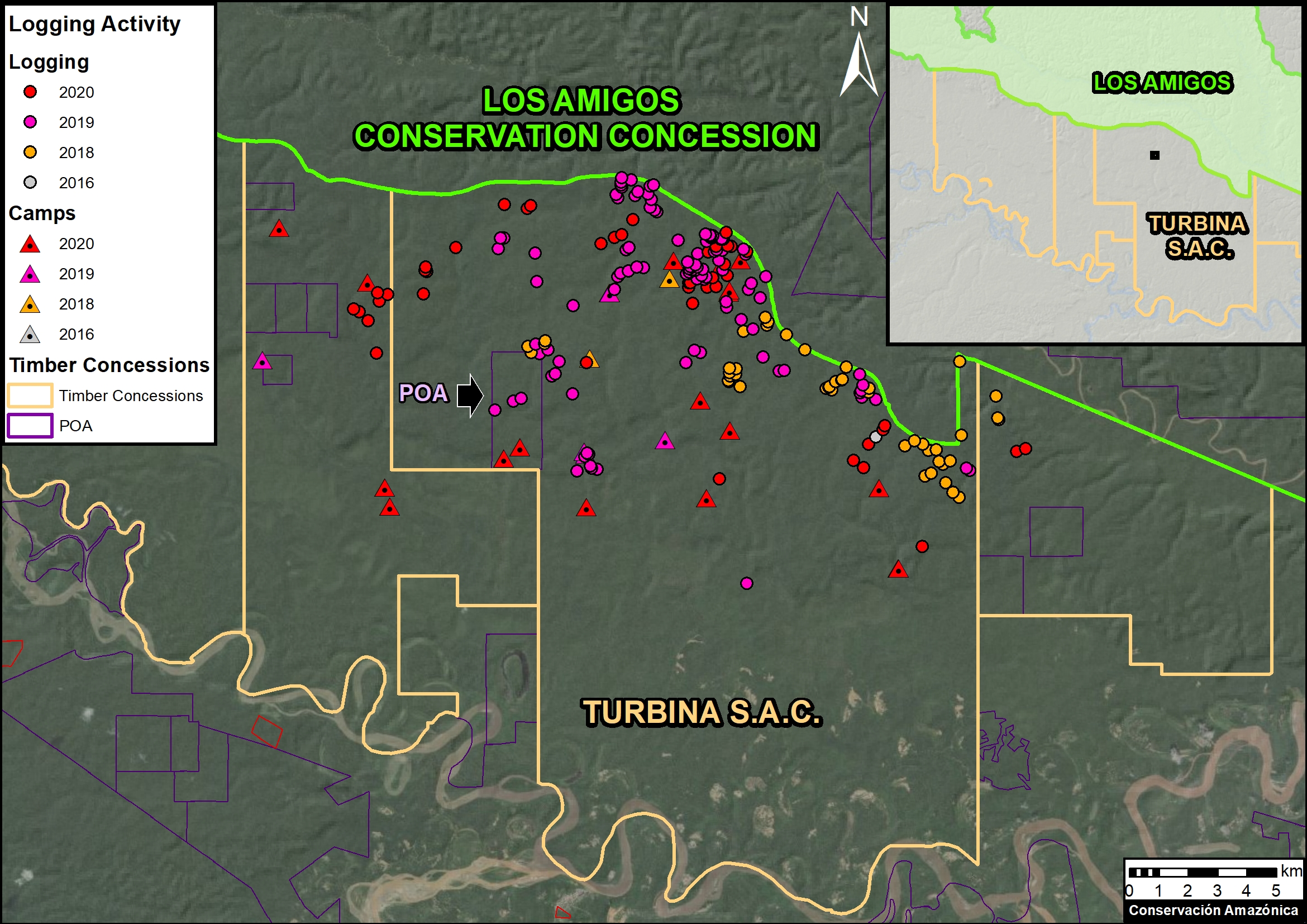
Case: Turbina SAC
The Base Map below shows the intensity of probable illegal logging activity* in the Turbina SAC forestry concession, from 2016 to the present. Specifically, it shows the exact points of illegal logging events (felled trees) and logging camps, as identified through our analysis of very high-resolution satellite images. Note that this forestry concession is adjacent to the Los Amigos Conservation Concession, an important long-term (20 years) biodiversity conservation area.
Very High Resolution Satellite Imagery
Below, we show a series of very high-resolution satellite images, courtesy of the innovative satellite companies Planet and Maxar.
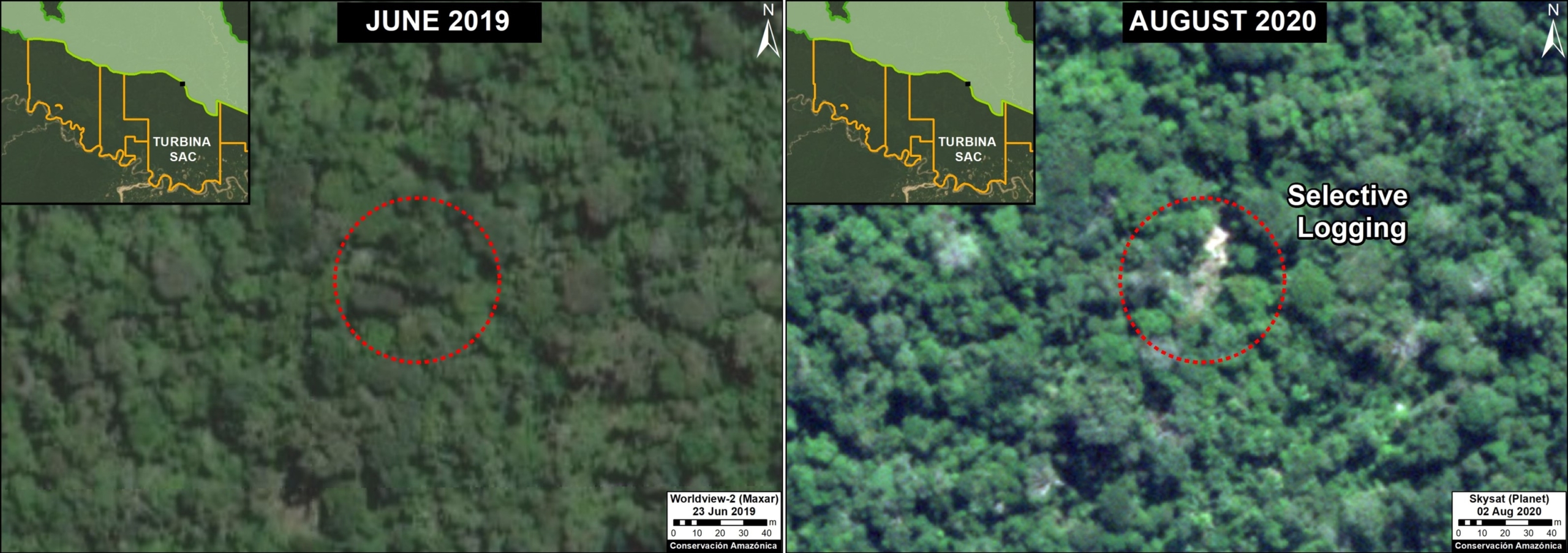
The first image shows the identification of probable illegal logging between June 2019 (left panel) and August 2020 (right panel). The red circle indicates the exact area (canopy) of the illegally logged tree.
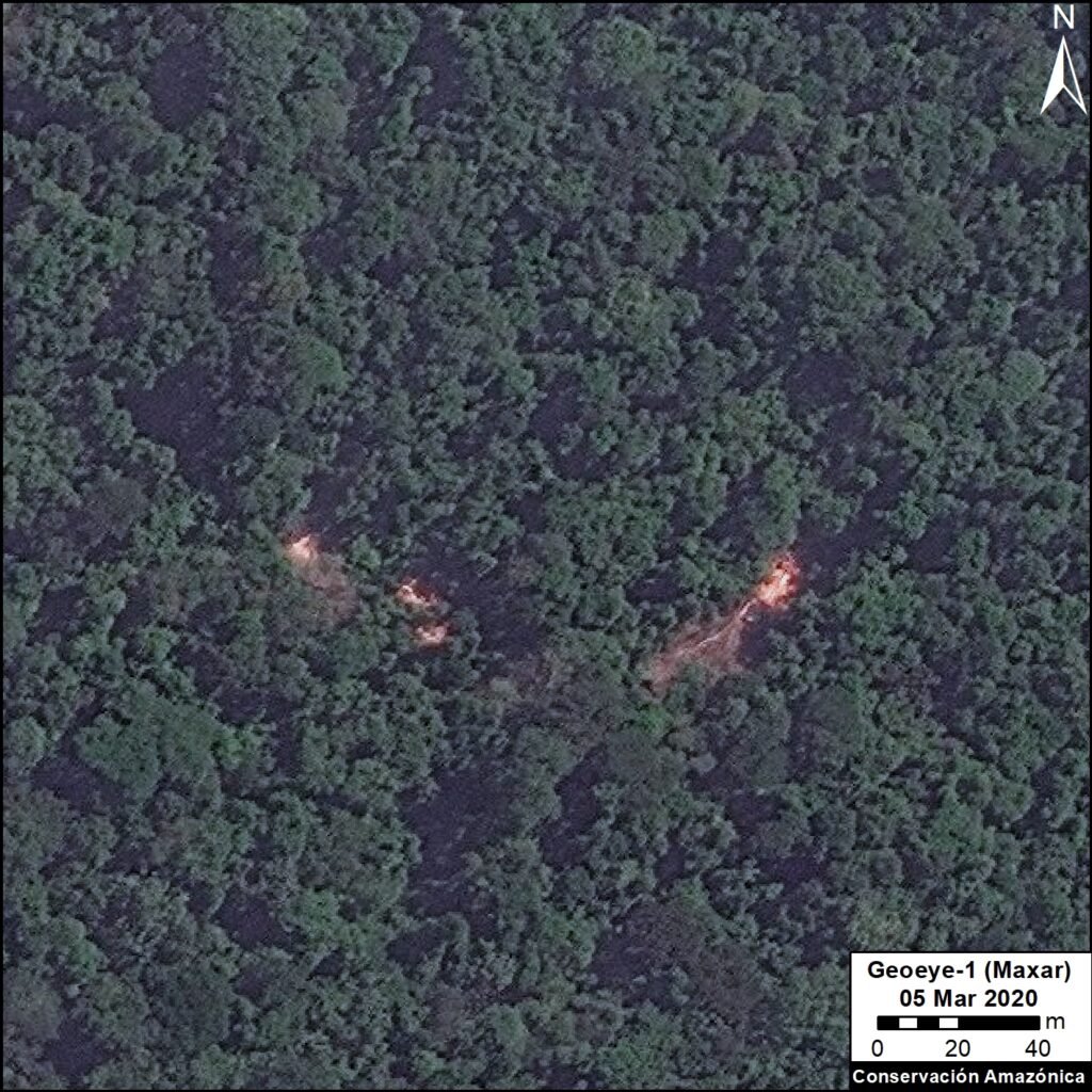
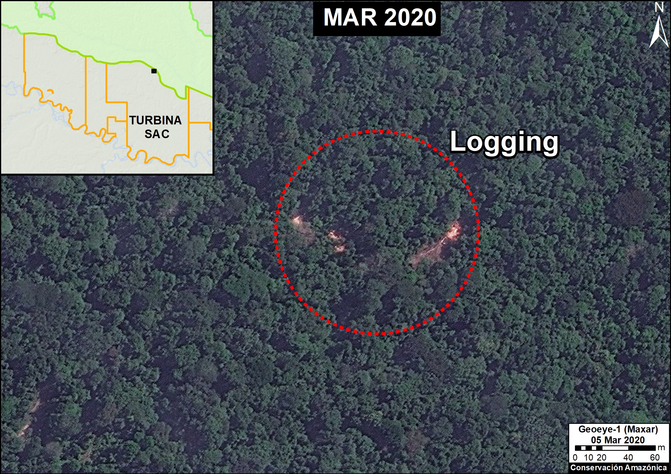
The following image shows the identification of illegal logging in March 2020. The red circle indicates the exact area of the illegally logged trees.
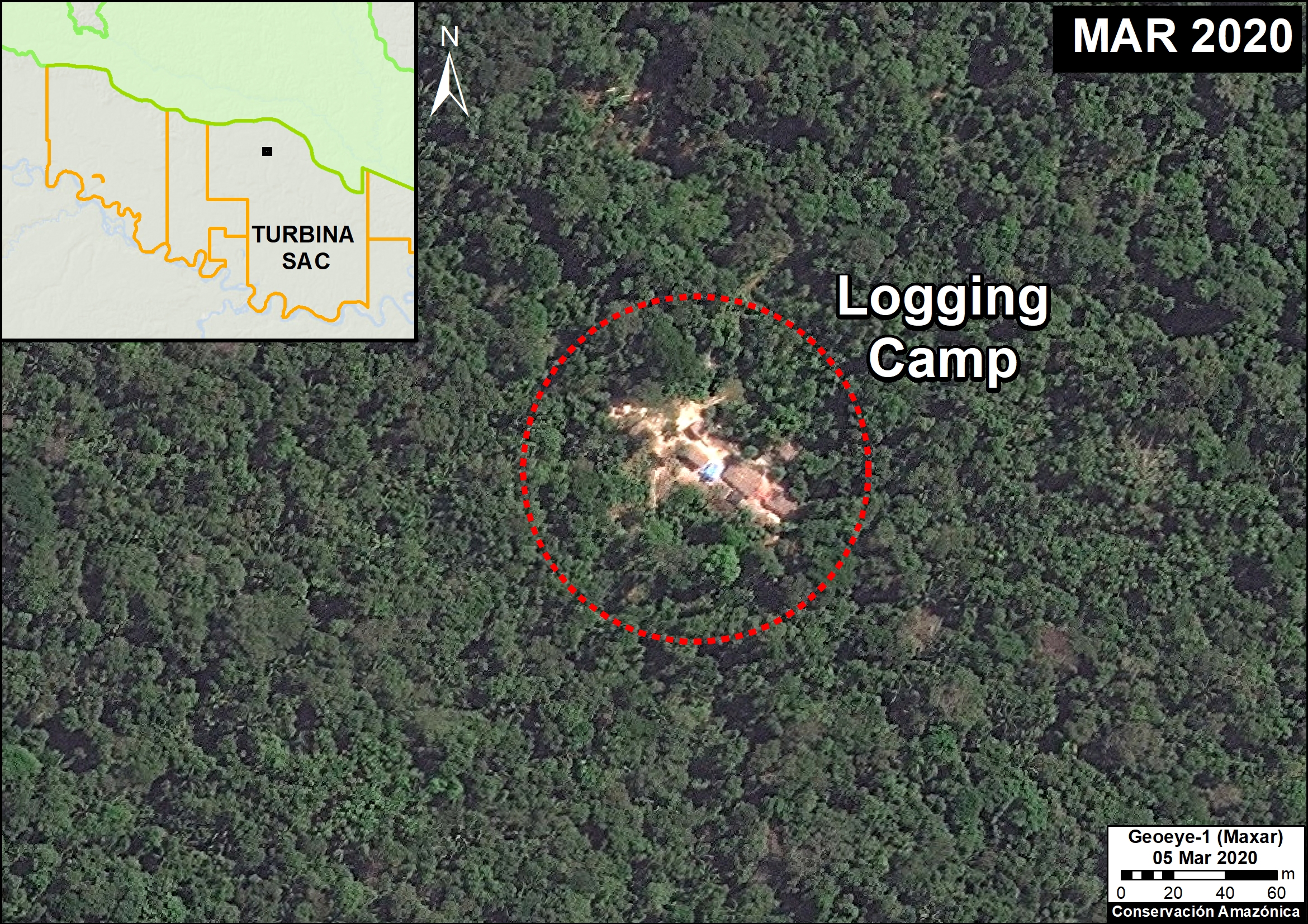
The following image shows the identification of a logging camp in March 2o20. The red circle indicates the area of the camp.
*Statement on Legality
We determined that this logging activity is illegal from a detailed analysis of official information from the Peruvian Government (specifically, the Peruvian Forestry Service, SERFOR, and forestry oversight agency, OSINFOR). This information indicates that, although the concession is in force (Vigente), its status is classified as Inactive (Inactiva). In addition, 2013 was the last year that this concession had an approved logging plan (Plan Operativo de Aprovechamiento, or POA), and it was for a different sector of the concession from the newly detected logging activity.
To confirm our assumption of illegal activity, we requested the technical opinion from the corresponding regional forestry and wildlife authority, however, as of the date of publication of this report, we have not yet received a response.
Thus, with the information we had at the time of publication, we concluded the logging was illegal as it was not conducted within a current management plan.
Methodology
We carried out the analysis in two main steps:
The first step was the visual interpretation and digitization of new logging events and associated logging camps within the Turbina forestry concession. This analysis was based on the evaluation of submetric images obtained from the satellite companies Planet and Maxar, for the period 2019-20. It is worth noting that for Planet, we had the new ability to “task” new images for a specific area, rather than waiting for an image to appear by other means. Logging in the Peruvian Amazon is usually highly selective for high-value species, thus its detection requires a comparative analysis of images (before and after), in such a way that the trees cut during the study period (2019-20 in this case) can be identified.
The second step focused on an analysis of the legality of the identified logging events. The locations of the logged trees and camps were cross-referenced with spatial information on the state and status of forestry concessions provided by the GeoSERFOR (SERFOR) portal, as well as the areas delimited in the annual operational plans of the concessions, verified by OSINFOR and distributed through the SISFOR portal (WMS). We considered both spatial and temporal aspects to the forestry concession data.
Citation
Novoa S, Villa L, Finer M (2020) Detecting Illegal Logging with Very High Resolution Satellites. MAAP: 125.
Acknowledgments
 We thank A. Felix (USAID Prevent), M.E. Gutierrez (ACCA), and G. Palacios for their helpful comments on this report.
This report was conducted with technical assistance from USAID, via the Prevent project. Prevent is an initiative that, over the next 5 years, will work with the Government of Peru, civil society, and the private sector to prevent and combat environmental crimes in Loreto, Ucayali and Madre de Dios, in order to conserve the Peruvian Amazon.
This publication is made possible with the support of the American people through USAID. Its content is the sole responsibility of the authors and does not necessarily reflect the views of USAID or the US government.
 Loading...


