 Ten years ago today, Amazon Conservation launched our novel Monitoring of the Andes Amazon Program (MAAP), a satellite-based monitoring program that began as a tool to pinpoint the most urgent cases of deforestations and fires and has evolved into a game-changing tool for governments, local people, media, civil society, policymakers, and the general public to understand and take action on Amazon-wide issues.
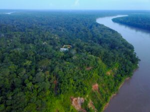
Driven by activities such as illegal mining, logging, and large-scale agriculture, continued deforestation in the Amazon risks intensifying the growing impacts of climate change. Degradation of these forests is pushing the Amazon closer towards its tipping point–a critical point of inflection in which scientists believe that this lush, tropical rainforest may convert to a dry savanna, creating an unstable environment for its biodiverse habitats and ecological productivity. Potential ecological, economic, and social impacts are also heavily influenced by this ecosystem, and understanding its regional and global impacts has become more urgent than ever.
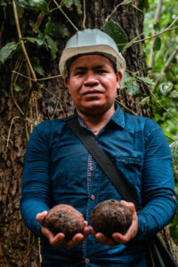
To raise awareness and directly address these threats to the Amazon, we, along with our alliance of sister organizations (Conservación Amazónica-ACCA in Peru and Conservación Amazónica-ACEAA in Bolivia) and a strong partnership network, utilize MAAP to develop a holistic forest governance strategy that can effectively tackle widespread deforestation and fortify the rule of law. Many local and Indigenous communities continue to be most affected by deforestation, and efforts by government agencies to enforce the law and safeguard protected areas and Indigenous territories require timely and effective action. This is where we step in – we’ve become trusted partners of government authorities and agencies to synthesize information on harmful activities, such as illegal mining, logging, and other incursions into Indigenous territories, concessions, and protected areas, into confidential reports, enabling swift action against these illegal activities while the a’re still happening. We have also built similar relationships with local concessionaires and indigenous communities through empowering them to actively protect their productive forests and territories by tracking and reporting illegal actions on their lands.
Over the past decade, MAAP has uncovered key details on the leading causes of deforestation across the Amazon, leading to direct enforcement that has effectively halted harmful and illegal activities. From major media coverage to direct on-the-ground field interventions, we are eager to reflect on MAAP’s history and some of its key moments over the past 10 years.
 The Beginning of MAAP: An Introduction to the Power of Satellite Imagery
Amazon Conservation’s Director of MAAP, Matt Finer, was first introduced to the power of satellite technologies to detect deforestation through a tip from a contact in 2013 who heard rumors of a massive new agriculture project that would deforest thousands of acres in the Loreto region of northern Peru. Finer and his colleague Clinton Jenkins (now at Florida International University) began their hunt for satellite images published by NASA’s Landsat program to determine the validity of the rumors and uncovered visual evidence of deforestation carried out by a palm oil company behind this operation. With the images in hand, Finer was able to piece together deforestation patterns, and his analysis was shared with the local government and made it into the region’s leading news sources. The spread of these images led to a national advocacy campaign carried out by local organizations and an investigation into the company’s suspected unlawful land clearing. Ultimately, the company was fined and forced to stop the deforestation, leading to a massive win for the Amazon. It was this series of events that made Finer realize how satellite imagery could become a transformative tool for forest monitoring and action against illegal deforestation, the groundwork for the early concept of MAAP.
Integrating the Latest Technology
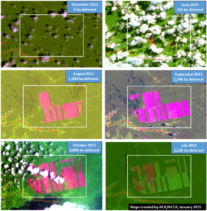
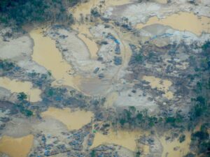
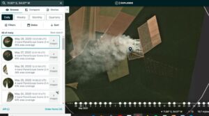
 MAAP was officially launched in the spring of 2015. Our first published MAAP report covered mining activities in the Madre de Dios region of the southern Peruvian Amazon, which were expanding at an alarming rate across an area known as La Pampa outside of the country’s “legal mining corridor” and within the buffer zone of the Tambopata National Reserve. The original maps were based on data from NASA’s Landsat program and analysis via CLASlite.
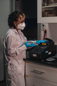
Even during its formative years, MAAP’s quick and thorough analysis of satellite images pinpointing illegal deforestation cases served as an important and trustworthy third-party source of evidence for local authorities and media campaigns. As MAAP became a household name, it continued to innovate by integrating new data sources and evolving satellite, radar, AI, and machine learning technologies into its methodology. Tools such as Planet, Global Forest Watch, University of Maryland – GLAD, NASA – GEDI, Amazon Mining Watch, the Mining Impacts Calculator, and others enabled MAAP to increase the accuracy, timeliness, cost-effectiveness, and geographic reach of its analysis. Furthermore, contributions from our partners continue to feed into our work. For example, our sister organization Conservación Amazónica-ACCA has led the development of the innovative Fire Tracking App, which provides real-time detection and prediction of major fires across the Amazon, as well as other tools to address Peru-specific challenges such as gold mining (through its RAMI tool) and road openings that can lead to illegal logging (Monitoreo de Caminos Forestales newsletter).
Becoming a Trusted Government Partner
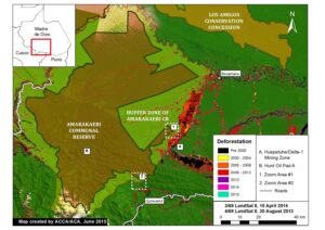 As MAAP began to build regional traction just a few months after its launch, we published a report on the expansion of illegal mining within the Amarakaeri Communal Reserve [an important Peruvian protected area that is co-managed by Indigenous communities and Peru’s National Protected Areas Service (known as SERNANP)], gaining the attention of Peruvian government officials. In the following weeks, SERNANP, armed with our real-time analysis pinpointing instances of illegal deforestation, led the Peruvian government in several field operations to crack down on illegal mining activities in the area. One year after this intervention, our analysis showed no further signs of expansion into the reserve. The internal coordination between MAAP and local government authorities to support these operations laid the groundwork for a close partnership that continues even 10 years later. By sending government agencies like SERNANP confidential intelligence briefs prior to publishing the information publicly, we developed a model where governments have the data, tools, and incentive to take action quickly and to catch perpetrators before they escape. We have since expanded this model across multiple countries across the Amazon, including Bolivia, Ecuador, Colombia, and Brazil.
Driving Action Against Illegal Mining in Peru
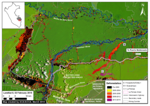
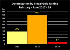 A few years after its founding, MAAP began to gain national attention in Peru as we consistently exposed thousands of acres of illegal deforestation caused by illegal mining activities (in reports such as MAAP #50, #87, and #96). With public pressure for the government to take action growing with each new report, the government launched Operation Mercury in 2019. The operation aimed to stop illegal gold mining in the La Pampa region of the Madre de Dios department, dismantle criminal organizations, and reinforce environmental protection measures. It became one of the largest military and police operations against illegal mining activities in Peruvian history, and a model for intragovernmental coordination. We continued to monitor the situation, and our analysis showed that this operation directly resulted in a major decrease in deforestation at a rate of 92% within just one year.
Around this time, we also began partnering with the Native Federation of the Madre de Dios River Region (FENAMAD), a regional Indigenous federation representing 38 communities from the Madre de Dios region of Peru, to bring them the technology, tools, and legal support needed to protect their ancestral lands. This partnership marked the first time we directly shared our MAAP satellite information with Indigenous communities, which has become a key tool in supporting legal action against illegal incursions into their territories as well as improving their patrolling and defense activities. We continue to work to transfer the technology capacity to FENAMAD to take charge of their territorial protection, and help them drive government operations against illegal deforestation in their territories. The situation in FENAMAD territories and in La Pampa has improved dramatically, but deforestation continues to be a challenge.
In 2023 alone, we supported 5 major government interventions against illegal gold mining in Peru. One of these major interventions took place in June 2023, where the National Police, the Navy, and the Specialized Environmental Prosecutor’s Office of Madre de Dios in Peru carried out a field intervention against illegal mining in the Indigenous community of Barranco Chico thanks to the information provided by MAAP. Roughly $11 million worth of mining tools and equipment were destroyed, making it one of the largest illegal mining raids in Peruvian history.
Helping Decisionmakers Contextualize Deforestation Drivers
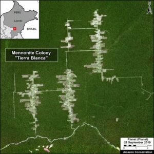 Since the first reported arrival of Mennonites in the Peruvian Amazon in 2017, MAAP has reported their connection to large-scale deforestation caused by their unsustainable and unbridled agricultural practices. Our collective analysis exposed that much of this deforestation was illegal, and by the fall of 2024, these agricultural activities had already destroyed more than 21,000 acres of pristine forest. After the first report on these colonies came out in 2019, MAAP continued to publish information on their expansions, providing key evidence for investigations by local authorities, which has led to several fines for their illegal activities. Mennonite colonies have attempted to expand their agricultural activities to other Amazonian countries, such as Suriname, raising conservationists’ concerns.
Expanding Partnerships Across the Amazon
 Following national success in Peru, MAAP began expanding to the western Amazon, adopting new partners in Ecuador, Venezuela, and Colombia, evolving our ability to provide local authorities with actionable data on deforestation and support legal action against deforestation threats. With their help in diffusing information from shared reports, direct government interventions were carried out against expanding mining activities, clearing mining concessions, and launching further investigations into these perpetrators. In particular, our Ecuadorian partners Fundación EcoCiencia continue to work with us in identifying mining deforestation, which continues to threaten numerous national sites, including protected areas and Indigenous territories, along the Andes-Amazon transition zone (MAAP #206, #221, #219). With their help, the Ecuadorian government carried out a field intervention in January 2022.
With a newfound presence in these countries, MAAP reports began to grow into a key regional tool providing Amazon-wide coverage detailing deforestation trends, the Amazon’s tipping point, and cutting-edge carbon stats across all nine Amazonian countries. Recently, one of our Amazon-wide MAAP reports revealed that Amazon contains 56.8 billion metric tons of aboveground carbon and is now teetering between a carbon source and sink. This is a crucial turning point for connecting key pieces of regional deforestation metrics at a larger scale. Today, we have strategic partnerships with local organizations in each Amazonian country to further emphasize the interconnectedness of regional deforestation impacts and to help diffuse MAAP information as a call to action.
Leveraging Public Support through Media Presence
 In 2021, MAAP made major headlines across multiple US news outlets when deforestation data from our reports sparked conversations on climate impacts, Indigenous rights, carbon emissions, and more. Regional issues in the Amazon were shifting to become global matters, and the importance of protecting this ecosystem became even more urgent. In some cases, MAAP’s growing media presence in the US also began to influence national governments, encouraging more direct and effective conservation efforts in the Amazon.
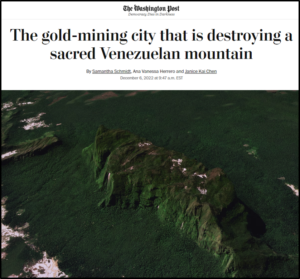
Most notably, in December 2022, the Washington Post published an article highlighting a MAAP report about illegal mining on top of a sacred tepui in the heart of Yapacana National Park in the Venezuelan Amazon (MAAP #169). In response, the Venezuelan government conducted a military operation against the illegal mining activity on the tepui that dismantled illegal mining camps and equipment.
In April 2024, we published a MAAP report in collaboration with SOS Orinoco that contained satellite images from atop the tepui following this intervention, revealing that all illegal mining camps and equipment on top of the tepui have been effectively cleared. All 425 illegal mining camps and heavy equipment visible in December 2022 fell to zero in January 2024. This marked a major victory for Amazon Conservation in Venezuela, keeping Indigenous landmarks and natural parks safe and protected.
Halting a Massive Deforestation Project in Suriname
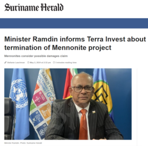 Following the publication of an article by the environmental news outlet Mongabay, a review of official documents from the government of Suriname detailed a concerning proposed land deal that would clear large tracts of Amazon rainforest for agriculture. In response, we published a MAAP report that analyzed the drastic impacts of this wide-scale deforestation project, providing local partners with key data. At the end of 2024, this information eventually reached the Surinamese government, and following the publication of this MAAP report, they officially announced the rejection of this project that would have destroyed over 1 million acres of forests.
From our humble beginnings in the southwestern Amazon of Peru, we’ve expanded MAAP’s scope across the entire Amazon basin, shaping us into a leading science-based conservation organization aiding in the critical survival of the greatest wild forest on Earth. To those who have supported our real-time monitoring work, thank you for all you have done! We can only hope you are as proud as we are of all we’ve been able to accomplish for the Amazon together.
Acknowledgments
We are extremely proud of our dedicated MAAP team, who have worked incredibly hard to deliver actionable information on deforestation and consolidate a reputable network of partners across the Amazon. We are also grateful to all of the researchers, specialists, and scientists for their time and contributions.
We are also incredibly thankful for the continued collaboration and contributions of our local partners:


We also thank our key data and technical partners:
And our generous supporters over the years, for their investment in our mission and work:

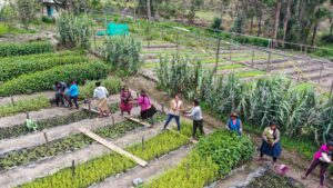
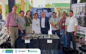 Last week, staff members from our Alliance, comprised of Amazon Conservation, Conservación Amazónica – ACCA, and Conservación Amazónica – ACEAA attended the 15th Annual meeting of the Governors’ Climate & Forests Task Force (GCF Task Force) in Rio Branco, Acre, Brazil. The event this year set up essential discussions regarding the co-construction of a New Forest Economy that strengthens forest protection, supports land restoration, and fosters sustainable economic growth and job opportunities across the region.
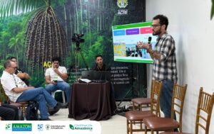 This year’s annual meeting marked an important step forward for Amazon Conservation, as our Alliance hosted a special side event called “People at the Center of Bioeconomic Transitions: Uniting Small Producers, Indigenous Peoples, and Local Communities,” to share progress updates on the development of the bioeconomy and facilitate dialogues between local producers in the Madre de Dios (Peru), Acre (Brazil), and Pando (Bolivia) regions of the Amazon. “My family lives inside the Chico Mendes Reserve here in Acre. Mother Nature feeds us, so we must treat her with care. What we need now are credit lines that actually reach our cooperatives. We discussed that capital is one of the missing pieces for communities like ours”, emphasized Vanusa Ferreira, one of the leaders at Chico Mendes Extractive Reserve.
 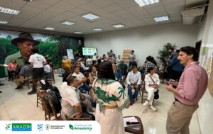 The exchange of experiences among producers of these countries sparked fresh hope and a collaborative spirit grounded in shared missions. As Manoel de Jesus, President of the Chico Mendes Extractive Reserve Association, said, “We’re going home energized. The proposals shaped here, together with partners from Peru, Bolivia, and beyond, show that when we stand united, we have a bright future.”
 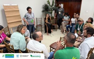 Marcos Terán, Executive Director of Conservación Amazónica – ACEAA in Bolivia, added that “bringing producers from Peru and Bolivia to share lessons in Brazil charts a common road toward a forest-based bioeconomy. The southwestern Amazon is not just productive land, it’s a climate engine. Solutions must start with local actors to get them scaled up.”
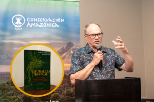 Last week, Amazon Conservation Co-Founder Dr. Adrian Forsyth joined our Peruvian sister organization,
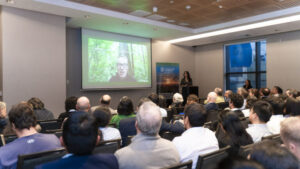 The event “An Afternoon For Conservation with Adrian Forsyth,” hosted in Lima, Peru, celebrated the official launch of
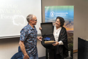
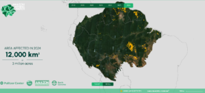 As
As 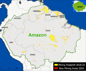 This report highlights several major findings:
 Earlier this month, our

 If you’ve been following us on our
 Beginning of Our Flagship Brazil Nuts Conservation Program
  Los Amigos Conservation Concession Created
 Our First Biological Station Established
 Expanded our Work on the Ground to Bolivia
 Wayqecha Cloud Forest Biological Station Established
 Manu Biological Station Established
 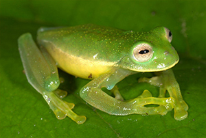 Discovered the 7,000th Frog
  Started to Promote New Forest-Friendly Livelihoods
 Planted 250,000 Trees to Date
 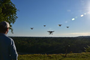 Inaugurated the Southwest Amazon Drone Center
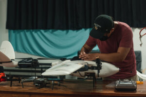
 Invented Novel Fire Tracking App
 Devised the Amazonian Fruit Observatory
  Planted over 750,000 Trees
 Reached 10.5 million Acres of Protected Forests
 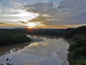 Grew Real-time Monitoring Technology and Action to Wider Amazon – 2025
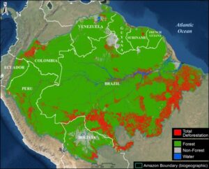

 Loading...


