
University of British Columbia PhD candidate Micah Scholer has visited Peru enough times to know the lay of the land and discover some of the incredible birds the country has to offer. Read about how he got into birding, the research project he is conducting in the Amazon, and some of his adventures in the field.
Author: dcadmin
MAAP #54: Natural Forest Loss Due To “Hurricane Winds” in the Peruvian Amazon
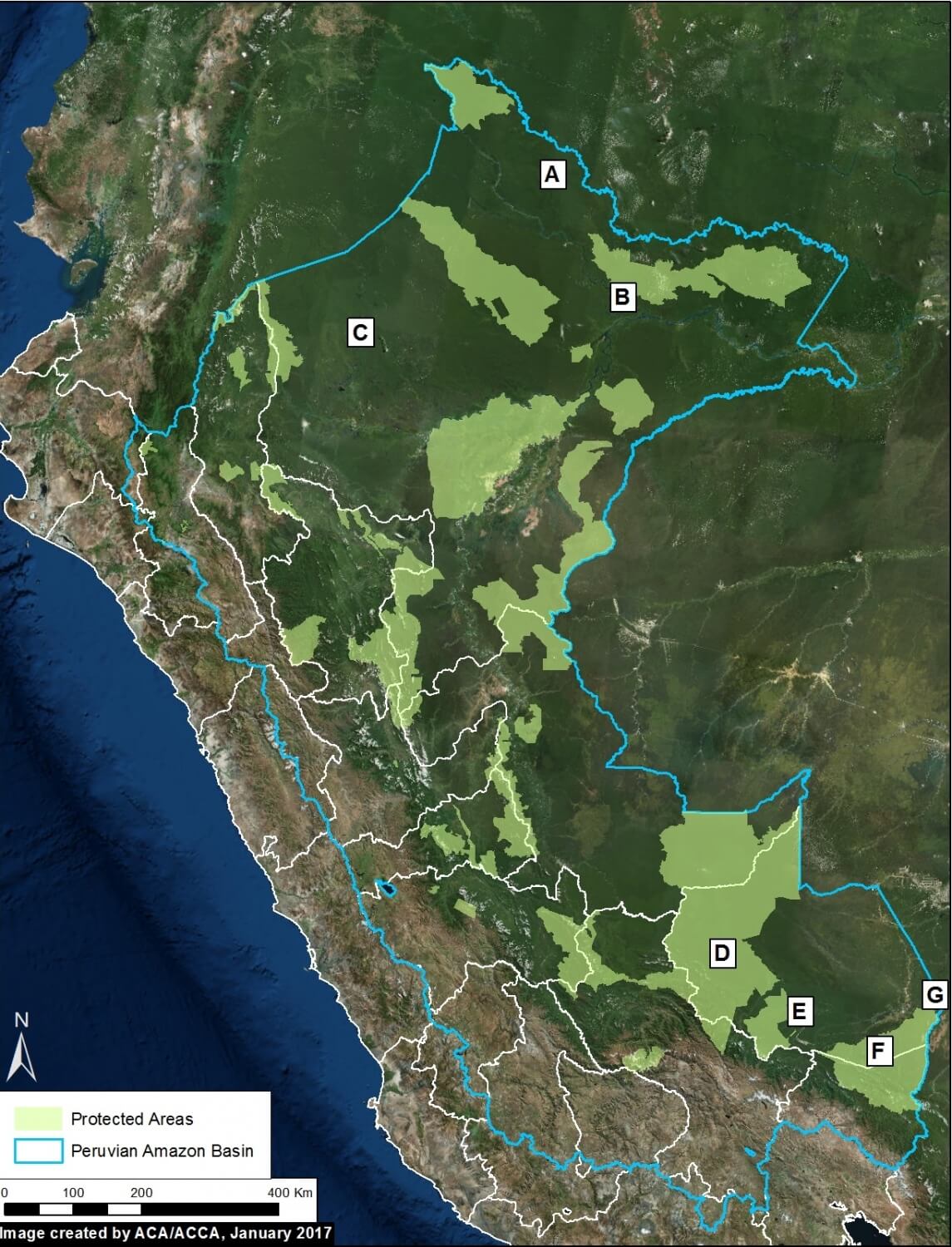
Image 54. Base Map
A little-known, but not uncommon, type of natural forest loss in the Peruvian Amazon is blowdown due to strong winds from localized storms (locally known as “hurricane winds”).
The intense winds cause a chain reaction of fallen trees, resulting in a fan-shaped pattern of forest loss with a defined orientation following the direction of the storm winds.
This phenomenon has previously been reported in Brazil and Colombia (see References below).
The base image (Image 54) shows the location of some recent (during 2016) examples of forest loss due to blowdowns in the Peruvian Amazon.
These examples were initially detected from analysis of GLAD alerts, early warning tree loss data produced by the University of Maryland (see Annex).
Below, we detail the 7 blowdown examples indicated on the base map. They are located in both northern (Loreto region) and southern (Madre de Dios region) Peru, and include 4 Protected Areas. The forest loss in these examples ranged from 24 to 900 hectares.
MAAP Synthesis #2: Patterns and Drivers of Deforestation in the Peruvian Amazon
We present our second synthesis report, building off our first report published in September 2015. This synthesis is largely based on the 50 MAAP reports published between April 2015 and November 2016. The objective is to synthesize all the information to date regarding deforestation trends, patterns and drivers in the Peruvian Amazon.
MAAP methodology includes 4 major components: Forest loss detection, Prioritize big data, Identify deforestation drivers, and Publish user-friendly reports. See Methodology section below for more details.
Our major findings include:
- Trends. During the 15 years between 2001 and 2015, around 4,448,000 acres (1,800,000 hectares) of Peruvian Amazon forest has been cleared, with a steadily increasing trend. 2014 had the highest annual forest loss on record (438,775 acres), followed by a slight decrease in 2015. The preliminary estimate for 2016 indicates that forest loss remains relatively high. The vast majority (80%) of forest loss events in the Peruvian Amazon are small-scale (<5 hectares), while large-scale events (> 50 hectares) pose a latent threat due to new agro-industrial projects.
- Hotspots. We have identified at least 8 major deforestation hotspots. The most intense hotspots are located in the central Amazon (Huánuco and Ucayali). Other important hotspots are located in Madre de Dios and San Martin. Two protected areas (Tambopata National Reserve and El Sira Communal Reserve) are threatened by these hotspots.
- Drivers. We present an initial deforestation drivers map for the Peruvian Amazon. Analyzing high-resolution satellite imagery, we have documented six major drivers of deforestation and degradation: small/medium-scale agriculture, large-scale agriculture, cattle pasture, gold mining, illegal coca cultivation, and roads. Small-scale agriculture and cattle pasture are likely the most dominant drivers overall. Gold mining is a major driver in southern Peru. Large-scale agriculture and major new roads are latent threats. Logging roads are likely a major source of forest degradation in central Peru.
MAAP #53: Wildfire Hotspots in The Peruvian Amazon In 2016
During 2016, Peru experienced an intense wildfire season, exacerbated by widespread drought conditions across the country.
The base map (Image 53, to the left) shows the 2016 fire alert hotspots.
These alerts are generated from a moderate-resolution (375 meters) satellite sensor (VIIRS) that detects significant new heat sources.
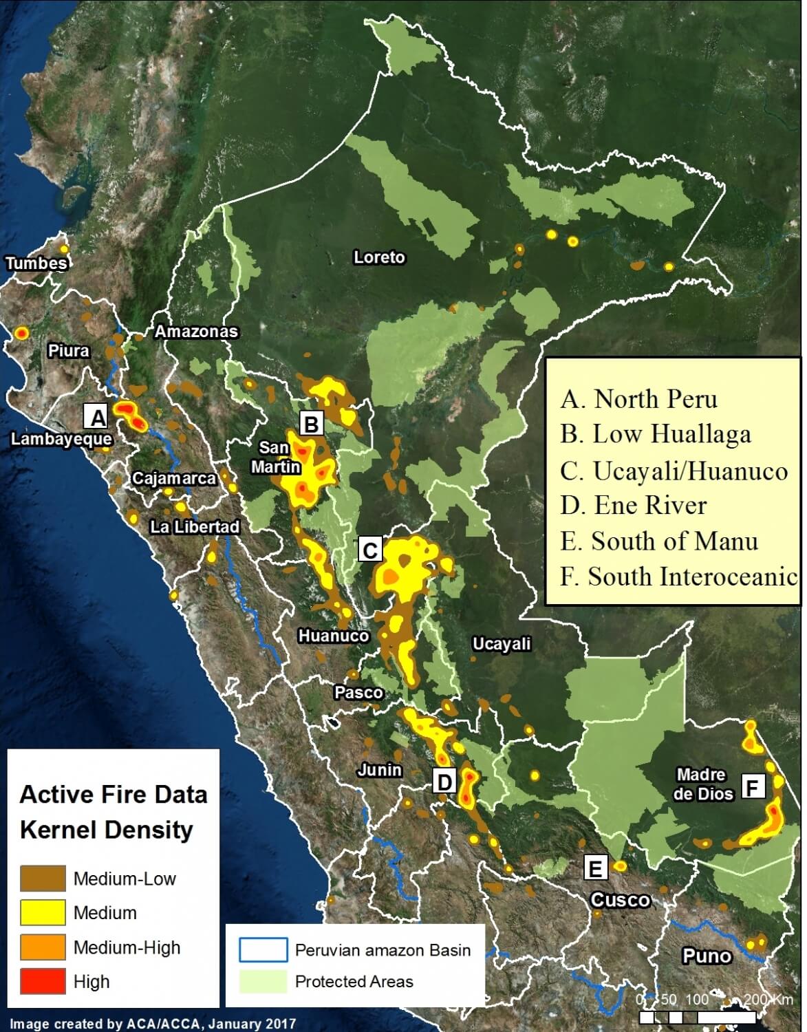
Image 53a. VIIRS/NASA, SERNANP.
Although there has not yet been a comprehensive evaluation of the causes of these fires, evidence indicates that many are linked to agricultural practices that allow fires to escape to surrounding natural habitats.
In the image, we highlight 5 significant fire hotspots in the Amazon basin, labeled A-E (A. Northern Peru; B. Lower Huallaga; C. Huánuco/Ucayali, D. Ene River, E. Southern Manu, F. Interoceanic Highway).
These areas are described in more detail below.
MAAP #52: Update – Fires Degrade 11 Protected Areas in Northern Peru
In the previous MAAP #51, we gave an initial impact assessment regarding the recent wave of fires in protected areas in northern Peru. Here, we provide a more comprehensive update.
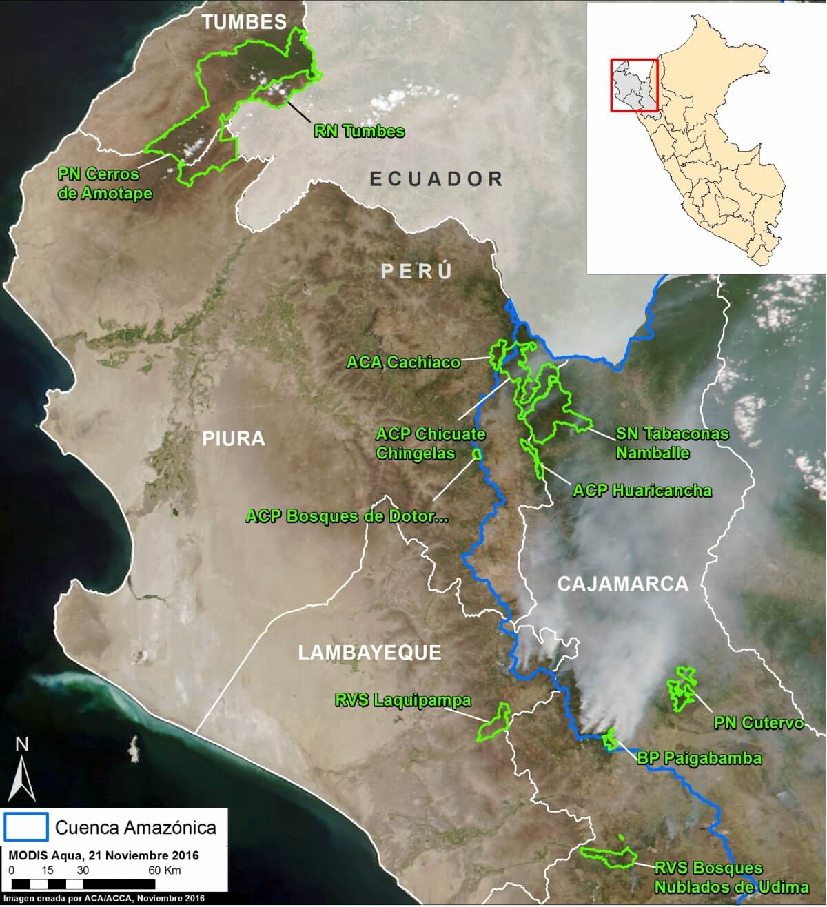
Image 52a. Data: MODIS/NASA, SERNANP, NCI.
Our revised estimate is 6,594 acres (2,668 hectares) burned in 11 Protected Areas (see Image 52a) in late 2016. Note that the image is from November and smoke from the fires is clearly seen.
The majority (4,165 acres) occured in 7 national protected areas under national administration (Cutervo National Park, Pagaibamba Protected Forest, Laquipampa Wildlife Refuge, Tumbes National Reserve, Cerros de Amotape National Park, Tabaconas-Namballe National Sanctuary, Udima Wildlife Refuge).*
The estimates refer to areas directly affected by fires (i.e. burned) and come from two sources: our analysis of satellite images and field information from SERNANP, the Peruvian protected areas agency.
It appears that the primary cause of these fires is poor agricultural burning practices during a time of intense drought. These conditions allowed fires to escape into protected areas.
Below, we show a series of new satellite images of some of the burn areas (for images of other areas, see MAAP #51). We also publish a statement from SERNANP.
*The rest occured in 3 national protected areas under private administration (Chicuate-Chinguelas, Huaricancha, and Bosques de Dotor Private Conservation Areas; 1,927 acres) and 1 municipal protected area (ACA Cachiaco-San Pablo; 502 acres).
MAAP #51: Fires Degrade 7 Protected Areas in Northern Peru
Peru’s intense 2016 fire season continues, most recently hitting the northern part of the country.
As seen in this map on the left, during November 2016 the highest concentration of fire alerts (as detected by the VIIRS satellite sensor) were concentrated in the headwaters of the northern Amazon basin (departments of Cajamarca, Piura, and Lambayeque).
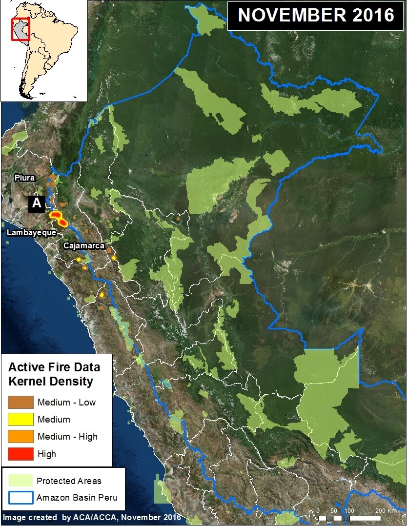
Image 51a. Data: VIIRS/INPE, SERNANP.
It appears that the primary cause of these fires is poor agricultural burning practices during a time of intense drought. These conditions allowed fires to escape into protected areas, including 6 national-level protected areas and 1 municipal protected area.
Until additional cloud-free satellite images are available it is difficult to quantify the total burned area. However, by analyzing the currently available imagery, we estimate 1,980 acres burned in 3 of the protected areas (Laquipampa Wildlife Refuge, Chicuate-Chinguelas PCA, and Cachiaco-San Pablo PCA). The Peruvian protected areas agency, SERNANP, estimates an additional 1,000 acres burned in the Pagaibamba Protected Forest. In addition, by analyzing fire alert data, we estimate that an additional 890 acres affected in the other 3 protected areas (Cutervo National Park, Tabaconas Namballe National Sanctuary, and Huaricancha PCA. See below for details.
Moreover, the Peruvian civil society organization SPDA is highlighting that one of the main problems is the lack of fire-related planning by the Peruvian government, which since 2001 has not fulfilled its mandate to create a National System of Fire Prevention and Control.
Amazon Conservation hosts course on neotropical birds
Amazon Conservation held its second course on ecology, taxonomy and conservation of neotropical birds at our Los Amigos Biological Station in Peru earlier in September. The course was held for Peruvians in conjunction with, the Arequipa Museum of Natural History (MUSA) and the Center for Ornithology and Biodiversity (CORBIDI). The purpose of bringing together these organizations was to continue our goal of training the next generation of Peruvian ornithologists to grow bird conservation and awareness in the country.
My unforgettable birding trip to the Peruvian Amazon
Birds and wildlife, that’s what I was hoping to see on my journey to the tropical rainforest in southeastern Peru with conservationists from Amazon Conservation. Our destination was Amazon Conservation’s Los Amigos lodge and research station, part of a pristine 350,000 acre conservation concession area bordering the iconic Manu National Park. Traveling to the lodge on a lovely four hour boat ride up the Madre de Dios river set the tone for our adventure. We scanned the river banks and were rewarded with jabirus, horned screamers, wood storks and black hawk-eagles in flight, pied lapwings and large-billed terns on sandbanks, a collared peccary swimming across the river and a large capybara by the shoreline. Mining activity was also present along the river, a stark reminder of the importance of protecting habitat.
Get to know our bird guide extraordinaire: Q&A with Percy Avendaño
When you’re in the middle of the Amazon rainforest it’s essential to count on a trusted guide to help you see all the hidden treasures that you might be missing. Meet Percy Avendaño, our staff naturalist and birding guide. He has experience guiding expert-level birders and casual naturalists alike, and our visitors rave about his knowledge of birds and nature, his friendliness and resourcefulness.Percy is also a Top eBirder, ranking second in the world for 2016’s Global Big Day, with 257 species spotted at our Villa Carmen lodge. Learn about how he came to work with Amazon Conservation, what the birding industry is like in Peru and what a birding adventure might look like with Percy as your guide!
MAAP #50: Gold Mining Deforests 31,000 Acres in Southern Peruvian Amazon During Last 4 Years
We analyzed hundreds of high-resolution satellite images to calculate the amount of recent (October 2012 – October 2016) gold mining deforestation in the southern Peruvian Amazon: 30,895 acres. Combining this finding with previous studies, we estimate the total gold mining deforestation of around 154,440 acres in the region. Image 50a shows the recent gold mining deforestation in red, and all previous gold mining deforestation in yellow.
Key findings include:
- The vast majority of the deforestation has occurred in the Madre de Dios region, but also has extended to the adjacent regions of Cusco and Puno.
- The rate of recent gold mining deforestation was much lower (42%) than during its peak, which occurred between 2010 and 2012 (6,640 vs. 15,650 acres/year).
- However, half of the recent gold mining deforestation (15,830 acres) occurred within the buffer zones of three protected areas (Tambopata National Reserve, Bahuaja Sonene National Park, and Amarakeari Communal Reserve).
- Moreover, recent gold mining deforestation invaded two protected areas (Tambopata and Amarakaeri).

Image 50a. Data: MAAP, Asner et al (2013) PNAS, SERNANP. Click to enlarge.
Previously, Dr. Greg Asner and colleagues documented the deforestation of approximately 123,200 acres (50,000 hectares) by gold mining activities in the southern Peruvian Amazon through September 2012 (Asner et al 2013). We have updated this information by analyzing hundreds of recent (2016) high-resolution satellite images (see Methodology section below). We documented an additional 30,895 acres (12,503 hectares) of gold mining deforestation between October 2012 and October 2016. Thus, combining both studies, we estimate the total gold mining deforestation of around 154,440 acres (62,500 hectares).
 Loading...


