Establishing Bolivia’s Largest Conservation Area

Supporting  local government and communities to protect 3.7 million acres of pristine forests, savannas, and wetlands.

Photo of Bajo Madidi

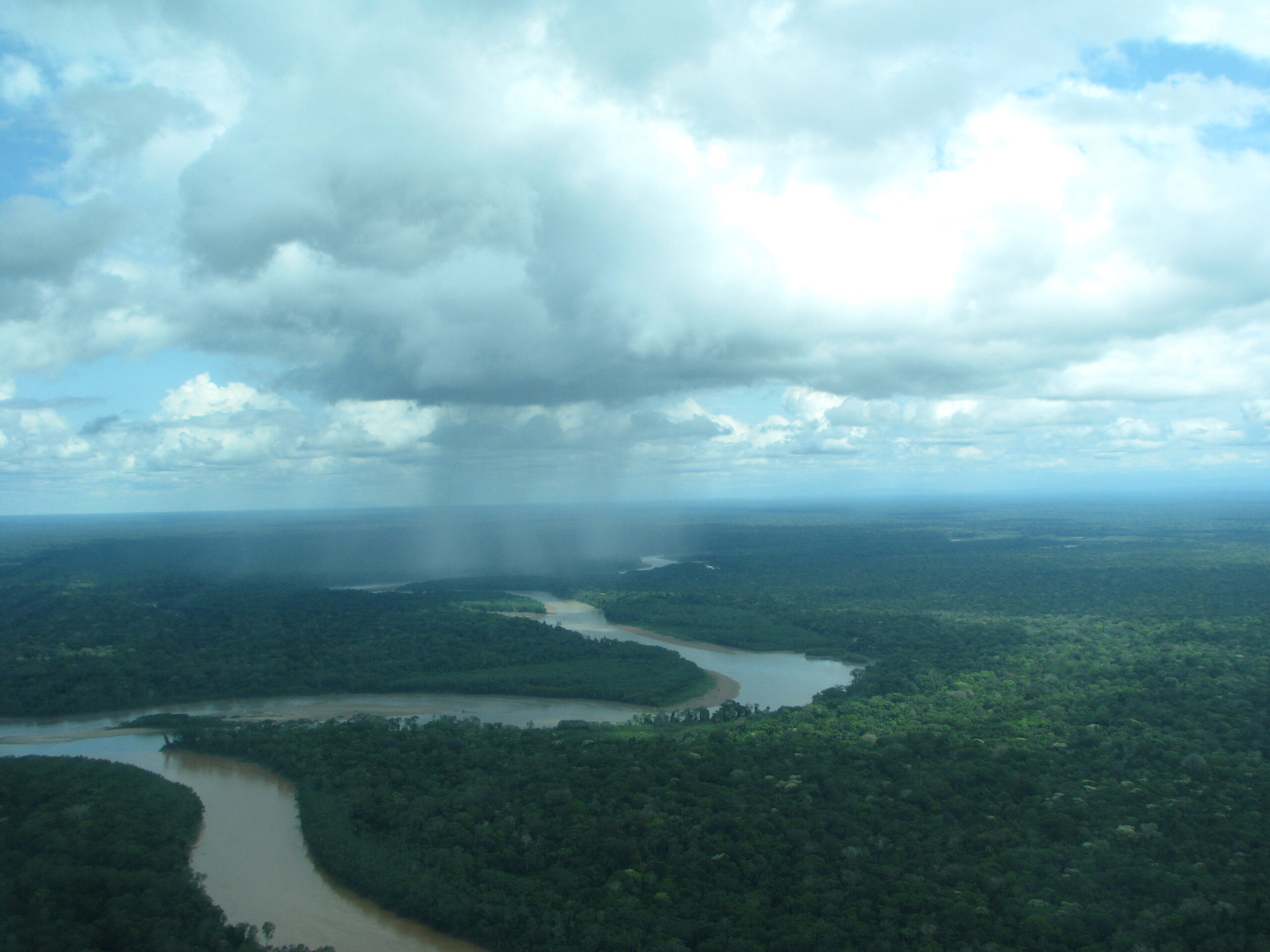
In 2019, we helped the local government of Ixiamas, Bolivia establish the Municipal Conservation Area of Bajo Madidi, an area spanning 3.7 million acres (1.5 million hectares). Three times the size of the Grand Canyon, this conservation area is the largest in Bolivia and one of the largest in the world. It hosts a variety of ecological landscapes including wetlands, lowland rainforests, and savannas.


Photo of Bolivia: Marsh deer
Marsh deer

Throughout the long and complex creation process, we provided the technical expertise and assistance to both the government and local communities that was needed to officially declare the area. We also helped them gather and understand key environmental data on the conservation needs of this landscape to develop the plan to protect it for the long-term. This conservation plan now guides the sustainable use and management of natural resources in Bajo Madidi.

Photo of Orinoco Goose
Orinoco goose

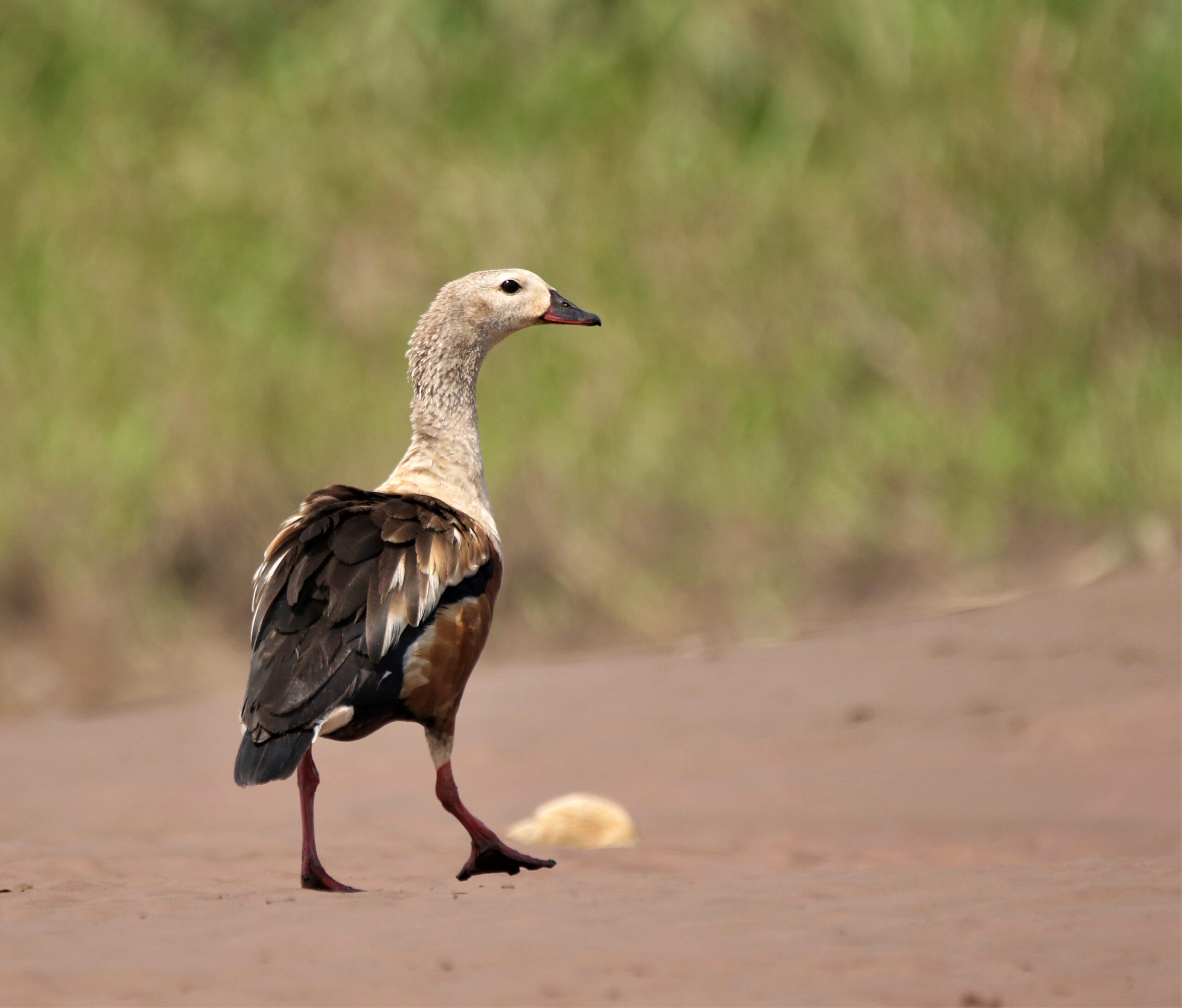
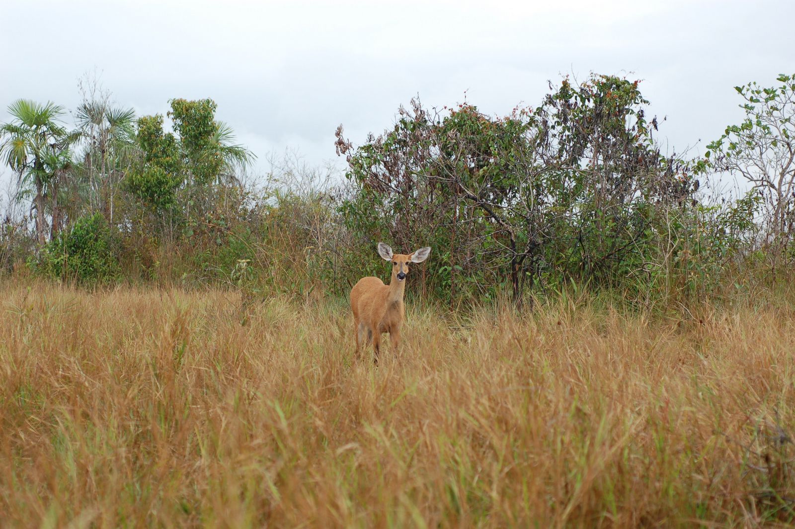
This area’s value lies in its major biological significance. While many savannas in Bolivia have been transformed by cattle ranching or road construction, the savannas within Bajo Madidi remain some of the most ecologically-intact savannas in the world. They are home to more than 20 endangered species such as the maned wolf, Orinoco goose, marsh deer, black-faced spider monkey, and the giant anteater, all categorized as “vulnerable” or “threatened” on the IUCN Red List of Threatened Species.


The protected area will also protect the six rivers that flow through Bajo Madidi, safeguarding critical watersheds and aiding migration of birds, fish, and other animals that contribute to the overall rainforest health. Additionally, it will help maintain local The Madre de Dios River at sunset. 
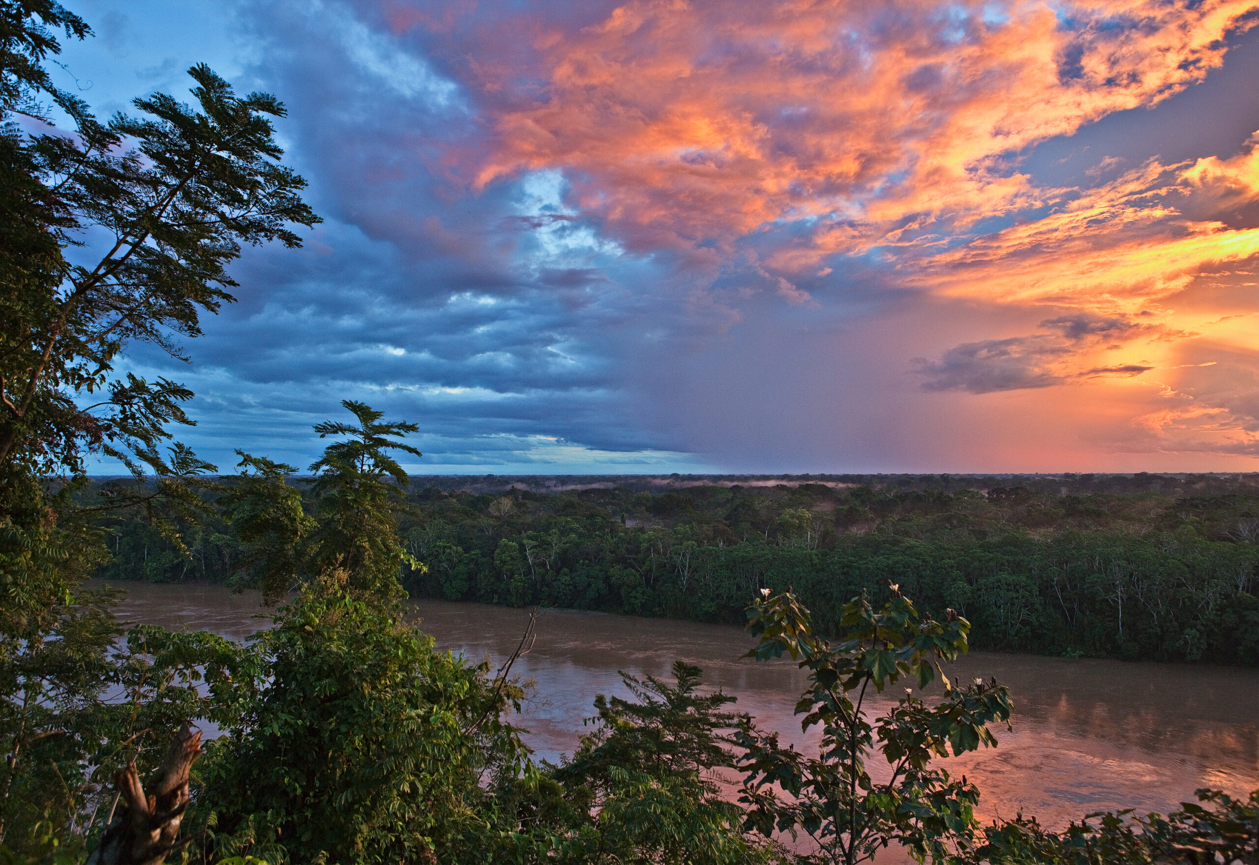
communities’ sustainable harvesting of herbs, fruits, and nuts. This forest alone contains nearly 10% of the world’s Brazil nut trees under production. It also connects nearby nature reserves, creating an important biodiversity corridor of protected lands in the region.

The establishment of this area was a massive undertaking with contributions by local peoples and support from over 800 stakeholders. Successes like these are the foundation of our conservation efforts that have helped protect over 8.3 million acres of forests to date. 

This was a story from our 2019 Impact Report. Click here to read about other conservation successes from 2019.

Amazon Fire Tracker 2020: End Of August Update (Over 600 Major Fires)

August 2020 just ended its run as a severe Amazon fire month.

Brazilian Amazon Major Fire #584, August 2020. Data: Planet. Analysis: MAAP.Our novel Real-time Amazon Fire Monitoring app has detected 646 major fires in the Brazilian Amazon thus far in 2020.*

Of these, 88% (569 major fires) occurred in August,* and all were illegal, occuring after the burning moratoriums established in July.

Also in August, we saw the sudden appearance of “Forest Fires,” defined here as human-caused fires in standing forest. We detected 82 forest fires in August, which now account for 13% of all the major fires.*

The vast majority of the major fires (79%) continue to burn recently deforested areas, defined here as areas where the forest was previously and recently cleared (between 2018-20) prior to burning.

In fact, over 1.1 million acres (453,000 hectares) of recently deforested areas has burned in 2020. Thus, the fires are actually a smoking indicator of the current rampant deforestation in the Brazilian Amazon.

Base Map

The Base Map is a screen shot of the app’s “Major Amazon Fires 2020” layer (as of September 1). The majority of the major fires in the Brazilian Amazon have been in the states of Pará (37%) and Amazonas (33%), followed by Mato Grosso (16%), Rondônia (13%), and Acre (1%).

The app has detected an additional 58 major fires in the Bolivian Amazon thus far in 2020. The majority of these (71%) have occured in savanna ecosystems in the department of Beni.

Screen shot of the app’s “Major Amazon Fires 2020” layer (as of September 1).

*Notes and Methodology

Data updated as of September 1, starting from the first major fire detected on May 28.

We detected 569 major fires during August in the Brazilian Amazon.

Prior to August, we detected only one forest fire, and that was on July 31.

The app specializes in filtering out thousands of the traditional heat-based fire alerts to prioritize only those burning large amounts of biomass (defined here as a major fire).

In a novel approach, the app combines data from the atmosphere (aerosol emissions in smoke) and the ground (heat anomaly alerts) to effectively detect and visualize major Amazon fires.

When fires burn, they emit gases and aerosols. A new satellite (Sentinel-5P from the European Space Agency) detects these aerosol emissions. Thus, the major feature of the app is detecting elevated aerosol emissions which in turn indicate the burning of large amounts of biomass. For example, the app distinguishes small fires clearing old fields (and burning little biomass) from larger fires burning recently deforested areas or standing forest (and burning lots of biomass).

We define “major fire” as one showing elevated aerosol emission levels on the app, thus indicating the burning of elevated levels of biomass. This typically translates to an aerosol index of >1 (or cyan-green to red on the app). To identify the exact source of the elevated emissions, we reduce the intensity of aerosol data in order to see the underlying terrestrial heat-based fire alerts. Typically for major fires, there is a large cluster of alerts. The major fires are then confirmed, and burn areas estimated, using high-resolution satellite imagery from Planet Explorer.

See MAAP #118 for additional details on how to use the app.

No fires permitted in the Brazilian state of Mato Grosso after July 1, 2020. No fires permitted in all of Brazilian Amazon after July 15, 2020. Thus, we defined “illegal” as any major fires detected after these respective dates.

A major fire may be classified as burning across multiple land categories (for example, both recently deforested area and surrounding forest fire) so those percentages do not total 100%.

There was no available Sentinel-5 aerosol data on July 4, 15, and 26.


Acknowledgements

The app was developed and updated daily by Conservación Amazónica (ACCA). The data analysis is led by Amazon Conservation in collaboration with SERVIR Amazonia.


Citation

Finer M, Vale H, Villa L, A. Ariñez, Nicolau A, Walker K (2020) Amazon Fire Tracker 2020: End of August Update (Over 600 Major Fires). MAAP.

2019 Impact Report

Dear Friend of the Amazon,

Looking back on 2019, so many moments served as vivid reminders of the important challenges humanity and our planet face. The fires in the Amazon and the global climate emergency were some that stood out to me and highlighted the amazing power we have as a collective force to bring about change. We hope you’ll be inspired by the results we achieved together, shown in our 2019 annual report. Each story here reflects a moment, person, or project that energized us and proved that your contributions are having a real impact.

Now, with the COVID-19 pandemic, our relationship with nature and the need to protect it has never been so important. It’s brought to light how paramount and timely our work is: the health of the forests we protect is directly connected to human wellbeing as well as the general health of our planet.

As we celebrate our 20th anniversary this year, we’re forging ahead with a new strategy to protect the Amazon with a new holistic approach that unites people, science, technology, and innovation to move conservation forward. We hope you’ll join us on this journey!

Sincerely,

John Beavers
Executive Director


Drag your mouse across the pages to flip through the annual report, or click here to view the PDF.
You can also click anywhere on the publication to pull up this menu, where you it gives you the optin to view the report in full screen (1) or see a page overview(2).
(1)Screenshot of how to make report fullscreen (2)Screenshot of how to see report overview