Click on the headlines to read the full story.

Click on the headlines to read the full story.
On July 3, we mark the anniversary of the Amazon Cooperation Treaty (ACT), signed in 1978 by the eight Amazonian nations and institutionalized in 1995 as the Amazon Cooperation Treaty Organization (ACTO/OTCA). Nearly five decades later, ACTO remains the only intergovernmental body built specifically to coordinate action across the whole Amazon Basin. Our work at Amazon Conservation, halting illegal mining, deforestation, fires, and Nature crime monitoring, keeps confirming the same lesson: the Amazon functions as an integrated ecosystem with little regard for borders, yet most of the tools we have to protect it are still designed and applied nationally.
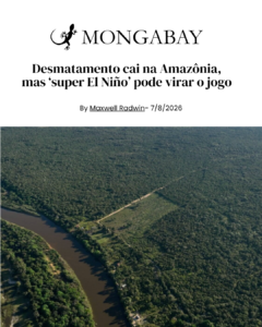
This lesson is more pressing than ever as the Amazon is under pressure from several compounding threats. A very strong El Niño is forecast for late 2026, raising the risk of another record-breaking fire season, similar to the one of 2024. Illegal gold mining continues to expand under record-high gold prices, degrading forests and rivers. Criminal networks behind mining, logging, and wildlife trafficking shift their activities to whichever jurisdiction has weaker controls, so the region’s environmental security is only as strong as its weakest link. Yet, the response has remained overwhelmingly national. ACTO is the only truly Amazon-wide platform positioned to propose a regionally coordinated response.
On this anniversary, we offer the following wishes for ACTO’s future, drawn directly from our recent research across the region:
The Amazon’s challenges have outgrown any single government’s capacity to manage them alone. ACTO already provides the institutional foundation for regional cooperation. Strengthening it, broadening its vision, and bringing more voices to the table such as: independent science, civil society, and Indigenous peoples, along governments, is one of the clearest paths toward matching the scale of the response to the scale of the challenge.
Amazon Conservation is an international conservation nonprofit working for the past 25 years towards building a thriving Amazon. The organization’s holistic approach focuses on working with local partners and allies to protect wild places, empower people, and put science and technology to work for conservation. Visit amazonconservation.org for more information.
 Behind every success at Amazon Conservation is an array of individuals with a shared passion for the Amazon: our generous donors and funders, dedicated staff (both on the ground in Latin America and at our headquarters in Washington,DC), and world-class Board of Directors. Our Board brings together passionate leaders in science, business, and conservation who selflessly lend their invaluable expertise, vision, and financial support to help protect the rainforest we all love and the people who depend on it.
Doug Sarno has focused on bringing people together to solve complex challenges. Trained as a civil and environmental engineer, he soon discovered that lasting environmental solutions depend not only on science and technology, but also on collaboration, trust, and shared vision. Over the years, he became a recognized facilitator and strategic planner, helping governments, nonprofits, and communities navigate some of the most difficult environmental issues of our time.
That passion for building partnerships eventually led him to Amazon Conservation. What began as a consulting role supporting strategic planning and board development evolved into a deeper commitment to the organization’s mission. Today, as Board Chair, Doug brings decades of experience in stakeholder engagement and consensus-building to help strengthen regional collaboration across the Amazon.
In this Q&A, Doug reflects on his path to conservation, the importance of creating trusted partnerships, and why he believes collaborative action is essential to protecting one of the planet’s most critical ecosystems.
_________________________________________________________________________________________________________________________________
Tell us a little bit about yourself.
I am originally a civil and environmental engineer, but have spent the majority of my career as a facilitator and strategic planner. Much of my work has been to convene and facilitate diverse stakeholders to create consensus on how to address the types of complex and controversial environmental issues I had worked on as an engineer. My real passion has always been planning and process. In the late 1990’s I had the opportunity to serve as Executive Director of the International Association for Public Participation where I oversaw the development of a number of seminal tools and foundational training in establishing the formal practice of Public Participation. Since then I have worked with government agencies and nonprofits as a consultant, facilitator, trainer, and strategic planner in a wide range of issues related to strategic planning, organizational effectiveness, and stakeholder collaboration.
What sparked your interest in conservation?
I have always been interested in environmental issues. In engineering school I sought to focus on environmental engineering at a time when it barely existed as a discipline. This allowed me to begin my career working for environmental consulting firms, environmental nonprofits and the Environmental Protection Agency before starting my own environmentally-focused consulting firm. Much of my work has been for agencies and nonprofits focused on conservation, environmental protection, and environmental remediation. The more I worked in this field exploring solutions to hazardous and radioactive waste disposal, recycling, and the protection of natural resources, the more I witnessed the incredible damage caused by our careless attitudes toward nature. This resulted in my commitment to be part of the solution. I look for opportunities to find balance between human activity and ensuring a sustainable environment both in my work and in my volunteer activities.
How did you first connect with Amazon Conservation?
A former client was hired by Amazon Conservation and was looking for a consultant to support strategic planning and Board Effectiveness activities. It was a good fit and I worked with Amazon Conservation on a variety of initiatives over a number of years. In the middle of one facilitation, the Board Chair asked me if I would like to join the board. I of course said yes. We joked that it was a clever way to get my services for free, but that was a deal I was more than happy to make.
From your perspective as a Board Chair, what is it that sets Amazon Conservation apart from other similar organizations?
We are a convener and collaborator of the organizations, tools, and science needed to help tackle this enormous and enormously important challenge. In that role we are able to work across political borders without any specific agenda, and without the constraints that country-specific organizations might face. This collaborative regional approach is the only way to get impact at scale. I truly believe that Amazon Conservation is committed to our work to protect and preserve the Amazon without trying to draw attention to ourselves or build the organization with any functions other than what is essential for the mission. This allows us to make sure the vast majority of all money raised goes directly to conservation efforts.
What have you learned from your Board service thus far?
I think the passion of board members for the Amazon Conservation mission is what makes this board special. There is genuine excitement to learn about the work that is happening and it is always a pleasure to be working with such a diverse group of talented people. Working with partners throughout the region provides us with a big picture view of the causes and challenges of deforestation which allows us to contemplate holistic solutions. On this board we get a front row seat to the challenges and solutions to one of the most important conservation initiatives on the planet.
Why is our mission of protecting the Amazon so important?
Beyond the oceans, the Amazon is perhaps the single largest and most important ecosystem in helping to regulate the earth’s climate. There are so many reasons to protect this diverse wild space, but it’s service as a carbon sink is especially important to maintaining a human-friendly planet. The more we see of large areas of the Amazon shifting from a carbon sink to carbon release, the more essential it becomes to find sustainable solutions to managing deforestation in our lifetime.
What advice would you give to others seeking to make a difference?
I think many of us are struggling with the immensity of the world’s challenges right now. We want to see a fairer, more humane, and greener planet but struggle to know how to be part of the solution. As so many of our institutions struggle to evolve to meet the technologies and challenges of the 21st Century, I have become more convinced that many of the solutions will fall to civil society. I am reminded of the Margaret Mead quote “Never doubt that a small group of thoughtful, committed citizens can change the world; indeed, it’s the only thing that ever has.” We need to shift our energy from doomscrolling about what a mess things are to taking some action, no matter how small, toward a future that you want to see. It does not matter what issue or how overwhelming the problem might seem. Find an organization that matches your passion and ask what you can do to help.
Is there anything else you’d like people to know about Amazon Conservation?
I was recently in Africa and spent some time with former poachers who are now part of the teams helping to protect wildlife. They explained that poaching was never something they wanted to do, but what was available to them to feed their families. They were paid little while others made a fortune on the tusks and horns that were sold for high prices. It reminded me that the solution to conservation is not brute force protection, punishing the small players while the true perpetrators continue their activities. Indeed, much of the gold mining currently destroying large areas of forest is happening in protected areas, by poor people working in terrible conditions. Catching and punishing those people might stop that mine but will not solve the problem itself. The answers are rooted in creating approaches and systems that allow the forest and humans to sustainably co-exist. I think this holistic and sustainable approach to conservation is at the heart of how Amazon Conservation works and is built into our regional partnership approach to all of our activities.
Based on your area of expertise, how would you describe the importance of creating collaborative and participatory spaces in conservation, and how do you think Amazon Conservation contributes to this?
I think that I have touched on this throughout but will add one more essential piece of the puzzle. Just as the environmental issues we are seeking to address are almost entirely the result of human action, the success of the solutions we need to build are entirely dependent on human inter-action. It is the human element that must be solved to allow nature to do its thing. To allow conservation to take place, we first need to build the understanding, trust, and relationships to change human behavior in a permanent and sustainable way. That can only occur through ongoing collaboration to address the wide range of needs and conditions that result in deforestation. In my very biased opinion as a lifelong facilitator, meaningful and sustainable collaboration can only occur within a meaningful process and with the support a trustworthy facilitation. I believe that Amazon Conservation has been demonstrating its ability to create and facilitate those collaborative spaces in its ability to convene cross border partnerships and provide the overall facilitation of parties to achieve successful outcomes.
“To allow conservation to take place, we first need to build the understanding, trust, and relationships to change human behavior in a permanent and sustainable way.”
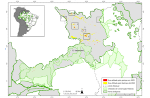
Satellite monitoring and drone analysis reveal the expansion of mining into national parks, biological reserves, and protected forests that are critical for the biodiversity and ecological connectivity of the Ecuadorian Amazon.
The expansion of gold mining in the southern Ecuadorian Amazon continues to push into strategic ecosystems and protected areas of high ecological importance. This is highlighted in the report by Fundación EcoCiencia, “MAAP #243: Mining in the Southern Ecuadorian Amazon – Zamora Chinchipe Province,” which documents the growth of mining activity within and around key conservation zones in Zamora Chinchipe.
Zamora Chinchipe, located at the southern edge of the Ecuadorian Amazon, is one of the country’s most ecologically significant regions due to its position at the transition between the Andes and the Amazon lowlands. This unique geography supports high biological diversity and includes strategic ecosystems such as cloud forests, páramos, and rare formations like the sub-Andean tepuis.
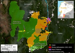 The analysis identifies approximately 111 hectares affected by mining within protected areas and conservation zones across four case studies monitored between 2011 and 2025. The impacted areas include Podocarpus National Park, the Cerro Plateado Biological Reserve, the Maycú Nature Reserve, and the Cuenca Alta del Río Nangaritza Protective Forest, territories that are essential for ecological connectivity and for conserving emblematic species such as the jaguar, tapir, and spectacled bear.
One of the most concerning findings comes from the monitoring conducted in Podocarpus National Park, where 44 hectares affected by mining were identified between August 2023 and December 2025. The study shows that mining activity is taking place inside a protected area where mineral extraction is prohibited by law. In addition to forest loss, satellite monitoring revealed impacts on the Loyola River, part of the park’s hydrological network and a key element for the conservation of cloud forests and Andean páramos.
The report also documents impacts within the Cerro Plateado Biological Reserve, a core zone of high ecological importance in the southern Amazon. Between August 2024 and December 2025, 13 hectares affected by mining were recorded, including areas inside the reserve itself. The analysis further found that 92% of the intervened areas lie outside authorized concessions, indicating possible irregular mining activities in environmentally sensitive territories.
Additional impacts were identified in the Maycú Nature Reserve, where 21.22 hectares were affected by mining, and in the Cuenca Alta del Río Nangaritza Protective Forest, with 44.27 hectares impacted. The study warns that the expansion of mining continues to increase pressure on strategic ecosystems in the Ecuadorian Amazon.
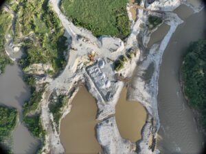
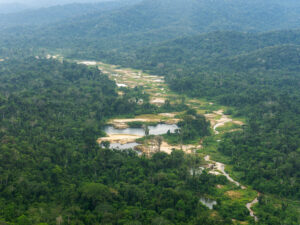
Using high-resolution satellite imagery and drone monitoring, the report identified the clearing of vegetation, soil erosion, sediment pools, and abandoned camps associated with mining activity. These findings reveal an extractive pattern marked by the repeated opening and abandonment of mining fronts, generating cumulative impacts and increasing challenges for environmental oversight.
The report also notes that Zamora Chinchipe has gone from registering around 5 hectares affected by mining in 1995 to more than 6,800 hectares in 2024, solidifying its position as one of the main hotspots of mining expansion in the Ecuadorian Amazon.
In this context, the report recommends strengthening the mandatory use of satellite-monitoring technologies and early-warning systems to detect new mining activities in protected areas and remote zones. It also underscores the need to incorporate technological evidence – such as satellite imagery, drones, and georeferencing systems – into administrative and judicial processes related to environmental crimes and illegal mining.
The study emphasizes that effectively protecting Amazonian protected areas requires reinforcing territorial control, surveillance, and institutional coordination to prevent the expansion of extractive activities in ecosystems that are critical for Ecuador’s biodiversity and ecological connectivity.
The report further warns that the rapid expansion of irregular mining activities in remote and environmentally sensitive areas poses an escalating challenge for territorial governance and the State’s capacity to exercise control. This trend highlights the need to strengthen monitoring systems, early-warning mechanisms, and more robust administrative and judicial processes to address environmental crimes and illegal mining.
Access the full report: https://www.maapprogram.org/ecuador-gold-mining-zamora/
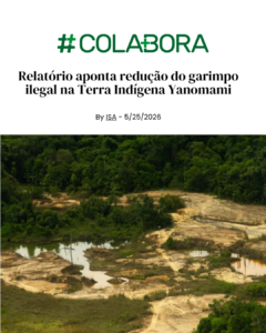
This month, our Monitoring of the Andes Amazon Program (MAAP) released two major reports on illegal gold mining in two of the Amazon’s most critical territories: the Yanomami Indigenous Territory in Brazil and the Tambopata National Reserve in Peru. The findings are both encouraging and deeply alarming.
Brazil: Progress in Yanomami, but miners are adapting
 The new report released by Instituto Socioambiental (ISA) in partnership with our MAAP initiative, documents a sharp decline in mining-driven deforestation inside the Yanomami Indigenous Territory following the Brazilian government’s large-scale intervention in 2023. Newly cleared mining areas dropped from roughly 1,800 hectares in 2022 to just 45 hectares in 2025. This means a reduction of over 90%. But the threat has not gone away, it has shifted. Satellite mapping shows that illegal miners have adopted a more decentralized tactic and are moving toward areas closer to the Venezuelan border to evade enforcement. The Yanomami Indigenous Territory Alert System recorded 66 territorial alerts in 2025 alone, the majority involving clandestine aircraft, river incursions, and the movement of supplies into mining zones.
Peru: A dangerous resurgence in Tambopata
 The analysis conducted by Conservación Amazónica–ACCA, in partnership with our MAAP initiative, documented more than 500 hectares of forest lost, and identified 183 active mining structures, 67 illegal camps, and an estimated 1,000 people currently operating within the protected area. What makes this resurgence especially alarming is that mining is now expanding close to government control posts inside the reserve, significantly increasing risks for the park rangers who defend it. In 2025 alone, mining-driven deforestation inside Tambopata exceeded 400 hectares, surpassing even the worst years of incursions recorded between 2016 and 2017. The report points some factors driving this return: record-high international gold prices, weakened environmental regulations, and reduced enforcement capacity, all creating conditions in which criminal networks can reorganize faster than the State can respond.
Together, these two reports show a defining challenge for the Amazon: enforcement works, but it must be sustained in order to protect these territories.
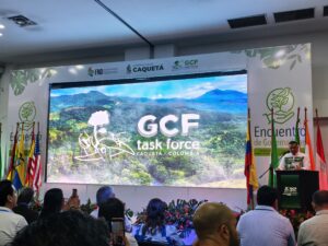 Earlier this month, Amazon Conservation joined climate and forest leaders from around the world at the 16th Annual Meeting of the Governors’ Climate and Forests Task Force (GCF Task Force), held in Caquetá, Colombia from May 18–22, 2026. The GCF Task Force unites 45 subnational governments across 11 countries, representing more than a third of the world’s tropical forests.The meeting brought together subnational governments, Indigenous Peoples and local communities, civil society, and the private sector around the theme “New Forest Economy for Climate Action: Territorial Development and Innovation.”
At the meeting, Amazon Mining Watch was highlighted as a valuable tool in the fight against illegal gold mining across the Amazon basin . Discussions made clear that more tools of this kind are urgently needed. Amazon’s Conservation participation in spaces like this is invaluable for building the alliances and cross-sector collaboration required to make lasting progress.
Andrés Santana, Amazon Conservation’s Senior Manager for Combating Illegal Deforestation, shared his reflections on the meeting: “Since its creation, the GCF Task Force has been mainly oriented to building a forest-based economy, highlighting the role that regional governments can play. This year’s annual meeting was a milestone because organizers and members are increasingly acknowledging the importance of tackling environmental crimes that are preventing the enabling conditions necessary for a thriving bioeconomy.”
The week also included field visits across Caquetá, where participants explored community-led initiatives in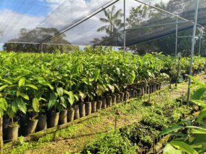 sustainable ranching, agroforestry, and bioeconomy, living proof that forest-compatible economies are not just possible, but already being built. “During the field visit to the “Territorial Space for Training and Reintegration – ETCR Aguabonita” we could witness first hand how a new and prosperous forest economy can help social reconciliation in post conflict zones by harvesting and transforming fruits such as Açaí, Canangucha, Copoazú and other Amazonian products. That is true peace with nature” states Santana.
At Amazon Conservation, we recognize the importance of these initiatives for long-term forest conservation. Visiting them is an opportunity to learn, connect, and strengthen our work across the region.
Click on the headlines to read the full story.
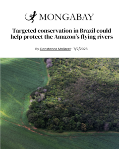
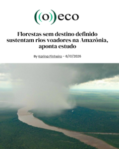
Flying rivers that sustain forests, agriculture, and water security across the Amazon are increasingly at risk from deforestation and infrastructure expansion.
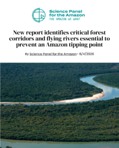
 The white paper, Keeping the Flying Rivers Flowing: How Deforestation in the Brazilian Amazon Threatens Rainfall in Peru and Bolivia, released by Amazon Conservation, maps for the first time the flying rivers that span the South American continent and their role in keeping the Amazon Rainforest’s tipping point at bay.
Flying rivers are seasonal pathways of atmospheric moisture flows that act like highways carrying water in the atmosphere, from the Atlantic Ocean to the Andes Mountains and providing vital water resources to the nine countries that form the Amazon Basin. The analysis goes beyond simply identifying the invisible flying rivers’ trajectory to pinpoint the forests most critical to maintaining this system and the areas where deforestation and planned infrastructure projects pose the greatest risks to these pathways.
The report finds that forests and ecosystems in the southwestern Amazon in Bolivia and Peru depend on flying rivers for more than 70% of their annual precipitation. As deforestation advances along these moisture pathways, the forest’s ability to recycle rainfall weakens, increasing the likelihood of drought and ecosystem collapse. The study highlights the dry season flying river as the most vulnerable moisture flow in the Amazon. These findings come after the severe 2023–2024 Amazon drought, the most intense on record, which caused devastating impacts across the region. In Bolivia, soy production in Santa Cruz dropped by 75%, while potato harvests in Peru’s Puno region fell dramatically. River systems, hydropower generation, and bioeconomies dependent on healthy forests, such as Brazil nut production, were also severely affected..
“Flying rivers are the invisible engine that sustains life, productive ecosystems, and identity in northern Bolivia. In the department of Pando, where the forest cover still maintains high levels of integrity, this climatic phenomenon is not an abstract concept; it is the direct regulator of the productive cycles of local communities that depend on the fruits produced by their forests,” states Daniel Larrea, Director of Science and Technology at Conservación Amazónica-ACEAA.
Another one of the report’s key findings is the strategic importance of conserving forests in western Brazil, particularly in the state of Acre, where all three seasonal flying river pathways converge before carrying atmospheric moisture toward Peru and Bolivia. This critical corridor acts as a bottleneck for the Amazon’s water cycle, making it especially vulnerable to disruptions caused by deforestation and infrastructure expansion. The pathway already crosses heavily deforested regions across Brazil, including southern Pará, and faces mounting pressure from planned road and infrastructure projects connecting Brazil and Peru. Among the most concerning examples is the BR-319 highway, whose paving could trigger more than 12 million acres of additional deforestation and significantly weaken the forest’s capacity to recycle rainfall across the Amazon Basin.
“These communities have no representation in the infrastructure licensing or land designation decisions that increase deforestation risk. The paper advocates for closing this gap between transboundary impact and national-scale decision making,” states Blaise Bodin, Director of Strategy and Policy at Amazon Conservation.
Mapping strategic areas where prioritized conservation is needed
To address the growing threats to flying rivers, the report introduces the concept of Critical Moisture Territories: forests at high risk of deforestation that play a vital role in moisture recycling and keeping the flying rivers flowing. Many of the Amazon’s most important Critical Moisture Territories coincide with Brazil’s Undesignated Public Forests (UPFs) or Florestas Públicas Não Destinadas (FPND), making them among the most strategically important areas for prioritized conservation efforts to maintain the flying rivers system. Nearly more than 12 million acres of public Amazon forest currently lack formal legal protection, and many lie directly within key flying rivers paths, leaving these critical atmospheric corridors highly vulnerable to disruption by the impacts of deforestation driven by logging, land grabbing, mining, fires, and other human-caused activities. According to the report, formally protecting these forests could be one of the most effective ways to safeguard the Amazon’s atmospheric water cycle and reduce the risk of widespread regional drought.
Among the report’s six recommendations is the call to move beyond reactive law enforcement and adopt coordinated Amazon-wide policies that recognize Brazil’s critical role in sustaining the flying rivers across the continent and increase conservation efforts and investments in the most vulnerable areas in Bolivia and Peru. The report also highlights the need for forest restoration, climate adaptation strategies, and stronger science and technology to guide conservation decisions.
“At a country level, we need to double down on science to understand exactly how biodiversity is responding to climate change, both higher temperatures and a reduction in rainfall carried by flying rivers. In parallel, we must maintain and expand the forested connection between the slopes of the Andes and the Amazonian lowlands, creating and conserving these key climate corridors,” states Dr. Corine Vriesendorp, Director of Science at Conservación Amazónica-ACCA in Perú.
A foreword by renowned Brazilian scientist Carlos Nobre, whose groundbreaking work with American biologist Thomas Lovejoy helped shape the global understanding of the Amazon tipping point, speaks to how decision-makers can use this analysis in policies and action: “This white paper by Amazon Conservation represents an important and timely contribution to this body of knowledge. By identifying the forests most critical to maintaining atmospheric moisture transport, it offers a practical pathway from science to action. The window to act is still open, but it is narrowing. Strengthening the resilience of flying rivers through science-backed, prioritized conservation actions is a vital step in the right direction. This white paper offers a valuable, actionable guide to doing so.”
The report was developed by Amazon Conservation in collaboration with researchers and partner institutions across the Amazon Basin, including the Institut des Géosciences de l’Environnement (IGE), Universidade Federal de Santa Catarina, IPAM, FAS (Fundação Amazônia Sustentável), Conservación Amazónica–ACCA, and Conservación Amazónica–ACEAA.
Read the white paper: https://www.amazonconservation.org/publication/
Illegal mining–driven deforestation reached its peak in 2022, when roughly 1,800 hectares were cleared. In 2025, monitoring still identified an additional 45.2 hectares of new forest loss.
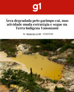
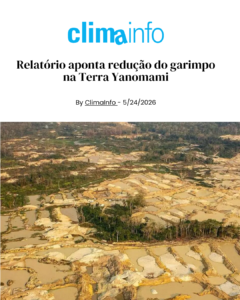
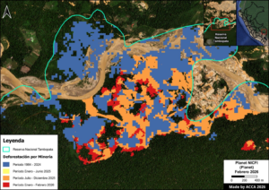
Deforestation driven by illegal mining in the Yanomami Indigenous Territory has dropped sharply over the past three years, following a surge in 2021 and 2022. That’s the conclusion of a new report released this Friday (May 22) by the Instituto Socioambiental (ISA), in partnership with MAAP (Monitoring of the Andes Amazon Program), an initiative of the Amazon Conservation Association.
According to the report, satellite mapping suggests that invaders have changed the way they operate in response to increased enforcement, adopting more decentralized tactics and moving toward areas closer to the Venezuelan border. These findings are reinforced by complaints recorded in the Yanomami Indigenous Territory Alert System, which show that both aerial and river‑based incursions continue.
According to the report, the Yanomami Indigenous Territory has accumulated 5,564 hectares of land degraded by illegal mining. The material produced by ISA and the Amazon Conservation Association was developed in partnership with the Hutukara Associação Yanomami (HAY) and the Associação Wanasseduume Ye’kwana (Seduume).
In 2025, 45.2 new hectares were deforested as a result of illegal mining in the territory, nearly half of the 84 hectares recorded in 2024. According to the report, this figure is a warning sign: despite the slowdown in mining activity, the opening of new areas shows that the illegal operations have not been fully neutralized.
In 2023, when the Federal Government declared a Public Health Emergency of National Importance in the territory, 330 hectares of expansion were recorded – an 81.6% reduction compared to the previous year.
In 2020, 400 hectares were deforested, and in 2021 the figure rose to more than 1,000 hectares. The year 2022 saw the largest increase, with approximately 1,800 hectares cleared.
This monitoring is carried out monthly through the visual interpretation of satellite images by geoprocessing specialists. Based on these images, degradation polygons are drawn. Each month, the affected areas are revisited to refine the mapping and check for possible errors.
New areas impacted
 In 2025, the mapping identified 121 polygons of newly impacted areas linked to illegal mining, 90% of them measuring one hectare or less. The two largest polygons – each roughly four hectares – are located in the Parima and Surucucus regions, specifically near the Feijão Queimado airstrip in Roraima.
The report also notes that illegal miners have dispersed their activities, avoiding the large concentrations seen before federal operations began. Areas previously exploited to exhaustion, such as Alto Catrimani, Médio Uraricoera and Homoxi, now appear to be relatively neutralized.
New tactics
To evade enforcement, the invaders continue relying on the tactic of moving toward areas closer to the Venezuelan border. In this context, the report identified new scars in Parafuri‑Parima, Hokomawë and Cabeceira do Aracaçá.
In 2025, the Yanomami Indigenous Territory Alert System – created and used by organizations within the Yanomami Territory – recorded at least five alerts related to the movement of clandestine aircraft in the Auaris region. In most cases, the aircraft were flying toward Hokomawë, either in the direction of the Gaúcho Animal airstrip, located at the mouth of the Auaris River, or toward the airstrip at the headwaters of the Aracaçá River.
According to ISA geographer Estêvão Senra, with gold prices reaching historic highs on the international market, pressure from illegal mining remains constant.
“Eviction operations are an essential first step, but on their own they do not solve the structural problem. Without medium‑ and long‑term territorial protection strategies – including permanent surveillance and improvements in the regulation of the gold supply chain – there is a significant risk of seeing a new wave of invasions in the near future.”
The same pattern has been observed in other parts of the Amazon where eviction and enforcement operations have taken place, such as the Madre de Dios region in Peru, which destroyed more than 100 mining dredges in recent years. Now, satellite data show the return of incursions into protected areas, including the Tambopata National Reserve, according to a recent report also released by MAAP.
Matt Finer, director of the MAAP program at Amazon Conservation, emphasizes that the data show governments are capable of reducing illegal mining when coordinated interventions and effective enforcement efforts are in place. “In the Yanomami Indigenous Territory, illegal mining reached its peak between 2021 and 2022 but dropped significantly after the major intervention by the Brazilian government beginning in 2023. However, as we have recently observed in Peru and Venezuela, these actions must be part of a continuous, long‑term effort. Otherwise, illegal mining tends to return quickly.”
Territorial Alerts
In 2025, the alert system recorded a total of 66 territorial alerts. Of these, 83% were invasion alerts, which include information on the movement of clandestine aircraft, boats, barges and other vehicles. There were also reports of attacks and the entry of firearms.
The alert system is an initiative of the organizations of the Yanomami Indigenous Territory: Hutukara Associação Yanomami, Associação Wanasseduume Ye’kwana, Urihi Associação Yanomami, Parawamë, Kurikama, AYRCA and Kumirayoma, with technical support from ISA and backing from the United Nations Children’s Fund (Unicef). The tool began to be implemented in 2023.
Read also Yanomami Indigenous issue cell phone alerts to defend their territory
The system allows community monitors to send alerts through a form with photos, videos, audio recordings and geolocation, even offline. The information is validated and translated by Indigenous researchers, organized into a public dashboard, and forwarded to the authorities. The tool is available in four languages: Yanomami, Ye’kwana, Sanoma and Portuguese.
Among the regions that recorded alerts of airspace invasion, in addition to Auaris, are Xitei, Alto Catrimani and Apiaú (possibly linked to mining activity on the Couto Magalhães River).
“In the case of Catrimani, the link between this movement and the mining activity taking place at the headwaters of the Orinoco, in Venezuelan territory, one of the areas with the highest miner activity in recent years, is striking,” the report notes.
The Taboca airstrip, located in Venezuela, is identified as a strategic part of the logistics that sustain illegal mining in Brazil. The airstrip supports invaders who continue to operate in the Alto Catrimani and Xitei regions.
According to the report, the Ericó region, an area accessible via the Uraricaá River, showed significant signs of deforestation linked to mining activity. During the most critical phase of the invasion, there were reports of dredges operating on the Uraricaá River, but no signs of mining on land. That scenario appears to have changed as part of the invaders’ strategy to evade operations in more heavily monitored areas.
Alerts submitted through the system also indicate the persistence of incursions along the Uraricoera, Catrimani, Apiaú and Ajarani rivers. Reports include barge traffic, dredge operations, the transport of cassiterite and the entry of supplies into mining camps.
Baixo Catrimani is the region that reported the highest number of river‑based invasions. From April to December 2025, the Yanomami sent nine alerts about the presence of barges, dredges and the movement of suspicious boats.
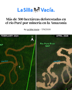
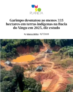
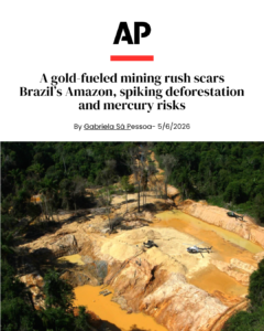
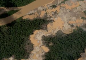
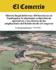
Seven years after the historic Operación Mercurio was launched, illegal gold mining has surged back inside the Tambopata National Reserve, one of the most important protected areas in the southern Peruvian Amazon.
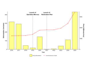 A new high‑resolution satellite analysis by Conservación Amazónica–ACCA reveals a troubling resurgence of mining activity during the second half of 2025 and the early months of 2026. This renewed expansion has already resulted in the loss of 500 hectares of Amazonian forest within the reserve.
The findings are presented in the latest MAAP Report #241, which documents not only the scale of the environmental destruction but also the intensifying criminal pressure on an ecosystem that is critical to global biodiversity.
A resurgence surpassing even the most critical years
The data show that in 2025 alone, mining‑driven deforestation inside Tambopata exceeded 400 hectares, a figure that surpasses the levels recorded during the most critical years of illegal mining incursions, between 2016 and 2017.
This new wave of expansion is concentrated primarily in the northern part of the reserve, in areas adjacent to the Malinowski River, a corridor long recognized as highly vulnerable to the entry of illegal operators.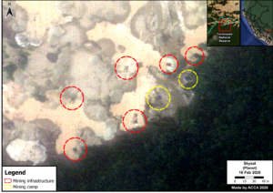
Using 0.5‑meter‑resolution Skysat satellite imagery, the technical team identified 183 active mining structures, 67 illegal camps, and five major mining hubs operating within the reserve.
Drawing on the detected infrastructure and ACCA’s previously developed models, the analysis estimates that around 1,000 people may currently be involved in illegal gold extraction inside the protected area.
Illegal mining advances near State-run control posts
One of the report’s most troubling findings is that mining activity is now expanding in areas close to several control posts inside the Tambopata National Reserve, including Otorongo, Azul, and Yarinal.
Satellite imagery reveals a clear pattern: the opening of new mining pits, the installation of heavy machinery, and the steady growth of illegal camps within the protected area.
The most affected zones include Isla Córdoba, with 106 hectares deforested, 53 mining pits, and 20 camps; A4, with 101 hectares impacted, 68 mining structures, and 33 camps; and Isla Correntada, where 111 hectares have been affected and active machinery and illegal camps remain visible.
“It is particularly alarming that a significant share of the illegal mining advance is taking place inside the reserve and in areas close to control posts. This greatly heightens the risks faced by the park rangers responsible for safeguarding the Tambopata National Reserve and underscores the urgent need for broader, more decisive measures to prevent potential situations of violence or confrontation on the ground,” said Sidney Novoa, Director of Conservation Technologies at Conservación Amazónica–ACCA.
What is driving the return of illegal mining?
The report points to a convergence of economic, institutional, and political factors behind this renewed expansion. A key driver is the sustained rise in international gold prices, which reached record highs in 2025 and significantly increased the profitability of illegal extraction.
 The analysis also warns that the current political and institutional climate may be enabling the resurgence of these illicit economies. Contributing factors include repeated extensions of the Reinfo registry, the weakening of regulations aimed at combating organized crime, the advancement of legislative proposals that could heighten extractive pressure on protected areas, and the budget constraints faced by the agencies responsible for oversight and enforcement.
Against this backdrop, the situation in Tambopata illustrates that enforcement operations alone are insufficient when environmental monitoring, regulatory oversight, and organized‑crime prevention mechanisms are being eroded. “Protecting natural protected areas requires regulatory stability, a sustained and effective State presence, and comprehensive measures that reduce the incentives currently fueling the expansion of these illegal economies,” said Gaby Rivandeneyra, Project Lead at DAR and representative of the Illegal Mining Observatory (OMI, the acronym in Spanish).
Enforcement operations fall short of stopping the advance
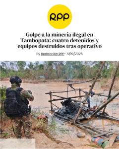
Between January and March 2026, joint operations involving law‑enforcement agencies, environmental prosecutors, and other competent authorities succeeded in seizing and destroying machinery, fuel, engines, and camps linked to illegal mining.
However, satellite monitoring shows that, despite these interventions, the activity continues across the area.
This underscores a widening gap between the State’s operational response capacity and the speed with which criminal networks are able to reorganize and resume operations.
“The situation in the Tambopata National Reserve is emblematic for the entire Amazon. It shows that committed governments can confront illegal mining, but that the activity can return quickly if that commitment weakens,” said Matt Finer of Amazon Conservation.
A threat to biodiversity and to those who defend it
The Tambopata National Reserve protects some of the most biodiverse ecosystems on Earth. Yet the advance of illegal mining threatens not only its forests and waterways, but also the people who risk their safety to defend this territory.
Amid rising violence against environmental defenders in Madre de Dios, the report’s findings show that this new expansion is driven not only by criminal networks, but also by a deepening erosion of environmental governance.
Today, Tambopata is once again confronting a threat that puts decades of conservation efforts in the Peruvian Amazon to the test.
You can read the full report here:
https://www.maapprogram.org/mining-peru-tambopata/
————————————————————————————————————————-
About the report
MAAP Report #241 was prepared by the Amazon Conservation’s Monitoring of the Andean Amazon Project (MAAP), in partnership with Conservación Amazónica–ACCA, leading this report. The analysis draws on high‑resolution satellite imagery, historical geospatial datasets, and a review of the political and institutional context surrounding illegal gold mining in the Peruvian Amazon.
 Loading...


1025 Connecticut Ave NW · Suite 415 · Washington DC 20036 · USA
202-234-2356 / info@amazonconservation.org