20 for 20: Los Amigos Biological Station and Conservation Concession

Los Amigos Conservation Concession Sign, part of the 20 for 20 Conservation Wins Series by Amazon ConservationBecause 2020 marks our 20th anniversary protecting the Amazon, we’re closing out this year by celebrating this milestone with a look back at our biggest conservation wins. To kick off the countdown, we’re commemorating the establishment of our Los Amigos Biological Station and Conservation Concession, located in Madre de Dios, Peru.

When we established the Los Amigos Conservation Concession in 2001, it was the first private conservation concession in the world. Located in the Los Amigos watershed in the department of Madre de Dios in southwestern Peru, the 360,000-acre concession borders the world-famous Manu National Park, and is a mosaic of terrestrial and aquatic habitats, including old-growth Amazonian forest, palm swamps, and bamboo thickets. Wildlife is abundant, including 12 globally threatened species, 11 primate species, and over 550 bird species.

What is a conservation concession? In Peru, as in other countries in Latin America, a substantial portion of land is publicly owned. Conservation concessions entrust long-term protection of publicly owned land to non-profit institutions or other entities in exchange for investments in conservation and sustainable development. This allows private organizations such as ACA to assist the Peruvian government in achieving national biodiversity conservation goals.

Los Amigos Biological Station, part of the 20 for 20 Conservation Wins Series by Amazon ConservationAdjacent to the concession is our Los Amigos Biological Station, established in 2000, which was built on the conviction that the greatest forest on earth deserves the best research centers in the world. The 1,119-acre station is situated in the lowland Amazonian forest at the base of Peru’s southern Andes, at the tip of a peninsula on a high terrace between the Madre de Dios and Los Amigos rivers.

Since its establishment, researchers have conducted studies at the station addressing botany, conservation biology, geology, hydrology, and zoology, among others. Additionally, many field courses have been held at the station with students from Peru and around the world. Los Amigos is also a training site for young Amazonian scientists, offering opportunities for area students to visit the station for a hands-on learning experience in tropical ecology and environmental issues.

Efforts to build bricks-and-mortar institutions for the long haul were historically rare in Amazonia. Los Amigos became a model protected area, model research station, model training center, and model partnership rolled into one and since then there have been various other institutions replicating their own versions of this model throughout the Amazon.

Click here to help keep Los Amigos protected and support the establishment of other protected areas in the Amazon.

Mail Delivery Issue for Amazon Conservation’s DC Office Address *12/10 UPDATE: Issue is Resolved*

**UPDATE AS OF DECEMBER 10, 2020**

The USPS has fixed this error and our office is once again able to send and receive mail as usual.

If your mail to us was returned, we kindly ask that you please re-send it to our regular office address at 1012 14th Street NW, Suite 625, Washington, DC, 20005. We apologize for this inconvenience. If you’d like to send us any registered mail or mail that needs a signature or in-person receipt, please contact Ana Folhadella, Communications and Development Manager, using the contact information below to get a staff member’s direct mailing address.

Direct Email: afolhadella@amazonconservation.org
Office Number: (202) 234-2356
Personal Cellphone: (202) 930-1421

As the global pandemic continues, please note that our DC staff is following local recommendations and working from home, so there may be some delay in acknowledging receipt and processing your mail to us. The processing of check contributions and sending of acknowledgment letters with tax-deduction may be slightly delayed, however, all check contributions postmarked in 2020 received up until January 10th, 2021 will be honored as donations for the year 2020 for income tax purposes. If you have any questions about your donation or would like your tax documentation emailed to you, please feel free to contact our Communications and Development Manager using the direct information above or at info@amazonconservation.org.

Thank you for your patience, understanding, and support!


IMPORTANT NOTICE (December 4):

Dear supporters and friends of the Amazon,

We recently discovered an issue with Amazon Conservation’s USPS account that is affecting mail to and from our DC office.

If you have mailed us a donation, letter, or any materials via any postal carrier to our office address at 1012 14th Street NW, Suite 625, Washington, DC, 20005, any time between October 1 2020 and now, your mail may have been affected. This means we likely did not receive your mail and that USPS will be returning it to you, the sender. Some donors have reported that they received their envelopes back with a yellow notice saying that mail is “undeliverable to this address” or “unable to forward.” Please note that the address above is correct and will continue to be our mailing address for the foreseeable future – this message is an error on USPS’ system that we are trying to correct.

To make sure your mail and contributions get to us in a timely manner, please contact us‬ using the information below to get a secondary mailing address while we fix this issue. We can also process donations online on your behalf for your convenience. Unfortunately, USPS is unable to tell us if a specific piece of mail has been affected without a tracking number.

The USPS error also affected some of our outgoing mail sent between October 1 and November 30. If you were expecting something in the mail from us (such as a donation acknowledgment letter with a tax receipt for a recent contribution) and have not received it, please contact us using the information below. To be safe and ensure that our donors receive their tax-deduction materials promptly, we will be re-issuing all donation receipt letters that had been sent in the past 4 months (September – November 2020).

If you made a donation electronically via our website, Charity Navigator, an employee giving program, or any other online platform, your donations have not been affected and were processed as usual. You should have received an automatic receipt with the needed tax-deductible information to the email account you used when making the contribution. If you have questions about your online donations, please reach us at donations[at]amazonconservation[dot]org. We are not affiliated with Amazon.com, Inc.

Thank you for your patience and understanding as we work with the USPS to fix this issue. This post will be updated as new information is made available.

Please direct any questions, comments, or concerns about Amazon Conservation’s mail to:
Ana Folhadella, Communications and Development Manager
Direct Email: afolhadella@amazonconservation.org
Office Number: (202) 234-2356
Personal Cellphone: (202) 930-1421

MAAP #130: Illegal Gold Mining Down 78% In Peruvian Amazon, But Still Threatens Key Areas

As part of USAID’s Prevent Project (dedicated to combating environmental crimes in the Amazon), we conducted an updated analysis of illegal gold mining deforestation in the southern Peruvian Amazon.In early 2019, the Peruvian government launched Operation Mercury, an unprecedented crackdown on the rampant illegal gold mining in the region.The Operation initially targeted an area known as La Pampa, the epicenter of the illegal mining. In 2020, it expanded to surrounding critical areas.

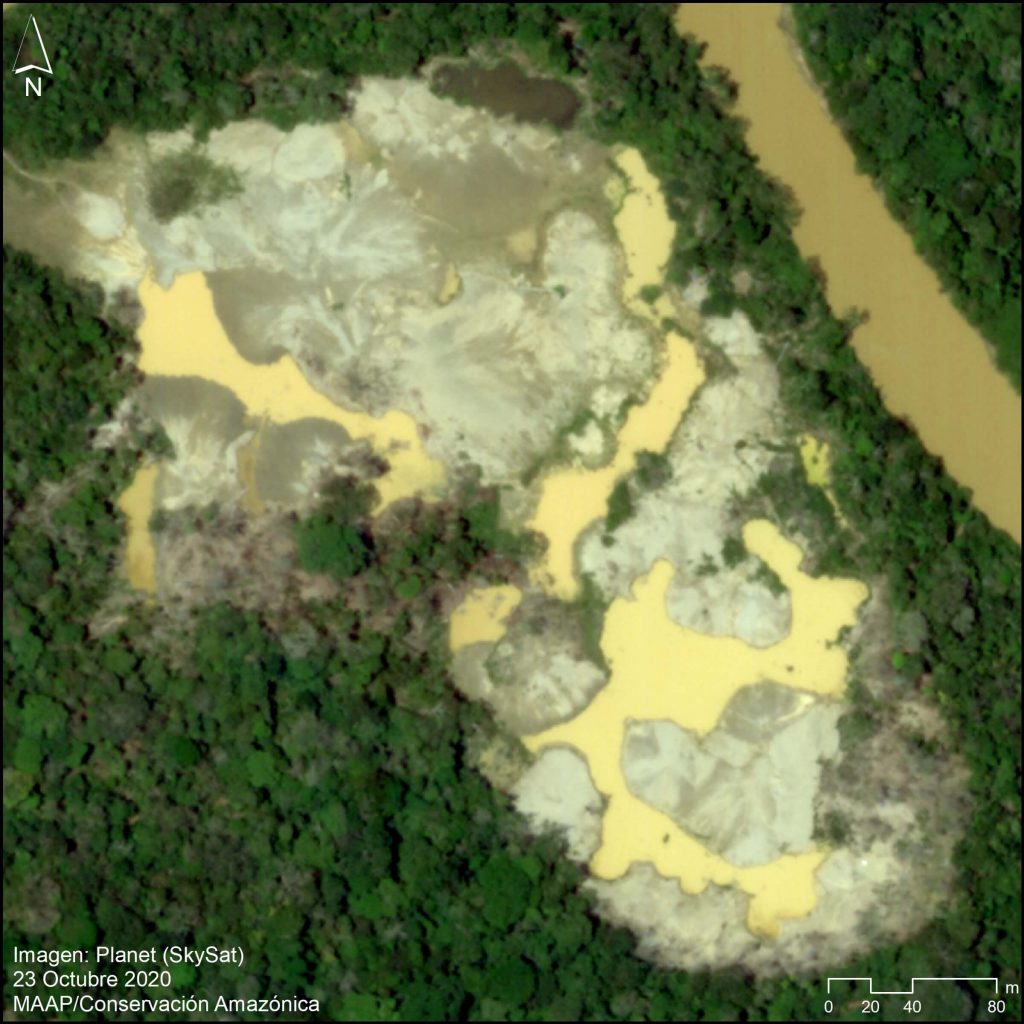
Image 1. Very high resolution image of recent gold mining deforestation along the Pariamanu River. Data: Planet (Skysat).

In this report, we compare rates of gold mining deforestation before vs after Operation Mercury at six key sites (see Base Map and Methodology below).

We report four major results:

1) Gold mining deforestation decreased 90% in La Pampa (the most critical mining area) following Operation Mercury.

2) Gold mining deforestation increased in three key areas –Apaylon, Pariamanu, and Chaspa – indicating that some miners expelled from La Pampa moved to surrounding areas. The Peruvian government, however, has recently carried out major interventions in all three of these areas.

3) Overall, gold mining deforestation decreased 78% across all six sites following Operation Mercury.

4) Illegal mining does persist, however. We documented 1,115 hectares of gold mining deforestation across all six sites since Operation Mercury (but, compared to 6,490 hectares before the Operation).

Below, we provide a more detailed breakdown of the major results across all six sites. We also present a series of very high resolution satellite images (Skysat) of the recent gold mining deforestation.


Base Map – 6 Major Illegal Gold Mining Sites

The Base Map illustrates the results across the six major gold mining fronts in the southern Peruvian Amazon. Red indicates gold mining deforestation post Operation Mercury (March 2019 – October 2020), while yellow indicates the pre Operation baseline (January 2017 – February 2019).

Base Map. Major gold mining fronts in the southern Peruvian Amazon before (yellow) and after (red) Operation Mercury. Data: MAAP.

In La Pampa, we documented the dramatic loss of 4,450 hectares within the buffer zone of Tambopata National Reserve (Madre de Dios region) prior to Operation Mercury. Following the Operation, we confirmed the loss of 300 hectares. Note the main mining front in the core of the buffer zone has essentially been stopped, with most recent activity further north near the Interoceanic Highway.

In neighboring Alto Malinowski, located in the buffer zone of Bahuaja Sonene National Park (Madre de Dios region), we documented the loss of 1,558 hectares prior to Operation Mercury. Following the Operation, we confirmed the loss of 419 hectares.

In Camanti, located in the buffer zone of Amarakaeri Commuanl Reserve, we documented the loss of 336 hectares prior to Operation Mercury. Following the Operation, we confirmed the loss of 105 hectares.

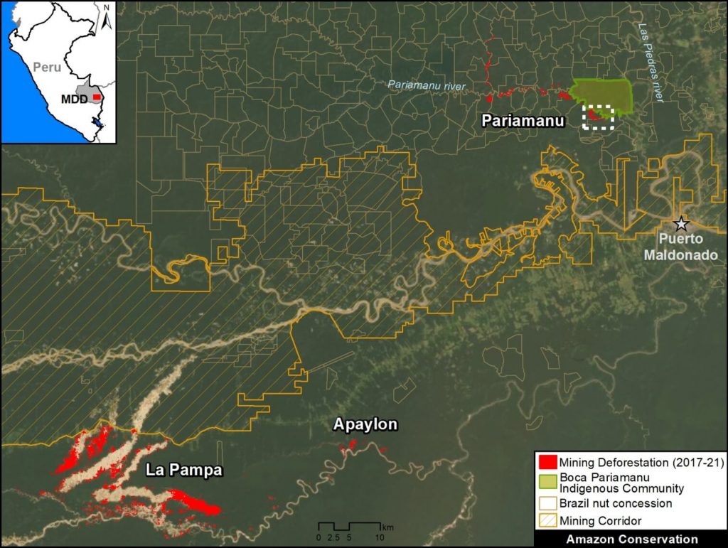
In Pariamanu, located in the primary forests along the Pariamanu River (Madre de Dios region), we documented the loss of 72 hectares prior to Operation Mercury. Following the Operation, we confirmed the loss of 98 hectares. In response, the government conducted a major intervention in August 2020.

In Apaylon, located in the buffer zone Tambopata National Reserve (Madre de Dios region), we documented the loss of 73 hectares prior to Operation Mercury. Following the Operation, we confirmed the loss of 78 hectares. In response, the government has conducted a series of interventions in the area during 2020.

Chaspa, located in the buffer zone of Bahuaja Sonene National Park (Puno region), represents a unique case of a new gold mining front that appeared following Operation Mercury. Starting in September 2019, we documented the deforestation of 113 hectares impacting the Chaspa River watershed. In response, the government conducted a major intervention in October 2020.


Gold Mining Deforestation Trends

The following chart illustrates that gold mining deforestation fronts decreased following Operation Mercury in the three largest fronts (La Pampa, Alto Malinowski, and Camanti), and increased in three smaller areas (Pariamanu, Apaylon, and Chaspa). Thus, overall gold mining deforestation decreased 78% across all six major sites following Operation Mercury.

Table 1. Rates of gold mining deforestation before (orange) and after (red) Operation Mercury. Data: MAAP.


In La Pampa, the gold mining deforestation averaged 165 hectares per month prior to Operation Mercury. Following the Operation, the deforestation dropped to 17 hectares per month, an overall 90% decrease.

In Alto Malinowski, the gold mining deforestation dropped from 58 hectares per month to 23 hectares per month following Operation Mercury, an overall 60% decrease.

In Camanti, the gold mining deforestation dropped from 12.5 hectares per month to 6 hectares per month following Operation Mercury, an overall 54% decrease.

In Pariamanu, the gold mining deforestation increased from 2.8 hectares per month to 5 hectares per month following Operation Mercury, an overall 87% increase.

In Apaylon, the gold mining deforestation increased from 2.8 hectares per month to 4 hectares per month following Operation Mercury, an overall 43% increase.

Chaspa, located in the buffer zone of Bahuaja Sonene National Park, represents the unique case of a new gold mining front that appeared following Operation Mercury (8.5 hectares per month).


Very High Resolution Satellite Imagery (Skysat)

We recently tasked very high resolution satellite imagery (Skysat, 0.5 meter) for the major illegal gold mining areas. Below, we present a series showing some of the highlights from these images. Note that insets (in the upper corner of each image) show the same area before the mining activity (see red points as a reference).

Pariamanu

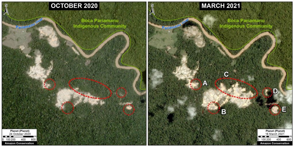
The following two images show the expansion of new gold mining areas into the primary rainforests near the Pariamanu River (Madre de Dios region).

Image 2. Expansion of new gold mining areas into the primary rainforests near the Pariamanu River (Madre de Dios region). Data: Planet.


Image 3. Expansion of new gold mining areas into the primary rainforests near the Pariamanu River (Madre de Dios region). Data: Planet.

La Pampa

The following image shows the expansion of a new gold mining area in the northern part of La Pampa.

Image 4. Expansion of a new mining area in the northern part of La Pampa (Madre de Dios region). Data: Planet, Maxar.


Chaspa

The following image shows the sudden appearance of a new gold mining front along the Chaspa River (Puno region).

Image 5. New gold mining front along the Chaspa River (Puno region). Data: Planet (Skysat).


Camanti

The following image shows the recent expansion of gold mining deforestation in the buffer zone of Amarakaeri Communal Reserve (Cusco region).

Image 6. Recent expansion of gold mining deforestation in the buffer zone of Amarakaeri Communal Reserve (Cusco region). Data: Planet (Skysat).


Methodology

We analyzed high-resolution imagery (3 meters) from the satellite company Planet obtained from their interface Planet Explorer. Based on this imagery, we digitized gold mining deforestation across six major sites: La Pampa, Alto Malinowski, Camanti, Pariamanu, Apaylon, and Chaspa. These were identified as the major active illegal gold mining deforestation fronts based on analysis of automated forest loss alerts generated by University of Maryland (GLAD alerts) and the Peruvian government (Geobosques) and additional land use layers. The area referred to as the “mining corridor” is not included in the analysis because the issue of legality is more complex.

Across these six sites, we identified, digitized, and analyzed all visible gold mining deforestation between January 2017 and the present (October 2020). We defined before Operation Mercury as data from January 2017 to February 2019, and after Operation Mercury as data from March 2019 to the present. Given that the former was 26 months and the latter 20 months, during the analysis the data was standardized as gold mining deforestation per month.

The data is updated through October 2020.


Acknowledgments

We thank A. Felix (DAI), S. Novoa (ACCA), and G. Palacios for their helpful comments on this report.

This report was conducted with technical assistance from USAID, via the Prevent project. Prevent is an initiative that is working with the Government of Peru, civil society, and the private sector to prevent and combat environmental crimes in Loreto, Ucayali and Madre de Dios, in order to conserve the Peruvian Amazon.

This publication is made possible with the support of the American people through USAID. Its content is the sole responsibility of the authors and does not necessarily reflect the views of USAID or the US government.

USAID logo

Citation

Finer M, Mamani N (2020) Illegal Gold Mining Down 79% in Peruvian Amazon, But Still Threatens Key Areas. MAAP: 130.

Download PDF of this article >>

Giving Tuesday: A Different Way to Give

Sparkling Violetear photo by Trond Larsen taken at WayqechaEven in a year as unexpected and uncertain as 2020, our supporters have continued to show up when we’ve needed you most. So this Giving Tuesday we’re not asking for you to lend us hand with a financial contribution (although, of course, we always welcome donations to make conservation happen!), but we’re asking you to do one simple thing: SHARE!

Help us spread awareness about the Amazon Rainforest by sharing one post – any post – from our Facebook, Twitter, Instagram, or LinkedIn pages and tell your friends and family why it matters to you.


Here are some ideas, but feel free to choose something else and make it your own!

Support Conservation in the Amazon While Holiday Shopping

Photo of a Jabiru by Sean WilliamsDid you know that you can help save the Amazon while holiday shopping? Support our conservation work and get your holiday shopping finished in one fell swoop by shopping through AmazonSmile or the Good Deeds App.

AmazonSmile

The AmazonSmile Foundation recently surpassed $200 million in donations to charities worldwide. By shopping AmazonSmile you receive the same products, prices, and services, and Amazon will donate 0.5% of a product purchase price to Amazon Conservation. Shop Amazon and help save the forest that inspired its name at no cost to you by using this link: smile.amazon.com/ch/52-2211305.

Give back while you holiday shop on Good Deeds

The holidays are just around the corner, and we’ve partnered with Good Deeds, an impact-driven shopping app that makes it easy to shop deals, earn cash back, and then automatically give back all (or a portion) of those earnings directly to conservation programs in the Amazon. This app is available on both Apple and Android, and it only takes a few minutes to set up. See the video for a tutorial.

How It Works

  1. Shop your favorite brands and deals on the Good Deeds app
  2. Save by earning cash back on those purchases
  3. Give all (or some) of that cash back automatically to Amazon Conservation
  4. Together we can make a difference. Invite your friends and family to start fundraising together!

Next steps
Download the Good Deeds app and choose us as your nonprofit of choice — it only takes a few minutes to start shopping.


Protecting the “River in the Sky” With Help From the Cloud Appreciation Society

Cloud Appreciation Society LogoEveryone has a part to play in conserving nature, and our friends over at the Cloud Appreciation Society created an unique way for its members to get involved. If you haven’t heard of this niche group, their mission is to promote a greater understanding and appreciation of the sky and our atmosphere, and this year they have been supporting efforts to protect what is dubbed the “world’s largest river in the sky” – the Amazon Rainforest.


What’s the  “River in the Sky”?

Wayqecha Cloud Forest Station, Peru

If you observe the Amazon Rainforest from space and compare it to other parts of Earth, it appears to almost always be obscured by clouds. This is because of the massive amount of trees and forest, which are like “400 billion geysers shooting water into the sky”. Evaporation draws water from a trees’ roots to the tree top, and a large tree can release up to 1,000 liters of water per day. Given that figure, trees in the Amazon overall release about 20 billion tons of water which is what creates the “river in the sky”. Though the Amazon is home to the largest river system in the world, more water flows in the sky above the Amazon basin than within its extensive waterway system. 

Water released by trees condenses into clouds, lowering nearby air pressure. The decreased air pressure creates the winds that steer the “sky river” from the Atlantic to the Andes. Clouds in this unseen yet expansive deposit pour essential rain over vast areas of South America.


How the Cloud Appreciation Society is Helping Protect the River in the Sky

Since trees provide the ingredients for cloud formation, throughout this year the Cloud Appreciation Society has committed to supporting our drone monitoring training programs headed at the Southwest Amazon Drone Center. This center, launched in 2017, focuses on training local landowners, indigenous communities, students, and officials in Peru to actively monitor and report illegal deforestation in the western Amazon as well as providing drone overflights for the local government upon request.

The Southwest Amazon Drone Center allows for local community members to get training, certifications, and access to high-tech drones that can be used as remote sensing tools to monitor deforestation in tropical forests in a safe, fast, and scientific way. By providing these services, we empower people to protect their forests by giving them the tools needed increase legal responses to illegal activities. Presenting evidence, such as drone photos and videos of ACOMAT member flying a drone for monitoring. Source- ACCAunlawful deforestation or mining, can be used to prosecute offenders which then deters future illegal activities. Moreover, the use of drone technology is important due to the vastness and remoteness of the Amazon Rainforest — it is a challenge to patrol by foot and stop incidents of illegal deforestation. Face-to-face encounters with those conducting illegal deforestation for financial gain can also be extremely dangerous, and potentially deadly. With technology, Amazon Conservation is changing that. 

Cloud Appreciation Society supports our activities by donating 5% of all 2020 membership revenues to the programs at the Southwest Drone Center. Their support enables us to train hundreds of local people to use this technology to fight in the front lines to protect the Amazon Rainforest, one of the last wild places left on Earth. Visit their website here.


AmazonTEC 2020: Science and Technology for a Sustainable Amazon

AmazonTEC is a premier forum for discussing science and technology’s connection to policy and governance in the Amazon. Developed by Amazon Conservation’s Peruvian sister organization Conservación Amazónica – ACCA, AmazonTEC brought together forest users, technology experts, NGOs, governments, and other stakeholders in a forum to discuss the use of cutting-edge technology (satellites, mobile apps, drones, and more) in the advancement of public policy for environmental protection in the Amazon.

In this 2020 edition, the event was virtual, with five interactive webinars. With support from Norad, Amazon Conservation hosted its first-ever English-language session as part of AmazonTEC. 


AmazonTEC 2020 Key Takeaways: Building a Sustainable Amazon Through Science, Technology, and Governance

AmazonTEC FlyerAmazonTEC is a premier forum for discussing science and technology’s connection to policy and governance in the Amazon. Developed by Amazon Conservation’s Peruvian sister organization Conservación Amazónica – ACCA, AmazonTEC brings together forest users, technology experts, NGOs, governments, and other stakeholders in a forum to discuss the use of cutting-edge technology (satellites, mobile apps, drones, and more) in the advancement of public policy for environmental protection in the Amazon.

The last of five sessions of the annual AmazonTEC event, titled Building a Sustainable Amazon Through Science, Technology, and Governance focused on the value and future of technology for fighting deforestation and how it can be used by governments and local people to protect forests and resources. Click here to watch the recording of the English session.

Henrik Filflet at AmazontecAfter Amazon Conservation Executive Director John Beavers welcomed panelists and attendees, Henrik Fliflet, Senior Adviser at Norway’s International Climate and Forest Initiative (NICFI) gave opening remarks and shared the major news from earlier this year regarding the conservation technology initiative from Norway’s Kongsberg Satellite Services (KST). Henrik elaborated on the agreement, speaking about how it provides free and accessible high-resolution satellite images of tropical forests, and its importance for conservation. Later in the conference, Dan Irwin of NASA commended this initiative by Norway and highlighted the importance of data availability in his presentation about new satellite technology. 

Manuel Pulgar Vidal at AmazonTECManuel Pulgar-Vidal, who currently serves as the Leader of the Climate & Energy Global Practice of World Wild Fund for Nature International, added to Henrik’s opening remarks, contextualizing why and how technologies can be used for conservation. He said that, “We should identify needs based on information provided by the actors of the Amazon. It’s important to create opportunities that can be translated into actionable information and that can also be scaled .”

Dan Irwin at AmazontecEnrique Ortiz,  Senior Program Director for the Andes Amazon Fund, served as the moderator for the panels throughout the conference, and introduced the panelists for the Technology Solutions for Conservation segment. The first panelist was Dan Irwin who currently works as a Research Scientist at NASA and is also the Global Program Manager for the NASA/USAID program SERVIR. SERVIR is a partnership between NASA and the U.S. Agency for International Development (USAID), which provides satellite-based Earth observation data and science applications to help developing nations. Dan gave an overview on the latest satellite technology noting that,“it enables up to take pioneering observation of our home planet. The power of the SERVIR network really enables services in one region to be transferred and scaled to another region or even the entire planet.” He also noted the increase in destructive forest practices saying , “Across the region, mining activity has increased and with satellites you can now see it. This information is given to officials and others that can use it.”

Matt Finer at AmazonTECActionable information was a major theme of this AmazonTEC webinar. Matt Finer, Director of the Monitoring of the Andean Amazon Project (MAAP) at Amazon Conservation talked about MAAP’s real-time satellite monitoring takes satellite data of deforestation or fires and turns it into actionable information. During his presentation he spoke about this year’s destructive fire season, which according to him, was even more severe than last year’s. This year Amazon Conservation released an updated real-time fire monitoring app that combines aerosol emissions information provided by the new SENTINEL-5 satellite with data from traditional heat-based fire alerts. He notes that, “the great thing about focusing on aerosol emissions is that they’re directly related to the amount of biomass being burned. Thus this app filters out the hundreds and thousands of smaller fires, and focuses only on what will become major fires.” 

Sidney Novoa at AmazontecSidney Novoa, Director of GIS and Technology for Conservation at our sister organization Conservación Amazónica – ACCA added to Matt’s presentation saying that all of the satellite advances that Matt had mentioned are becoming more impactful due to the integration of other types of technologies. Sidney noted that, “some of the greatest innovations are in the use of new devices, such as drones and radar, and computer-based resources derived from the use of artificial intelligence, machine learning, and cloud computing.” He also emphasized Amazon Conservation’s drone monitoring program by people on the ground, further elaborated on by Flor Rumayna’s and Daniel Rodriguez Fernandez’s presentations later on. 

Adrian Forsyth at AmazonTECAdrian Forsyth, Tropical Ecologist and Strategic Advisor for the Gordon and Betty Moore Foundation emphasized how accessible technology is nowadays to citizens who want to participate in conservation efforts. This is done by crowdsourced apps, camera traps, drones, etc that can be accessed by your smartphone or purchased for a reasonable price. Additionally, he gave examples of some of the newest technology advances, such as an electric vest in development, “that can be put on a tapir or peccary, and when that animal moves, the stretching of that fabric generates electricity. That animal can be carrying an acoustic sensor that detects a chainsaw, shotgun etc. Or it could carry an aerosol sniffer, and the animal itself can participate in the management of a forest and its own salvation.”

Daniel Rodriguez at AmazonTECDaniel Rodriguez Fernandez, who is a specialist in uncontacted indigenous peoples’ protection and a Technical Advisor for FENAMAD (an Indigenous Federation in southeastern Peru) spoke about how technology helps protect uncontacted peoples from encounters with external actors. Putting it in the context of COVID-19 he emphasized that, “it is more important than ever to prevent encounters due to the threat of COVID. The threats were further illustrated by camera trap photos that were taken of uncontacted peoples at the nearby Forestry authority control post. Daniel also spoke about how community-level forest monitoring is one of the central protective measures implemented, which provides the basis to prevent forceful contacts and other risky situations involving external actors. He elaborated on the monitoring system, which is organised around a network of control posts operated by FENAMAD, the communities and government authorities.

Fabiola Munoz at AmazonTECFabiola Muñoz Dodero, a Peruvian attorney with a passion for conservation, served terms as Minister of the Environment, Minister of Agriculture, and the Executive Director of Peru’s National Forest and Wildlife Service (SERFOR). She gave an insider perspective of how the Peruvian government has used technology to more effectively stop deforestation, and as the base of its innovative “National System of Control and Monitoring”. She also spoke of the success story of Operation Mercury, which decreased illegal gold mining in the affected Madre de Dios region by over 90%. During the question and answer session, she was asked about current events in Peru, as an audience member was worried about ensuring that this progress would continue throughout all these changes in the Peruvian government. She responded by emphasizing the importance of regional governments and national governments working together, saying that, “one way is that we must all work to close the gap between the capacities of the national government and local/regional governments.”

Hector Gonzalez, a Technical Advisor at Colombia’s government agency “Institute of Hydrology, Meteorology, and Environmental Studies” (IDEAM) was also an AmazonTEC panelist but unfortunately was not able to give his presentation during the conference. You can read more about his organization and work here. 

Flor Rumayna, a local sustainable business owner and forest guardian in Peru was not able to present in person, but told her story via video. She was one of the first women in Peru to be trained and licensed to pilot drones for conservation and spoke about how technology changed the way she protects her forest concession.

Click here to read more takeaways from #AmazonTEC2020:


AmazonTEC 2020 Key Takeaways: Experiences from Local People Using Technology As a Tool for Conservation

AmazonTEC is a premier forum for discussing science and technology’s connection to policy and governance in the Amazon. Developed by Amazon Conservation’s Peruvian sister organization Conservación Amazónica – ACCA, AmazonTEC brings together forest users, technology experts, NGOs, governments, and other stakeholders in a forum to discuss the use of cutting-edge technology (satellites, mobile apps, drones, and more) in the advancement of public policy for environmental protection in the Amazon.

Tomorrow is the English session of AmazonTEC. Register now to join Amazon Conservation and a host of technology, government, and science experts in an English-language live panel on the value and future of technology for fighting deforestation and how it can be used by governments and local people to protect forests and resources. Click here to download the full English session agenda.

The first of five sessions of the annual AmazonTEC event, titled Experiencias De Campo En El Uso De Tecnología Como Aliada De La Conservación, focused on how technology is being applied on the ground by forest users, such as concessionaires, indigenous groups, NGOs, or authorities working on the ground. Click here to watch the recording of the first session (in Spanish). All Spanish recordings are also available on Conservación Amazónica – ACCA’s Facebook page.

 The event started with welcoming remarks from many speakers, including Peru’s current Minister of Environment, Kirla Echegaray, and Einar Telnes, Senior Advisor at the NORAD Department for Climate, Energy and Environment. Another was Jene Thomas, Director of USAID Peru, who highlighted the successes of the MAAP initiative in detecting illegal logging with very high resolution satellites. USAID Peru supports MAAP through their Prevenir project. He said,

The recent report from MAAP helps us detect events related to illegal logging by identifying the presence of trails in the Peruvian Amazon, using high-resolution satellite images in real time. It is important to have information in real time because it allows us to do preventive work, and to identify the emergence of new sources of deforestation…these new sources of deforestation affect the life and safety of the local and indigenous communities, and this detection was possible due to analysis of satellite images.”

He also noted that he was eager to hear the visions from the four women on the AmazonTEC panel, saying that “you don’t as often see women in technology and sciences.” Thus, it was a highlight to hear from a diverse array of voices and experiences.

After the opening remarks, Sidney Novoa, Director of GIS and Technology for Conservación Amazónica – ACCA gave a short presentation about using satellite and drone technology to protect the Amazon. He said, “Our existence has become a constant threat to the environment and to combat it we need a strategic, multisectoral approach. But first, like a doctor, we need a diagnosis.”

Each of the featured panelists then introduced themselves and gave short presentations about their area of expertise. Panelists included:

Flor Rumayna, a forest concessionaire in Madre de Dios, Peru, who is also a part of ACOMAT, an association of forest concessionaires. 

Forest concessionaires like Flor’s family lease land from the Peruvian government that they can use for any purpose, as long as they protect it. Therefore, concessionaires must report illegal activity on their lands. Many concessionaires use the land for conservation, sustainable harvesting of forest fruits and nuts, or ecotourism, which is what Flor and her husband uses their concession for. This is a part of the Peruvian government’s plan for sustainable forest management.

The full title of ACOMAT, which is the association that Flor Rumayna and her husband are a part of, is the “Asociación de Concesionarios Forestales Maderables y no Maderables de las Provincias del Manu, Tambopata y Tahuamanu.” This association connects concessionaires across Madre de Dios and provides resources to its members in the form of training and legal assistance when reporting environmental crimes. Read about ACOMAT’s recent role in using drones to report environmental crimes here, and click here to learn more about the Southwest Amazon Drone Center, where many ACOMAT members train.

Reyna Gonzaga, Coordinator of Community Environmental Monitoring of the Union of Affected Persons by the Petroleum Operations of Texaco (UDAPT), partner organization of the Todos los Ojos en la Amazonia in Ecuador. Reyna spoke about technology-based decisions regarding the indigenous peoples of Ecuador and nearby Colombia, saying that “technology has been very useful for our organization, helping indigenous communities with early alerts for illegal logging, and has helped compile evidence that we can give to communities that need it so they’re able to file legal complaints.”

Rosa Baca, Coordinator of the Forestry oversight of the Federation Native to the Madre de Dios River and Tributaries (FENAMAD), Peru. Rosa elaborated on technology and the connection to the Amazon from the indigenous perspective. Moderator Gustavo Solano asked her about connectivity in the Amazon, to which she responded, “It is a system of real-time alerts at the satellite level, which allows users to send alerts with an internet signal or by satellite. Through these systems, we monitor what is happening in the communities through the alerts that the indigenous people receive, and thus with this we have been able to reach the authorities.” 

Photo of Andrew WhitworthAndrew Whitworth, Executive Director of Osa Conservation in Costa Rica, who spoke about the use of technology to monitor biodiversity in tropical forests. He noted that for him, the biggest advancement was the availability and ease of technology to anyone who wants to monitor biodiversity. “With cell phone applications–it’s now more accessible to people where they can upload their own data, their own records. For me this is the biggest advance, that this technology is simple so that everyone can monitor biodiversity.” One attendee asked about the strength of cell phone connections in the Amazon to be able to upload photos of biodiversity or illegal activity. He responded that though that is their biggest challenge right now, there are applications that geotag where you are when you take the photo, so you can then upload it when you have service again.

Asvín Flores, Coordinator for the indigenous Amarakaeri Reserve of SERNANP (National Service of Natural Areas Protected by the State of Peru), who spoke about opportunities in the use of technology for the protection of natural areas. He said that, “early monitoring alerts like MAAP & ones like it, help give us a first glance at what’s happening. This helps us reduce risk to our staff and community, but also helps us have better surveillance.”

Karina Garay, the Chief Environmental Prosecutor for the Karina Garay photoFiscalía Especializada en Materia Ambiental in Madre de Dios, Perú presented on the role of satellite monitoring in the fight against illegal mining. She was recently dubbed “Peru’s Wonder Woman” in an international news article by Reuters for her work combating illegal gold mining.  She noted that, “since we have implemented technological tools, the process for legal action is much quicker and more efficient. We don’t have to wait for the prosecutor to tell us the place because the technological system gives us the route; it helps us plan immediate actions.”

On November 12 from 2-3:30 pm, Amazon Conservation is hosting an English AmazonTEC webinar: Building a Sustainable Amazon Through Science, Technology, and Governance on the value and future of technology for fighting deforestation and how it can be used by governments and local people to protect forests and resources, whill will include speakers and panelists from government agencies in Peru, Colombia, and Norway; and experts from the Gordon and Betty Moore Foundation, WWF,  NASA, FENAMAD, IDEAM, Amazon Conservation, and our Peruvian sister organization Conservación Amazónica – ACCA. Click here to register now, or here for more information.


Click here to read more takeaways from #AmazonTEC2020:


MAAP #129: Amazon Fires 2020 – Recap Of Another Intense Fire Year

Base Map. Major Amazon fires 2020 (orange dots) within Amazon watershed (blue line). Data: MAAP.

Following the intense Amazon fire season of 2019 that made international headlines, here we report another major fire year in 2020.

Using our novel real-time Amazon Fires Monitoring app,* we documented over 2,500 major fires across the Amazon in 2020 (see Base Map).

Of these, 88% (2,192 major fires) were in the Brazilian Amazon.

The other 8% (205 fires) and 4% (88 fires) were in the Bolivian and Peruvian Amazon, respectively.

We highlight four major headlines:

  • In the Brazilian Amazon, most fires (51%) burned recently deforested areas, emphasizing the current high deforestation rates.
  • Also in the Brazilian Amazon, in September there was a major spike in forest fires, impacting vast areas of standing forest.
  • In the Bolivian Amazon, many of the fires burned savanna and dry forest ecosystems within protected areas.
  • In the Peruvian Amazon, most fires burned recently deforested areas and high elevation grasslands.

See below for major findings by country.*


Brazilian Amazon

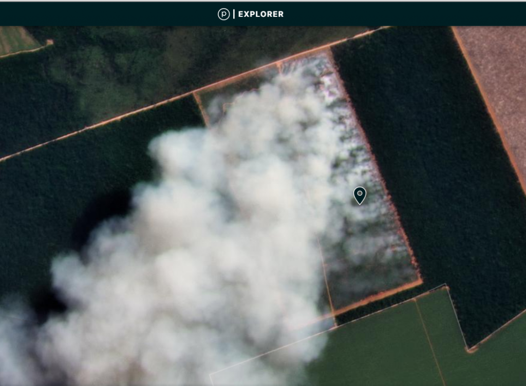
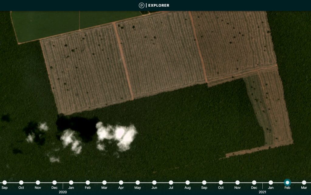
Image 1. Major fire burning recently deforested area in Brazilian Amazon (Mato Grosso). Data: Planet.

We emphasize the following major findings for the Brazilian Amazon:

  • Over half (51%burned recently deforested areas, defined as areas where the forest was previously cleared between 2018 and 2020 prior to burning (Image 1). These fires burned an estimated 1.8 million acres (742,000 hectares), highlighting the massive current deforestation in Brazil.
  • A striking number (41%) were forest fires, defined here as human-caused fires in standing forest. A rough initial estimate suggests that 5.4 million acres (2.2 million hectares) of Amazon forest burned.
  • Over half (52%) occurred in September, followed by August (26%). September was also when we documented a major shift from recently deforested area fires to forest fires.
  • An important number of major fires (13%) occurred within indigenous territories and protected areas. The most impacted were Xingu and Kayapó Indigenous Territories, Jamanxim National Forest, and Nascentes da Serra do Cachimbo Biological Reserve.
  • The vast majority of the major fires (99%) appear to be illegal, occurring after the fire moratoriums established in July.
  • Para (39%) and Mato Grosso (30%) states had the most fires, followed by Amazonas (16%), Rondonia (11%), and Acre (4%).

Bolivian Amazon


Image 2. Major fire in Noel Kempff Mercado National Park, in the Bolivian Amazon. Data: Planet.

We emphasize the following major findings for the Bolivian Amazon:

  • Many of the fires (46%) occurred in savannas.
  • Another 42% of the fires were located in forests, mostly in the dry forests of the Chiquitano. Note, in November there was a major spike in these fires.
  • Importantly, 25% of the major fires were in protected areas. The most impacted were Noel Kempff Mercado National Park (Image 2), Copaibo Municipal Protected Area, Iténez National Park, Keneth Lee Reserve, Rios Blanco y Negro Wildlife Reserve, and Pampas del Río Yacuma Integrated Management Natural Area.
  • Most of the fires occurred in the department of Beni (51%), followed by Santa Cruz (46%).
  • August had the most fires (27%) followed closely by each of September, October, and November (24% each).

Peruvian Amazon


Image 3. Major fire in higher elevation grassland of the Peruvian Amazon. Data: Planet.

We emphasize the following major findings for the Peruvian Amazon:

  • Most of the major fires (56%) burned recently deforested areas. Although the pattern is similar to the Brazilian Amazon, the burned (and previously deforested) areas are much smaller.
  • Most of these fires occurred in three regions, Madre de Dios (40%), Ucayali (21%), and Huánuco (15%).
  • There were also numerous major fires (28%) in higher elevation grasslands across several regions (Image 3). We underestimated the number of these fires because, due to the lack of biomass in these ecosystems, they didn’t always register as a major fire in the app.
  • October had the most fires (49%) followed by September (38%).

*Notes

The data, updated through November 8, is based on our analysis of Amazon Conservation’s novel real-time Amazon Fires Monitoring app. The app displays aerosol emissions as detected by the European Space Agency’s Sentinel-5 satellite. Elevated aerosol levels indicate the burning of large amounts of biomass, defined here as a “major fire”.

Also, check out Mongabay’s real-time Brazilian Amazon fire tracker based on our analysis.

Acknowledgements

The app was developed and updated daily by Conservación Amazónica (ACCA). The data analysis is led by Amazon Conservation in collaboration with SERVIR Amazonia.


Citation

Finer M, Villa L, Vale H, Ariñez A, Nicolau A, Walker K (2020) Amazon Fires 2020 – Recap of Another Intense Fire Year. MAAP: 129.