2019 Impact Report

Dear Friend of the Amazon,

Looking back on 2019, so many moments served as vivid reminders of the important challenges humanity and our planet face. The fires in the Amazon and the global climate emergency were some that stood out to me and highlighted the amazing power we have as a collective force to bring about change. We hope you’ll be inspired by the results we achieved together, shown in our 2019 annual report. Each story here reflects a moment, person, or project that energized us and proved that your contributions are having a real impact.

Now, with the COVID-19 pandemic, our relationship with nature and the need to protect it has never been so important. It’s brought to light how paramount and timely our work is: the health of the forests we protect is directly connected to human wellbeing as well as the general health of our planet.

As we celebrate our 20th anniversary this year, we’re forging ahead with a new strategy to protect the Amazon with a new holistic approach that unites people, science, technology, and innovation to move conservation forward. We hope you’ll join us on this journey!

Sincerely,

John Beavers
Executive Director


Drag your mouse across the pages to flip through the annual report, or click here to view the PDF.
You can also click anywhere on the publication to pull up this menu, where you it gives you the optin to view the report in full screen (1) or see a page overview(2).
(1)Screenshot of how to make report fullscreen (2)Screenshot of how to see report overview

Looking Back: Providing Assistance During the 2019 Amazon Fires

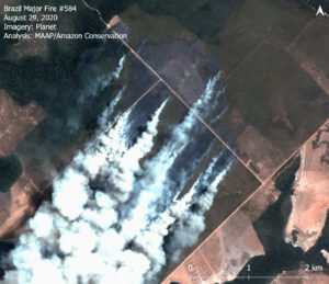
August 2020 just ended its run as a severe Amazon fire month, with 621 major fires being recorded in the Brazilian Amazon alone, with increasing fires being in Peru and 52 major fires in Bolivia as well. The vast majority of the major fires (80%) are burning recently deforested areas, defined here as areas where the forest was previously and recently cleared (between 2018-20) prior to burning. In fact, over a million acres (435,000 hectares) of recently deforested areas burned in 2020.

However, since last year’s fires, we were able to relaunch a real-time fire monitoring app, with improved methodology and the ability to predict fires based on deforestation trends. The new app uses both aerosol and heat data to prioritize large fires (traditional fire alerts use only heat data), and was one of the many initiatives that we were able to undertake with our supporters’ help during last year’s fires season.

Let’s look back at what other assistance we were able to give during the 2019 fire season.

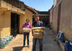
Volunteer holding 50 fire protection vests

Along with this novel app that helps us monitor from the sky, our organization was also helping fight fires on the ground in Bolivia.

As part of our fire management efforts, we worked with several organizations to generate reliable information to implement actions that are helping firefighters and inhabitants of affected areas. We were able to provide communities and governments with fire prevention training and supplies, so that local people could be better prepared and at the forefront of preventing and fighting forest fires.

Donations that we received last year turned into immediate action during the heart of the fire season, enabling us to move quickly to support communities and governments in firefighting and prevention efforts. Using the donations we received, we:

Supplies for volunteers
Supplies for Volunteer Firefighters

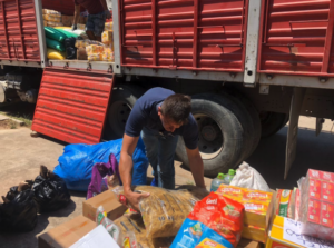
Provided 50 firefighting suits and firefighting tools, as well as water, food, and supplies to more than 100 Bolivian volunteer firefighters and park rangers as they worked together to extinguish the fires.

Supported the protection of and firefighting activities in 6 protected areas that were directly affected by the widespread fires in Bolivia, which cover over 17 million of acres of vulnerable and unique ecosystems.

Provided much-needed supplies and maintenance for the vehicles used to mobilize Bolivian fire brigades and park rangers to where the fires were at their worst, for the entire 3 months of the emergency.

Food Supplies for Volunteer Firefighters and Park Rangers
Food Supplies for Volunteer Firefighters

Created 12 real-time, fact-based satellite reports of the fires across the Amazon (with a special focus on Brazil and Bolivia) – dispelling myths and giving policymakers, government officials, the media, and the general public up-to-date information on what was actually happening on the ground.

Provided drone overflights in Peru to analyze the impact of the fires in the region and report this vital information to local governments and affected communities. 

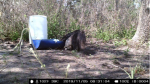
Food for native species who's food sources were destroyed by the fires
Food for native species

Provided food for native species whose food sources were destroyed by the fires.

Advanced our conservation work in the Amazon to ensure the present and future protection of conservation areas and indigenous reserves, that helps governments and local people prevent fires and deforestation from happening in the first place.

We are so grateful for all the support we received last year, and continue to use what was left of donations last year address fires again this year. Additionally, we have improved our real-time fire monitoring app to be more precise, aiding local authorities in detecting and addressing large fires. To support important fire detection and prevention efforts, click here.


Amazon Fire Tracker 2020: Over 500 Illegal Major Fires In Brazilian Amazon

The Brazilian Amazon just passed a grim milestone: Over 500 illegal major fires thus far in 2020.

The other major headline is that, although most fires continue to burn recently deforested areas, we are now seeing an increase in forest fires.

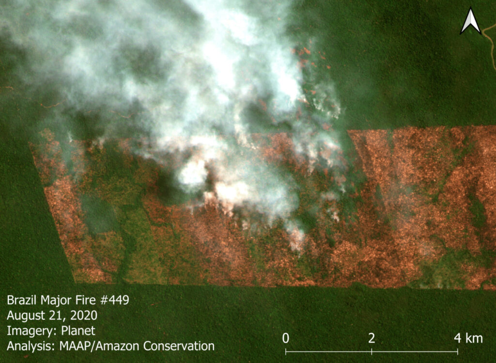
Our Real-time Amazon Fire Monitoring app has detected 504 major fires in the Brazilian Amazon as of August 24 (starting from the first major fire detected on May 28).

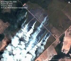
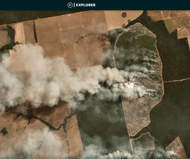
Brazilian Amazon Fire #449, burning both recently deforested area (center) and forest fire (upper center). Data: Planetscope (Planet), MAAP. Click to enlarge.

Some striking stats about this year’s major fires:

  • 97% have occured after the burning moratoriums established in July and are illegal.
  • 85% have occurred in August. Thus, the fire season has been accelerating.
  • 83% have burned recently deforested areas. Thus, the fires are actually a smoking indicator of the rampant deforestation.
  • 12% have been Forest Fires. This number marks a major increase from previous estimate as the fire season intensifies.
  • 4% have occurred in Protected Areas or Indigenous Territories.
  • 856,000 acres (353,000 hectares) have burned in the recently deforested areas fires.
  • 165,000 acres (66,000) have burned in the forest fires.


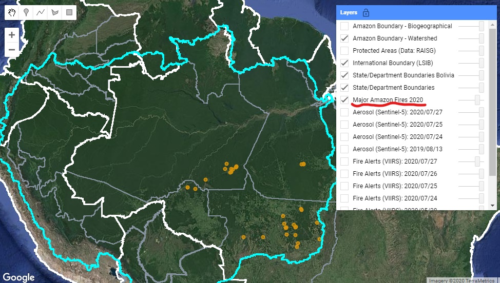
Base Map

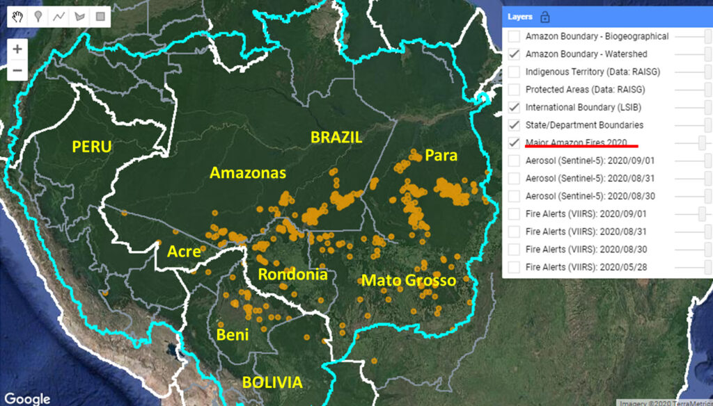
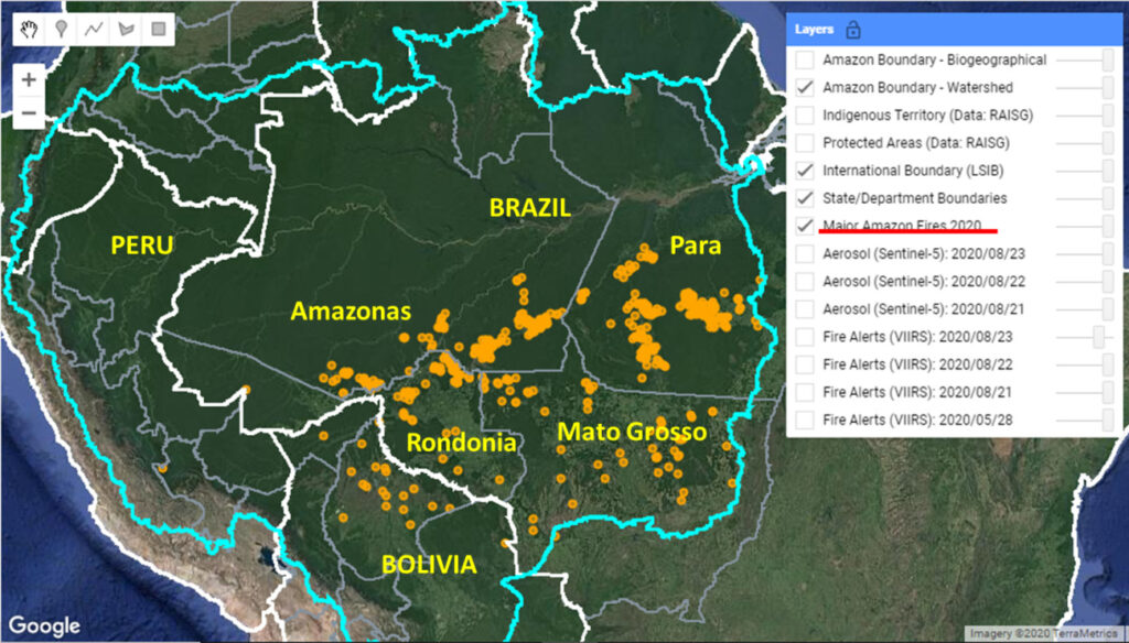
The Base Map is a screen shot of the app’s “Major Amazon Fires 2020” layer. The majority of the major fires in the Brazilian Amazon have been in the states of Pará (42%) and Amazonas(31%), followed by Mato Grosso (13%) and Rondônia (13%). Note we are also now seeing an increase in major fires in the Bolivian Amazon, particularly savannah fires, and that will be the subject of a future report.

Base Map. Major Amazon Fires 2020. Data: MAAP.


*Notes and Methodology

The app specializes in filtering out thousands of the traditional heat-based fire alerts to prioritize only those burning large amounts of biomass (defined here as a major fire).

In a novel approach, the app combines data from the atmosphere (aerosol emissions in smoke) and the ground (heat anomaly alerts) to effectively detect and visualize major Amazon fires.

When fires burn, they emit gases and aerosols. A new satellite (Sentinel-5P from the European Space Agency) detects these aerosol emissions. Thus, the major feature of the app is detecting elevated aerosol emissions which in turn indicate the burning of large amounts of biomass. For example, the app distinguishes small fires clearing old fields (and burning little biomass) from larger fires burning recently deforested areas or standing forest (and burning lots of biomass).

We define “major fire” as one showing elevated aerosol emission levels on the app, thus indicating the burning of elevated levels of biomass. This typically translates to an aerosol index of >1 (or cyan-green to red on the app). To identify the exact source of the elevated emissions, we reduce the intensity of aerosol data in order to see the underlying terrestrial heat-based fire alerts. Typically for major fires, there is a large cluster of alerts. The major fires are then confirmed, and burn areas estimated, using high-resolution satellite imagery from Planet Explorer.

See MAAP #118 for additional details on how to use the app.

No fires permitted in the Brazilian state of Mato Grosso after July 1, 2020. No fires permitted in all of Brazilian Amazon after July 15, 2020. Thus, we defined “illegal” as any major fires detected after these respective dates.

A major fire may be classified as burning across multiple land categories (for example, both recently deforested area and surrounding forest fire) so those percentages do not total 100%.

There was no available Sentinel-5 aerosol data on July 4, 15, and 26.

Acknowledgements

This analysis was done by Amazon Conservation in collaboration with SERVIR Amazonia.

Citation

Finer M, Vale H, Villa L, Nicolau A (2020) Over 500 Illegal Major Fires in Brazilian Amazon. MAAP.

MAAP #123: Detecting Illegal Logging In The Peruvian Amazon

Image 1. Example of a 2019 logging road with signs of illegality. Data: Planet.

In the Peruvian Amazon, the widespread illegal logging is difficult to detect with satellites because it is selective for high-value species (not clearcutting).

It is possible, however, to detect the associated logging roads.

In this report, we present a novel technique to identify illegal logging: analyze new logging roads in relation to detailed land use data available from government agencies.

Thus, our new method detects the crime in real-time and preventive action is still possible. This is important because when an intervention against illegal logging normally occurs, stopping a boat or truck with illegal timber, the damage is done.

This analysis has two parts. First, we identified the new logging roads built in the Peruvian Amazon during 2019, updating our previous work for 2015-18 (see Base Map).

Second, we analyzed the new logging road data in relation to governmental land use information in order to identify possible illegality.

This data is from 2019, but we are now applying this technique in real time during 2020.
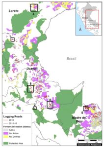
 

Base Map. 2019 Logging roads, in relation to 2015-18 logging roads. Data: MAAP.

Logging Roads 2019

The Base Map illustrates the location of logging roads built in the Peruvian Amazon during the last 5 years.

Previously (MAAP #99), we documented the construction of 3,300 kilometers of logging roads between 2015 and 2018.

Here, we estimate the construction of an additional 1,500 kilometers in 2019 (see red).

Note that forest roads are mainly concentrated in the Ucayali, Madre de Dios and Loreto regions.

Below, we show three types of possible illegality that detected in 2019:

  • Logging roads in areas without forestry concessions or permits (Cases 1-2).
    .
  • Logging roads in existing forest concessions, but whose current status is defined as “Non-Active or Undefined” (Cases 3-5).
    .
  • Logging roads in Native Communities (Case 6).


Cases of Possible Illegality

Logging roads in areas without forestry concessions or permits

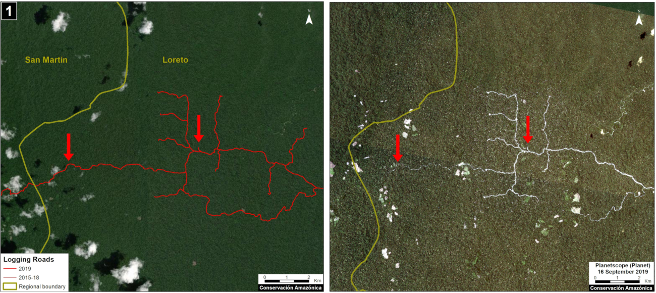
Case 1. We detected the opening of a new logging road network (55 km) in an area without forestry concessions or permits, between the limits of the Loreto and San Martín regions. The image shows the digitized logging roads (red, left panel), and non-digitized satellite image (right panel). The arrows provide reference points between panels.
Case 1. Data: MAAP, Planet. Click to enlarge.


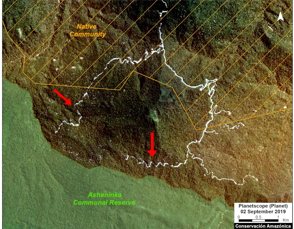
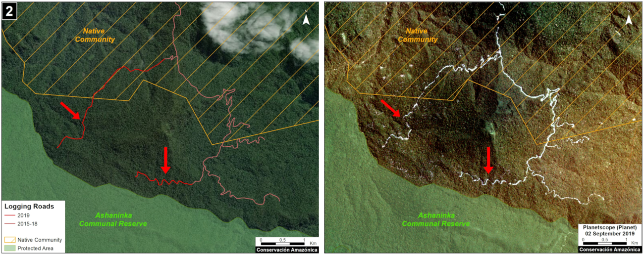
Case 2. We detected the construction of a new logging road network (5.8 km) in the buffer zone of Asháninka Communal Reserve, reaching only 300 meters from the protected area. The image shows the digitized logging roads (red, left panel), and non-digitized satellite image (right panel). The arrows provide reference points between panels.
Case 2. Data: MAAP, Planet, IBC, SERNANP. Click to enlarge.


Logging roads in existing forest concessions, but whose current state is labelled as “Non-Active or Undefined” 

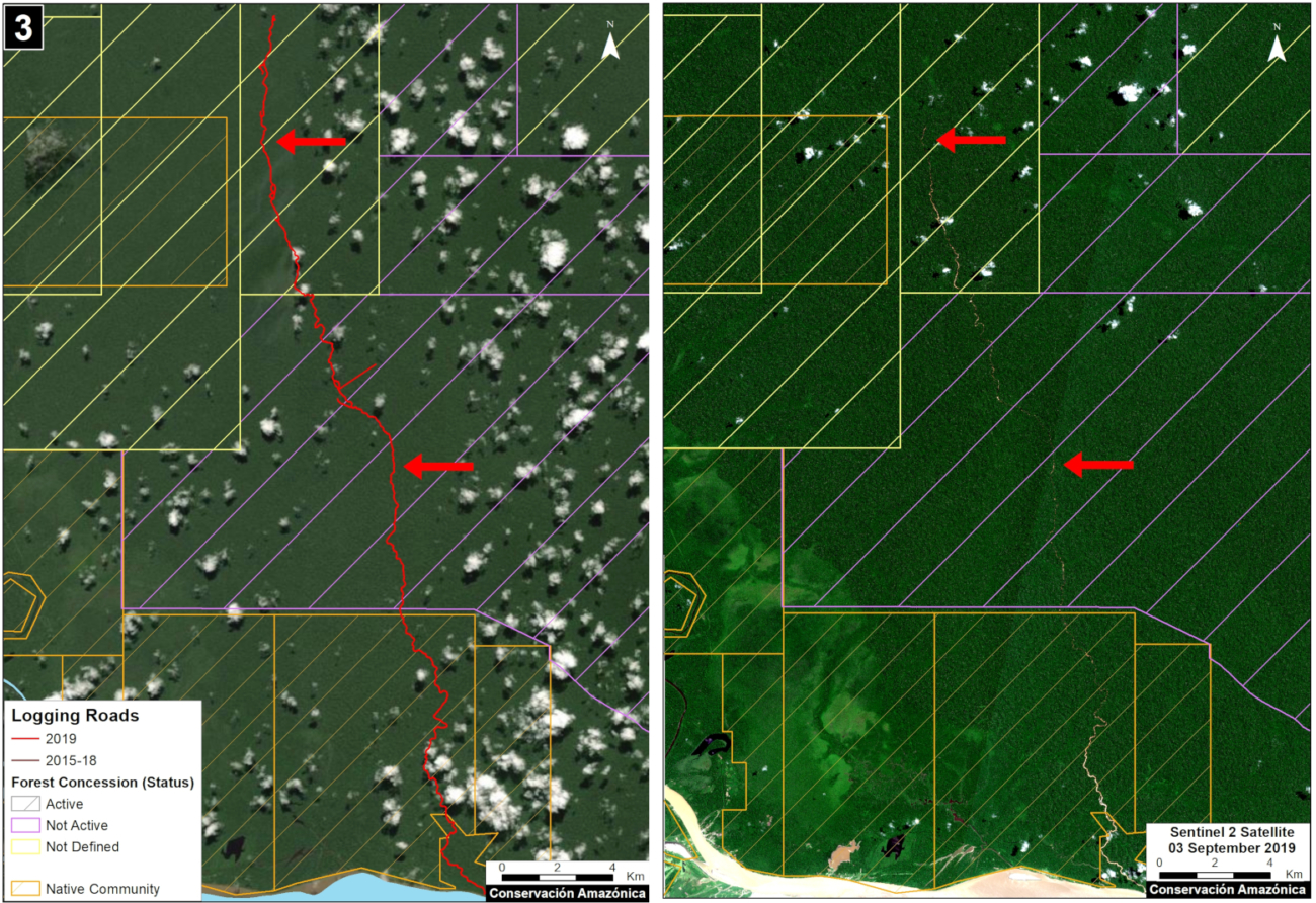
Case 3. We detected the construction of a new logging road (45.3 km) that crosses a native community and reaches a forest concession whose status is defined as “Undefined,” in the Loreto region just north of Pacaya Samiria National Reserve. The image shows the digitized logging roads (red, left panel), and non-digitized satellite image (right panel). The arrows provide reference points between panels.
Case 3. Data: MAAP, ESA, IBC, SERFOR. Click to enlarge.


Case 4. We detected the construction of a new logging road network (53.2 km), of which nearly half (21.4 km) crosses a forest concession whose status is defined is “Non Active”, near the town of Sepahua in the Ucayali region. The image shows the digitized logging roads (red, left panel), and non-digitized satellite image (right panel). The arrows provide reference points between panels.
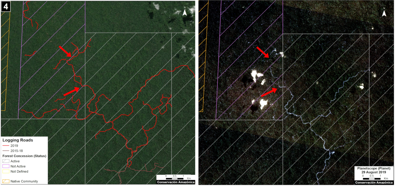
Case 4. Data: MAAP, Planet, IBC, SERFOR. Click to enlarge.


Case 5. We detected the construction of a new logging road (17.7 km) in a forestry concession whose current status is defined as “Non Active,” in the Madre de Dios region. The image shows the digitized logging roads (red, left panel), and non-digitized satellite image (right panel). The arrows provide reference points between panels.
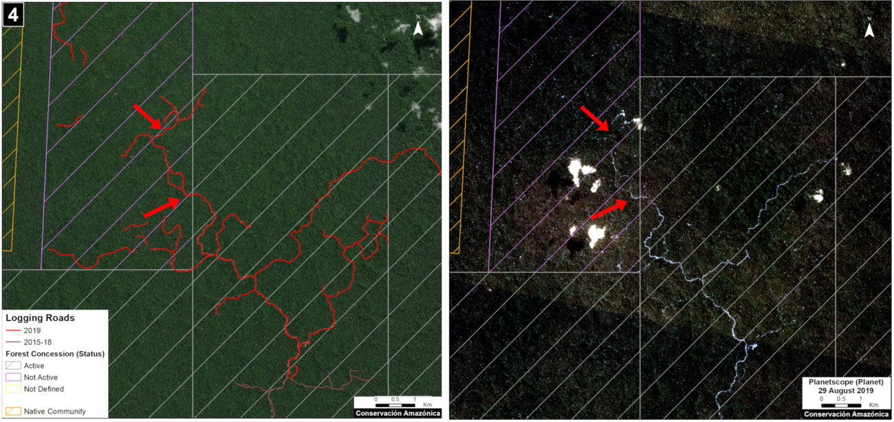
Case 5. Data: MAAP, ESA, IBC, SERFOR. Click to enlarge.


Logging roads in Native Communities

Case 6. We detected the construction of a logging road (23.4 km) within an indigenous community in the Ucayali region. We did not find evidence of a permit for this activity. The image shows the digitized logging roads (red, left panel), and non-digitized satellite image (right panel). The arrows provide reference points between panels.
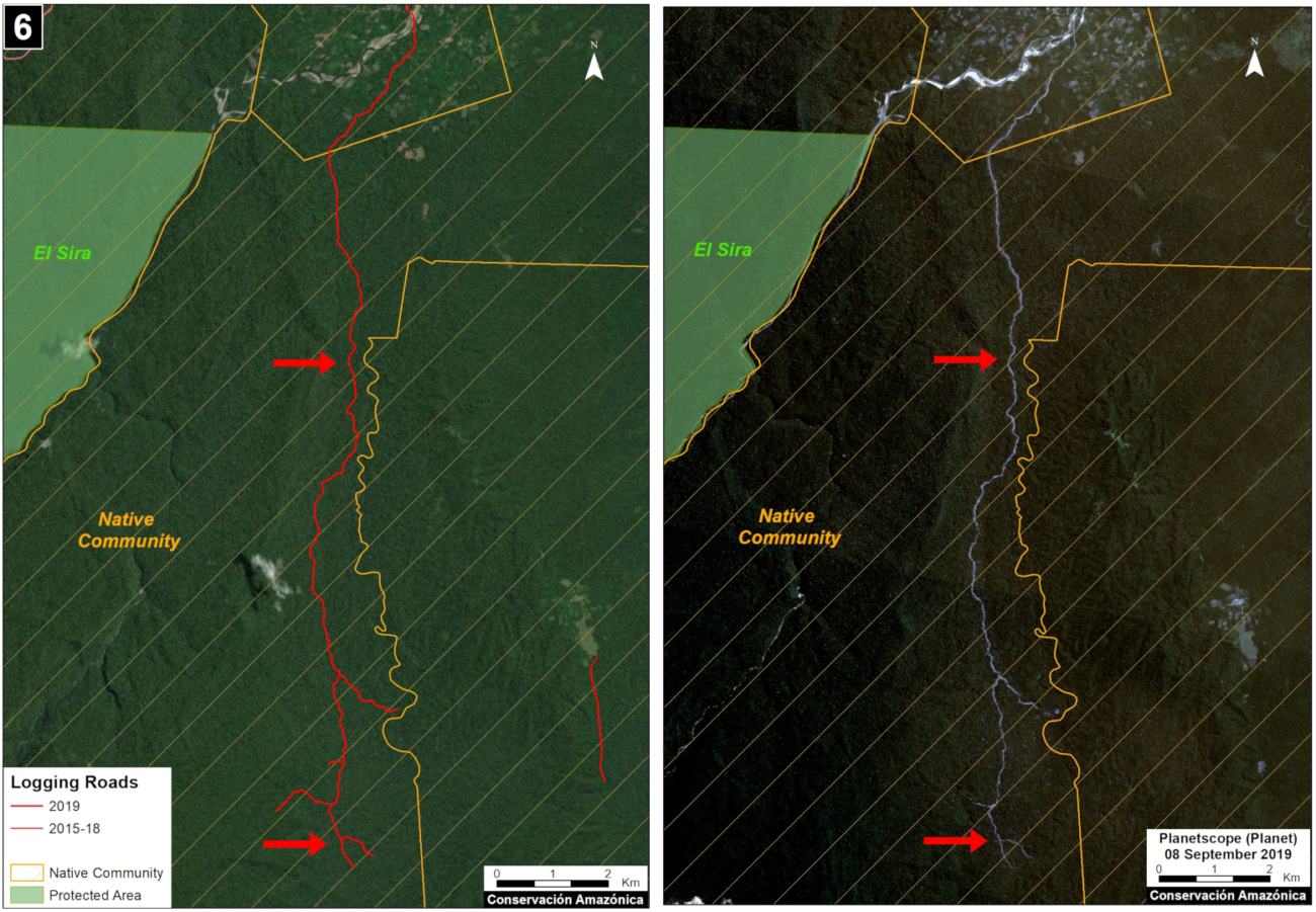
Case 6. Data: MAAP, Planet, SERNANP, IBC, SERFOR. Click to enlarge.


Methodology

Our analysis included two main steps:

The first step consisted of evaluating linear patterns in the 2019 early warning and final forest loss data, available from Global Forest Watch (data from the University of Maryland) and Geobosques (data from the Peruvian Ministry of the Environment). From the linear patterns, we distinguished between logging access roads and other types of roads and highways. Logging roads tend to have linear patterns that branch into the interior of the forest where the commercial timber is found. Other types of roads have a more defined destination, such as towns or farms. Once logging roads were identified, we downloaded the associated high-resolution imagery (3 meters) from Planet Explorer and digitized the roads in ArcGIS. During this process, additional logging roads detected in the high resolution images were also digitized.

The second step focused on the legality analysis. The new logging road data were overlaid with other types of land use information, such as forestry concessions on the GeoSERFOR portal (SERFOR), permits and concessions on the SISFOR portal (OSINFOR), indigenous communities (IBC 2019), protected areas (SERNANP), population centers (INEI 2019), and official road networks (MTC 2018). For example, as shown above, this process identified logging roads near protected areas, within indigenous communities, and within non-active forest concessions.

We analyzed information on several websites now available from national and regional authorities, such as SISFOR (OSINFOR), GEOSERFOR (SERFOR), and IDERs (Spatial Data Infrastructure of Regional governments). These new resources provide valuable information, however may have limitations in ability to constantly update information on the status of concessions and forest permits, especially from regional governments.


References

Planet Team (2017). Planet Application Program Interface: In Space for Life on Earth. San Francisco, CA. https://api.planet.com


Acknowledgments

We thank R. Valle (OSINFOR), A. Felix (DAI), D. Suarez (ACCA), and G. Palacios for their helpful comments on this report.

This report was conducted with technical assistance from USAID, via the Prevent project. Prevent is an initiative that, over the next 5 years, will work with the Government of Peru, civil society, and the private sector to prevent and combat environmental crimes in Loreto, Ucayali and Madre de Dios, in order to conserve the Peruvian Amazon.

This publication is made possible with the support of the American people through USAID. Its content is the sole responsibility of the authors and does not necessarily reflect the views of USAID or the US government.

Citation

Finer M, Paz L, Novoa S, Villa L (2020) Detecting Illegal Logging in the Peruvian Amazon. MAAP: 123.
Amazon Fire Tracker 2020: Images Of The Brazilian Amazon Fires

Images of the 2020 Brazilian Amazon FireOur innovative new app for Real-time Amazon Fire Monitoring has now detected over 350 major fires in the Brazilian Amazon this season.*

Specifically, we have detected 365 major fires as of August 17, since the first major fire detected on May 28.

The fire season is accelerating, as 79% of the major fires have occured in August.

Below, we present a series of satellite images showing key examples from August 2020.

We highlight our key finding that the vast majority of major fires (88%burned recently deforested areas covering 557,000 acres (226,000 hectares). Thus, the fires are actually a striking indicator of the rampant deforestation currently threatening the the Brazilian Amazon.

We have detected 4 Forest fires (1% of the major fires) covering 2,790 acres (1,130 hectares) and 3 savanna fires covering 38,000 acres (15,000 hectares). The rest of the major fires are burning older agricultural areas.

Other key findings include:

  • The vast majority of the fires (96%) are illegal, occuring past the 120 day moratorium established in July.
  • At least 18 of the major fires have been in protected areas or indigenous territories.
  • Most of the fires (70%) have occurred in two departments: Amazonas and Para. Mato Grosso and Rondonia each account for 15%.

We have detected an additional 10 major fires in the Bolivian Amazon, and that will be the feature of a future report.


Images of the 2020 Brazilian Amazon Fires

1) Fires burning recently deforested areas

Brazilian Amazon Fire #338 (August 16, 2020)

Brazilian Amazon Fire #338 (August 16, 2020)


Brazilian Amazon Fire #335 (August 16, 2020)

Brazilian Amazon Fire #335 (August 16, 2020)


Brazilian Amazon Fire #233 (August 11, 2020)Brazilian Amazon Fire #233 (August 11, 2020)


Brazilian Amazon Fire #230 (August 11, 2020)

Brazilian Amazon Fire #230 (August 11, 2020)


Brazilian Amazon Fire #221 (August 11, 2020)

Brazilian Amazon Fire #221 (August 11, 2020)

Brazilian Amazon Fire #202 (August 10, 2020)

Brazilian Amazon Fire #202 (August 10, 2020)


Brazilian Amazon Fire #188 (August 9, 2020)

Brazilian Amazon Fire #188 (August 9, 2020)


Brazilian Amazon Fire #124 (August 6, 2020)

Brazilian Amazon Fire #124 (August 6, 2020)


Brazilian Amazon Fire #110 (August 4, 2020)

Brazilian Amazon Fire #110 (August 4, 2020)


Brazilian Amazon Fire #109 (August 4, 2020)

Brazilian Amazon Fire #109 (August 4, 2020)


Brazilian Amazon Fire #76 (August 1, 2020)

Brazilian Amazon Fire #76 (August 1, 2020)


2) Forest Fires 

Brazilian Amazon Fire #218, August 2020

Brazilian Amazon Fire #218, August 2020


Brazilian Amazon Fire #195, August 2020

Brazilian Amazon Fire #195, August 2020


3) Grassland (Savanna) Fires 

Brazilian Amazon Fire #219, August 2020

Brazilian Amazon Fire #219, August 2020


*Notes and Methodology

The app specializes in filtering out thousands of the traditional heat-based fire alerts to prioritize only those burning large amounts of biomass (defined here as a major fire).

In a novel approach, the app combines data from the atmosphere (aerosol emissions in smoke) and the ground (heat anomaly alerts) to effectively detect and visualize major Amazon fires.

When fires burn, they emit gases and aerosols. A new satellite (Sentinel-5P from the European Space Agency) detects these aerosol emissions. Thus, the major feature of the app is detecting elevated aerosol emissions which in turn indicate the burning of large amounts of biomass. For example, the app distinguishes small fires clearing old fields (and burning little biomass) from larger fires burning recently deforested areas or standing forest (and burning lots of biomass).

We define “major fire” as one showing elevated aerosol emission levels on the app, thus indicating the burning of elevated levels of biomass. This typically translates to an aerosol index of >1 (or cyan-green to red on the app). To identify the exact source of the elevated emissions, we reduce the intensity of aerosol data in order to see the underlying terrestrial heat-based fire alerts. Typically for major fires, there is a large cluster of alerts. The major fires are then confirmed, and burn areas estimated, using high-resolution satellite imagery from Planet Explorer.

See MAAP #118 for additional details.

No fires permitted in the Brazilian state of Mato Grosso after July 1, 2020. No fires permitted in all of Brazilian Amazon after July 15, 2020. Thus, we defined “illegal” as any major fires detected after these respective dates.

There was no available Sentinel-5 aerosol data on July 4, 15, and 26.


Acknowledgements

This analysis was done by Amazon Conservation in collaboration with SERVIR Amazonia.

Citation

Finer M, Nicolau A, Vale H, Villa L, Mamani N (2020) Amazon Fire Tracker 2020: Images of the Brazilian Amazon Fires. MAAP.

Amazon Fire Tracker 2020: Over 200 Major Fires As Of Aug 10

Photo of Brazil Fire 76 on July 31 2020Our innovative new app for Real-time Amazon Fire Monitoring has detected over 200 major fires in 2020.

The app specializes in filtering out thousands of the traditional heat-based fire alerts to prioritize only those burning large amounts of biomass (defined here as a major fire).*

Our key findings include:

  • We have detected 227 major Amazon fires (Brazil 220, Bolivia 6; Peru 1), as of August 10.
    ,
  • The vast majority of major fires have been in the Brazilian Amazon, where a strikingly high number (85%) have burned recently deforested areas. Thus, the fires are actually a smoking indicator of the rampant deforestation now in Brazil.
    k
  • In Brazil, we have detected two forest fires, but this risk increases as we get deeper into the dry season. The rest of the fires have been on older fields.
    l
  • In Brazil, the vast majority (94%) of the major fires have been illegal, in violation of the state and national fire moratoriums established in July. In fact, despite the moratoriums, the number of major fires is accelerating: 143 so far in August following 77 in May through July.
    m
  • In Brazil, 14 of the fires have been in Protected Areas.
    k
  • In the Bolivian and Peruvian Amazon, we have recently started detecting fires in the drier ecosystems (savannahs and grasslands).

See below for a more detailed breakdown of the results.


Additional Results

The Base Map is a screen shot of the app’s “Major Amazon Fires 2020” layer.

The vast majority of the fires have been in the Brazilian AmazonPará (37%) and Amazonas (39%), followed by Mato Grosso (17%) and Rondônia (8%).

Importantly, the vast majority of the major fires in the Brazilian Amazon (85%) have burned recently deforested areas (cleared between 2018 and 2020) covering 280,000 acres (113,000 hectares). Thus, we argue that the central issue is actually deforestation and the fires are actually a smoking indicator of this forest loss.

We have detected the first two forest fires, burning 388 acres (1,447 hectares) in Mato Grosso and Para.

The rest of the major fires have been on older cattle or agricultural lands (deforested prior to 2018).

The most impacted protected areas are Jamanxim and Altamira National Forests in Pará. We emphasize, however, that these fires were burning recently deforested areas (not forest fires) and so, again, the primary issue is deforestation.

In Brazil, the vast majority of the major fires (94%) appear to be illegal as they violate the state and national government mandated fire moratoriums established in July. In fact, despite the moratoriums, the number of major fires is accelerating: 143 so far in August, following 64 in July, 12 in June, and the first one in May.

In the Bolivian Amazon, we have recently started detecting fires in the savannahs in the department of Beni. We also detected one fire in a recently deforested area in the Santa Cruz department.

In the Peruvian Amazon, we have recently started detecting fires in the upper elevation grasslands. The biggest one was actually within a protected area (Otishi National Park). There have also been smaller grassland fires near the buffer zone of upper Manu National Park.


Key Examples of 2020 Fires

Overall our key finding is that most major Brazilian Amazon fires are burning recently deforested areas, and not raging forest fires. Below is a series of satellite image time-lapse videos showing examples of recent deforestation followed by a major 2020 fire.


Brazilian Amazon Fire #54, July 2020


Brazilian Amazon Fire #59, July 2020


Brazilian Amazon Fire #76, July 2020


Brazilian Amazon Fire #110, August 2020


*Notes and Methodology

In a novel approach, the app combines data from the atmosphere (aerosol emissions in smoke) and the ground (heat anomaly alerts) to effectively detect and visualize major Amazon fires.

When fires burn, they emit gases and aerosols. A new satellite (Sentinel-5P from the European Space Agency) detects these aerosol emissions. Thus, the major feature of the app is detecting elevated aerosol emissions which in turn indicate the burning of large amounts of biomass. For example, the app distinguishes small fires clearing old fields (and burning little biomass) from larger fires burning recently deforested areas or standing forest (and burning lots of biomass).

We define “major fire” as one showing elevated aerosol emission levels on the app, thus indicating the burning of elevated levels of biomass. This typically translates to an aerosol index of >1 (or cyan-green to red on the app). To identify the exact source of the elevated emissions, we reduce the intensity of aerosol data in order to see the underlying terrestrial heat-based fire alerts. Typically for major fires, there is a large cluster of alerts. The major fires are then confirmed, and burn areas estimated, using high-resolution satellite imagery from Planet Explorer.

See MAAP #118 for additional details.

No fires permitted in the Brazilian state of Mato Grosso after July 1, 2020. No fires permitted in all of Brazilian Amazon after July 15, 2020. Thus, we defined “illegal” as any major fires detected after these respective dates.

There was no available Sentinel-5 aerosol data on July 4, 15, and 26.


Acknowledgements

This analysis was done by Amazon Conservation in collaboration with SERVIR Amazonia.

Citation

Finer M, Nicolau A, Villa L (2020) 200 Major Amazon Fires in 2020: Tracker Analysis. MAAP.

153,000 Acres Of Brazil Nut Forests Protected by Amazon Conservation and Google

 Brazil nut concessionaires walking in forestAmazon Conservation’s sister organization Conservación Amazónica – ACCA, with support from Google.org, just finished up a two-year initiative that trained community members to use cutting-edge satellite and field technologies to combat deforestation in the southern Peruvian Amazon, now protecting over 150,000 acres of lowland forests.
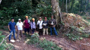
This initiative trained 75 Brazil nut harvesters and their families in forest monitoring technologies, which will help them safeguard forests to be used for sustainable purposes. Preventing deforestation of natural resources is not only environmentally important, but also economically, as the productive forests in and around the Madre de Dios area in Peru provide a sustainable and forest-friendly economic income to around 45,000 people, about 20% of the population.

In Peru, local families or associations can be granted a piece of public forests to be used for specific purposes – called a concession – such as harvesting nuts and berries, or for ecotourism. This system prevents acres of forests from falling victim to destructive activities, such as land squatting, illegal logging, or invasions by gold miners. Additionally, concessionaires are required by law to report on illicit activities in their concessions, which is a way the government gets community support to protect large swaths of forests.

Brazil nut concessionairesBefore this program, concessionaires and their communities lacked capacity to monitor these large, remote areas and a way to rapidly and safely report deforestation in their territories. Our innovative methodology of combining real-time satellite imagery analysis and drone field technology (which includes smartapps and other technologies developed by Google) with legal training, gave concessionaires the ability to detect and report deforestation as it happened in their territory. This is a stark contrast from before, when the only way to monitor thousands of acres of forests was through foot patrols that took days to complete. 

Now 75 Brazil nut harvesters and their families are using satellite imagery, early deforestation alerts, and GPS applications on mobile devices to monitor their forests. Among them, 23 individuals successfully obtained their licenses as drone pilots from the Ministry of Transport and Communications’ General Directorate of Civil Aeronautics. This means they can now their entire territory in minutes, without having to face potential risks of confronting dangerous individuals committing environmental crimes or even running into outsiders who might bring diseases like the novel coronavirus into their communities. 

Brazil nut appetizersThrough this program, over 153,000 acres (62,000 hectares) of forests are now monitored and protected with technology by the local people we empowered. Moreover, technological kits were donated to each individual or local association, each containing a drone, a maintenance kit, a laptop and a printer, giving them the knowledge and tools needed to safeguard forests..
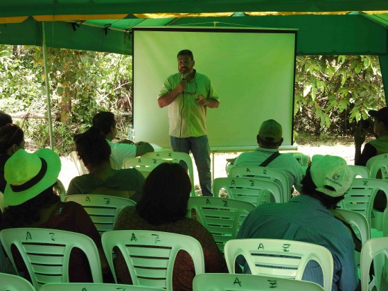
These successes were celebrated with a closing ceremony in the Castaña Amazon Park earlier this year. Local authorities and representatives of local organizations attended, such as the director of the Research Institute of the Peruvian Amazon (IIAP) and members of local harvesting associations. During the ceremony, attendees enjoyed Brazil nut appetizers, while watching presentations about the project, the results achieved, and the collaborators and participants. The event ended with a guided tour of the Brazil Nut Harvesting Center in the Castaña Amazon Park, which is noted as the first living Brazil nut tree park in the world.

Presenter at Brazil Nut Google EventThe project, led by our director of our Southwest Amazon Drone Center, Carlos Castañeda, will continue to provide technical support to maintain the donated drones and training to reinforce what they learned, as well as be available to answer any questions that may arise during monitoring and surveillance of their concessions. Thus, the continuity of the project and its sustainability are ensured.
This Google.org-funded project was the first of its kind nationwide in Peru. After this success, Amazon Conservation continues its mission of conserving the Amazon basin using new technologies. Over the next three years, we hope to strengthen the real-time monitoring of the forests by empowering local people and employing science and technology as a proven way to fight deforestation in the Amazon and create a model for other tropical forests around the world.

Amazon Fire Tracker 2020 – July Update

Recall we recently launched an innovative new app for Real-time Amazon Fire Monitoring (see MAAP #118 for details).

In a novel approach, the app combines data from the atmosphere (aerosol emissions in smoke) and the ground (heat anomaly alerts) to effectively detect and visualize major Amazon fires.

The app specializes in filtering out thousands of the heat-based fire alerts to prioritize only those burning large amounts of biomass and thus emitting elevated levels of aerosol (defined here as a major fire).*

Example of a major fire in the Brazilian Amazon burning recently deforested area. Brazil major fire #54, July 30, Mato Grosso. Image: Planetscope (Planet).

As of the end of July, we have detected 77 major Amazon fires thus far in 2020, all in Brazil.

In summary, 84% of the major fires are burned recently deforested areas and 83% were illegal (in violation of fire moratoriums). We detected the first forest fire on the last day of the month.

We have started detecting large and uncontrolled fires in the drier ecosystems of Bolivia, but outside the Amazon watershed.

See below for a more detailed overview of the 2020 Amazon fire season thru the end of July.


Key Results

The Base Map is a screen shot of the app’s “Major Amazon Fires 2020” layer.

Base Map. Screen shot of the app’s “Major Amazon Fires 2020” layer.

As noted above, we have detected 77 major Amazon fires thus far in 2020, all in Brazil.

The first major fire was detected on May 28 in the state of Mato Grosso in southeastern Brazilian Amazon (see MAAP #118). This event was followed by 12 major fires in June, all in Mato Grosso (see Fire Tracker #12).

The number of major fires in Mato Grosso decreased in July, suggesting the state’s new fire moratorium (starting July 1) may be working.

Starting in mid-July, the major fire activity shifted to the surrounding Brazilian states of Amazonas, Rondônia and Pará. This shift coincided with national fire moratorium (starting July 15), indicating it has not been as effective.

Overall, most of the major fires (83%) appear to be illegal as they violate the state and national government mandated fire moratoriums established in July.

Importantly, most of the major fires (84%) have burned recently deforested areas (deforested 2018-20) covering 108,000 acres (44,000 hectares). See MAAP #113 for more on this important point in regards to the 2019 fires.

We detected the first forest fire on the last day of the month. It burned 388 acres (157 hectares).

The other major fires have been in older cattle or agricultural areas (deforested pre 2018).

We have started detecting large and uncontrolled fires in the drier ecosystems of Bolivia, but outside the Amazon watershed.


Key Examples of 2020 Fires

Overall our key finding is that most major Brazilian Amazon fires are burning recently deforested areas, and not raging forest fires. Below is a series of four satellite images time-lapse videos showing examples of recent deforestation (2019) followed by a major 2020 fire burning lots of biomass that was detected by the app.


Brazilian Amazon Fire #1, May 2020

Brazilian Amazon Fire #4, June 2020


Brazilian Amazon Fire #12, June 2020

Brazilian Amazon Fire #18, July 2020

Brazilian Amazon Fire #54, July 2020

*Notes and Methodology

When fires burn, they emit gases and aerosols. A new satellite (Sentinel-5P from the European Space Agency) detects these aerosol emissions. Thus, the major feature of the app is detecting elevated aerosol emissions which in turn indicate the burning of large amounts of biomass. For example, the app distinguishes small fires clearing old fields (and burning little biomass) from larger fires burning recently deforested areas or standing forest (and burning lots of biomass).

We define “major fire” as one showing elevated aerosol emission levels on the app, thus indicating the burning of elevated levels of biomass. This typically translates to an aerosol index of >1 (or cyan-green to red on the app). To identify the exact source of the elevated emissions, we reduce the intensity of aerosol data in order to see the underlying terrestrial heat-based fire alerts. Typically for major fires, there is a large cluster of alerts. The major fires are then confirmed, and burn areas estimated, using high-resolution satellite imagery from Planet Explorer.

No fires permitted in the Brazilian state of Mato Grosso after July 1, 2020. No fires permitted in all of Brazilian Amazon after July 15, 2020. Thus, we defined “illegal” as any major fires detected after these respective dates.

There was no available Sentinel-5 aerosol data on July 4, 15, and 26.

Acknowledgements

This analysis was done by Amazon Conservation in collaboration with SERVIR Amazonia.

Citation

Finer M, Nicolau A, Villa L (2020) Amazon Fire Tracker 2020 – July Update. MAAP.

Bringing Climate Resilience to Local Communities

For the past year our team in Bolivia and Peru have been working with EUROCLIMA+, an initiative of the European Commission focused on combating climate change in Latin America. We are working with local communities to pilot climate change resilience in their sustainable use of forest resources.

Promoting sustainable forest resources is important for keeping forests standing, and an initiative that we have been expanding for many years now. The Amazon rainforest is full of economically valuable products, such as the Brazil nuts and açaí berries, which are important sources of income for local communities. These fruits can only grow in standing forests, and cannot survive in a monoculture or farmed operation setting. 


An Economic Essential

Luis Arteaga, our Technical Director in Bolivia, coordinates this project. His team works in the northern part of Bolivia, where local communities heavily depend on these forest goods to make a living. “Almost all the families dedicate themselves to harvesting forest fruits, mainly the Brazil nut, which is their main economic activity.” 

Noting the ecological makeup of the area, one can see why: the northern municipality of the Santa Rosa del Ábuna conservation area has the highest concentration of Brazil nut trees in the department of Pando, Bolivia. These nuts generate up to 90% of local families’ overall income, and although harvesting is a job that requires a lot of dedication and back-breaking work, it generates important opportunities for commercialization and sustainable forest management. Luis puts it simply, “If Brazil nuts didn’t exist or didn’t grow in these forests, they would have already been cut down for another economic activity.” 

bags of brazil nutsTying the importance of conservation of these forests not only to climate change but also to economic sustainability of local and global economies is vital for countries and communities to see the value of forests. In fact, our area of work in Bolivia holds 85% of the Brazil nut production in the world, and keeping those forests standing through sustainable activities will have a significant impact in the fight against deforestation and carbon emissions.


Confronting Climate Change

A key aspect of our work with EUROCLIMA+ is recognizing how these sustainable forest economies help mitigate the effects of climate change on communities and on the planet, which hadn’t previously been as much on peoples’ minds. This pilot work is also helping local communities become aware of how climate is changing the forests on which they depend, so they can plan for their long-term, sustainable use, without needing to turn to destructive practices like timber extraction and cattle ranching if a harvesting season is affected by global warming. This involves not only making sure we have healthy forests, but also helping communities diversify their source of income sustainably, such as harvesting other complementary forest products like açaí berries and sustainably farming paiche fish. 

“In my opinion,” Luis notes, “one important advancement is that we are learning how climate change has impacted, is impacting, and will impact this vital bi-national region of the Amazon in Peru and Bolivia. Working with EUROCLIMA+ has taught us to use the climate lens to think about all of our future conservation work as well, and this is a good step forward.”

The Escazú Agreement: Internationalizing the Amazon?

Populism and nationalism in politics are two sides of the same coin.

By: Enrique Ortiz, Amazon Conservation Board Member. (Original article published in El Comercio. See here.)

Photo of Enrique Ortiz, author of the articleThe Escazú Agreement, a regional agreement on access to information, public participation and access to justice in environmental matters in Latin America and the Caribbean whose ratification is soon to be debated in Congress, has generated an intense reaction and discussion. There is a sector that affirms that this agreement would attempt against our sovereignty in the Amazon. Considering that if this agreement is ratified, the important decisions for the economic development of the country would remain in the hands of international spheres. On the other hand, others consider that such an agreement leads to improved information flow and citizen participation. Both are necessary for the development of the country, particularly in Peru where social and environmental conflicts have paralyzed many important works for the economy. Understanding the scope of the agreement and its true implications is crucial for the future of Peru.

The Escazú Agreement stipulates that the signatory countries undertake to comply with a series of mechanisms for transparency of information, consultation, decision making processes, protection of environmental defenders and conflict resolution related to projects that may affect the environment.

How can the Escazú Agreement threaten national sovereignty, and in particular, with our Amazon? To begin with, this is a Latin American regional agreement, which has been signed by 22 democratic nations (including those Amazonian), and so far, has been ratified by 9 of them. The agreement clearly states that decisions are the affairs of each country, within their own regulatory frameworks.  It also stipulates that in cases where the conflict is between States, these – and only under a bilateral agreement – can be submitted to arbitration by the International Court of The Hague, as an international instance. That court does not have jurisdiction for internal affairs of a country, such as those between private, communities and the State. The resolution of controversies within a country is another matter, and only after exhausting the national justice mechanisms, they can be resolved by resorting to international bodies, which have nothing to do with the Escazú agreement.

There is a fear that said agreement will hinder important development projects for the country, or for a specific interest group. And it is argued that this is particularly important in times when we urgently need an economic revival. And it is true, we need development plans, but those that are economically, socially and environmentally sustainable. Otherwise, we will have more Tía Marías, Congas and other extractive projects stranded in the midst of conflicts with no solution in sight. What is expected, instead, is that the Escazú Agreement has the key to resolve these situations throughout the country, on the coast, the Andes and the Amazon.

Peru has played a very important role in the gestation of this agreement since the Rio+20 United Nations conference in 2012. Our chancellery -for three governments- has promoted the vision and structure of this agreement, as expressed in the Lima Declaration. Furthermore, Peru held the vice-presidency of the negotiating executive committee’s and signed the agreement in September 2018, at the United Nations headquarters. In August 2019, President Martín Vizcarra and his chancellor sent the draft legislative resolution to the then President of Congress, for approval. How can it be that, suddenly, the referred agreement is branded by some as a surrogate that cedes 53% of the country to foreign environmental NGOs, and as a national newspaper denounces on the front page, “do they want to rob us of the Amazon”? Very strange.

Populism and nationalism in politics are two sides of the same coin. Painful examples of this are part of our recent history, and today we are seeing it in Brazil. We want development projects that can advance, that are profitable and that have mechanisms for participation, defense of citizens’ rights, and with a long-term vision, as recommended by the OCDE studies, to which our country wants to access. Vision is a keyword for the bicentennial. Let us keep our eyes open to the opportunities that this agreement can give us.