Deforestation update: Our analysis of deforestation hotspots in the western Amazon

Through Amazon Conservation’s Monitoring of the Andean Amazon Project (MAAP), we identify, analyze, track, and publicize deforestation taking place in the Amazon in real-time using high-tech, satellite imagery. We use this information to make local authorities, policymakers, and the general public aware of what is happening on the ground.

Deforestation update- Our analysis of deforestation hotspots in the western AmazonRecently, we conducted an in-depth analysis of 2018 data on forest cover loss and found that 2.5 million acres were deforested in the western Amazon (Colombia, Peru, Ecuador, Bolivia, and western Brazil) last year. An average of 5 acres was lost per minute to deforestation last year. Our additional analysis indicated that, of this total, 1.9 million acres were primary forests, which play a vital role as carbon sinks, mediators of the global water cycle and cradles of biodiversity. 

The combination of forces driving deforestation varies in each country. Land grabbing, unsustainable agricultural activities and expansion, and gold mining were among the key drivers of deforestation that we identified in this region.  

Read more on our 100th MAAP Report.

MAAP #100: Western Amazon – Deforestation Hotspots 2018 (A Regional Perspective)

For the 100th MAAP report, we present our first large-scale western Amazon analysis: Colombia, Peru, Ecuador, Bolivia, and western Brazil (see Base Map).

We use the new 2018 data for forest cover loss, generated by the  University of Maryland (Hansen et al 2013) and presented by Global Forest Watch.

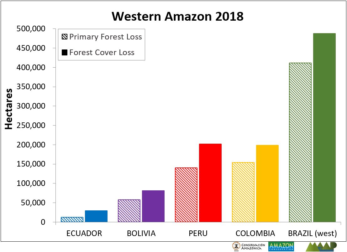
These data indicate 2.5 million acres of forest cover loss in the western Amazon in 2018.*

We conducted an additional analysis that indicates, of this total, 1.9 million acres were primary forest.*

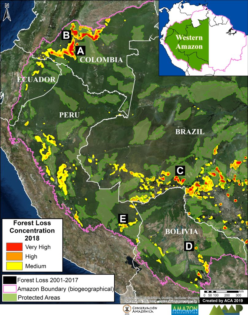
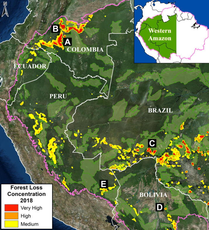
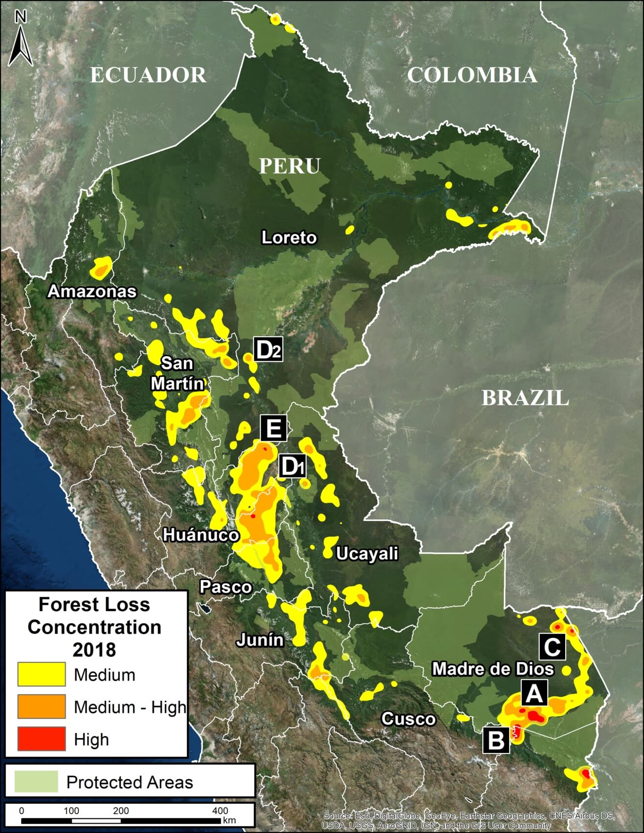
Base Map. Deforestation Hotspots in the western Amazon. Data: Hansen/UMD/Google/USGS/NASA, GFW, SERNANP, SNAP, SINAP, SERNAP, RAISG

To identify deforestation hotspots consistently across this vast landscape, we conducted a kernel density analysis (see Methodology).

The Base Map shows the hotspots in yellow, orange and red, indicating areas with medium, high, and very high forest loss concentrations, respectively.

Next, we focus on five zones of interest (Zooms A-E) in Colombia, Brazil, Bolivia, and Peru. For all images, please click to enlarge.

*Forest Cover Loss: 5 acres per minute. Almost half (49%) occurred in Brazil, followed by Peru (20%), Colombia (20%), Bolivia (8%), and Ecuador (3%). see Annex.

**Primary Forest Loss: 3.5 acres per minute. Over half (53%) occurred in Brazil, followed by Peru (20%), Colombia (18%), Bolivia (7%), and Ecuador (2%). see Annex.


Colombia

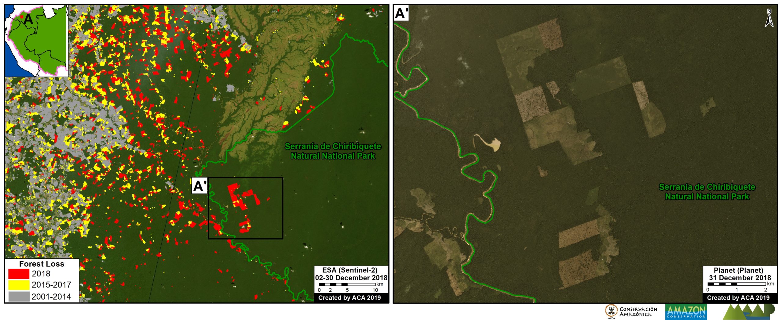
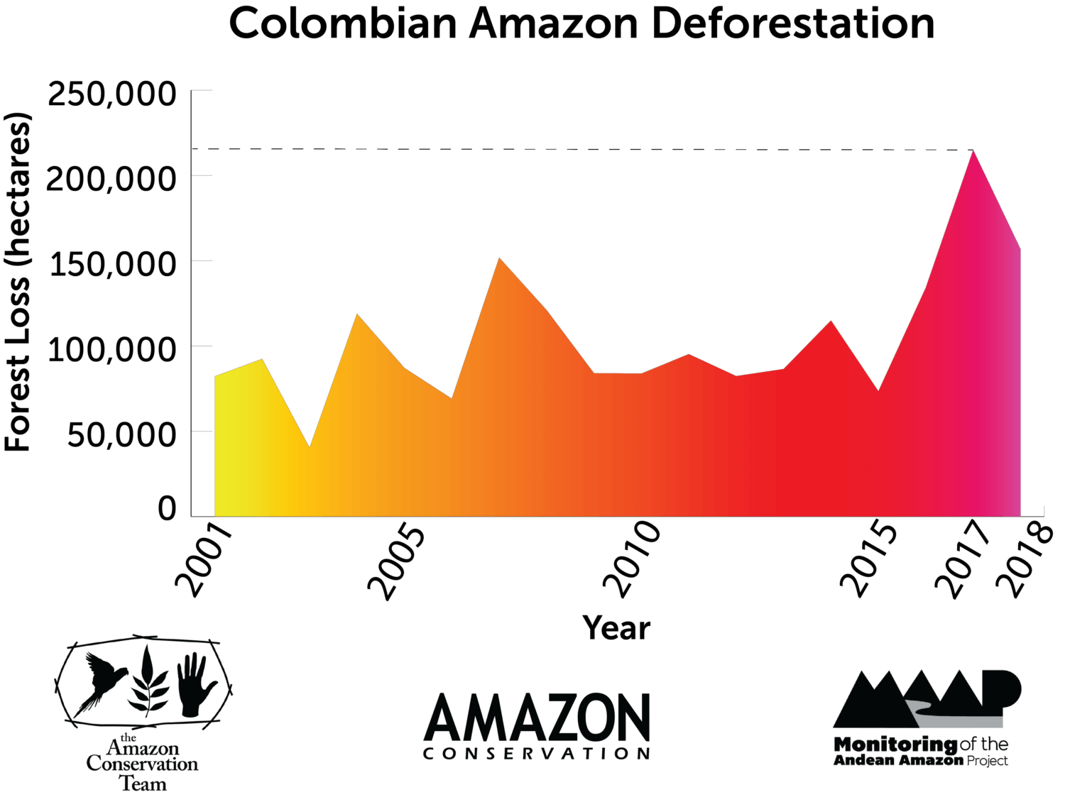
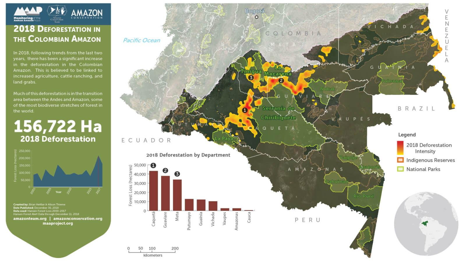
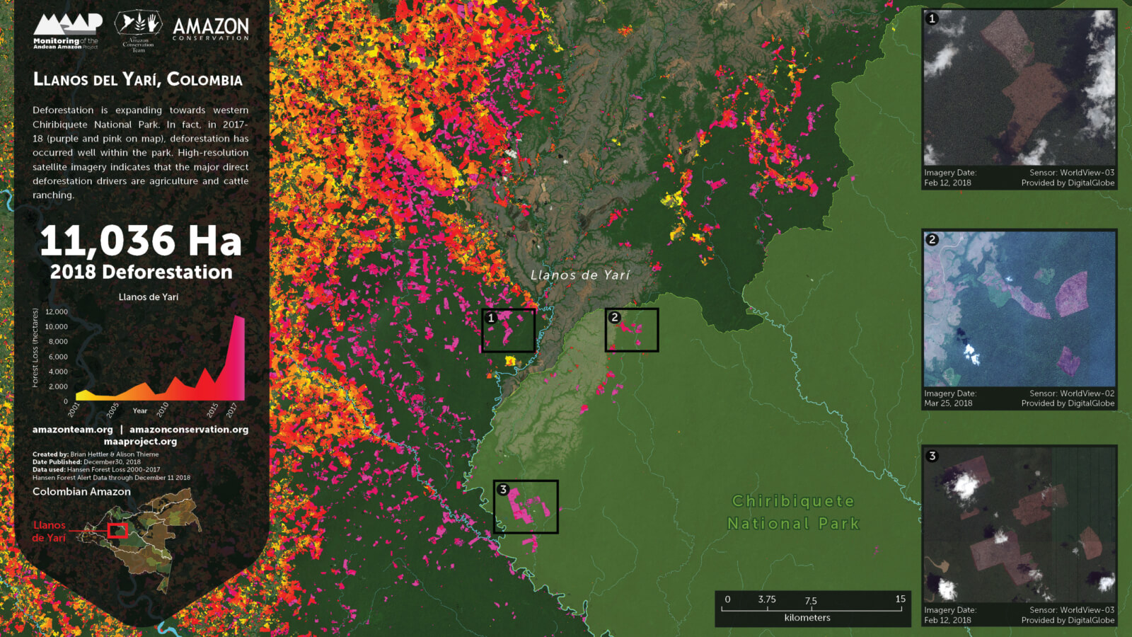
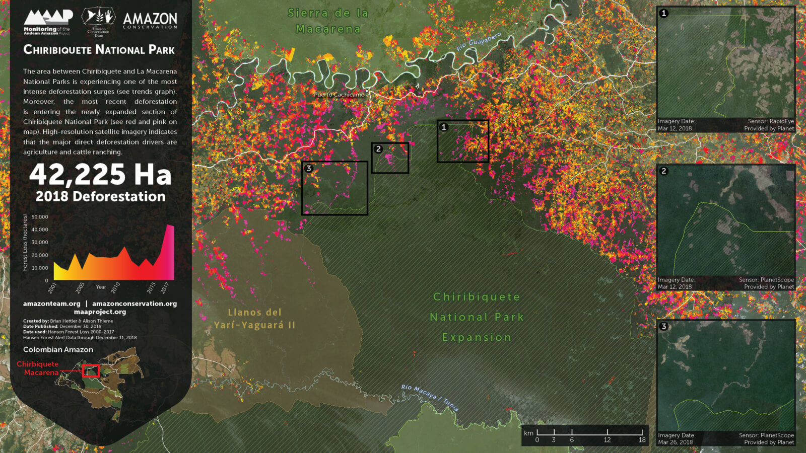
The largest concentration of 2018 forest loss is in the northeast Colombian Amazon (494,000 acres). Out of this total, 11% (56,800 acres) occurred in national parks. National experts indicate that land grabbing has emerged as a leading direct driver of deforestation (Arenas 2018). See MAAP #97 for more information.

Zoom A shows the forest loss expanding towards western Chiribiquete National Park, including distinct deforestation in this protected area during 2018.

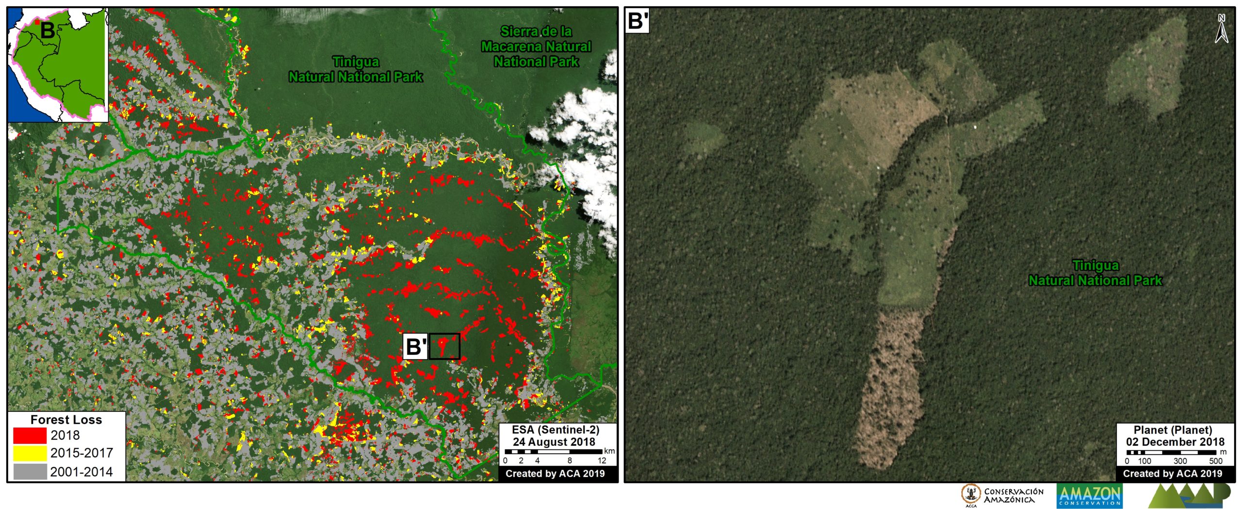
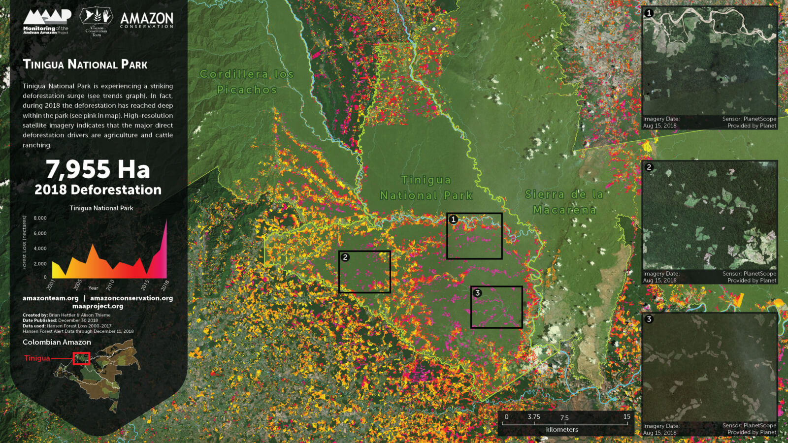
Zoom B shows the extensive 2018 deforestation (30,000 acres) within Tinigua National Park. A recent news report indicates that cattle ranching is one of the factors related to this deforestation.

Zoom A. Colombia-Chiribiquete. Data: Hansen/UMD/Google/USGS/NASA, SINAP, Planet, ESA
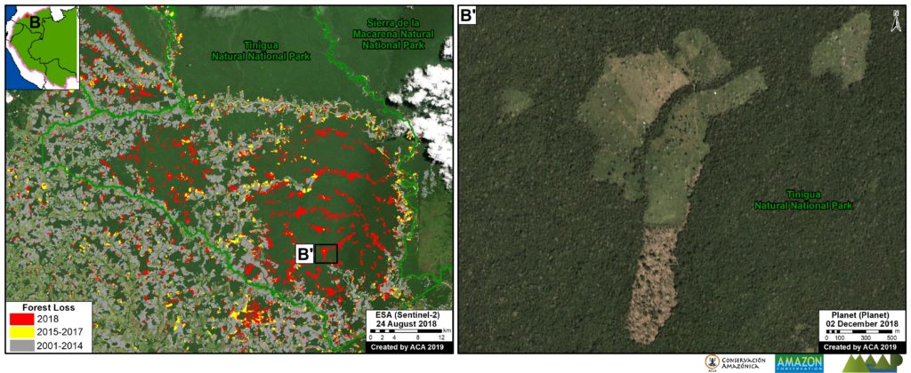
Zoom B. Colombia – Tinigua. Data: Hansen/UMD/Google/USGS/NASA, SINAP, Planet, ESA


Brazil (border with Bolivia)

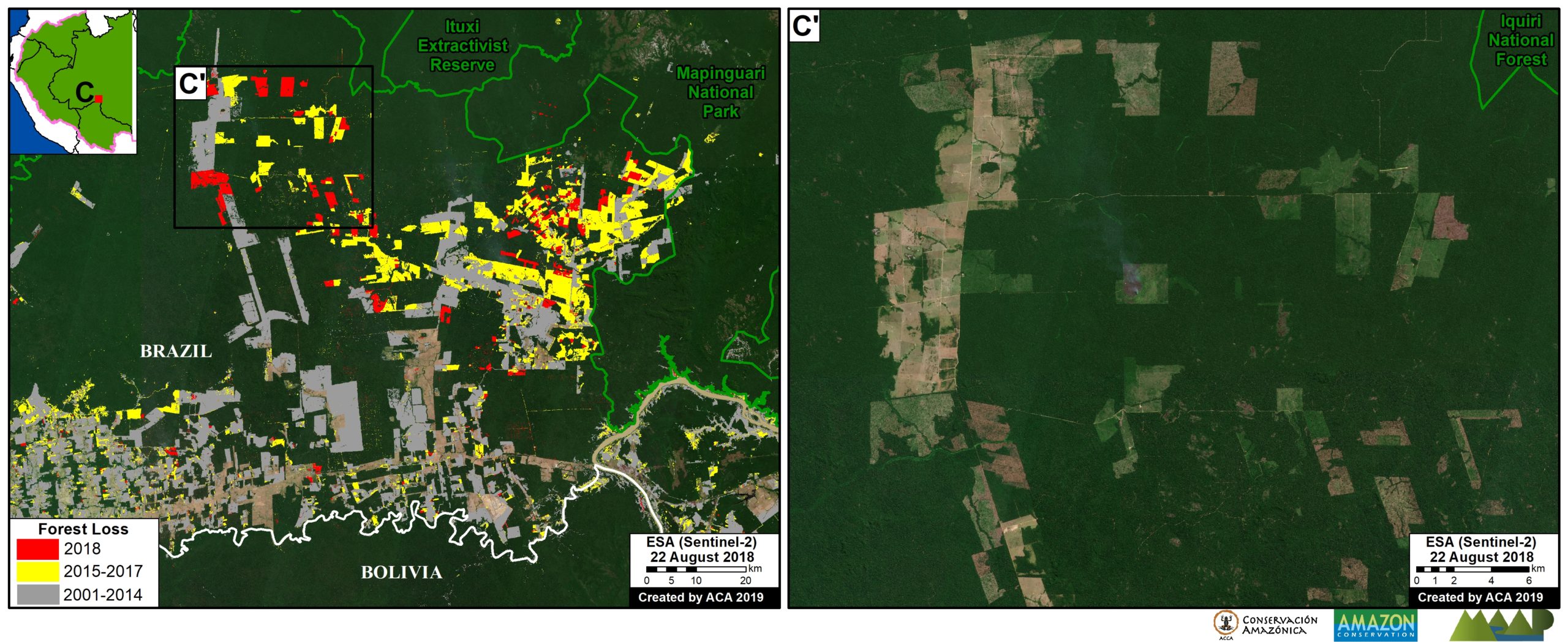
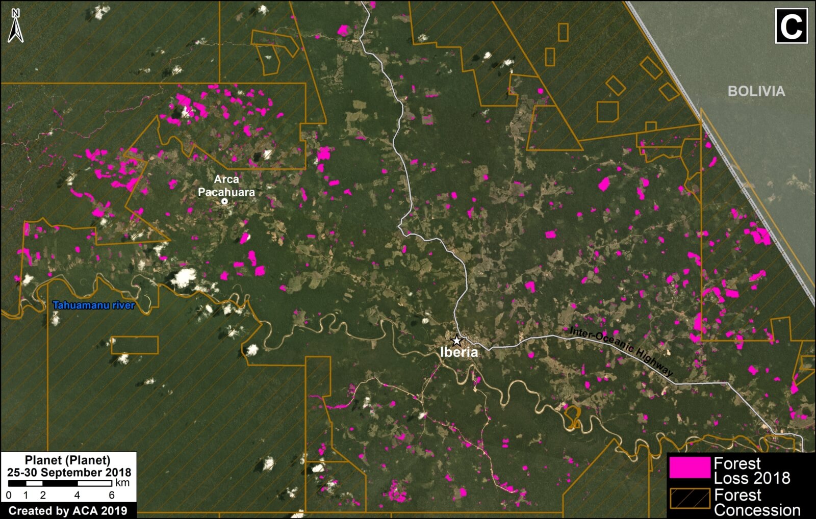
Another important result is the contrast between northern Bolivia (Pando department) and adjacent side Brazil (states of Acre, Amazonas, and Rondônia). Zoom C shows several deforestation hotspots on the Brazilian side, while the Bolivian side is much more intact.

Zoom C. Brazil, Bolivia border. Data: Hansen/UMD/Google/USGS/NASA, ESA, RAISG


Bolivia

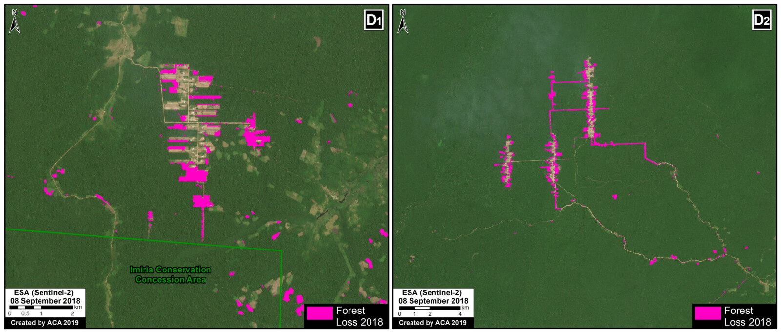
In Bolivia, the major forest loss hotspots are further south. Zoom D shows the recent deforestation (5,000 acres in 2018) due to agricultural activity associated with one of the first major Mennonite settlements in Beni department (Kopp 2015). The other Mennonite settlements are located further south.

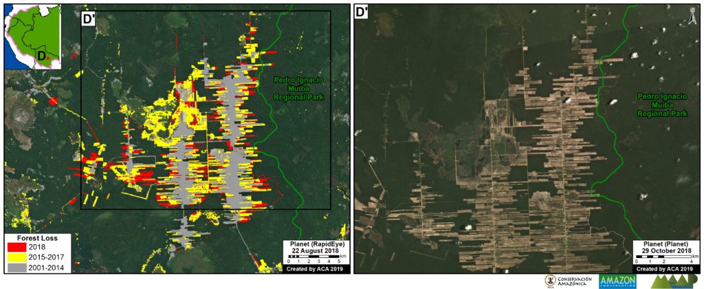
Zoom D. Bolivia, Black River Mennonite settlement. Data: Hansen/UMD/Google/USGS/NASA, SERNAP, Planet
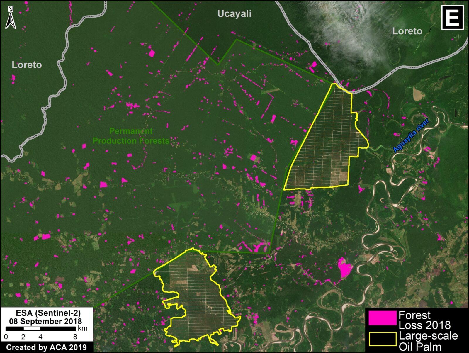
Peru

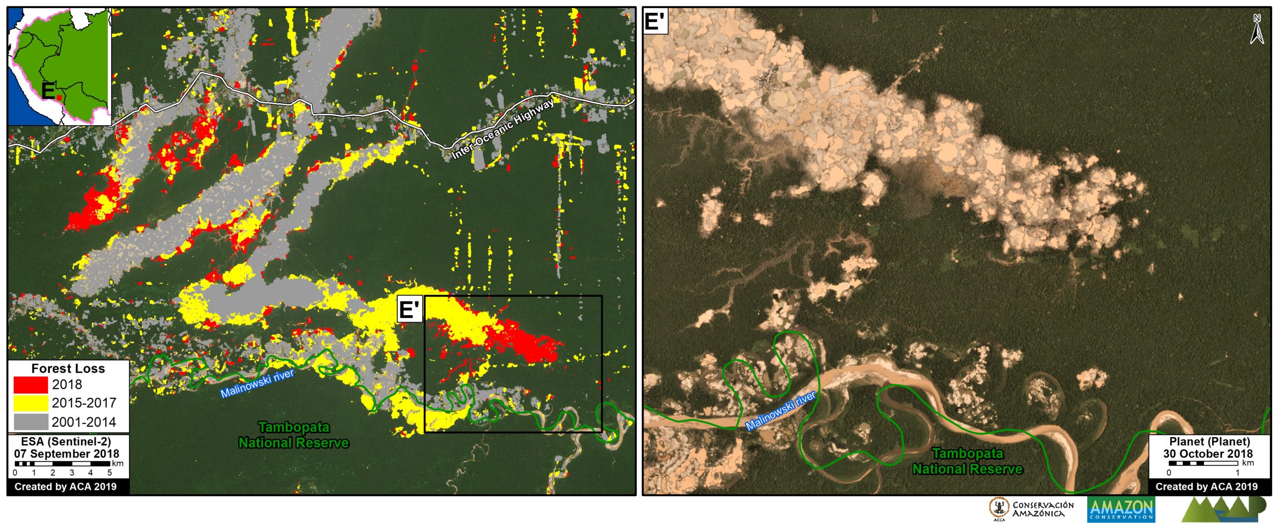
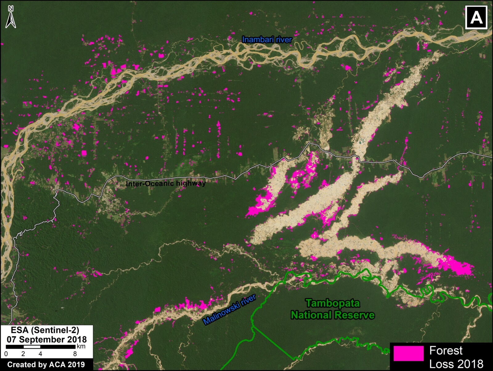
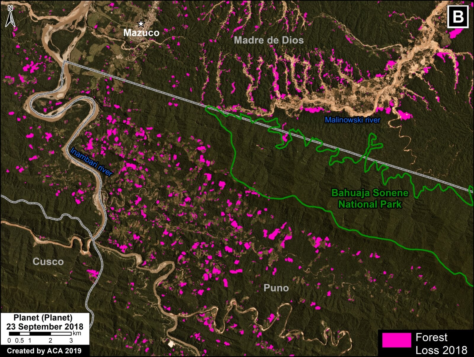
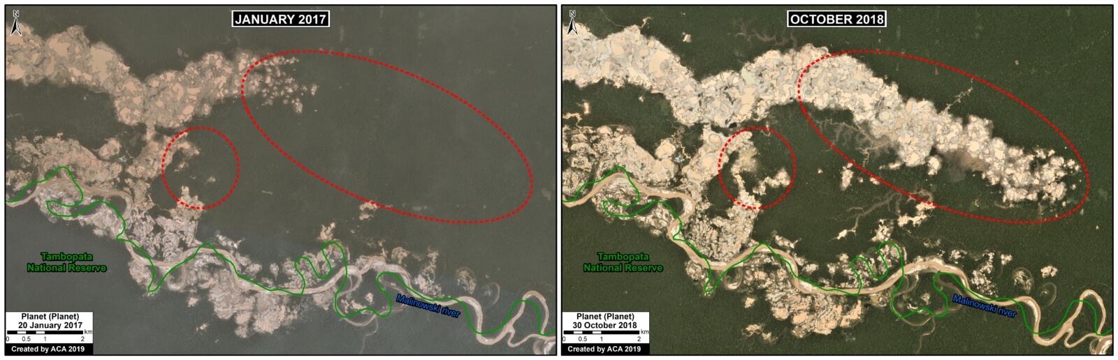
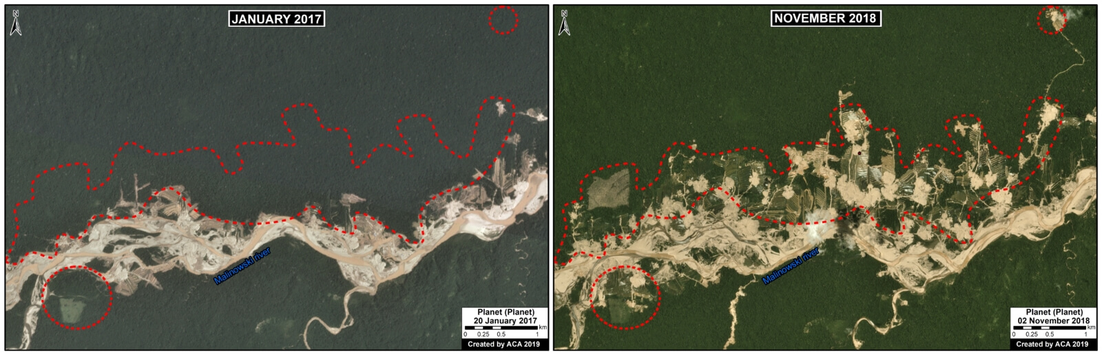
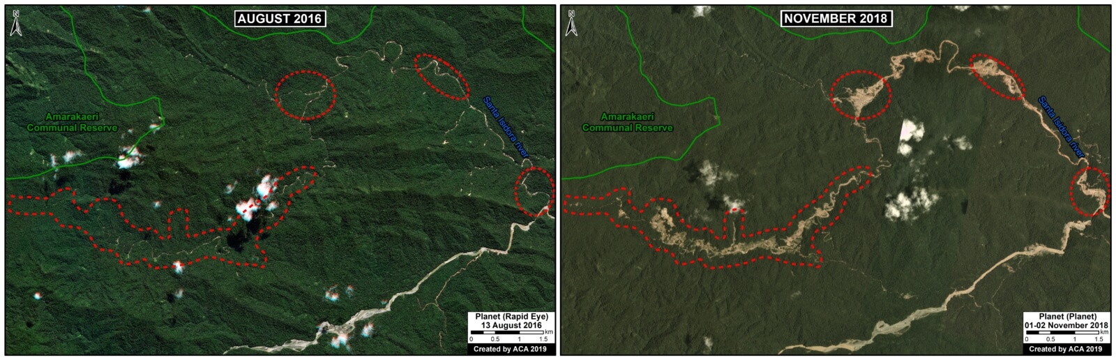
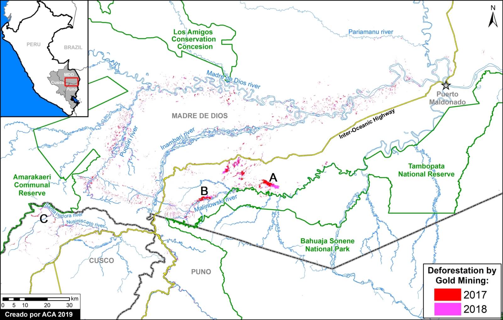
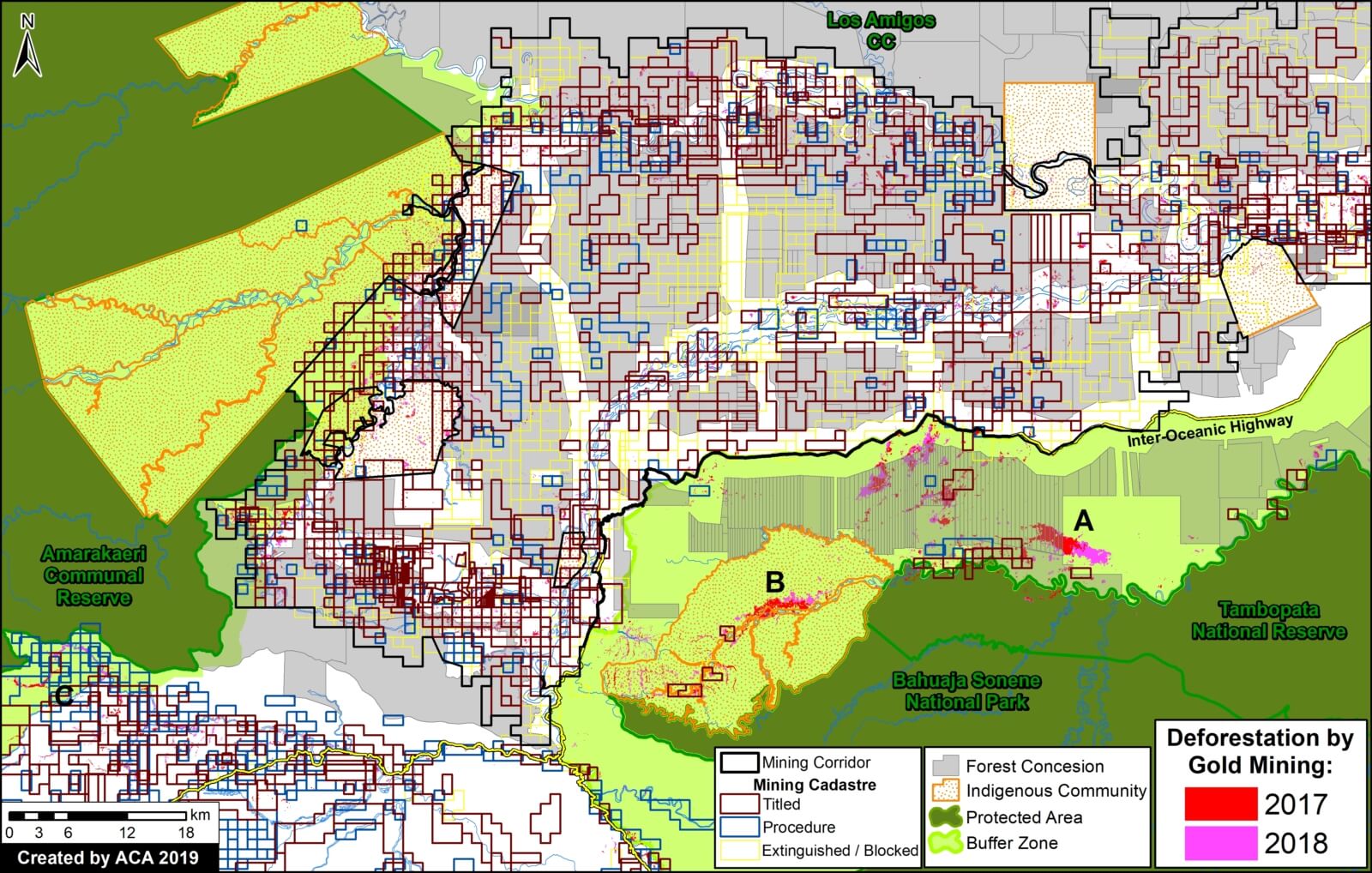
The Hansen data indicates over 200,000 acres of forest loss during 2018 in the Peruvian Amazon. One of the most important deforestation drivers, especially in southern Peru, is gold mining. We estimate 23,000 acres of gold mining deforestation during 2018 in the southern Peruvian Amazon (see MAAP #96).

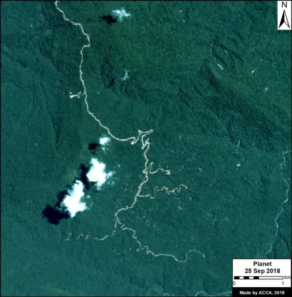
Zoom E shows the most emblematic case of gold mining deforestation: the area known as La Pampa.

It is important to emphasize, however, that in February 2019 the Peruvian government launched “Operation Mercury 2019” (Operación Mercurio 2019), a multi-sectoral and comprehensive mega-operation aimed at eradicating illegal mining and associated crime in La Pampa, as well as promote development in the region.

Zoom D. Peru – La Pampa. Data: Hansen/UMD/Google/USGS/NASA, SERNAP, Planet

Annex

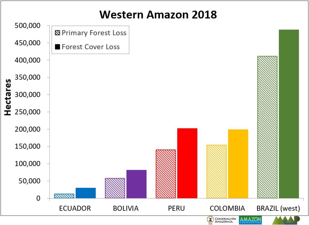
Annex. Forest cover and primary forest loss in the western Amazon.  Data: Hansen/UMD/Google/USGS/NASA, Global Forest Watch.

Methods

The 2018 forest loss data presented in this report were generated by the Global Land Analysis and Discovery (GLAD) laboratory at the University of Maryland (Hansen et al 2013) and presented by Global Forest Watch. Our study area is strictly what is presented in the Base Map: the areas within the Amazonian biogeographic boundary of the western Amazon.

Specifically, for our estimate of forest cover loss, we multiplied the annual “forest cover loss” data by the density percentage of the “tree cover” from the year 2000 (values >30%).

For our estimate of primary forest loss, we intersected the forest cover loss data with the additional dataset “primary humid tropical forests” as of 2001 (Turubanova et al 2018). For more details on this part of the methodology, see the Technical Blog from Global Forest Watch (Goldman and Weisse 2019).

All data were processed under the geographical coordinate system WGS 1984. To calculate the areas in metric units the UTM (Universal Transversal Mercator) projection was used: Peru and Ecuador 18 South, Colombia 18 North, Western Brazil 19 South and Bolivia 20 South.

Lastly, to identify the deforestation hotspots, we conducted a kernel density estimate. This type of analysis calculates the magnitude per unit area of a particular phenomenon, in this case forest cover loss. We conducted this analysis using the Kernel Density tool from Spatial Analyst Tool Box of ArcGIS. We used the following parameters:

Search Radius: 15000 layer units (meters)

Kernel Density Function: Quartic kernel function

Cell Size in the map: 200 x 200 meters (4 hectares / 9.88 acres)

Everything else was left to the default setting.

For the Base Map, we used the following concentration percentages: Medium: 10%-20%; High: 21%-35%; Very High: >35%.


References

Arenas M (2018) Acaparamiento de tierras: la herencia que recibe el nuevo gobierno de Colombia. Mongabay, 2 AGOSTO 2018. https://es.mongabay.com/2018/08/acaparamiento-de-tierras-colombia-estrategias-gobierno/

Goldman L, Weisse M (2019) Technical Blog: Global Forest Watch’s 2018 Data Update Explained. https://blog.globalforestwatch.org/data-and-research/blog-tecnico-explicacion-de-la-actualizacion-de-datos-de-2018-de-global-forest-watch

Hansen, M. C., P. V. Potapov, R. Moore, M. Hancher, S. A. Turubanova, A. Tyukavina, D. Thau, S. V. Stehman, S. J. Goetz, T. R. Loveland, A. Kommareddy, A. Egorov, L. Chini, C. O. Justice, and J. R. G. Townshend. 2013. “High-Resolution Global Maps of 21st-Century Forest Cover Change.” Science 342 (15 November): 850–53. Data available on-line from: http://earthenginepartners.appspot.com/science-2013-global-forest.

Kopp Ad (2015) Las colonias menonitas en Bolivia. Tierra. http://www.ftierra.org/index.php/publicacion/libro/147-las-colonias-menonitas-en-bolivia

Planet Team (2017). Planet Application Program Interface: In Space for Life on Earth. San Francisco, CA. https://api.planet.com

Turubanova S., Potapov P., Tyukavina, A., and Hansen M. (2018) Ongoing primary forest loss in Brazil, Democratic Republic of the Congo, and Indonesia. Environmental Research Letters  https://doi.org/10.1088/1748-9326/aacd1c 


Acknowledgements

We thank M. Terán (ACEAA), M. Weisse (GFW/WRI), A. Thieme (UMD), R. Catpo (ACCA) and A. Cóndor (ACCA) for helpful comments to this report.


Citation

Finer M, Mamani N (2019) Western Amazon – Deforestation Hotspots 2018 (a regional perspective). MAAP: 100.

Global Big Day at Los Amigos: 331 Species Sighted!

Exploring the trails of the station

The Global Big Day (GBD) is a date in which amateurs and experts in birds from around the world seek to see the greatest number of species in their locality. However, it is not only a date in which healthy competition between countries is observed, but also a great opportunity to educate about the diversity of birds worldwide. Like every year, at Los Amigos we were eager to participate in this event and give our best.

At the station, three bird guides from the regions of Madre de Dios and Cusco led this year’s GBD. Jose Luis Avendaño, Percy Avendaño and Cesar Bollatty have more than 20 years of experience touring Peru, including numerous visits to the station. Their knowledge of the species in the area and the station was key to end the day with a total of 331 species sighted, a new record for the station in a GBD.

On May 4, at 4:30 in the morning we were already on the trails in search of the most nocturnal species. Among them we recorded the Crested Owl (Lophostrix cristata), the Long-tailed Potoo (Nyctibius aethereus) and the Ocellated Poorwill (Nyctiphrynus ocellatus). The search for the various species of the station continued until 3:30 in the afternoon, when a heavy rain caused the forest to be silenced and we had to stop our search. After eleven hours of intense search, we are the second group with the most species sighted in Peru!

Although we could not spot species such as the Pale-winged Trumpeter (Psophia leucoptera) and the Cocoi Heron (Ardea cocoi), species commonly sighted in Los Amigos, we managed to spot other species not so easily observed in other places. The Pavonine Quetzal (Pharomachrus pavonivus), the Great Jacamar (Jacamerops aureus), the Royal Flycatcher (Onychorhynchus coronatus), the Spangled Continga (Cotinga cayana) and the Bar-bellied Woodcreeper (Hylexetastes stresemanni) are among the rare species that we spotted during this event.

A Long-billed Starthroat  (Heliomaster longirostris) spotted at the station. PC: Jose Luis Avendaño

Jose Luis Avendaño, Percy Avendaño y Cesar Bollatty after a long day of birdwatching. PC: Arianna Basto.

The Global Big Day 2019 was a great day for Los Amigos. Everyone who participated had a great day, enjoying the diversity offered by the station and always learning a little more. I’m sure the birders around the world enjoyed May 4th as much as we did at the station!

MAAP #99: Detecting Illegal Logging In The Peruvian Amazon

New logging road in the Peruvian Amazon. Data: Planet.

In the Peruvian Amazon, most of the logging is selective (not clearcutting), with the targets being higher-value species. Thus, illegal logging is difficult to detect with satellite imagery.

In MAAP #85, however, we presented the potential of satellite imagery in identifying logging roads, which are one of the main indicators of logging activity in the remote Amazon.

Here, we go a step further and show how to combine logging road data with additional land use data, such as forestry licenses and concessions, to identify possible illegal logging.

This analysis, based in the Peruvian Amazon, has two parts. First, we identify the construction of new logging roads in 2018, updating our previous dataset from 2015-17 (see Base Map).

Second, we analyze these new logging roads in relation to addition spatial information now available on government web portals,* in order to identify possible illegality.

*We analyzed information on several websites now available from national and regional authorities, such as SISFOR (OSINFOR), GEOSERFOR (SERFOR), and IDERs (Spatial Data Infrastructure of Regional governments). These new resources provide valuable information, however, may have limitations in ability to constantly update information on the status of concessions and forest permits.

Two Ancient Icons of the Neotropics

The Harpy Eagle (Harpia harpyja) and the Shihuahuaco tree (Diptheryx micrantha) are iconic species of the Neotropics that play key roles in the health of the ecosystem.

The harpy eagle is the heaviest and most powerful raptor inhabiting the canopy of rainforests. Its historic distribution ranges from southern Mexico to northeastern Argentina. While the variety in its diet suggests an opportunistic foraging behavior, it feeds mostly on arboreal mammals.

The mighty harpy eagle (Hapia harpyja) occasionally needs a break. Picture taken at Los Amigos Birding Lodge. PC: Rich Hoyer

Already hard to spot in the wild due to hunting and habitat loss, the harpy eagle population has plummeted in many countries of Central America.  An obstacle to its recovery is its slow reproductive rate: the eagle generally breeds every two to three years, with a single offspring per nesting effort.

A single shihuahuaco (Diptheryx micrantha) tree might sequester a third of all carbon stored in a hectare of primary forest. PC: Gianella Espinosa – Arbio

The shihuahuaco, meanwhile, is an emergent tree of the canopy that can reach a height of over 50 meters. It is patchily distributed in South America from Colombia to Bolivia. Shihuahuaco seeds and fruits are a source of food for species such as bats, agoutis, macaws, and hawks.

The slow-growing shihuahuaco can take centuries to reach its maximum height. Though not classified as endangered, it is critically threatened by logging and deforestation. In Peru, due to its hard wood and resistance to rot, the shihuahuaco is one of the most exported timber species, both legally and illegally.

Deforestation is the two species’ common destroyer: it has decreased the availability of prey and nesting sites for the eagle, while reducing disperser populations and suitable habitat for the shihuahuaco.

In a forest, the absence of large predators is associated with decreased tree diversity. The harpy eagle helps controls the presence of herbivores and thus enables many tree species to propagate. While standing, the shihuahuaco is an ecologically important species due to its broad buttresses that give structural integrity to the forest; when it falls, it leaves large gaps, facilitating successional forest growth. Further, because of the large amount of carbon a single shihuahuaco tree can store, it is a key species to fight the effects climate change.

One of the many shihuahuaco (Diptheryx micrantha) seedlings being planted throughout the station. PC: Arianna Basto

Because of its great size, for nesting, the harpy eagle depends on emergent trees of the canopy, one of the most important being the shihuahuaco. Locals and researchers have described the close relationship between these two species. Notably, eagle nests built on shihuahuaco branches will serve for more than one reproductive season.

At Los Amigos, we are planting over a hundred shihuahuaco seedlings. Eventually, the shihuahuaco will be a common sight here… and, with luck, so will the majestic eagle.

Further reading:

  • Aguiar-Silva, F. H., Sanaiotti, T. M. & Luz, B. B. (2014). Food Habits of the Harpy Eagle, a top Predator from the Amazonian Rainforest Canopy. Journal of Raptor Research, 48(1): 24-35. URL: https://doi.org/10.3356/JRR-13-00017.1
  • Putzel, L., Petersa, C. M. & Romod, M. (2011). Post-logging regeneration and recruitment of shihuahuaco (Dipteryx spp.) in Peruvian Amazonia: Implications for management. Forest Ecology and Management 261 (2011) 1099–1105. doi:10.1016/j.foreco.2010.12.036

MAAP #98: Deforestation Hotspots In The Peruvian Amazon, 2018

Base Map. 2018 Deforestation Hotspots. Data: PNCB/MINAM, SERNANP

Thanks to early warning forest loss alerts,* we are able to make an initial assessment of the 2018 deforestation hotspots in the Peruvian Amazon.

The Base Map highlights the medium (yellow) to high (red) hotspots. In this context, hotspots are the areas with the highest density of forest loss alerts.

Note that the most intense hotspots are concentrated in the southern Peruvian Amazon, particularly the Madre de Dios region. In previous years, intense hotspots were also concentrated in the central Peruvian Amazon.

Next, we focus on 5 hotspots of interest (Zooms A-E).

A. La Pampa (Madre de Dios)
B. Bahuaja Sonene National Park (surroundings) (Madre de Dios, Puno)
C. Iberia (Madre de Dios)
D. Organized Deforestation (Ucayali, Loreto)
E. Central Amazon (Ucayali, Huánuco)

*The data presented in this report is an estimate based on early warning data generated by the National Program of Forest Conservation for the Mitigation of Climate Change of the Ministry of the Environment of Peru (PNCB/MINAM). We also analyzed University of Maryland GLAD alerts, obtained from Global Forest Watch.

A. La Pampa (Madre de Dios)

Zoom A shows two important cases in the southern Peruvian Amazon (Madre de Dios region). First, gold mining deforestation south of the Interoceanic Highway in the area known as La Pampa. It is important to emphasize that the Peruvian government just started “Operation Mercury 2019” (Operación Mercurio 2019), a multi-sectoral and comprehensive mega-operation aimed at eradicating illegal mining and associated crime in La Pampa, as well as promote development in the region. Second, deforestation due to agricultural activity north of the highway. As in all the zoom maps below, pink indicates forest loss in 2018.

Zoom A. La Pampa. Data- PNCB:MINAM, SERNANP, ACCA, ESA

B. Bahuaja Sonene National Park (surroundings) (Madre de Dios, Puno)

Zoom B also shows two important cases in the southern Peruvian Amazon (regions of Madre de Dios and Puno), surrounding Bahuaja Sonone National Park. First, to the north of the park, is gold mining deforestation along the upper Malinowski River. The Peruvian protected areas agency (SERNANP) points out that they have limited the deforestation south of the river (direction towards the national park) due to their intensified patrols on that side. Second, to the south of the park, is non-mining (partly agricultural) deforestation.

Zoom B. Bahuaja Sonene (surroundings). Data- PNCB:MINAM, SERNANP, Planet


C. Iberia (Madre de Dios)

Zoom C takes us to the other side of Madre de Dios, around the town of Iberia, near the border with Brazil and Bolivia. This area is experiencing extensive deforestation due to agricultural activity. There most intense deforestation is just of Iberia, where a religious community of farmers (Arca Pacahuara) is reportedly establishing large corn plantations (References 1-2). Much of the 2018 (and 2017) deforestation is occurring within forest concessions, where agriculture is not permitted.

Zoom C. Iberia. Data- PNCB:MINAM, SERNANP, Planet


D. Organized Deforestation (Ucayali, Loreto)

In 2018 we documented two similar cases in the central Peruvian Amazon. Both have similar forms of organized deforestation, characterized by what seems to be agricultural plots arranged along new access roads. Zoom D shows the Masisea case (left panel, zoom D1) and the Sarayaku case (right panel, zoom D2). See MAAP #92 for more information.

Zoom D. Organized deforestation. Data- PNCB:MINAM, SERNANP, ESA


E. Central Amazon (Ucayali, Huánuco)

As in previous years, there was extensive deforestation in the central Peruvian Amazon (Ucayali and Huánuco regions). Zoom E shows an example: small and medium-scale deforestation surrounding a pair of large-scale oil palm plantations. Some of the recent deforestation is occurring within “Permanent Production Forests,” forestry-zoned areas where agriculture is not permitted. This area also corresponds to the proposed territorial title of the indigenous Shipibo community of Santa Clara de Uchunya (see here for more information).

Zoom E. Central Amazon. Data- PNCB:MINAM, SERNANP, ESA


Methodology

We conducted this analysis using the Kernel Density tool from Spatial Analyst Tool Box of ArcGIS, using the following parameters:

Search Radius: 15000 layer units (meters)
Kernel Density Function: Quartic kernel function
Cell Size in the map: 200 x 200 meters (4 hectares)
Everything else was left to the default setting.

The data presented in this report is an estimate based on early warning data generated by the National Program of Forest Conservation for the Mitigation of Climate Change of the Ministry of the Environment of Peru (PNCB/MINAM). We also analyzed University of Maryland GLAD alerts, obtained from Global Forest Watch.


References

1. CIFOR 2016

2. GOREMAD 2016

Planet Team (2017). Planet Application Program Interface: In Space for Life on Earth. San Francisco, CA. https://api.planet.com


Citation

Finer M, Mamani N (2018) Deforestation Hotspots in the Peruvian Amazon, 2018. MAAP: 98.

Camera Traps: Colorfully Capturing Motmots

Our camera traps were set up to monitor a nest of the secretive giant armadillo (Priodontes maximus). However, during a recent recording session, a less reclusive forest friend stole the spotlight: a rufous motmot (Barypththengus martii). This curious bird belongs to the Momotidae family, which comprises a group of colorful arboreal species.

An Amazonian motmot (Momotus momota) showing off its racket-like tail. Photo: Will Sweet

Endemic to the tropics, among birds of the region, the motmots range in size from medium to medium-large. Despite their bright plumage—a combination of greens, blues and rufous (rust-like) colors—they are hard to spot. Most of the species have a long tail, and a few have two longer feathers that have racket-like tips. In contrast with many other bird families, motmots exhibit no sexual dimorphism: males and females look much alike, though on closer inspection males tend to be larger and have longer tails.

Spotting a motmot can be challenging because they sit still for long periods. They can be observed when they sally out to catch their prey, or through the sideways movement of their tails. It has been hypothesized that the turquoise-browed motmot (Eumomota superciliosa) uses this latter movement to signify to a predator that it has awareness of its presence. Thus advised, the predator might desist from an attack, preventing an unnecessary waste of energy on both sides.

Motmots can be found in a variety of forest types, from lowland tropical forest to template forests. Some species can even adapt to man-made habitats such as plantation and gardens. Motmots take their prey from leaves, twigs or branches of trees or other vegetation, and can be seen on the ground too. Smaller species feed on insects while larger ones additionally feed on other invertebrates, small vertebrates and fruits. The larger species like the Amazonian motmot (Momotus momota) and the rufous motmot have been reported to feed on bats and on poison dart frogs, respectively, in the latter case with no apparent harm to themselves.

A rufous motmot (Barypththengus martii) inspects a burrow of the giant armadillo (Priodontes maximus).

 Most of the Momotidae have similar breeding behaviors. An exception is the tody motmot (Hylomanes momotula), which is also morphologically atypical and the most primitive species of the family. These ground-nesting birds use their feet to loosen the soil to later dig their nesting burrows. Both mates share this work and the chick rearing. Motmots are solitary nesters, but when limited suitable space is available, they may concentrate in groups. A new burrow is dug for each nesting season, often close to the previous burrow. As our camera trap and other studies have reported, the rufous motmots also use old burrows of armadillos and other mammals to nest.

Like many other Neotropical birds, the motmots are understudied, and there are much more to learn about them. Who knows which other surprises they may hold!

Further readings:
Skutch, A. F. (1971). Life History of the Broad-billed Motmot with Notes on the Rufous Motmot. The Wilson Bulletin Vol. 83, Nro 1.
Murphy, T. G. (2006). Predator-elicited visual signal: why the turquoise-browed motmot wag-displays its racketed tail. Behavioral Ecology.


MAAP #97: Deforestation Surge In The Colombian Amazon, 2018 Update

The Colombian Amazon is currently experiencing a deforestation surge (see graph).

The surge started three years ago (2016) and peaked in 2017 with the highest annual deforestation on record (214,744 hectares).*

Deforestation remains high in 2018: 156,722 hectares (based on early warning alert data).* If this estimate is confirmed, it would be the second highest on record (behind just 2017).

National experts indicate that land grabbing (acaparamiento de tierras) is an increasingly dominant direct driver of deforestation.

*Data from the University of Maryland. Annual data from Hansen et al (2013) [citation below] and 2018 data from GLAD alerts.

MAAP Colombia is a collaboration between Amazon Conservation and Amazon Conservation Team., funded by the MacArthur Foundation.

We also present a Base Map that shows the 2018 deforestation hotspots. Note that the deforestation is concentrated in three departments located in the transition area between the Amazon and Andes: Guaviare, Caqueta, and Meta.

We highlight the location of three critical areas that are examined in greater detail below: 1) Llanos de Yari, 2) Chiribiquete- La Macarena, and 3) Tinigua National Park.

For the Base Map and Zooms below, please click on the image to enlarge or download.

Base Map. Deforestation hotspots in the Colombian Amazon. Click to enlarge. Data- UMD:GLAD, Hansen:UMD:Google:USGS:NASA, PNN, SIAC, RAISG

Zoom 1: Llanos de Yari

Zoom 1 shows deforestation expanding towards western Chiribiquete National Park. In fact, in 2017-18 (purple and pink on map), deforestation has occurred well within the park. 

Zoom 1. Llanos de Yari. Click to enlarge. Data- DigitalGlobe, UMD:GLAD, Hansen:UMD:Google:USGS:NASA, PNN, SIAC, RAISG

Zoom 2: Chiribiquete – La Macarena

As we first reported in MAAP #86, the area between Chiribiquete and La Macarena National Parks is currently experiencing one of the most intense deforestation surges. Zoom 2 shows the most recent deforestation (indicated in red and pink) is entering the newly expanded section of Chiribiquete National Park. 

Zoom 2. Chiribiquete – La Macarena. Click to enlarge. Data- Planet, UMD:GLAD, Hansen:UMD:Google:USGS:NASA, PNN, SIAC, RAISG.

Zoom 3: Tinigua National Park

Zoom 3 shows how 2018 has seen a surge of deforestation deep within Tinigua National Park (see pink). 

Zoom 3. Tinigua National Park. Click to enlarge. Data- Planet, UMD:GLAD, Hansen:UMD:Google:USGS:NASA, PNN, SIAC, RAISG

References

Planet Team (2017). Planet Application Program Interface: In Space for Life on Earth. San Francisco, CA. https://api.planet.com

Hansen, M. C., P. V. Potapov, R. Moore, M. Hancher, S. A. Turubanova, A. Tyukavina, D. Thau, S. V. Stehman, S. J. Goetz, T. R. Loveland, A. Kommareddy, A. Egorov, L. Chini, C. O. Justice, and J. R. G. Townshend. 2013. “High-Resolution Global Maps of 21st-Century Forest Cover Change.” Science 342 (15 November): 850–53. Data available on-line from:http://earthenginepartners.appspot.com/science-2013-global-forest.


Citation

Hettler B, Thieme A, Finer M (2018) Deforestation Surge in the Colombian Amazon: 2018 update. MAAP: #96.

New Year, New Fellows! Announcing the 2019 Jonathan Franzen Fellows

Two years ago, the Los Amigos Bird Observatory opened its doors to promote avian research and conservation in one of the most biodiverse ecosystems in the world: the Amazon basin. To continue with our commitment, last year, we launched our second Franzen Fellowship call for applications, targeting students and young researchers interested in avian research. The group of promising and highly qualified candidates that applied made this a tough decision. We congratulate all the candidates, and are excited to present our 2019 Franzen Fellows!

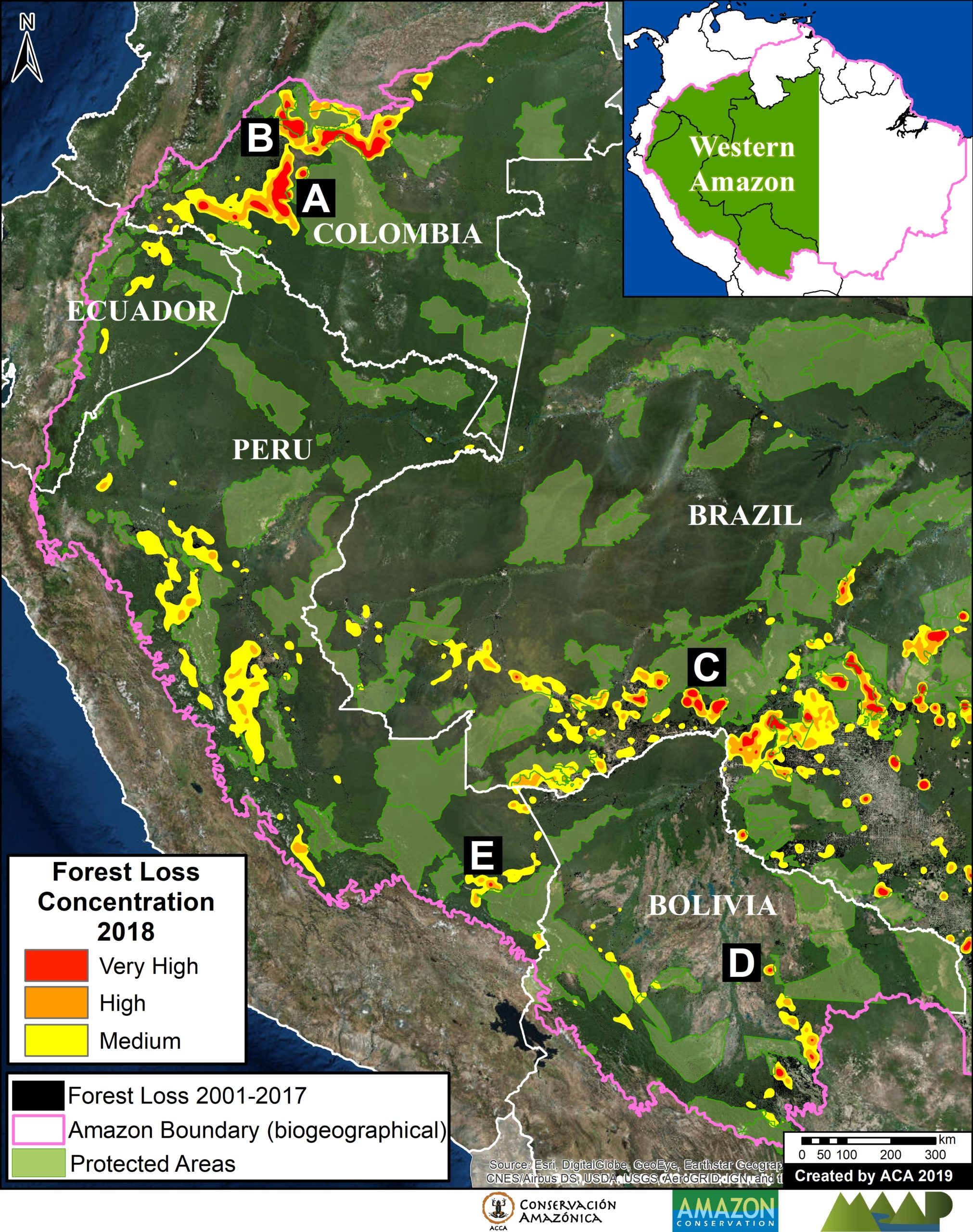
Jessica Pisconte holds a degree in biology from the Universidad Nacional San Luis Gonzaga de Ica, Peru. Her interest in avian conservation was born in the Paracas National Reserve, after which she joined a wide range of research projects to learn about the importance of birds in coastal, mountain and Amazonian ecosystems. She is currently working as a park ranger in the Tambopata National Reserve in Peru’s Madre de Dios region. As the threats due to illegal mining increased in this region, seriously affecting the environment, Jessica was motivated to research key areas to understand its impact. Los Amigos will be her starting point to study the effects on birds of mercury from gold mining. Through this project, Jessica seeks to contribute to the conservation of and knowledge regarding birds in the Peruvian Amazon.


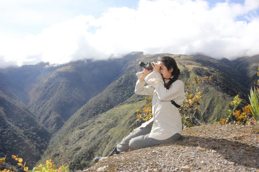
Lisset Goméz studied biological sciences at the Universidad Mayor de San Marcos in Lima, Peru. Her interests include ecology, reproductive biology, and conservation of bird communities, and she has been involved in a number of courses and projects around Peru that embrace these topics. Lisset volunteered with the National Service of Natural Protected Areas (SERNANP) and at the Wayquecha Biological Station, where she assisted in a project on plant-hummingbird interactions.  Through her participation in the Course on Field Techniques and Tropical Ecology at the Cocha Cashu Biological Station in Manu National Park, she strengthened her knowledge of the tropical forest and started conducting her own research. As a Franzen Fellow, she will try to understand the habitat requirements of woodpeckers of the genera Campephilus and Celeus. She will address her research question by identifying the woodpecker species’ tree preferences when excavating their nesting cavities.


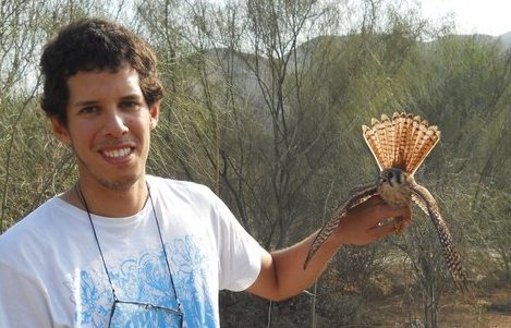
Diego Guevara got his biology degree from the Universidad Nacional Agraria La Molina (UNALM) in Lima, Peru and holds a master’s degree in applied ecology from the University of East Anglia, UK. He is an associate researcher at the Centro de Ornitología y Biodiversidad (CORBIDI) and general coordinator of the UNALM banding station. He has experience in projects related to the impact of human activities on biodiversity, with a special interest in the responses of bird communities and the habitat requirements of endangered species. Additionally, he is interested in studying the ecotoxicology and physiology of birds, which led him to apply to the Franzen Fellowship. His project will focus on the fluvial and bamboo forest bird community, studying the impacts of mining on its bird communities.


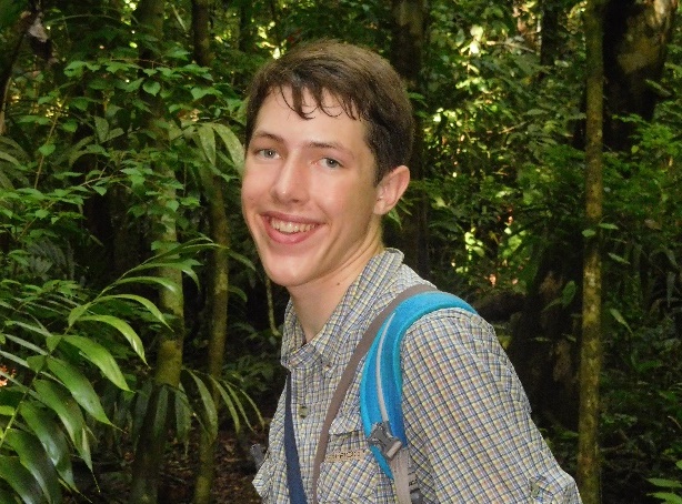
Patrick Newcombe attends the Sidwell Friends School in Washington, D.C., making him the youngest of our fellows. His interest in birds started as a young child, leading to his engagement in bird research. In 2018, with Osa Conservation in Costa Rica, he collected field data on the flocking behavior and diet of the endangered black-cheeked ant tanager (Habia atrimaxillaris). He is currently analyzing weather surveillance radar data to study the flight strategies of migratory birds on the Pacific Flyway as part of a project led by Dr. Kyle Horton from Cornell University. At Los Amigos, his project will focus on Manakin leks around the station, from which he will identify and learn about their habitat use patterns.
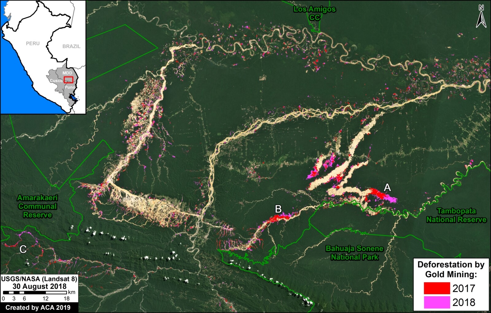
Stay tuned to learn more about our Fellows and their projects!


MAAP #96: Gold Mining Deforestation At Record High Levels In Southern Peruvian Amazon

Gold mining deforestation has been at record high levels in both 2017 and 2018 in the southern Peruvian Amazon.

Based on an analysis of nearly 500 high-resolution satellite images (from Planet and DigitalGlobe), we estimate the deforestation of 18,440 hectares across southern Peru during these last two years. That is equivalent to 45,560 acres (or 34,400 American football fields) in just two years.

The Base Map highlights this recent deforestation, with 2017 in red and 2018 in pink. The Reference Map in Annex 1 shows our full study area.

Base Map. Gold mining deforestation in southern Peruvian Amazon. Data- USGS/NASA, MAAP, SERNANP

2017 had the highest gold mining deforestation on record at the time: 9,160 hectares (22,635 acres). According to recent research led by CINCIA (Centro de Innovación Científica Amazónica), this was the highest annual total on record dating back to 1985*.

In 2018, we found the gold mining deforestation was even higher: 9,280 hectares (22,930 acres).

Thus, combined, 2017-18 had the highest two-year deforestation total on record: 18,440 hectares (45,565 acres).

Note the location of Zooms (A-C) shown in greater detail below. These zooms represent three of the most threatened areas: A) La Pampa, B) Upper Malinowski, and C) Camanti.

Click (or right click) to enlarge (or download) images.

*CINCIA reports 9,860 hectares of gold mining deforestation in 2017 (CINCIA 2018, Caballero Espejo et al 2018), an estimate even higher than ours.


Zoom A: La Pampa

Image A shows the gold mining deforestation of 1,685 hectares (4,164 acres) between 2017 (left panel) and 2018 (right panel) in an area known as La Pampa (Madre de Dios region). Red indicates the major deforestation fronts.

MAAP96Image A. La Pampa. Data- Planet, MAAP

As seen in the Land Use Map below (Annex 2), most of the recent mining deforestation in La Pampa is clearly illegal, concentrated in reforestation concessions and the buffer zone of Tambopata National Reserve.

According to the web portal GEOCATMIN (Geological Information System and Mining Register), developed by INGEMMET (Geological Mining and Metallurgical Institute of Peru), all titled mining concessions in the area are currently “without mining activity.” None are in authorized Exploration or Exploitation phase. Most of the mining activity is outside these concessions and in areas not authorized for mining.


Zoom B: Upper Malinowski

Image B shows the gold mining deforestation of 760 hectares (1,878 acres) between 2017 (left panel) and 2018 (right panel) along the upper stretches of the Malinowski River in the Madre de Dios region. Red indicates the major deforestation fronts.

Image B. Upper Malinowski. Data- Planet, MAAP.jpg

As seen in the Land Use Map below (Annex 2), the recent gold mining deforestation along the Upper Malinowski is advancing in the Kotsimba Native Community and within the buffer zone of Bahuaja Sonene National Park.

According to GEOCATMIN, all titled mining concessions in the area are currently “without mining activity.” None are in authorized Exploration or Exploitation phase. Most of the mining activity is outside these concessions and in areas not authorized for mining.


Zoom C: Camanti

Image 4 shows the gold mining deforestation of 335 hectares (828 acres) between 2016 (left panel) and 2018 (right panel) in the Camanti area of the Cusco region. Red indicates the major deforestation fronts. Note the increasing proximity of the mining to Amarakaeri Communal Reserve.

Image C. Camanti. Data- Planet, MAAP

As seen in the Land Use Map below (Annex 2), the recent gold mining in the Camanti area is advancing in mining concessions that are “in process” of titling. According to GEOCATMIN, there are no titled concessions in the area that are in Exploration or Exploitation phase.


Annex 1: Reference Map

Annex 1 features a Reference Map of our full study area. The background is white to better indicate the mining deforestation areas. It also serves as a reference map with additional labels.

Reference Map. Gold mining deforestation in southern Peruvian Amazon. Data- MAAP, SERNANP

Annex 2: Land Use Map

Annex 2 features a Land Use Map with detailed data on mining concessions and other important land designations. The mining concession data comes from the web portal GEOCATMIN (Geological Information System and Mining Register), developed by INGEMMET (Geological Mining and Metallurgical Institute of Peru). We downloaded the data on January 2, 2019.

Land use Map. Data- INGEMMET, IBC, MINAGRI, SERNANP, Planet, UMD:GLAD, MINAM:PNCB

Methodology

We analyzed high-resolution satellite imagery (DigitalGlobe and Planet) for both 2017 and 2018 and digitized all new gold mining deforestation. Given the widespread mining across a large area, we also used automated forest loss alerts based on medium resolution Landsat imagery (PNCB/MINAM) to guide our analysis.

References

Centro de Innovación Científica Amazónica (CINCIA) (2018) Tres décadas de deforestación por minería aurífera en la Amazonía suroriental peruana. Resumen de Investigación No. 1.

Caballero Espejo et al. (2018) Deforestation and Forest Degradation Due to Gold Mining in the Peruvian Amazon: A 34-Year Perspective.  Remote Sens. 2018, 10 (12), 1903; https://doi.org/10.3390/rs10121903

Asner GP and Tupayachi R (2016) Environ. Res. Lett. 12 094004.

Planet Team (2017). Planet Application Program Interface: In Space for Life on Earth. San Francisco, CA. https://api.planet.com

Acknowledgements

We thank the following colleagues for helpful comments: Miles Silman (Wake Forest Univ), Sidney Novoa (ACCA), Ronald Catpo (ACCA), Efrain Samochuallpa (ACCA), Daniela Pogliani (ACCA), Alfredo Cóndor (ACCA), and Lorena Durand (ACCA).

Citation

Finer M, Mamani N (2018) Gold Mining Deforestation at Record High Levels in Southern Peruvian Amazon. MAAP: 96.